


Electric Fishing Fry Index Survey
Plymouth River Keepers (PRK)
April 2024
Hannah Parvin


Westcountry Rivers Trust Fry Index Survey Report – PRK 2023
Westcountry Rivers Trust is an environmental charity established in 1995 to restore, protect and improve the rivers, streams, and water environments in the region for the benefit of wildlife and people.
This report has been written and prepared by: Hannah
ParvinPublished by: Westcountry Rivers Trust
Rain Charm House, Kyl Cober Parc, Stoke Climsland, Callington, Cornwall, PL17 8PH.
Tel: 01579 372140
Email: info@wrt.org.uk
Web: www.wrt.org.uk
Charity no. 1135007
Company no. 06545646
Document history:
© Westcountry Rivers Trust: 2024. All rights reserved. This document may be reproduced with prior permission of the Westcountry Rivers Trust
Executive Summary
Westcountry Rivers Trust (WRT) undertook electric fishing (EF) surveys throughout the small streams of the Plymouth River Keepers project area, within Northwest Plymouth during the summer of 2023. The surveys are the third year of a three-year monitoring effort funded as part of the wider Plymouth River Keepers project (PRK). Salmon were absent at all survey sites, along with complete absence of any fish species at some of the survey sites. The only species that were present at some sites were brown trout and European eel. Conservation strategies, such as the Defend/Repair/Attack approach, can be applied on a sub catchment level with recommended fisheries management actions suggested to either improve or maintain salmonid habitat and numbers.
1. Introduction
The Westcountry Rivers Trust (WRT) undertook eight semi-quantitative fry index electric fishing surveys (FIS) on the small streams within the PRK project area within the Tamar catchment in August 2023 (Figure 1). The three streams have been named Reach 1, 2, and 3 within the wider PRK project. This was the third year of fish monitoring undertaken by WRT and forms part of establishing a long-term dataset of fry numbers.
Sites were selected based on potential fisheries improvement works that are scheduled be carried out within the project area. Monitoring will aid in understanding if improvements have been effective in increasing fish numbers and/or presence of already absent species. It is hoped that these sites will continue to be surveyed every year to build a strong baseline dataset for the catchment.

2. Methodology
2.1 Electric Fishing Protocols
Electric fishing uses a controlled electric current to induce fish to swim towards an anode and into a hand net, so that surveyors can record various biometric data. When carried out correctly by experienced and qualified surveyors it is not harmful to fish and once recovered, the fish are released back to the same reach from which they were caught. An
electric fishing backpack is used as this is the best method for targeting salmonids in the Westcountry, with improved ability to access a variety of watercourses.
There are several approaches to electric fishing assessments in rivers; quantitative, area based semi-quantitative and time based semi-quantitative methodologies. All three methods have their advantages and disadvantages. For the PRK catchment time based semi-quantitative is used.
A time-based, semi-quantitative electric fishing survey (otherwise known as fry index survey or FIS) is the preferred method (Crozier and Kennedy, 1994); where the independent variable is time. Five minutes of ‘live’ fishing is used to assess fry numbers over riffle habitat. No barrier nets are deployed as the survey area is defined by shallow fry habitat; therefore the catch efficiency is high. This method is relatively fast compared to other methods and is therefore well suited to catchment wide programmes. In the event that a fish is missed, surveyors will record this so that a catch efficiency can be calculated. If catch efficiency is less than 60% then the survey will be voided and the results labelled as such.
The aim of WRT’s catchment scale electric fishing programme is to build up a historical data set on each catchment and provide baseline information on population status. Monitoring long term trends helps to identify issues and potential actions. To properly achieve this, a representative number of surveys should be fished across all tributaries of a catchment and these sites should be repeated over consecutive years. The trends in results help to identify potential issues within the catchment, these may include but are not limited to:
• Upstream barriers to fish-passage
• Changes in habitat quality
• Potential changes in water quality
• Chronic diffuse pollution
• To monitor habitat improvements delivered within projects
• Targeted habitat interventions
2.2 Fisheries Conservation Strategy
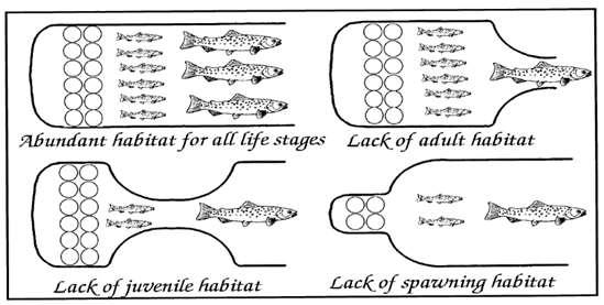
At project level, the data collected by electric fishing programmes can be used to identify long term trends in salmonid populations. Further investigation can then be conducted to isolate a specific issue which can then be addressed through delivery. Figure 2 below shows an example of different habitat issues and their effects on populations.
The ‘Defend/Repair/Attack’ strategy, developed by Ronald Campbell of the Tweed Foundation, is a widely accepted approach to riverine habitat restoration, suggesting proportionate responses to various states of habitat. The aim is to improve the quality of catchments to the point of ‘Defend’ to support robust fish populations.
Where these are in a very poor state, radical actions may be required to see a change. Conversely, where the stocks are already good, habitat re-engineering and stocking operations would be inappropriate. This concept helps divide catchment scale management for fisheries into priorities and therefore can help to maximise multiple benefits through targeted work.
2.3 Site Selection
Survey sites on the PRK catchment were selected to provide representative samples from distinct river reaches, characterised by habitat type, proximity to barriers or proximity to targeted restoration works. Catchment programmes are developed in partnership with stakeholders and other organisations and are often based on existing historic programmes. In turn this contributes to a long term fry index survey dataset where trends can be established, and positive or negative patterns of salmonid recruitment inferred from the findings
2.4Field Sampling and Data Analysis
Initially the survey programme is confirmed with the funder and stakeholders; permission is then sought from the Environment Agency in the form of an FR2 (a license to capture fish with equipment other than a rod and line). Landowner permission for all sites is obtained prior to surveying. For time-based surveys two members of staff are required, for area-based electric fishing a minimum of three surveyors are required. Once on site, the water temperature is taken to ensure it is below 18°C, this temperature limit is set by the Environment Agency to avoid excessive physiological stress to salmonids. The conductivity of the water is measured in order to set an appropriate voltage on the
equipment. A frequency is set based on the target species, for salmonids this is between 40-60Hz, and a duty cycle is set, however 100% duty cycle (known as smooth) is preferential for fish welfare and when 100% duty cycle is set the frequency becomes obsolete. The chosen survey method is then conducted.
All salmonids are identified to species level and fork length is measured and recorded. Prescence of other species within the survey are also recorded. The captured fish are placed in aerated containers until they are fully recovered. They are then released back to the reach they were caught. Following completion of the survey, the length and width of the site is measured and recorded.
Fish length data is plotted on a length frequency histogram, which allows thresholds for fry and parr to be determined. Trout fry were considered to be any individual measuring up to 95mm (Figure 3). Length frequency histograms are repeated for each catchment each year to reflect the temporal and spatial differences in fry.
Brown Trout Frequency Distribution 2023
Fry index surveys are classified according to Crozier and Kennedy (1994), the categories of which are displayed in Table 1.
Table 1: Semi-quantitative abundance categories for salmon fry (Crozier & Kennedy, 1994)
3. Results & Discussion
WRT surveyed eight FIS sites within the PRK area in August 2023 Weather during the survey window was changeable, with periods of heavy rainfall, however, surveyors carried out the surveys when conditions were safe, and when the rivers were not in spate or coloured. No salmon were recorded during the surveys. Trout were recorded at two of the eight sites, resulting in a fair classification at DS Tamerton Foliot Road and a poor classification at US Seven Stars. Trout numbers have been in decline across the three survey years. Eel were present at four of the eight sites in 2023, and increase from 2022.


Annual Salmonid Fry Survey Data PRK (2021-2023)
4. Recommendations
4.1 Defend/Repair/Attack
The strategy for restoration and conservation of sites suggested here broadly follows the “Defend, Repair, Attack” (DRA) concept (Table 6) developed by Ronald Campbell of the Tweed Foundation and has in the past been applied locally in the PRK catchment following results from the fry index surveys. The fry productivity of the rivers is assessed by a combination of historic semi-quantitative electric fishing results. These results are then applied in context of existing plans (e.g. DEFRAs Salmon Five Point Approach, habitat walkover surveys and genetic data) to produce assessments and recommendations for each sub-catchment of the river.
Despite the DRA strategy being a useful tool to identify and prioritise works in catchments, the requirements of waterbodies can rarely be quite so clear cut. The coloured arrow in Table 6 represents the continuum of the three strategies and the goal for each waterbody; to move all the PRK sites from their current position to somewhere in the Defend category, or to ensure they remain in this status if fish stocks are already good.
To determine specific actions based on the DRA allocations to tributaries, further investigation should be required to determine the cause (s) and the best route of action to improve salmonid populations.
Table 6: Defend/Repair/Attack strategy
Category Status Action
Defend
Repair
Attack
These areas have good fish stocks and habitat and need safeguarding actions to ensure no decline occurs.
These areas have moderate fish stocks, and fish habitat in a moderate condition; these areas need assisted habitat recovery to move them into the Defend category.
These areas have poor fish stocks, and the habitat is significantly degraded. These areas need drastic intervention such as habitat reengineering in order to improve their status.
Maintain bag limits Habitat Safeguarding
Catch and release Assisted habitat recovery
Stock action Habitat re-engineering
The DRA strategy for each sub catchment is summarised in Table 7.
Table 7: PRK reach classification and DRA strategy. Sub-catchment
5. References
Crozier, W. W. & Kennedy, G. J. A., 1994. Application of semi-quantitative electrofishing to juvenile salmonid stock surveys. Journal of Fish Biology, 45(1), pp. 159-164
Summers, D. W., Glies, N. & Willis, D. J., 1996. Restoration of Riverine Trout Habitats – A Guidance Manual. Fisheries Technical Manual 1. Environment Agency, Bristol.
6. Acknowledgements
Thanks to all landowners including Plymouth City Council and the Woodland Trust involved for their kind permission to undertake the surveys and to the Environment Agency for providing consent for the surveys.