PLYMOUTH RIVER KEEPERS FINAL PROJECT REPORT MARCH 2024
This report has been put together by Westcountry Rivers Trust as part of the Plymouth Rivers Keepers project.
Published March 2024.


Contents Plymouth River Keepers Project Area …………………………………………………………………………………………. 01 PRK Reaches, Fisheries and Bankside Habitat ………………………………………………………………………. 02 Water Quality Monitoring …………………………………………………………………………………………………………………. 05 Electrofishing Surveys ……………………………………………………….............................................................................. 20 Barriers to Fish Migration Surveys ………………………..……………………………………..……………………………….. 27 Fish Passage Options Appraisal …………………………………………………………………………………………………….. 36 Habitat Improvement Works ………………………………………………………………………………………………………..… 37 Ernesettle Rainshare ………………………………………….…………………………................................................................ 44 Westcountry Citizen Science Investigations (CSI) ………................................................................... 45 Outfall Safaris ……………………………………………………………………………………………………………………………………………. 48 Community Engagement ……………………………............................................................................................. ... 49 Plymouth River Keepers in the Community …………………..................................................................... 51 Preventing Plastic Pollution …………………………….............................................................................................. 52 PRK Communications ……………………………………………………………………………………………………………………..….. 54 Post-project Commitments ………………………………………………………………………………………………………..……. 55 Farm Advice and Interventions ……………………………...................................................................................... 56 Flood Risk Impact – NFM Prioritisation Exercise ………………….......................................................... 57 Appendices – PRK Communications ……………………………………………………………………………………..……. 62
Plymouth River Keepers (PRK) Final Report
This report provides an overview of the work undertaken by the Plymouth River Keepers project (2020 – 2023).
The Plymouth River Keepers project was funded by an Enforcement Undertaking (EU) following a pollution incident on the Tamerton Stream in Plymouth in 2016. The pollution had a substantial impact on the watercourse, killing more than 100 brown trout (Salmo trutta). The project was designed to offset the damage caused by the incident.
Plymouth River Keepers (PRK) Project Area

The project area sits in the north-west of Plymouth. It falls within the River Tamar management catchment, and the River Plym operational catchment.

PRK Project Boundary
PRK Project Area
Plymouth City Boundary
Plymouth City Boundary
1
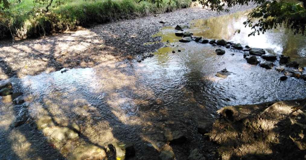
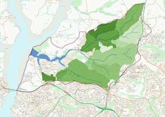
PRK Reaches
The map shows the numbered reaches in the PRK area. For the purposes of the 2017 WRT walkover survey, the Tamerton Stream surface water catchment was divided into three broadly consistent reaches based on the geography, and the nature of the reach, and the pressures exerted upon it.
Reach 1 (Budshead Creek)
Reach 2
Reach 3 (Tamerton Stream)
Mudflats
Ernesettle Creek
Surface water
Reach Locations:
Reach 1 – Berwick Avenue, Crownhill to Budshead Creek.
Reach 2 – Crownhill Fort / Southway (Goodwin Park) to Tamerton Foliot.
Reach 3 – Belliver / Haxter Wood / Porsham to Tamerton Foliot.
Mudflats - Tamerton Foliot to Budshead Creek.
Ernesettle Creek – Tamerton
Lake to land adjacent to Redhill Close.
2
Reference source: Tamerton Stream and Budshead Creek Walkover Survey, Westcountry Rivers Trust (March 2017)
2017 Walkover Survey – Fisheries Habitat
A walkover survey was undertaken in 2017 by the WRT Fisheries Team.
This map shows where the various types of fisheries habitats are found within the project area.
Reach 3
Reaches 1 and 2
Culvert
Bedrock
Chute
Fry
Glide
Modified Channel Parr
Pool
Silted Spawning
Spawning
Reach 1 – Fry habitat was the most common habitat in Reach 1, broken in places by chutes and glides with a small amount of parr habitat near the normal tidal limit (NTL), providing sanctuary for territorial salmonids.
Reach 2 – The fisheries habitat in Reach 2 was more diverse than in Reach 1, alternating parr and fry habitat in many places. However, the habitat was heavily shaded which may negatively impact on the productivity of the Reach.
Reach 3 – The fisheries habitat in the upper section of Reach 3 was fairly uniform fry habitat. In contrast, the lower section offers a combination of fry, parr, glides and pools. The habitat in this Reach was also heavily shaded.
Mudflats - The habitat below the NTL was typical of a muddy estuary, with mudflats, glides from the NTL downwards and no overshading due to the extensive channel width.
Reference source: Tamerton Stream and Budshead Creek Walkover Survey, Westcountry Rivers Trust (March 2017)
3
2017 Walkover Survey – Bankside Habitat
A walkover survey was undertaken in 2017 by the WRT Fisheries Team.
This map shows where the various types of bankside habitats are found within the project area.
Reach 3
Culvert
Bank Erosion
Bankside Fencing
Revetment
Shaded
Tunnelled Vegetation (abandoned coppice)
Tunnelled Vegetation (standards)
Reaches 1 and 2
Reference source: Tamerton Stream and Budshead Creek Walkover Survey, Westcountry Rivers Trust (March 2017)
Rivers and streams need an adequate supply of sunlight to support primary production and their complex food web. Heavy shading and tunnelling can therefore impact the in-stream biodiversity.
Our 2017 survey found that all of the reaches are over shaded and would benefit from targeted coppicing.
4
Water Quality Monitoring
Monthly Spot Sampling Surveys
• Westcountry Rivers Trust Water Monitoring Team carried out monthly spot sampling surveys for 12 months (November 2020 to October 2021) to establish baseline water quality data.
• The 11 sampling sites were carefully chosen to monitor the main rivers and their tributaries.
• Agricultural, waste-water and residential influences were captured.
• Water quality monitoring measured:
• Temperature
• Electrical conductivity
• Turbidity
• Suspended sediment
• Colour
• Phosphates
• Dissolved oxygen saturation
• Dissolved oxygen concentration
• Colour dissolved organic matter (CDOM)
• Optical brightening agents (OBA)
• A summary of the water quality monitoring results can be found on the following pages.
• Full water monitoring results can be found in ‘Water Quality Monitoring Scorecard: November 2020 – October 2021’.
Reference source: Plymouth River Keepers Water Quality Monitoring Scorecard (November 2020 – October 2021), Westcountry Rivers Trust (November 2021)
5
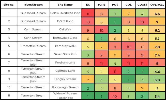
Water Quality Monitoring
Individual Parameter Scores and Overall Water Quality Scores
The table below shows how the overall scores for the subcatchments were calculated. Overall water quality was calculated using the average of the scores given for each basic water quality indicator; conductivity (EC), phosphate (PO4), colour (COL), sediment (TURB) and colour dissolved organic matter (C-DOM). Because C-DOM and OBA (optical brightening agents) tend to score the same, OBA was not included here in the calculation for overall water quality scores so as not to bias the overall score towards the fluorescence.
Overall Water Quality Score (November 2020 - October 2021)
Higher water quality
Lower water quality
The Tamerton Stream at Porsham Lane (Site 7) received the lowest overall water quality score, with Budshead Stream (Site 2), Ernesettle Stream (Site 5) and the Tamerton Stream at the Seven Stars Pub (Site 6) also receiving low overall scores.
6
2020 – October 2021), Westcountry Rivers Trust (November 2021)
Reference source: Plymouth River Keepers Water Quality Monitoring Scorecard (November
PO4
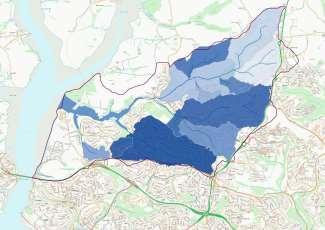
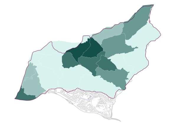
Water Quality Monitoring – Individual Parameter Scores
The maps show the individual parameter scores for each of the subcatchments.
The overall water quality scores for each subcatchment can be found on the next page.
Reference source: Plymouth River Keepers Water Quality Monitoring Scorecard
The darker shades in the maps indicate lower water quality and the lighter shades indicate higher water quality.
Where no colour is indicated, no data was collected for these areas.
7
Phosphate Colour dissolved organic matter Turbidity Colour
Conductivity
(November 2020 – October 2021), Westcountry Rivers Trust (November 2021)
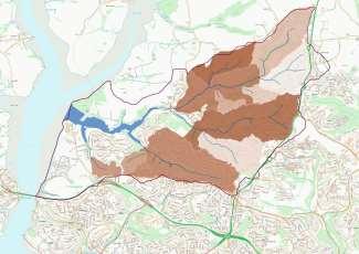
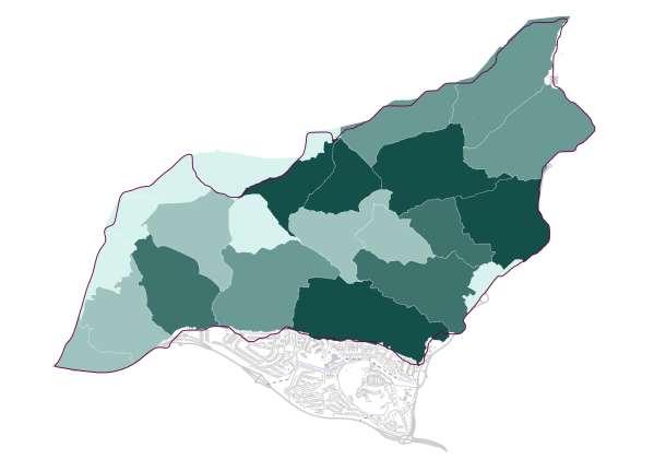
Water Quality Monitoring – Overall Water Quality Score
The map shows the overall water quality scores for each subcatchment.
Tamerton Stream Catchment
Overall
The Watershed tool in ArcMap GIS was used to delineate the subcatchments that represented each sampling site and a colour scale was used to represent the overall water quality score of each subcatchment.
Reference source: Plymouth River Keepers Water Quality Monitoring Scorecard (November 2020 – October 2021), Westcountry Rivers Trust (November 2021)
8
Water Quality Score (November 2020 - October 2021)
! WRT Sample Sites Higher water quality Lower water quality
Water Quality Monitoring
Spot Sampling Conclusions and Observations
• Spot sampling has shown high levels of phosphate at all sites, particularly during low water levels during the summer.
• Evidence of ‘grey water’ and sewage was frequently observed. High levels of optical brightening agents (OBAs) indicate drainage misconnections, e.g., laundry detergents.
• Throughout the catchment there are issues with drainage misconnections and surface water outfalls, as evidenced by the smell, visual observations and water quality results.
• Oxygen levels were noted to be satisfactory, with the exception of the sampling undertaken in September 2021 on the Budshead Stream, when the oxygen level was recorded as low.
• Ammonia was detected on one sampling visit in September 2021. Levels were recorded at 0.5 ppm at Site 6 (Tamerton Foliot, Seven Stars pub) and 3 ppm on the Budshead Stream. The level of 3 ppm is considered to be very high, but the level of 0.5 ppm is still considered sufficient to show human input.
• The low oxygen level and the presence of ammonia recorded on the September sampling visit correlated to a known pollution incident.
• Low levels of turbidity and colour were recorded, with the exception of the sampling undertaken in September 2021 where high turbidity and sediment values were recorded at Site 6 (Tamerton Foliot, Seven Stars pub). This was not considered to be related to the pollution incident referred to above.
• Litter and flytipping is also considered to be having a negative impact on the catchment. Litter was observed at 8 of the 11 sampling sites and observed 92 times during the 12-month sampling period.
Reference source: Plymouth River Keepers Water Quality Monitoring Scorecard (November 2020 – October 2021), Westcountry Rivers Trust (November 2021)
9
Water Quality Monitoring
Static Data Logger and Timelapse Cameras
• Over the course of the project, three trail cameras were deployed over four sites within the catchment (see page 13 for locations).
1. Riverside Walk
• In February 2021, a trail camera was deployed in Riverside Walk. The camera was set to take a photograph every 15 minutes to provide visual data of the streams during daylight hours. The camera temporarily also had a motion sensor to capture wildlife.
• From July 2021 to November 2022, the camera was paired with an Aqua TROLL 200 sonde (a static data logger) which captured data on water depth, temperature and electrical conductivity. The sonde was connected to a Mace telemetry unit, which sent this data to the HydroVu website every 15 minutes which could be viewed by the community.
• The sonde was set to trigger an alarm (received by WRT staff) if the conductivity exceeded 310 µS/cm, a level which may indicate a pollution incident has occurred. This figure was based on analysis of conductivity data from the PRK water quality monitoring, which showed a median value of 292 µS/cm. The sonde alarm was triggered on several occasions, although on a number of these occasions the conductivity was only marginally over the trigger level so this may not have been significant. On each occasion the alarm was triggered, a CSI volunteer or local River Keeper was contacted and either undertook a Westcountry CSI survey or made a visual assessment of the stream on behalf of WRT.
• The trail camera and sonde data were matched up to 15 minute rain data from a local rain gauge at Crownhill, approximately 2.5km away, to determine how rainfall affects the stream due to pollutants such as road run-off from the local area, and soil from higher up the catchment entering the watercourse.
• Further information on the Riverside Walk monitoring can be found in the WRT report ‘Tamerton Foliot Sonde and Trail Camera Data – July 2021 to November 2022’ (published January 2023).
10
Water Quality Monitoring –
Static Data Logger
Riverside Walk Sonde – Example of data
The results from the Riverside Walk sonde and trail camera indicate that two separate types of incidents are occurring in the Tamerton Stream:
1) Unexplained fluctuations in electrical conductivity recorded by the sonde, not accompanied by any visual changes;
2) Visible flushed plumes recorded by the trail camera which do not correlate with the dates/times of the fluctuations in the electrical conductivity.

2021-12-15
2021-12-15
2021-12-17 06:00
2021-12-17 12:30
2021-12-17 19:00
2021-12-18 01:30
2021-12-18 08:00
2021-12-18 14:30
2021-12-18 21:00
2021-12-19 03:30
2021-12-19 10:00
2021-12-19 16:30
2021-12-19 23:00
2021-12-20 05:30
2021-12-20 12:00
2021-12-20 18:30
2021-12-21 01:00
2021-12-21 07:30
2021-12-21 14:00
2021-12-21 20:30
2021-12-22 03:00
2021-12-22 09:30
2021-12-22 16:00
2021-12-22 22:30
2021-12-23 05:00
2021-12-23 11:30
Friday 17th – Monday 20th December 2021 Event
Between approximately 15:15 on Friday 17th December and 13:00 on Monday 20th December (the weekend before Christmas week), specific conductivity fluctuated, with four peaks:
• 300.60 µS/cm at 16:00 17th December
• 318.61 µS/cm at 12:30 18th December
• 320.00 µS/cm at 12:30 on 19th December
• 302.89 µS/cm at 11:15 on 20th December
Prior to these fluctuations the specific conductivity had been relatively stable around 260.00 µS/cm.
There had been little rainfall in the days preceeding the fluctuations, with 0.2mm falling on Tuesday 14th December at 12:45 and no further rainfall until 19:00 on Wednesday 22nd December (0.2mm).
There are no trail camera photographs from these dates.
Spring tide was on Tuesday 21st December (high tide 06:55 & 19:16). High tides on 17th were at 04:27 (5.18m) & 16:45 (5.14m), on 18th were 05:07 (5.32m) & 17:26 (5.21m), on 19th 05:44 (5.41m) & 18:04 (5.24m) and on 20th 06:21 (5.45m) & 18:41 (5.22m).
The reason for the conductivity spikes is undetermined.
0 50 100 150 200 250 300 350 0 0.2 0.4 0.6 0.8 1 1.2 2021-12-14 00:00 2021-12-14 06:30 2021-12-14 13:00
19:30 2021-12-15
2021-12-14
02:00 2021-12-15 08:30
15:00
21:30
10:30
17:00
2021-12-16 04:00 2021-12-16
2021-12-16
2021-12-16 23:30
Series1 Series2 Series3 11
2021-12-23 18:00 Depth (mm) / Spec. Cond (µS/cm ) Rainfall (mm) Date / Time
Water Quality Monitoring
–
Trail Cameras
2. Church Row Lane
• In July 2022, a trail camera was deployed upstream of the Riverside Walk camera and sonde in a bid to determine the direction of the source of repeated visible flushed plumes, i.e. if the source was from the Tamerton Stream or the Whitleigh/Cann stream.
• The visible flushed plumes were visible on the photographs at Church Row Lane which confirmed that the source originated from the Tamerton Stream.
3. Widewell Woods Confluence
• Following the confirmation of the visible flushed plumes originating from the Tamerton Stream, in July 2023 to November 2023 a trail camera was deployed in Widewell Woods to narrow down the location of the source.
• No visible flushed plumes matching those seen at Church Row Lane and Riverside Walk were identified.
4. Widewell Woods North
• In July 2023 a trail camera was deployed upstream of a confluence on the Tamerton Stream to determine from which reach of the stream the visible flushed plumes originated. The trail camera remained in situ for two weeks.
• No visible flushed plumes matching those seen at Church Row Lane and Riverside Walk were identified.
• Wildlife captured on the trail cameras included grey heron (Ardea cinerea), little egret (Egretta garzetta), wood pigeon (Columba palumbus), grey squirrel (Sciurus carolinensis), mallards (Anas platyrhynchos) and domestic mallards (Anas platyrhynchos domesticus), magpie (Pica pica), robin (Erithacus rubecula), blackbird (Turdus merula), pied wagtail (Motacilla alba), chaffinch (Fringilla coelebs), black cap (Sylvia atricapilla) and great tit (Parus major).
12
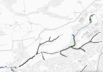
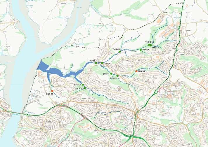
Water Quality Monitoring - Static Data Logger & Timelapse Cameras
The map shows the locations of the trail cameras and sonde.
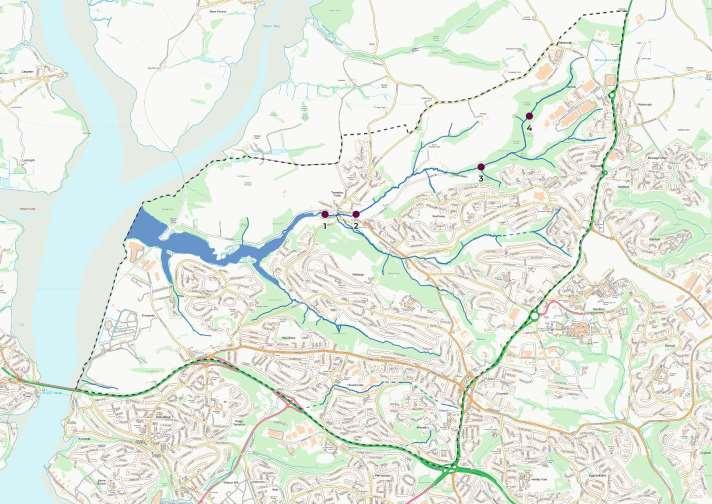
! ( Trail Camera & Sonde Locations
Trail Camera & Sonde Locations
1 – Riverside Walk (camera and sonde)
2 – Church Row Lane
3 – Widewell Woods Confluence
4 – Widewell Woods North
Three trail cameras were deployed in four locations over the course of the project.
A sonde (a static data logger) was deployed at Riverside Walk, paired with a trail camera.
13
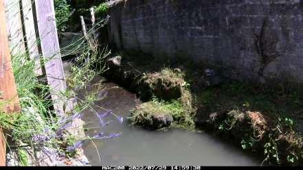
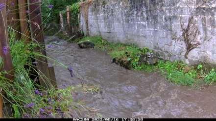
Water Quality Monitoring – Riverside Walk Trail Camera
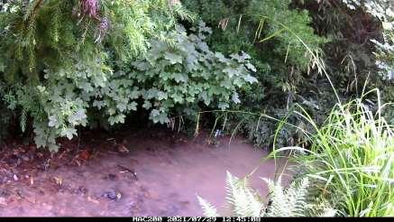
The photographs below show some examples of how the stream changes depending on rainfall, drought or flushed plumes.
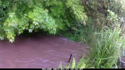
High, brown water caused by soil run-off during heavy rain.
Unidentified flushed plume, seen repeatedly.
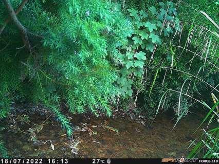
Low water depth in July 2022 (0.08m).
14
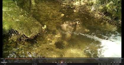
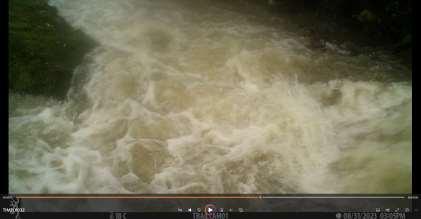
Water Quality Monitoring – Church Row Lane Trail Camera
The photographs below show some examples of how the stream changes depending on rainfall, drought or
 Typical view
Unidentified flushed plume, seen repeatedly.
Typical view
Unidentified flushed plume, seen repeatedly.
15
High brown water following rainfall, flooded bank.
flushed plumes.
Water Quality Monitoring – Trail Cameras
Widewell Woods Confluence
 Typical view
16
Typical view High brown water following rainfall
Widewell Woods North
Water Quality Monitoring –
Conclusions from Trail Cameras
The trail cameras at Riverside Walk and Church Row Lane have repeatedly shown the presence of visible flushed plumes. The plumes have a whiteish tinge and move very quickly through the stream, sometimes being visible on the trail camera photographs for only one or two frames (one photograph is taken every 15 minutes). The plumes are therefore very distinctive and are assumed to come from a single source repeatedly, upstream of Church Row Lane.
No visible flushed plumes were identified on the trail camera photographs at Widewell Woods Confluence and Widewell Woods North. The photographs from all trail cameras were analysed. In addition, the dates/times when flushed plumes were seen in the Tamerton Stream on the two downstream cameras were double checked against the two upstream cameras to ensure that the plumes had not been missed during analysis. The photographs are taken every 15 minutes so there is a possibility that the flushed plumes could have occurred between the photographs being taken and therefore not recorded. However, given the frequency of the plumes being identified on the two downstream trail cameras this is considered unlikely.
It has therefore been concluded that the source of the flushed plumes is very likely to be on the section of the Tamerton Stream between Church Row Lane and the Widewell Woods Confluence (between points 2 and 3 on the map on page 13). Several confluences are present on this section of the stream and further investigations would be required to determine a more precise source of the flushed plumes.
17
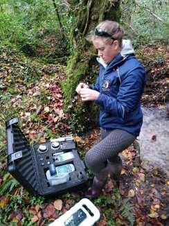
Water Quality Monitoring –
Invertebrate Sampling

Invertebrate sampling was carried out using the Riverfly Partnerships’ ARMI (Anglers’ Riverfly Monitoring Initiative) methodology. This method comprises a 3-minute kick sample followed by a 1-minute hand search. This method was chosen so that it can be replicated by volunteers.
! Riverfly Monitoring Point
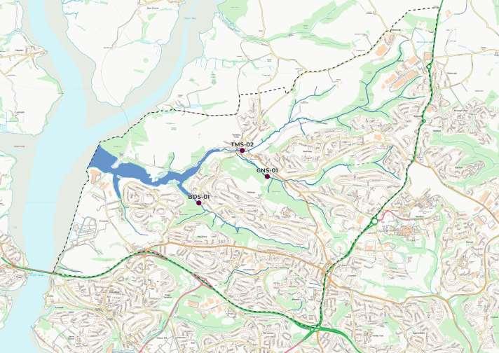
Three Riverfly monitoring points have been identified: BDS-01(U/S), CNS-01 and TMS-02.
Two samples were taken at each of the three Riverfly sites during 2021. This was to establish a baseline to aid in assigning a trigger level.
The trigger level is the baseline score given to a waterbody. After collecting a sample, if the score (determined from numbers of species collected during sampling) is above the trigger level then the stream health is satisfactory, and no action is needed. If the score is below the trigger level the site must be resampled and, if still below the trigger level, the local Riverfly Coordinator and the Environment Agency should be informed.
Reference source: Plymouth River Keepers Water Quality Monitoring Scorecard (November 2020 – October 2021), Westcountry Rivers Trust (November 2021)
18
Water Quality Monitoring – Invertebrate Sampling
Preliminary Results
• After consultation with the Environment Agency ecology lead, it was determined that sites CNS-01 and TMS-02 should both have a trigger level of 7 and site BDS-01 (U/S) should have a trigger level of 4.
• At site BDS-01, an initial kick sample on 24th April 2021 was taken downstream (D/S) of a constantly discharging pipe. The score was extremely low (see BDS-01 in the table below), suspected to be due to the pipe discharge. It was therefore decided that all future samples should be taken upstream (U/S) of the discharging pipe to discount its effects on the invertebrate population. The score of 4 recorded on the second survey for Site BDS-01 (U/S) is still very low, indicating that the stream is receiving pollutants which decrease the diversity of the invertebrate populations. It was also noted that there were leeches and bloodworms present in the sample which are pollution tolerant species.
• All other sites had good diversity and abundance of the eight Riverfly species (see Sites CNS-01 and TMS-02 in the tables below). Site TMS-02 in March showed the highest abundance and diversity of species of all kick samples taken.
• It was not possible to undertake monthly kick-sampling surveys due to time constraints.
Reference source: Plymouth River Keepers Water Quality Monitoring Scorecard (November 2020 – October 2021), Westcountry Rivers Trust (November 2021)
19 Tamerton Stream @ Seven Stars Pub 16-Mar-21 Score 24-Aug21 Score Cased Caddis 5 1 1 1 Caseless Caddis 9 1 2 1 True Mayfly (Epherimedae) 8 1 Flat Bodied Mayfly 6 1 Olive Mayfly 0 20 2 Blue-winged Olive Mayfly 65 2 1 1 Stonefly 15 2 45 2 Gammarus 40 2 6 1 Total 148 10 75 8 Budshead Stream below overhead pipe 24-Apr21 Score 26-Jul-21 Score Cased Caddis 1 1
Caddis True Mayfly (Epherimedae) Flat Bodied Mayfly Olive Mayfly Blue-winged Olive Mayfly Stonefly 8 1 Gammarus 2 1 12 2 Total 2 1 21 4 BDS-01 Cann Stream @ Old Weir 23-Jun-21 Score 24-Sept21 Score Cased Caddis 5 1 Caseless Caddis 1 1 True Mayfly (Epherimedae) Flat Bodied Mayfly Olive Mayfly 25 2 25 2 Blue-winged Olive Mayfly Stonefly 40 2 30 2 Gammarus 30 2 10 2 Total 100 7 66 7 TMS-02 CNS-01
Caseless
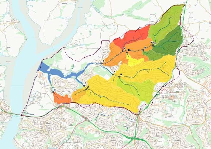
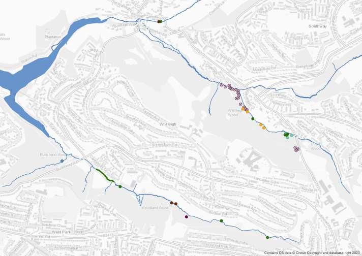
Electrofishing Surveys – Locations
The map below shows the locations of the electrofishing surveys 2021 –
2023.
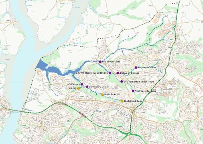
Electrofishing Survey Sites
Survey Year ! ( 2021 ! 2021 - 2023
Survey sites were selected based on areas earmarked for potential fisheries improvements.
In 2021, all eleven sites selected were surveyed.
In 2022, eight sites were surveyed. Three sites were unable to be surveyed due to such low flows following a dry summer, with the headwaters of these streams becoming very shallow and small. Coupled with high temperatures, surveying at times of severe low flow increases risk of damage to fish health.
In 2023, eight sites were surveyed in line with the 2022 surveys.
Reference source: Plymouth River Keepers Electrofishing Fry Index Survey, Westcountry Rivers Trust (October 2021 & January 2023), PRK EF 2023
20
Electrofishing Surveys - Summary
• WRT carried out timed semi-quantitative salmon and trout fry index electrofishing surveys, in addition to presence/absence electrofishing surveys for European eel.
• Eleven sites were surveyed in 2021, and 8 sites were surveyed in 2022 and 2023. It was not possible to survey all sites in 2022 due to low flows and high temperatures which can increase the risk of damage to fish health during electrofishing surveys. In 2023, the sites surveyed in 2022 were repeated.
• The surveys (particularly in 2021) demonstrate that the small streams within the PRK project area have the potential to support excellent salmonid spawning and the importance of these small streams to salmonids (see map on page 23).
• Salmon (Salmo salar) were absent from all sites in all years.
• Brown trout were present at 4 sites in 2021 (with a total of 139 trout fry across all sites), 3 sites in 2022 (a total of 49 trout fry) and 2 sites in 2023 (a total of 7 trout fry) with numbers of fry decreasing each year. In 2021, where trout fry were present, it was in relatively good numbers, with one site (D/S Whitleigh Wood bridge) achieving an excellent classification with 75 fry and 11 parr being recorded within the 5 minute survey.
• European eel (Anguilla Anguilla) were present at 5 sites in 2021, 2 sites in 2022 and 4 sites in 2023.
• It should be noted that summer 2022 was the driest since 1995 and the second hottest on record. In addition, the winter of 2022/23 was relatively dry. These conditions may have potentially reduced the success of spawning, in turn leading to poor recruitment in following years. It is also possible that due to the nature of the streams in the PRK area being small, lower river levels have displaced fish into deeper water or downstream into different river sections or natural variation dictates that it is a less productive year for fry recruitment. Although the absence of eel may appear discouraging, eel can inhabit many different habitat types and so they are not only found in juvenile salmonid habitat, which were the primary focus of the electrofishing surveys. Due to the urban nature of the PRK streams, they do suffer from point source pollution incidents which may impact long term survival for fish. In addition, all reaches have numerous instream barriers present which all have a varying degree of impacting free migration upstream and downstream.
• It should be noted that, based on WRT electrofishing surveys, fish numbers have been lower than previous years across all catchments surveyed by WRT in 2023.
Reference source: Plymouth River Keepers Electrofishing Fry Index Survey, Westcountry Rivers Trust (October 2021 & January 2023) & PRK EF Surveys 2023
21
Electrofishing Surveys – Summary (continued)
• Reach 1 received the lowest classification for trout (absent at sites surveyed), with no trout caught throughout its entire length in any year, with only eel present in the lowest of sites in 2021 and 2022. There are two significant barriers in the form of pipe culverts in the lower section of the stream and directly above the lowest site where eel were identified. The data would suggest that these are impacting passage of both trout and eel. This is further strengthened by data already acquired by the PRK project SNIFFER surveys conducted on these structures, which have indicated that they likely present a complete obstacle to all fish species and all life stages (see page 27-36).
• Reach 2 performed the best; with trout and eel being recorded at a number of sites surveyed. There were some good sections of habitat present along this reach with dappled light, tree roots and refuge established along the banks, with deeper pool sections present to hold larger numbers of fish. Again, a pipe culvert was present on the more northerly section of the stream as it forked off from the main stream and this is where all fish species were found to be absent.
Structure assessments (SNIFFER surveys and the Options Appraisal) support that this pipe culvert is a complete obstacle to all fish species and life stages and would support the lack of fish present in this section. Further man-made structures are present along this section further increasing the likelihood of impediment to fish passage.
• Reach 3 Unfortunately, due to landowner permission not being obtained, only one site was surveyed at lower end of Reach 3, but this site did produce good numbers of trout in 2021 (23 fry and 3 parr) and 2022 (13 fry and 0 parr), with low numbers in 2023 (1 fry and 6 parr). Eel were present in 2021 and 2023. Habitat upstream also appears to be of good quality and would suggest the possibility of trout also being present in this section, dependant on any barriers present.
• In addition to certain structures limiting the free passage of fish to access better quality habitat and spawning areas, some of the areas of these small streams really lacked quality habitat to support the basic needs of many fish species. Long areas of these streams were completely tunnelled and shaded and suffered with high levels of siltation in places. Furthermore, water quality has been an issue in the area due to pollution incidents and run off. See page 25-26 for recommendations for conservation strategies.
Reference source: Plymouth River Keepers Electrofishing Fry Index Survey, Westcountry Rivers Trust (October 2021 & January 2023), PRK EF 2023
22
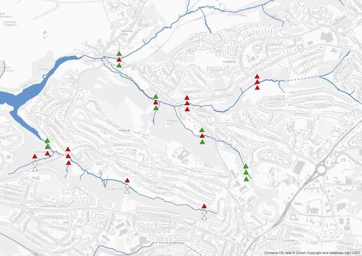
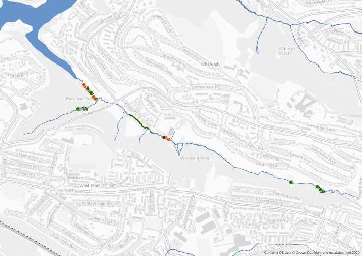
Electrofishing Surveys – Trout Classification
The map below shows the trout classification based on electrofishing surveys in 2021 to 2023.
The surveys were semi-quantitative and the results were classified according to the methodology of Crozier and Kennedy (1994).
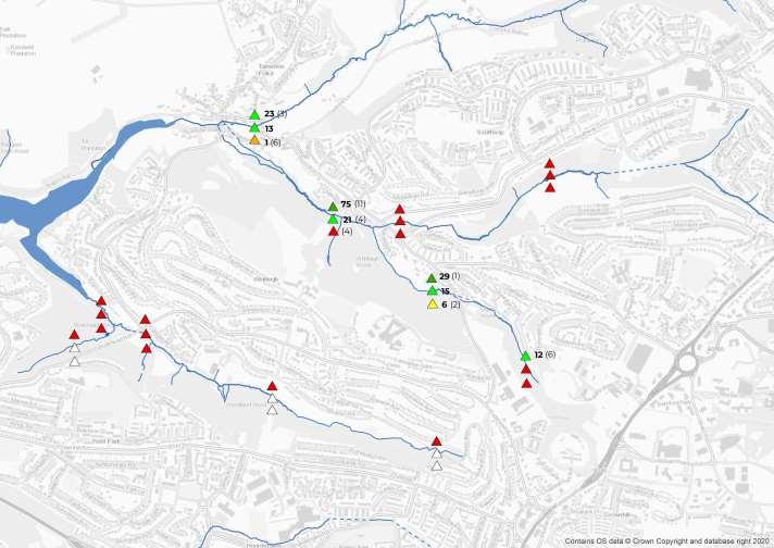
The numbers on the map in bold indicate the number of trout fry identified during the survey, on which the classification is based.
The numbers in brackets indicate the number of trout parr identified.
Reference source: Plymouth River Keepers Electrofishing Fry Index Survey, Westcountry Rivers Trust (October 2021 & January 2023, PRK EF 2023.
23
2021 2023 2022 Year # * # * # * Trout Classification # * A - Excellent # * B - Good # * C - Fair # * D - Poor # * E - Absent # * No data
Electrofishing Surveys – European Eel (Presence / absence)
The map below shows the presence/absence of European eel based on electrofishing surveys in 2021 to 2023.
Reference source: Plymouth River Keepers Electrofishing Fry Index Survey, Westcountry Rivers Trust (October 2021 & January 2023), PRK EF 2023.
24
2021 2023 2022 Year # * # * # * Eel Presence / Absence # * Absent # * Present # * No data
Electrofishing Surveys – Recommendations
• The strategy for restoration and conservation of sites recommended broadly follows the Defend/Repair/Attack concept (developed by Ronald Campbell, Tweed Foundation). It can be applied on a subcatchment level with recommended fisheries management actions suggested to either improve or maintain salmonid habitat and numbers.
• The aim would be to move all sites from their current position to the Defend category, or to ensure they remain in this status if fish stocks are already good.
Category Status Action
Defend These areas have good fish stocks and habitat. These areas need safeguarding actions to ensure no decline occurs.
Repair These areas have moderate fish stocks, and fish habitat in a moderate condition. These areas need assisted habitat recovery to move them into the Defend category.
Attack These areas have poor fish stocks, and the habitat is significantly degraded. These areas need drastic intervention such as habitat reengineering in order to improve their status.
Subcatchment
Reach
Maintain bag limits
Habitat safeguarding
Catch and release
Assisted habitat recovery
Stock action
Habitat re-engineering
Reach
Average Fry Index Class & Conservation Strategy Salmon
The table to the right shows the Plymouth River Keepers subcatchment classification and Defend/Repair/Attack strategy (based on 2021 & 2022 surveys).
Despite excellent trout fry populations in some areas, it is important that defence strategies are put in place to maintain good recruitment and to restore numbers elsewhere in the project area. In all areas, salmon are absent, then the attack strategy and appropriate actions should be implemented where funding allows. Therefore, management strategies need to be considered for each species, hence a conservation strategy for both salmon and trout.
25
Trout
1 Absent Attack Absent Attack
2 Absent Attack Absent Attack
3 Absent Attack Good Defend
Reach
source: Plymouth River Keepers Electrofishing Fry Index Survey, Westcountry Rivers Trust (October 2021 & January 2023), PRK EF 2023
Reference
Electrofishing Surveys – Recommendations (continued)
• To begin to restore and/or maintain fry habitat in the PRK project area, WRT have undertaken the following works:
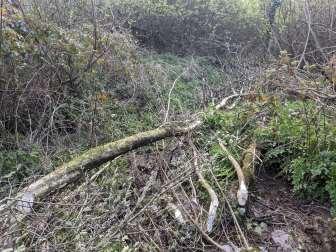
• Coppicing: Targeted selective coppicing of woodland and abandoned riparian coppice adjacent to juvenile habitat riffles. This will increase primary productivity and food source for juvenile fish. Shade should be maintained on deeper pools and runs for water temperature and adult fish habitat cover.
• Fish Passage Assessment: SNIFFER surveys to assess the impact of in-channel structures on migration. This was followed by an optioneering and prioritisation study for 12 barriers in Reach 2 (see page 36).
• In-Channel Habitat Restoration: Installation and construction of habitat enhancing features, including woody debris and brash bundle introduction, flow manipulation with flow deflectors and leaky dams.
• To begin to restore and/or maintain fry habitat in the PRK project area, WRT recommend the following works:
• Erosion Control: Fencing and effective marginal habitat management will reduce erosion. However, where specific areas of high pressure and vulnerability are identified, erosion protection measures such as woody debris installation, environmentally sensitive revetments, and strategic tree planting would be advantageous.
• Further In-Channel Habitat Restoration: Bank reprofiling for marginal zonation, strategic tree planting, gravel introduction and riffle creation, and historic channel restoration. Advanced management usually applied post success of other recommended actions.
• Interpretation: Sensitive spawning sites can be exposed to disturbance at key times of year. Interpretation can be used to inform of salmonid presence and advise on in-river site avoidance.
• Increase monitoring effort: By increasing survey effort, more information on whole catchment performance can be achieved. Increased surveys could include redd (spawning bed) counts, invertebrate monitoring e.g., Riverfly and Westcountry CSI.
Reference source: Plymouth River Keepers Electrofishing Fry Index Survey, Westcountry Rivers Trust (October 2021 & January 2023), PRK EF 2023
26
Sub-catchment Action Fencing Coppicing Erosion Control Fish Passage Assessment In-channel Habitat Restoration Modify Flow Regime Walkover Surveys Interpretation Increase Monitoring Effort Reach 1 ✓ ✓ ✓ ✓ ✓ Reach 2 ✓ ✓ ✓ ✓ ✓ Reach 3 ✓ ✓ ✓ ✓ ✓
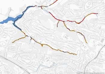
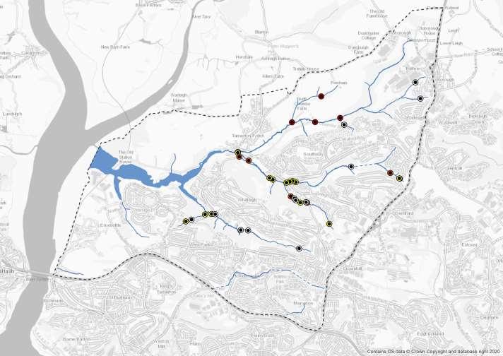
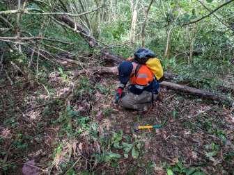
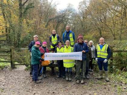
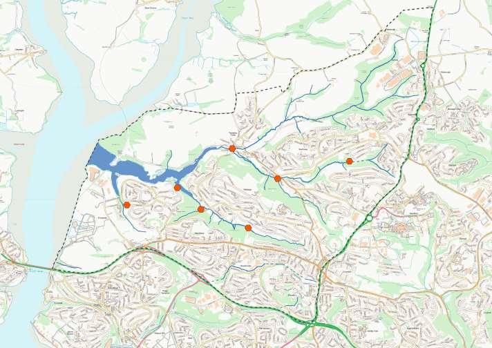
Barriers to Fish Migration Surveys
• An assessment of fish passage for obstructions was conducted following the ‘Coarse resolution rapid assessment methodology to assess obstacles to fish migration(2008)’, developed by the Scotland and Northern Ireland Forum for Environmental Research (these are often referred to as ‘SNIFFER’ surveys).
• The detailed approach of using the protocol allows us to not only judge individual barriers but make an assessment of catchment scale priorities for fish passage solutions. Surveys of the fish migration barriers in our project area helped to determine their impact on the catchment.
• Fifteen in-stream barriers were identified as requiring surveys and categorised into separate reaches (Reaches 1 and 2). These barriers included both box and pipe culverts, boulder barriers, old weirs and rock ramps. All obstacles were surveyed using both SNIFFER and the Zoological Society of London’s (ZSL) Eel Barrier Field Guide protocols in April 2021 during low flow river levels.
• The findings of the survey support that all 15 barriers are having an impact on migration of one or more species. It was highlighted that upstream migration is the most impacted, with many structures being a complete barrier to fish migration. It was found that culvert type obstacles were the worst scoring barriers, with many acting as barriers to upstream migrants.
• The surveys highlighted characteristics of shallow depths and moderate to high velocities were having the biggest impact.
• None of the structures surveyed comply with the current The Eels (England and Wales) Regulations 2009 and it is apparent that mitigation is needed at all sites to help improve passage of these critically endangered species. Where possible removal has been recommended as the best possible option for all species. However, in some cases this is not possible due to the complexity of each structure e.g., where culverts run under large areas of carriageway. In these cases, technical fish passes have been recommended for partial mitigation. It is hoped by addressing migration issues at these barriers, large areas of habitat can be made accessible to all species.
• Full results can be found in ‘Plymouth River Keepers – Fish Passability Assessment’ (December 2021).
Reference source: Plymouth River Keepers Fish Passability Assessment, Westcountry Rivers Trust (June 2021)
27
Barriers to Fish Migration Surveys
The barriers to fish migration identified are shown on the map. There may be additional barriers in the project area that have not been identified.
Reference source: Plymouth River Keepers Fish Passability Assessment, Westcountry Rivers Trust (June 2021)
Obstruction - Survey Type
! P SNIFFER survey not proposed
! P SNIFFER survey proposed, no access
! SNIFFER survey proposed, not yet undertaken
! SNIFFER survey undertaken 2021
SNIFFER surveys look in-depth at barriers (such as weirs) to give expert judgement of its “passability” in terms of different migratory fish species.
During the process many measurements are taken such as head height, flows, depth and transect across the barrier itself.
All this data is inputted into the protocol using a dedicated guidance manual to give a final assessment.
28
Barriers to Fish Migration Surveys
The barriers to fish migration which were subject to surveys in April 2021 are shown on the map.
Reference source: Plymouth River Keepers Fish Passability Assessment, Westcountry Rivers Trust (June 2021)
! SNIFFER survey undertaken (2021)
29
Fish Barrier Survey 2021 – Results (Reach
1 – Adult Trout)
The map shows the upstream and downstream passability scores for each barrier surveyed in April 2021.

Reference source: Plymouth River Keepers Fish Passability Assessment, Westcountry Rivers Trust (June 2021)
Passability Score for Adult Trout (US / DS)
! No barrier / No barrier
! < Partial barrier (low) / No barrier
! Partial barrier (low) / Partial barrier (low)
! Partial barrier (high) / No barrier
! Partial barrier (high) / Partial barrier (low)
! Total barrier / No barrier
! Total barrier / Partial barrier (high)
! Total barrier / Total barrier
The map shows the SNIFFER protocol passability score for adult Trout:
Upstream / Downstream
Partial barrier (low) relates to low impact barrier.
Partial barrier (high) relates to high impact barrier.
30
! < ! <
Fish Barrier Survey 2021 – Results (Reach
2 – Adult Trout)
The map shows the upstream and downstream passability scores for each barrier surveyed in April 2021.

Reference source: Plymouth River Keepers Fish Passability Assessment, Westcountry Rivers Trust (June 2021)
Passability Score for Adult Trout (US / DS)
! No barrier / No barrier
! < Partial barrier (low) / No barrier
! Partial barrier (low) / Partial barrier (low)
! Partial barrier (high) / No barrier
! Partial barrier (high) / Partial barrier (low)
! Total barrier / No barrier
! Total barrier / Partial barrier (high)
! Total barrier / Total barrier
The map shows the SNIFFER protocol passability score for adult Trout: Upstream / Downstream !
31
! <
<
Fish Barrier Survey 2021 – Results (Reach
1 –
Juvenile Eel / Adult Eel)
The map shows the upstream and downstream passability scores for each barrier surveyed in April 2021.
Reference source: Plymouth River Keepers Fish Passability Assessment, Westcountry Rivers Trust (June 2021)
Passability Score for Adult Eels / Juvenile Eels
! < No barrier / No barrier
! No barrier / Total barrier
! < Partial barrier (low) / Partial barrier (low)
! Partial barrier (high) / No barrier
! < Total barrier / No barrier
! Total barrier / Partial barrier (low)
! < Total barrier / Total barrier
The map shows the SNIFFER protocol passability score:
Adult Eel Juvenile Eel Upstream Downstream !
32
< !
Fish Barrier Survey 2021 –
Results (Reach 2 – Juvenile Eel / Adult Eel)
The map shows the upstream and downstream passability scores for each barrier surveyed in April 2021.
Reference source: Plymouth River Keepers Fish Passability Assessment, Westcountry Rivers Trust (June 2021)
Passability Score for Adult Eels / Juvenile Eels
! < No barrier / No barrier
! No barrier / Total barrier
! < Partial barrier (low) / Partial barrier (low)
! Partial barrier (high) / No barrier
! < Total barrier / No barrier
! Total barrier / Partial barrier (low)
! < Total barrier / Total barrier
The map shows the SNIFFER protocol passability score:
Adult Eel Juvenile Eel Upstream Downstream
! < !
33
ZSL Eel Assessment 2021 – Results (Reach 1 – Eel)
The map shows the upstream and downstream passability scores for each barrier surveyed in April 2021.

Reference source: Plymouth River Keepers Fish Passability Assessment, Westcountry Rivers Trust (June 2021)
! Eel Passability Score Range
! ( <05 Likely to be a complete obstacle to eels migrating upstream
! 05-09 Partial impact, obstacle may impede passage
10-15 Unlikely to represent a major barrier to upstream migration
After the initial SNIFFER assessment, a further assessment was carried out using the field guide for eels formulated by the Zoological Society of London (ZSL) intended to provide an eelspecific assessment methodology, hereby referred to as ZSL-Eel assessment. This data allowed the assignment of passability scores as per the scale above.
34
ZSL Eel Assessment 2021 – Results (Reach 2 – Eel)
The map shows the upstream and downstream passability scores for each barrier surveyed in April 2021.
Reference source: Plymouth River Keepers Fish Passability Assessment, Westcountry Rivers Trust (June 2021)
! ( <05 Likely to be a complete obstacle to eels migrating upstream
! 05-09 Partial impact, obstacle may impede passage
! 05-09/ Partial impact, obstacle may impede passage/
! Eel Passability Score Range
10-15 Unlikely to represent a major barrier to upstream migration
10-15 Unlikely to represent a major barrier to upstream migration
The two transversal sections of 2D were assessed independently and each had a different eel passability score, as indicated by the two-tone symbol.
For all other obstacles where more than one transversal section was present, the eel passability score fell within the same range for all sections.
35
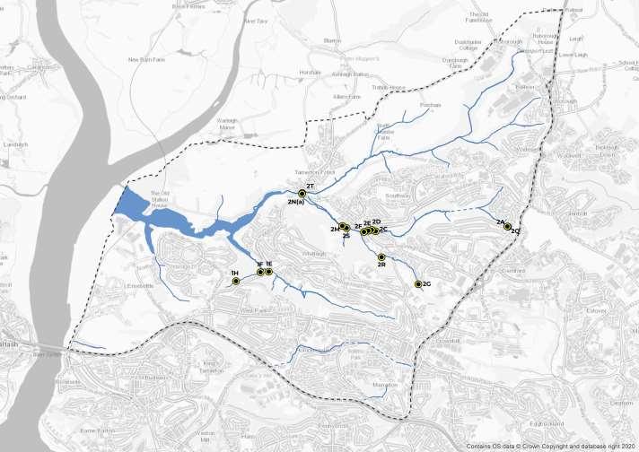
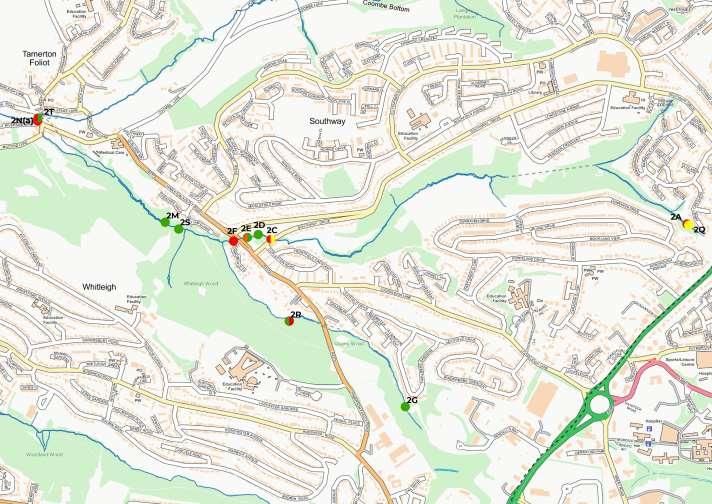
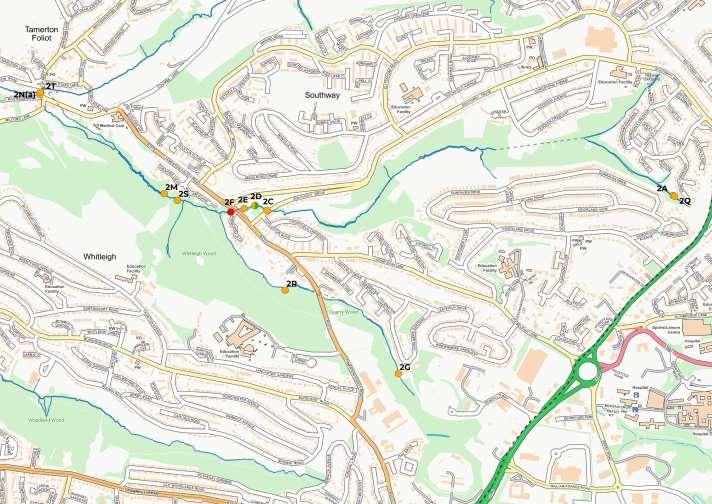
Fish Passage Options Appraisal - Summary
• WRT commissioned an external consultant to undertake an optioneering and prioritization study for 12 barriers on Reach 2 of the PRK project area. Reach 2 was prioritized for the study due to performing the best in the electrofishing surveys and having good sections of habitat already present.
• Each barrier was scored against a set of 8 criteria – habitat gain, distance to next barrier, trout present upstream and downstream, eel present upstream and downstream, passability, buildability and cost. The aim of the work was to help determine which barriers warrant further investigation and possible mitigation work.
• Surveys were undertaken in March 2023 (in low flows) and April 2023 (in high flows).
• Whilst sites 2C and 2D scored highest in terms of priority, it is only recommended they are taken forward if 2F is also mitigated, as this acts as a total barrier to fish passing upstream of Tamerton Foliot road. Similarly, the full benefits would only be realised to 2E if barrier 2F is mitigated. 2N(a) is of next highest priority and would help migratory trout access the river. This barrier is already passable under certain tidal/fluvial conditions but could be improved.
• Barriers 2R, 2A and 2Q were ranked the lowest priority and are not recommended to be mitigated. Despite 2R appearing to be a significant barrier, trout and eel are present upstream. Furthermore, due to the scale of the barrier, mitigation would be very costly for marginal gain. Barriers 2A and 2Q are also substantial and there is little merit in mitigating either, as habitat gain would be very minimal. Currently, there are no fish recorded downstream as these barriers are above sites 2C-2F (which we conclude are priority barriers). Barrier 2S is also low-priority as it is a largely passable natural barrier. Site 2T is a confined space and requires further investigation in order to assess whether the northern reach of the Reach 2 enters this culvert and if the conditions in the culvert itself are detrimental to fish passage.
• The appraisal recommended that sites 2C, 2D, 2E, 2F, 2G, 2M and 2N(a) are taken forward for further investigation. This is based on the criteria used within the prioritisation study and this list may vary subject to stakeholder requirements and budget. Cost estimates used in the scoring are based on small local, specialist contractors and may vary subject to design, investigation, or procurement route. Some of the minor easements could be delivered for lower cost internally at WRT and//or with the use of volunteers.
• Barrier 2F is substantially more expensive to mitigate than the other priority barriers, but is critical in order to allow migratory species access to upstream habitat.
36
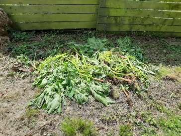
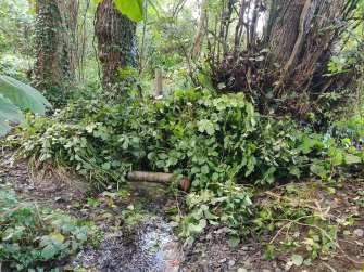
Habitat Improvement Works - Overview
Westcountry Rivers Trusts’ River Operations Team undertook a program of habitat improvement works:
• Installation of 22 leaky dams, 10 flow deflectors and 1 brash feature in Woodland Wood (along 2km of watercourse) and Budshead Wood (along 0.5km of watercourse). This work was undertaken in conjunction with the Plymouth Natural Grid Team (Plymouth City Council / National Trust).
• Coppicing of hazel and sycamore in Woodland Wood to reduce the level of shading along the stream which will allow other native flora to thrive.
• Approximately 250m2 of laurel was removed along approximately 2km of the riparian corridor in Woodland Wood. Ecoplugs were deployed in the laurel stumps to prevent re-growth. The ecoplugs will be removed after 12 months to avoid leaving plastic in the environment.
• Removal of Himalayan Balsam along approximately 0.8km of the stream in Whitleigh Wood (see page 38 for more information).
• Eradication of Water Fern (Azolla filiculoides) from Budshead Pond, with the surface area of the pond affected estimated to be 250m2 (see page 39 for more information).
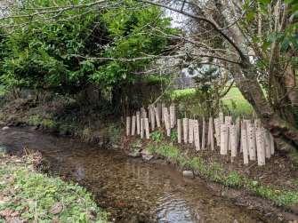
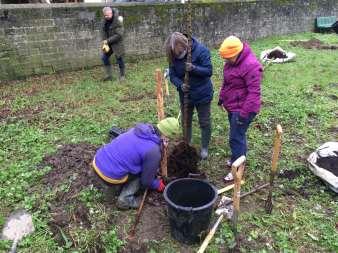
• 5 trees planted, working with community volunteers and local residents on planting days. Three trees (crab apple, field maple and wild cherry) were planted in The Old Playground in Tamerton Foliot. Aftercare will be provided for these trees until the end of summer 2024. Two common alder trees were planted adjacent to the Tamerton Stream in private gardens.
• Working with private homeowners in Seven Stars Lane, 50 hazel whips were planted along the bank of the Tamerton Stream in Wadlands Meadow to infill the hedgerow due to the proposed removal of laurel, improving approximately 0.025km of riparian habitat.
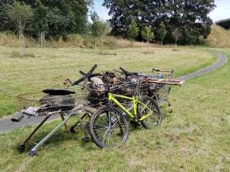
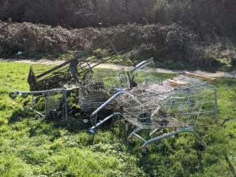
• The removal of anthropogenic trash and wood debris dams through the removal of 29 shopping trolleys from approximately 2km of stream in Woodland Wood, in addition to many other large flytipped items (e.g. car tyres, traffic cones, office chairs, bicycles, child’s ride on car). The anthropogenic litter and flytipping in the stream accumulates additional smaller items of litter and organic matter (such as leaves and branches), creating debris dams which can impede the flow of water and fish migration.
• In total, over 5km of riparian habitat was improved as a result of the program of works undertaken.
37
Habitat Improvement Works –
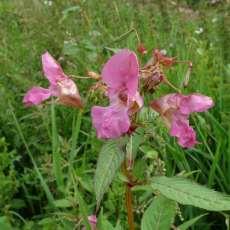
NNIS Control
• Non-native invasive plant species (NNIS) are present throughout the project area, associated with the riparian habitats and surrounding woodlands (see map on page 40).
• Species in the project area listed on the Wildlife & Countryside Act 1981 (Schedule 9) include Himalayan Balsam, Japanese Knotweed, Water Fern and Rhododendron. This means that it is against UK law to cause or allow the plant to spread in the wild.
• NNIS often out-compete native plant species for nutrients, light and space. Some species, e.g., Himalayan Balsam, also outcompete native plants for pollinators which can lead to reduced pollination of native plants, and can destabilise banks due to their shallow root systems.
• Following three seasons of removal (2021 to 2023) of Himalayan Balsam in Whitleigh Wood, no further plants were identified in summer 2023 and it is believed that eradication within the woodland boundary has been achieved. It is not possible to completely remove future risk of reestablishment due to the presence of this species in adjacent residential gardens. However, the residents were contacted via a leaflet drop and door-knocking exercise to inform them of the implications of the plants being present within their gardens, and WRT offered to remove this species from their garden. Residents from one property also attended a Himalayan Balsam removal event to learn more.
• Laurel removal works were undertaken in September 2023 in Woodland Wood, working with the Plymouth Natural Grid project.
• Japanese Knotweed identified by WRT in Woodland Wood was reported to Plymouth City Council and has been added to their NNIS removal schedule.
38
Himalayan Balsam removed from Whitleigh Wood, June 2021
Himalayan Balsam
© Natural England / Peter Roworth - Flickr CC Licence
Habitat Improvement Works – NNIS Control: Water Fern
• In 2021 Water Fern (Azolla filiculoides) was identified in Budshead Pond. Water Fern is a NNIS from the Americas. It spreads rapidly to form a mat on the surface of the water, blocking out light and depleting the water of oxygen. This can harm native wildlife that lives in the pond.
• To control the Water Fern, North American Weevils (Stenopelmus rufinasus) were released into the pond. This is an environmentally friendly way to remove the Water Fern, without using harmful chemicals, or risking spreading the plant further by physical removal. The weevils feed solely on Water Fern and do not impact on any other species.
• 2000 weevils were released into the pond in August 2021, and the Water Fern was completely eradicated by October 2021. The Water Fern has not returned to the pond (as of November 2023).
• To monitor the progress of the weevils, a fixed point photography post was installed at the pond. As of November 2023, 57 photographs have been sent in to WRT. A timelapse video was created to illustrate the eradication of the Water Fern.
Fixed Point Photography Post photographs showing the removal of Water Fern on Budshead Pond, using weevils as biological control.
The photo on the left shows the pond on the day of weevil release on 03/08/2021, the photo on the right shows the pond on 01/12/2021.
39
© Brenda Thorne (CSI Volunteer)
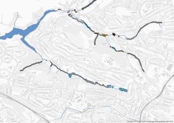
Habitat Improvement Works – NNIS Control
The map shows the known locations of invasive non-native plant species in the project area identified during NNIS surveys, along with locations of NNIS control undertaken.
NNIS Survey & Removal Works
! Bamboo
! ? Himalayan Balsam - removed 2021 & 2022
! Japanese Knotweed
! ( Laurel
Laurel - removed 2023
! Laurel - proposed for removal
! Rhododendron
! Water Fern - removed 2021
! Winter Heliotrope
40
Habitat Improvement works – In-River
Works
The map below shows the approximate locations of in-river habitat works in Budshead Wood and Woodland Wood.
In-River Habitat Works
% Brash Feature
% Flow Deflector
% Leaky Dam
Laurel Removal & Ecoplugs
Type
41
Habitat Improvement Works - Examples
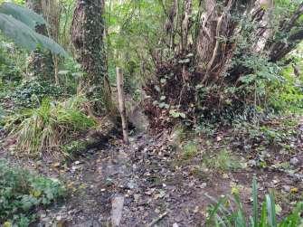
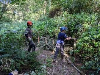
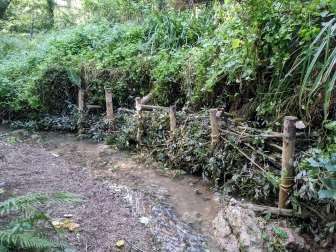
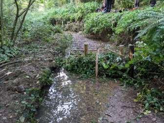
42
Leaky dam - before
Leaky dam - after
Installation of brash feature
Brash feature
Flow deflector
Deployment of ecoplugs on cut laurel stumps
Habitat Improvement Works - Examples
43
Hazel whips planted in Wadlands Meadow
Laying of hazel and willow coppice (farm works)
Volunteer tree planting in The Old Playground Tree planting in The Old Playground Anthropogenic trash removed from the stream Anthropogenic trash removed from the stream
Ernesettle Rainshare
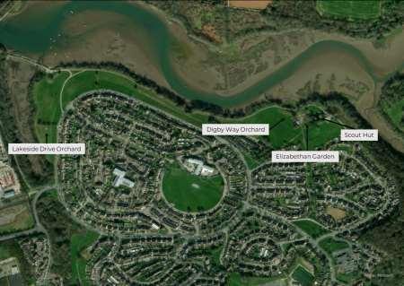
• The Rainshare scheme shares roof run-off from buildings that would otherwise be wasted with people who can utilise this water, for example for gardening and food growing. This saves drinking-quality water from being used for this purpose, providing a sustainable, free fresh water supply, and reduces the amount of rainwater entering the surface water drainage system.
• Ernesettle Rainshare began following a request from the Friends of Ernesettle Creek and Budshead Wood Group about water resourcing for their two community orchards and proposed Elizabethan garden. The orchards have not produced viable fruit in recent years due to drought conditions.
• In October 2023, 2 x 1200L slimline tanks (interconnected) were installed on the northern aspect of the Ernesettle Scout Hut.
• In addition to the rainwater harvesting system itself, the PRK project has provided the Friends Group with a small 180L towable water tank to transport water to the Lakeside Drive orchard approximately 1.3km away, in addition to smaller wheelbarrow water carriers and a hosepipe (which will be gravity fed) to water the Digby Way orchard and Elizabethan Garden without the need for a vehicle. Lockable taps have been provided will help to prevent vandalism.
• The Rainshare equipment has been insured by the Friends Group which shows a commitment on their part to maintain the system and will increase the sustainability of the Rainshare project for years to come.

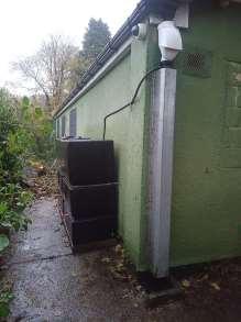
The system has been fitted with a self-cleaning ‘leaf-eater’ filter to prevent leaf litter and debris from entering the water tanks.
Black opaque tanks were used to reduce bacterial growth from sunlight. In addition, the system is located on the northern aspect of the building to increase shading which will also reduce bacterial growth.
These features will help to reduce ongoing maintenance.
44
This map shows the location of the Rainshare system (Scout hut), the two orchards and the proposed Elizabethan garden.
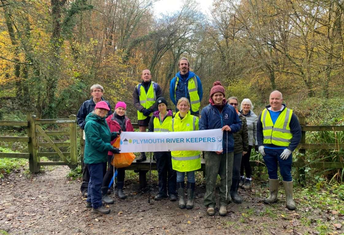
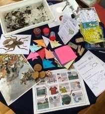
Westcountry Citizen Science Investigations (CSI)
• Westcountry CSI is a volunteer program which aims to educate and engage people with the water environment, to produce data that can be used to target work and identify degrading water bodies, to spot pollution events so that they can be dealt with as quickly as possible and to create a network of catchment communities that are invested in their local environment.
• Over the course of the Plymouth River Keepers project, 135 Westcountry CSI surveys have been carried out over 10 sampling points in the project area, by 5 volunteers (up to 31st October 2023). Westcountry CSI volunteers will continue to be supported beyond the PRK project by the Westcountry CSI Team.
• Westcountry CSI volunteers have participated in extra water quality related surveys at very short notice when required following suspected pollution incidents, for example a fish kill on Budshead Pond (which was attributed to low O2 levels) and high conductivity alerts from the sonde on the Tamerton Stream. This has provided invaluable data for the project and increased volunteer stewardship of the streams.
• A Westcountry CSI volunteer training event was held in November 2021 in Tamerton Foliot. The aim was to increase the uptake of the scheme but was also open to existing volunteers to provide ongoing support. Eight people attended the training, with four signing up to be a CSI volunteer, although none of the attendees signed up to volunteer within the PRK project area.
• The scorecard summaries for the two PRK waterbodies can be found on page 47.

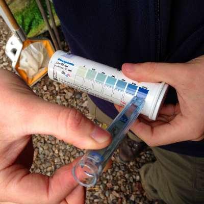
Phosphate testing kit.
© Bioregional Learning Centre
45
Westcountry Citizen Science Investigations (CSI)
The map shows the Westcountry CSI sample points across the catchment, including which sample points have been sampled by volunteers (up to 31st October 2023).
CSI Sampling Points:
Surveyed by Volunteer? ! No ! Yes
Of the 12 sampling points suggested by WRT, 10 have been surveyed by volunteers.
Volunteers have also been free to choose their own sampling point in addition to any of the 12 suggested should they wish.
46
Westcountry CSI Scorecard Summaries
• There are two Westcountry CSI waterbodies in the PRK area – Tamar and Tavy (tidal) and Tamerton Foliot Stream.
• The table below shows the scorecard summaries for 2021 and 2022, calculated using Westcountry CSI data.
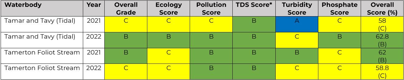
River Health Scale
47
A Excellent 80-100 B Good 60-80 C Fair 40-60 D Poor 20-40 E Very poor 0-20
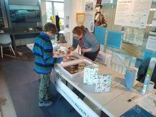
Outfall Safaris
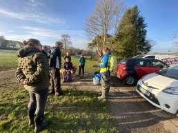
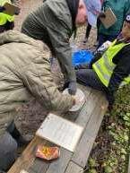
• Outfall safaris followed the methodology developed by The Zoological Society of London and CaBA (Catchment Based Approach).
• Two outfall safari training events were held in Budshead Wood, in December 2022 and February 2023, with 16 people attending across both events.
• The aim of the training was to give the local community the knowledge to recognise misconnected and polluted outfall pipes, and provide a standardised method of reporting this information to the appropriate authority (Environment Agency / South West Water). Once reported, further investigation and remediation work can be undertaken where necessary in a bid to improve water quality across the catchment.
• There are 2 active outfall safari volunteers in the PRK area, with 11 outfalls surveyed (up to 31st October 2023), Whilst the project was in progress, survey results were passed by WRT onto the SWW Misconnections Team for further investigations where necessary.
• Beyond the end of the PRK project, the outfall safari volunteers will be able to continue surveying and follow the established protocol for reporting results where appropriate directly to the Environment Agency and South West Water via their incident hotlines.
48
Outfall safari training session, December 2022
Community Engagement - Online Events
• The Plymouth River Keepers team have hosted a series of online events, including a ‘Roundtable’ event in September 2020, in partnership with the Bioregional Learning Centre, a ‘River Dip’ in September 2020 (a bitesize tour of the project), and a Festive Event in December 2020. These events were open to members of the local community, local organisations and landowners (e.g., Plymouth City Council and Woodland Trust) to meet the team and allow them to find out more about the project. These online events were a valuable way to connect with the community during Covid-19 restrictions.
• Between February and June 2021, the Plymouth River Keepers project collaborated with the Conscious Sisters, a Plymouth-based CIC (community interest company) to run a series of online sessions with the aim to connect people to place. Part of the Conscious Sisters’ ClanKind program, a River Keepers Clan was formed, being centred around Budshead Creek. Sessions included history, foraging, ecology and storytelling. The group met for one in-person session, a drama and dance river connecting session. One member of the group has become a committed Westcountry CSI volunteer, whilst other members have remained connected to the project and have taken on other River Keeper roles, for example reporting pollution incidents, sharing project information with their communities and attending events such as litter picks.
• A total of 45 people engaged with the project via online events.
© The Conscious Sisters
© The Conscious Sisters
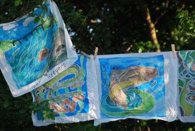
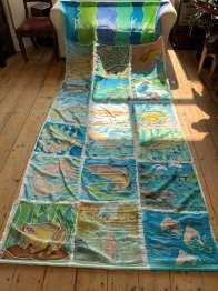
As part of ClanKind, the group created a banner.
Each group member created two silk paintings, depicting animals or landscape scenes from the area on which the Clan was based - Budshead Creek.
49
Community Engagement –
Events
• Over the course of the project, WRT has engaged approximately 830 people from the local community at 34 face-to-face events
. Attendance at WRT-led events was documented using sign-in sheets. Events included:
• Three pop-up events in local green spaces, to provide an informal drop-in for the local community to meet the team and find out more about the project – Ernesettle Green, Southway Valley and Tamerton Foliot Carnival.
• NSPCC Together for Children event, to nurture children's love of nature in a safe and supportive environment.
• An evening talk to Soroptimist International Plymouth and District group.
• Local community events including the Ernesettle Focus Group, Ernesettle Christmas Extravaganza and Christmas lights switch-on, Tameron Foliot Carnival, Ernesettle Coronation Carnival, Ernesettle School fete, Timebank SW 10th anniversary celebration.
• Education stalls at the Tamar Bridge Visitor Centre for Wildlife Week and Marine Wildlife Week.
• Litter picks in conjunction with the Preventing Plastic Pollution project (see page 52-53 for more information).
• Himalayan Balsam removal events in Whitleigh Wood.
• Tree planting in Tamerton Foliot.
• Outfall safaris (see page 48 for more information).

50
Ernesettle
Face-to-Face
Tamar Bridge Visitor Centre Wildlife Week, April 2023.
Pop-up Event, July 2021 NSPCC Together for Children event, August 2021
Plymouth River Keepers in the Community
• Members of the local community have taken on a variety of River Keeper roles, including becoming Westcountry CSI volunteers, attending events such as litter picks and pop-up events, sharing project information and events with their local groups and communities, or taking photographs from our Fixed Point Photography posts. An important River Keeper role is that of reporting pollution incidents and we have members of the community who regularly report incidents to the Environment Agency, in addition to keeping WRT informed of any incidents.
Pollution incidents
• Since the start of the project, WRT have received approximately 40 reports of suspected pollution in the project area. These include:
• Four incidents involving dead fish and/or crabs (one incident on Budshead Pond was later attributed to low O2 levels).
• Sixteen incidents related to sewage and sewage related litter.
• Two incidents relating to SWW Ernesettle Waste Water Treatment Works.
• Three incidents relating to local factories.
• Three incidents relating to works on the highway and/or culverts.
• Six suspected pollution incidents on Tamerton Lake. In two of these Tamerton Lake incidents sanitary items and sewage related litter was observed, and in one incident a large number of dead fish and crabs were observed. It has been reported to us that these Tamerton Lake incidents often occur on the incoming tide. The Environment Agency have attributed a proportion of these incidents to algal bloom.
• Watercourses have been affected by these incidents, in addition to public footpaths and a community orchard.
• These incidents have either been reported to the Environment Agency by the community member or by the PRK project team.
51
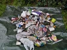
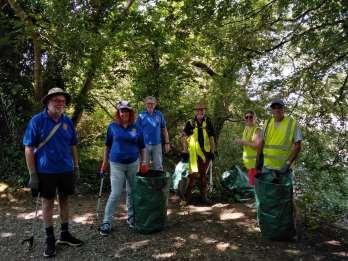
Preventing Plastic Pollution
• Plymouth River Keepers worked in partnership with the Preventing Plastic Pollution project (PPP) in the PRK area.
• Over the course of the project, 16 litter picks and litter surveys were held in the PRK area:
• Sites included Whitleigh Wood, Tamerton Foliot (Riverside Walk), Woodland Wood, Southway Valley, Budshead Pond, Budshead Wood, Ernesettle Creek and Pembrey Walk (Ernesettle). See map on page 53.
• Over the 16 litter picks 93 volunteers* took part, with a combined total of 144 volunteer hours.
• Over 22km of riparian habitat along the streams were cleared of litter and flytipping.
• Approximately 558kg of litter was collected and removed from the environment, including approximately 305kg of plastic.
litter pick, July 2021.
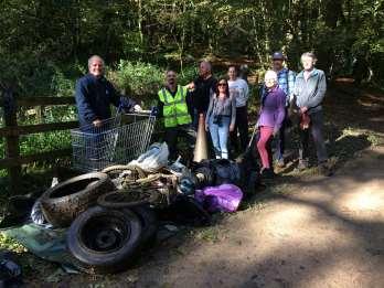
Budshead Pond and Woodland litter pick, October 2021.
* Cumulative volunteer total – some volunteers may have been counted more than once due to attending multiple events.
52
Tamerton Foliot
Litter removed from Whitleigh Wood, June 2021
Preventing Plastic Pollution
The map shows the starting points for the Preventing Plastic Pollution community litter picks.
53
% PPP Litter Pick Starting Points
PRK Communications
Communications were an important part of the project, informing local communities about the project, events and how they could get involved. Below are some examples of these communications:
• A leaflet drop was used to advertise the project to over 13,000 residential properties in the project area, and included an invitation to the online River Dip in September 2020.
• The PRK team have presented the project to the Tamar Catchment Partnership, Ernesettle Forum, Ernesettle Focus Group, Plymouth Residents Preventing Plastic Pollution (at the National Marine Aquarium).
• The Plymouth River Keepers project has been featured in a range of media and publications, including:
• BBC Devon (live interview)
• Radio Plymouth (live interview)
• BBC Spotlight (pre-recorded segment and live interview)
• BBC news webpage
• Plymouth Chronicle (free local newspaper delivered to 92,000 properties)
• Devon Life magazine and webpage
• Timebank SW newsletter (local online newsletter)
• Tamar Valley AONB Newsletter (Spring/Summer 2021 and Spring/Summer 2023)
• Ernesettle Up The Creek magazine (free magazine delivered to every home in Ernesettle)
• Examples of the above publications can be found on the Westcountry Rivers Trust website: https://wrt.org.uk/project/plymouth-river-keepers/
• PRK has featured in the Westcountry Rivers Trust Newsletters 23 times.
• PRK has regularly featured on Westcountry Rivers Trust social media accounts (Instagram / Twitter / Facebook).
• A list of media outputs with online links can be found in the Appendices on page 62.
54
Post-project commitments
Westcountry Rivers Trust agreed an extension with the Environment Agency and South West Water to undertake a program of works beyond the timeframe of the project:
Habitat Works Extension
Wadlands Meadow Laurel Removal:
• Reason: The work was delayed because nesting birds were identified in the laurel when the work was initially scheduled to occur so it needs to be undertaken outside of the bird breeding season.
Ecoplug removal – Woodland Wood:
• Reason: The ecoplugs were deployed in September 2023 and need to remain in situ for 12 months. The ecoplugs need to be removed to avoid leaving plastic in the environment.
• Timeframe: To be completed by Q4 2024
The Old Playground – Tree Aftercare
• Reason: To provide the new trees with the best chance of survival and prevent drought stress etc.
• Activity: Mulching, watering and formative pruning.
• Timeline: Up to Q4 2024
Farm Works Extension
• PRK will undertake further investigations and interventions with two farms in the area, due to delays outside of the control of the project. This work will be completed by the end of Q1 2024.
55
Farm Advice and Interventions

• WRT Farm Advisors worked with farmers and landowners to the north of the Plymouth River Keepers project area. For eligible farms in the area, Farm Advisors offered to undertake a full farm survey and provide a farm plan with an aim to deliver land management advice and on-farm measures to minimise pollutant loss from farms while maximising efficiency & enhancing ecological health.
• Of the farms contacted by WRT, three farms went on to work with our Farm Advisors to deliver a series of interventions.
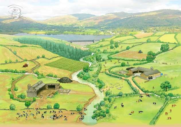
Examples of interventions delivered:
• Pond creation for retention of runoff and sediments and to provide an emergency farm water supply.
• Retention dams to slow ephemeral stream flows and hold water back in high rainfall situations.
• Riparian coppicing to reduce the levels of shading over the streams to increase primary production and encourage the growth of a more diverse range of ground cover species.
• Yard management – new concrete to replace the cracked and broken yard surface, improving yard management, cleanliness and preventing leaching.
• Trough management to prevent poaching.
56
Good Farm, Bad Farm © Brian Hoskins
Flood Risk Impact – NFM Prioritisation Exercise
This map shows ‘subcatchments’ in the wider Tamerton Stream catchment. When targeting measures in a landscape, it is often useful to summarise risk by distinct spatial units, so that patterns for combined impacts can be visualised more clearly. For flood-risk mitigation, a useful spatial unit for this exercise is the hydrological boundary of rivers, streams or other surface water flow pathways.
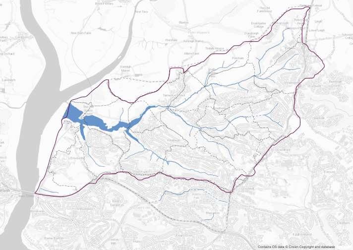
Tamerton Stream Catchment
Subcatchments
The Watershed tool in ArcMap GIS was used to calculate the hydrological catchment of the Tamerton Stream.
For the purposes of the flood risk impact exercise, the Tamerton Stream catchment was divided into smaller ‘subcatchments’ using a more refined watershed dataset created by the University of Exeter (via the SWEEP project). Some of these catchments have been merged or split to create polygons of a similar size.
The potential flood risk (of both surface water flooding and fluvial flooding) was calculated for each of the ‘subcatchments’ for 1 in 100 year rainfall events (see pages 58-61).
This information could be used to prioritise areas for any future potential NFM (Natural Flood Management) interventions.
57
Surface Water Flooding – Infrastructure at Potential Risk
These maps show the extent of surface water flooding for a 1 in 100 year rainfall event, highlighting buildings (over 40m2), roads and agricultural land at potential risk. Surface water flooding occurs when heavy rain falls on hard surfaces, overwhelming the surface water drainage system.
FLOOD ZONES
(1 in 100 year event)
Maximum extent of surface water flooding
Tamerton Stream Catchment
Surface water
ROADS AT RISK
Roads potentially at risk of surface water flooding
BUILDINGS AT RISK
Buildings potentially at risk of surface water flooding !
AGRICULTURAL LAND AT RISK
Agricultural Land
Agricultural land potentially at risk of surface water flooding
58
! ! ! ! ! ! ! ! ! ! ! ! ! ! ! ! ! ! ! ! ! !! ! ! ! ! ! ! ! ! ! ! ! ! ! !! ! ! ! ! !! ! ! !!! !!!! ! !! !! ! ! ! ! ! !!! ! !! ! ! ! ! !! ! ! ! ! ! ! ! !! ! ! ! ! ! ! ! !! ! ! ! !!!! ! ! ! ! ! ! !! ! ! ! ! ! ! ! ! !!! !
Surface Water Flooding – Summarising Flood Risk Impact
The three smaller maps on the right summarise the potential flood risk impact for each of the ‘subcatchments’ within the Tamerton Stream catchment. Each ‘subcatchment’ is given a high-low score for buildings (over 40m2), roads and agricultural land. The map on the left combines these scores to give an overview of combined flood risk impacts.
FLOOD RISK IMPACT SUMMARY
By surface water ‘subcatchment’ BUILDINGS
Tamerton Stream Catchment
59
LAND AT RISK
Potential Flood Risk Impact Score Higher Lower Combined Potential Flood Risk Impact Score Higher Lower
AT RISK ROADS AT RISK AGRICULTURAL
Fluvial Flooding – Infrastructure at Potential Risk
These maps show the extent of fluvial flooding for a 1 in 100 year rainfall event, highlighting buildings (over 40m2), roads and agricultural land at potential risk. Fluvial flooding is flooding from the rivers and streams.
FLOOD ZONES
(1 in 100 year event)
Maximum extent of fluvial flooding
Tamerton Stream Catchment
Surface water
ROADS AT RISK
Roads potentially at risk of fluvial flooding
BUILDINGS AT RISK
Buildings potentially at risk of fluvial flooding !
AGRICULTURAL LAND AT RISK
Agricultural Land
Agricultural land potentially at risk of fluvial flooding
! !! ! ! ! ! !!!!!! ! ! ! !!! ! ! ! ! !! ! ! ! ! ! !! !!
60
Fluvial Flooding – Summarising Flood Risk Impact
The three smaller maps on the right summarise the potential flood risk impact for each of the ‘subcatchments’ within the Tamerton Stream catchment. Each ‘subcatchment’ is given a high-low score for buildings (over 40m2), roads and agricultural land. The map on the left combines these scores to give an overview of combined flood risk impacts.
By surface water ‘subcatchment’ Tamerton Stream Catchment
61
LAND AT RISK Potential Flood Risk Impact Score Higher Lower Combined Potential Flood Risk Impact Score Higher Lower
BUILDINGS AT RISK ROADS AT RISK AGRICULTURAL
FLOOD RISK IMPACT SUMMARY
Appendices - PRK Communications
Below is a list of media outputs with online links (where available).
Westcountry Rivers Trust Newsletters:
• Autumn 2019: https://mailchi.mp/90eb4d23de86/dont-miss-out-on-our-latest-events-and-updates
• July 2020: https://mailchi.mp/d1df4fd4d9c8/wade-in-for-water
• September 2020: https://mailchi.mp/8a0f2d2f5f8e/wade-in-for-water-4799910
• November 2020: https://mailchi.mp/17c53eabc34f/wade-in-for-water-4831394
• December 2020: https://mailchi.mp/83e2c01a0442/wade-in-for-water-4859902
• March 2021: https://mailchi.mp/2cf8e5ff6ab5/putting-spring-in-your-step
• April 2021: https://mailchi.mp/b25a7f208a84/celebrating-our-rivers-during-earth-month5359414
• May 2021: https://mailchi.mp/6bdd8f6caa41/celebrating-our-rivers-during-earth-month5359414-5365902
• June 2021: https://mailchi.mp/be0ec5eb1e89/a-very-busy-month
• July 2021: https://mailchi.mp/091ac4e7866f/can-you-help-5384270
• August 2021: https://mailchi.mp/f459efd0417b/theres-still-time-5391054
• October 2021: https://mailchi.mp/8c28a3afca81/what-we-are-doing-for-rivers-5414934
• January 2022: https://mailchi.mp/ba1db8e0c89f/be-the-voice-of-rivers-7584142
• February 2022: https://mailchi.mp/91ff255b508e/jump-in-to-support-rivers-7888598
• March 2022: https://mailchi.mp/64b823793bd3/a-place-to-call-home-7891882
• April 2022: https://mailchi.mp/5a2db08364b5/a-huge-thank-you-8589905
• May 2022: https://mailchi.mp/51d12590da73/wade-in-this-summer-8635957
• July 2022: https://mailchi.mp/d13a083a60ee/helping-our-rivers-8667047
• August 2022: https://mailchi.mp/f3270cea210b/helping-our-rivers-8668707
62
Appendices - PRK Communications
Westcountry Rivers Trust Newsletters (continued):
• October 2022: https://mailchi.mp/a6828cb8afc2/helping-our-rivers-8673487
• November 2022: https://mailchi.mp/d64769e0c449/helping-our-rivers-8686331
• January 2023: https://mailchi.mp/7a112c16baa4/helping-our-rivers-8850787
• April 2023: https://mailchi.mp/dc94155dace9/bringing-rivers-to-you-8857687
Links to online articles (where available):
2019
• August: South West Water to pay charity £350,000 after polluting stream - GOV.UK (www.gov.uk)
2020:
• June: BBC Radio Devon - JP took part in project intro interview (not available online anymore).
• June: Plymouth Radio PRK interview (no longer available online)
https://www.radioplymouth.com/news/local-news/city-residents-invited-to-enhance-local-environment/
• https://www.radioplymouth.com/on-air/podcasts/radio-plymouth-supporting-ourcommunity/episode/episode-7-this-week-in-plymouth-w-c-1st-june-2020/
• July: Our Plymouth online -PRK info
https://ourplymouth.co.uk/river-keepers/ (no longer available online)
• Oct: Devon Life magazine – PRK feature (no longer accessible online)
https://www.devonlife.co.uk/outabout/events/plymouth-river-keepers-help-to-protect-city-s-natural-environment-1-6873429 (no longer available online)
• Oct: Great British Life online – PRK feature (same as above)
https://www.greatbritishlife.co.uk/things-to-do/whats-on/22571488.plymouth-volunteers-proud-protect-citysrivers/
63
Appendices - PRK Communications
Links to online articles (where available, continued):
2021
• February: WRT website - Blog Post – PPP connection https://wrt.org.uk/take-action-for-your-local-waterways/
• March: TAONB THE Valley newsletter - PRK & PPP
https://www.tamarvalley.org.uk/wp-content/uploads/2021/04/The-Valley-Spring2021.pdf?fbclid=IwAR1Vmr1GMEQNDasFaaNctjASAyWhBbUJYSuxnKVn3ax-wcpaG1CBemDM2Fw
• July: Cornwall sees highest number of water pollution incidents - BBC News
• September: Residents rallying for historic Ernesettle Creek to be protected - Plymouth Live (plymouthherald.co.uk)
2023
• March: Tamar Valley AONB news Spring/summer - PRK & River Explorers for TLP
https://www.tamarvalley.org.uk/wp-content/uploads/2023/03/UPLOADThe-Valley-Spring-Summer-23UPLOAD.pdf
64
Appendices - PRK Communications
YouTube
2020:
• Project intro: https://youtu.be/epu1ElM37Iw?si=86Q8jrToSXnqiWv_
• First webinar: https://youtu.be/rs41tEDt-GY?si=tHxubTe8U-Ki5fyj
• How to (repurposed film): https://youtu.be/ZyvIcir1W8Y?si=Jj49OKvB41w0sAdQ
2021:
• Webinar – project update: https://youtu.be/Q9dNXQ2Bshs?si=ntpU_SfCNh_xflTo
• Weevil release: https://youtu.be/PiX3RALtYiQ?si=iQesBfnmGa_QRRnQ
• Weevil progress: https://youtu.be/uFIkSnsEBVQ?si=Om1xuT44FILnsza5
2022:
• Science evening: https://youtu.be/JOxA2fHnOEk?si=XcO6xPdx1E7y8uku
65
Dataset Sources
• Environment Agency: Surface Water. © Environment Agency copyright and/or database right 2014. Included in the CaBA data package (2, 3, 4, 7, 8, 13, 18, 20, 23, 24, 28, 29, 30, 31, 32, 33, 34, 35, 40, 41, 46, 53, 57, 58, 59, 60, 61)
• Environment Agency: SWEEP South West UK Surface Water Runoff Catchment Dataset © Environment Agency copyright and/or database right 2015. All rights reserved. Contains Ordnance Survey data © Crown copyright and database right 2019 (58, 59, 60, 61)
• Environment Agency: The Environment Agency Risk of Flooding from Rivers and Sea. Contains public sector information licensed under the Open Government Licence v3.0. © Environment Agency copyright and/or database right 2018. All rights reserved. Some features of this map are based on digital spatial data from the Centre for Ecology & Hydrology, © NERC (CEH) © Crown copyright and database rights 2018 Ordnance Survey 100024198 (60, 61)
• NERC: Tamerton Stream Catchment. Contains Digital Elevation Model (DEM) from Tellus SW © NERC 2017 (7, 8, 57, 58, 59, 60, 61)
• Ordnance Survey: OS Open Grey. Contains OS data © Crown Copyright and database right 2020 (1, 2, 3, 4, 23, 24, 28, 29, 40, 41, 57, 58, 59, 60, 61)
• Ordnance Survey: OS Open Map Local. Contains OS data © Crown copyright and database right 2020 (7, 8, 13, 18, 20, 30, 31, 32, 33, 34, 35, 46, 53)
• Ordnance Survey: Roads – OS Open Map Local. Contains OS data © Crown copyright and database right 2020 (58, 59, 60, 61)
• Ordnance Survey: Buildings – OS Open Map Local. Contains OS data © Crown copyright and database right 2020 (58, 59, 60, 61)
• Ordnance Survey: Railway – OS Open Map Local. Contains OS data © Crown copyright and database right 2020 (58, 59, 60, 61)
• Ordnance Survey: Agricultural Land – OS MasterMap © Environment Agency 2021. All rights reserved. © Crown copyright and database rights 2021 Ordnance Survey 100024198. (58, 60)
• Plymouth City Council: Plymouth Neighbourhoods. Contains public sector information licensed under the Open Government Licence v3.0 (1)
