

TOWN OF WINDSOR COMPREHENSIVE PLAN ADOPTED 25 MARCH 2024
RESOLUTION NO. 2024-18


TOWN OF WINDSOR COMPREHENSIVE PLAN ADOPTED 25 MARCH 2024
RESOLUTION NO. 2024-18

It’s no secret that Windsor is an exceptional place to live. Since the adoption of our 2016 Comprehensive Plan, the Town has grown from 25,687 to over 40,000. This dramatic growth speaks to our community’s high quality of life and highlights the need for thoughtful planning.
Over the past year and a half, the Windsor community has come together to create a Comprehensive Plan that truly reflects our values. This guiding policy document represents our community’s commitment to ensuring that Windsor continues to thrive into the next decade and beyond. It ensures that we grow holistically as we maintain our sense of community and responsibility to the natural resources and open spaces that we love.
From housing, transportation, land use, growth, access to recreation, and more, this plan addresses issues that matter most to our residents. In addition to robust goals and policies identified in this plan, the final chapter provides a roadmap for how we’ll implement this Comprehensive Plan. The implementation actions will keep us on track and help ensure we’re moving in the right direction as a community.
This plan is for all of us – from residents and property owners, business leaders and developers, to Town leadership and staff. I look forward to working with everyone on bringing this plan to life, and it is my great pleasure to share with you the Town of Windsor Comprehensive Plan.
 Shane Hale, Windsor Town Manager
Mayor Paul Rennemeyer
Ron Steinbach, District 1
Barry Wilson, District 2
Ken Bennett, District 3
Julie Cline, District 4
Victor Tallon, District 5
Jason Hallett, District 6
Gale Schick, Chairman
Benjamin Kirch
Cindy Beemer
David Hassard
Nathan Kinney
Timothy Reddick, Vice Chair
Jose Valdes
Maxwell Nader, Alternate
David Eisenbraun, Town Project Manager
Shane Hale, Town Manager
John Thornhill, Community Development Director
Scott Ballstadt, Director of Planning
Eric Bracke, Transportation Engineer
Stacy Brown, Economic Development Director
Omar Herrera, Deputy Director of Engineering
Kimberly Lambrecht, Senior Planner
Carlin Malone, Chief Planner
Sandra Mezzetti, Senior Planner
Doug Roth, Civil Engineer
Wade Willis, Open Space and Trails Manager
Myles Baker
Cindy Beemer
Frankie Cole
Bob Folbrecht
Kelly Hall
Michael McCullar
John Neal
Timothy Reddick
Gale Schick
Dan Stauss
Michelle Vance
Pat Weakland
Logan Simpson
Fehr & Peers
TischlerBise
Hines Inc.
Dover Kohl & Partners
Urban3
Thanks to the community members, residents, business owners, and boards and commissions who helped shape the vision for the future of the Town of Windsor.
• Importance of the Comprehensive Plan
• How to Use the Plan
• Planning Process & Engagement
This Comprehensive Plan (Plan) is the Town of Windsor’s guiding policy document and vision for long-range planning of the Town’s physical development. As such, it will be used and referenced as our town develops over the coming decades. The use and implementation of this Plan enables Windsor to grow and adapt to a future that is predictable in some ways and unpredictable in others.
Windsor has experienced a considerable amount of growth and development over the past two decades. This updated Plan holistically guides the Town forward—it strategically plans for growth in a manner that reflects the desires of the community and coordinates future growth and a full range of services, while maintaining the cherished small-town character.
Community members and leaders understand how important it is to plan for the future. Even with the benefit of a comprehensive plan’s guiding vision and direction, future conversations may not always be easy. Decisions about development are complex and often have competing perspectives. Some choices are clear from this Plan, while others will need more deliberation. The Comprehensive Plan is an important part of these conversations. The Windsor Comprehensive Plan serves as a foundation for decision-making and a reference for Town leaders, residents, and community partners as they consider development proposals, capital improvements, infrastructure investments, policy changes, and other actions in the decades to come. The Plan enables the Town to make better and more purposeful decisions regarding land use development, town initiatives, and implementation measures from other Town plans.
Updating the Comprehensive Plan every five years is also important. It ensures that new trends and issues can be addressed, that changes in community priorities and values are integrated, and that less-effective policies or strategies of the plan can be modified.
• A guiding document
• A framework for town land use policies and priorities
• A long-range vision of what we want our community to become
• A tool for making decisions about how the vision should be achieved
• Strategic steps to make the vision a reality
The development and adoption of a Comprehensive Plan is authorized through Colorado Revised Statutes (C.R.S. 31-23-206) to be used as a long-range guiding document that provides the policy framework for implementing regulatory tools like zoning, subdivision regulations, annexations, and updates to Town codes and standards. Colorado State Statute also stipulates that Comprehensive Plans must remain relevant.
Since the adoption of the 2016 Comprehensive Plan, the Town of Windsor has made strides in all areas identified in the plan from Growth and Development; Residential Development; Commercial and Industrial Development; Transportation; Community Facilities and Infrastructure; Open Space, Recreation, and Environmental Features; Gateways; and Sustainability.
Highlights include:
Amending the zoning ordinance to require non-motorized connections and trails within and between new developments;
Continuing to allow Accessory Dwelling Units (ADUs) and track construction of new ADUs;
Prioritizing streetscape improvement projects in older residential neighborhoods that promote safety and walkability;
Hosting regular community events and festivals in Downtown as a placemaking strategy;
Extending Crossroads Boulevard;
Implementing the Windsor Trails Master Plan;
Implementing seven bus stops with routes to and from Greeley, Fort Collins, and Loveland;
Adopting a stormwater ordinance that requires a minimum amount of stormwater to be managed on-site;
Adopting a “Dark Sky” ordinance; and
Adopting the Town Energy Plan.
Who Can Use This Plan? A wide range of users can find meaning in this Plan. Windsor residents and property owners, businesses and developers, town staff and leaders, and community partners all use the Comprehensive Plan to guide and realize the future success of Windsor. This is an aspirational document and includes a Future Land Use Map, which will help guide future development and growth in Windsor. The Town’s current zoning code regulates development and future updates to the zoning code should reflect the desired land uses described in this document.
Residents and Property Owners: To document the values and vision for the future of Windsor in a way that allows them to participate as informed and active participants in the overall physical development of the town and in the decisions about land use that impact them most directly.
Businesses and Developers: To provide guidance on how to best achieve the community’s vision in ways that allow them to grow, adapt, and implement their development and business plans.
Town Staff: To work with applicants and stakeholders to review development proposals, and to provide decision-makers with information about how the proposals align with the intention, vision, and policies of the Plan.
• To create and implement town initiatives including Code changes and process improvements that advance the goals and recommendations of this Plan.
• To work collaboratively with stakeholders on the more detailed plans and projects necessary to implement and achieve the goals of this Plan.
• To monitor and report on the implementation and success of the Plan through measurable indicators, and to respond and adapt to this information.
Town Leaders: To position the Town for the future by establishing annual work plan priorities, developing partnerships, ensuring accountability of town departments, and making thoughtful and informed decisions in harmony with the goals of this Plan.
Other Partners: To provide information to governmental, non-profit, and private sector partners on the town’s future development and infrastructure, including surrounding communities, transportation providers, regional planning groups, and other key regional players.
The Comprehensive Plan is organized into six chapters. This structure is intended to simplify and consolidate the Plan elements, resulting in a more user-friendly document.
1. Introduction: This chapter introduces the purpose of the Plan, how to use the Plan, and an overview of the planning and engagement process to update the Plan.
2. Planning Context: This chapter provides a brief description of the jurisdictional, geographic, and regulatory context to frame how and why the Plan was developed and will be used.
3. Vision & Guiding Principles: This chapter articulates the important vision and value statements that provide the framework for the goals and policies in the following chapters.
4. Future Land Use Plan: This chapter describes the physical framework for development in the Town through designation and definition of land uses and land use patterns.
5. Goals & Policies: This chapter includes a consolidated set of goals and policies, organized by plan element topic.
6. Implementation: This chapter describes the applicability and implementation of the Comprehensive Plan.
The Plan is supported with five appendices, including a Glossary of Terms, Implementation Action Matrix, Engagement Summary, Existing Conditions Report, and Conceptual Designs for Five Focus Areas. Appendix B, the Implementation Action Matrix, was developed to complement the Plan document and identifies future actions the Town and non-municipal partners may undertake to carry out Plan concepts. Because of the frequency of updates to the action plan based on budgets, workplan priorities, staff capacity, and external variables, that document is maintained outside of this Plan.
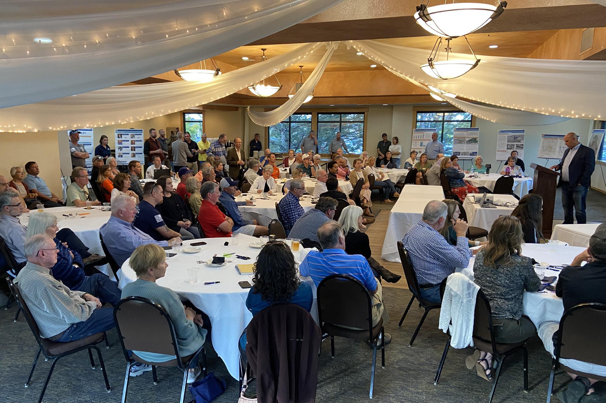
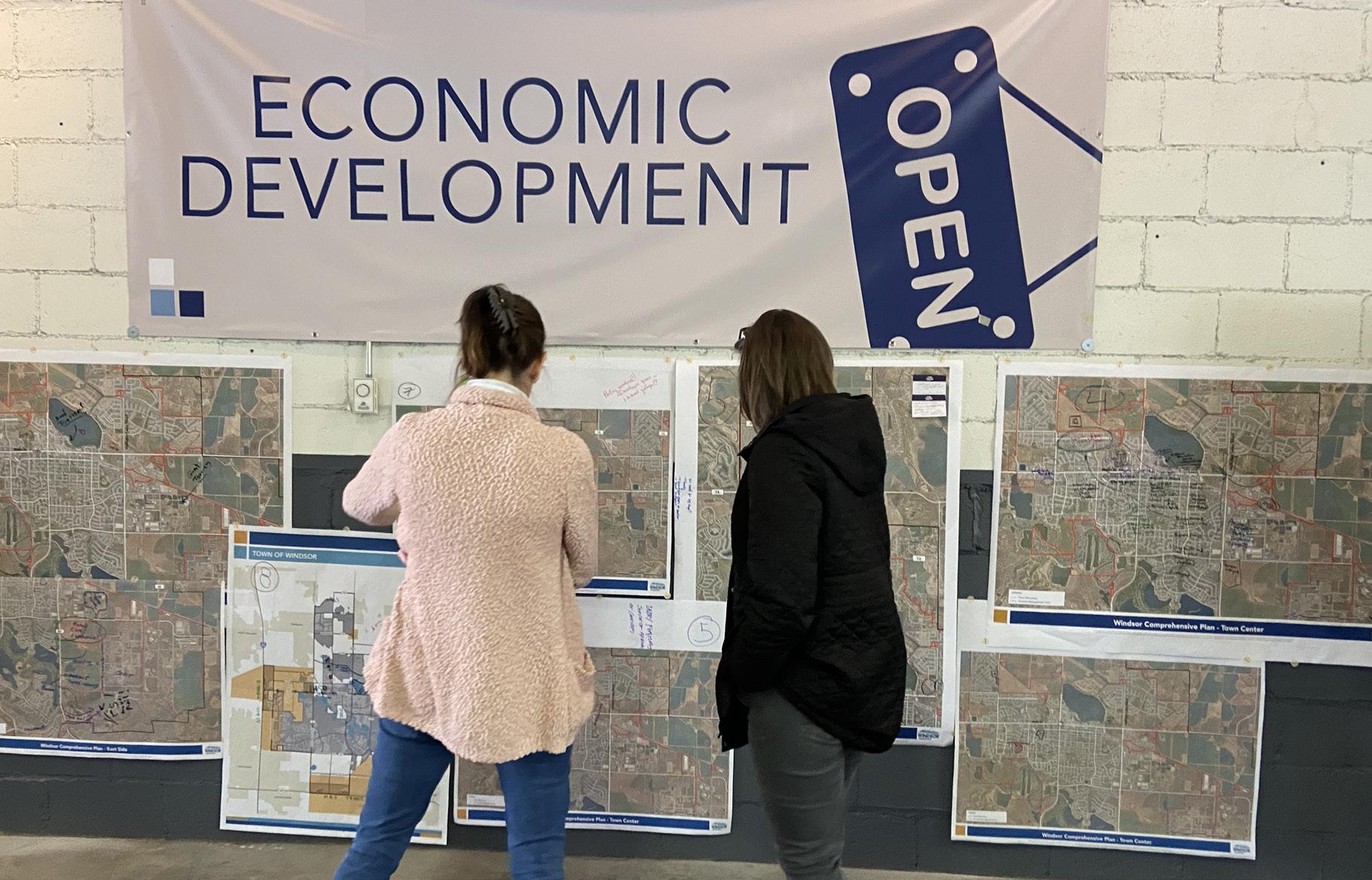
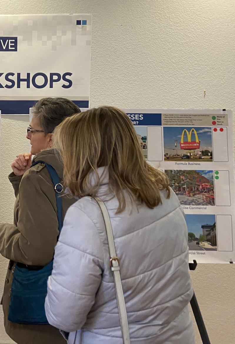
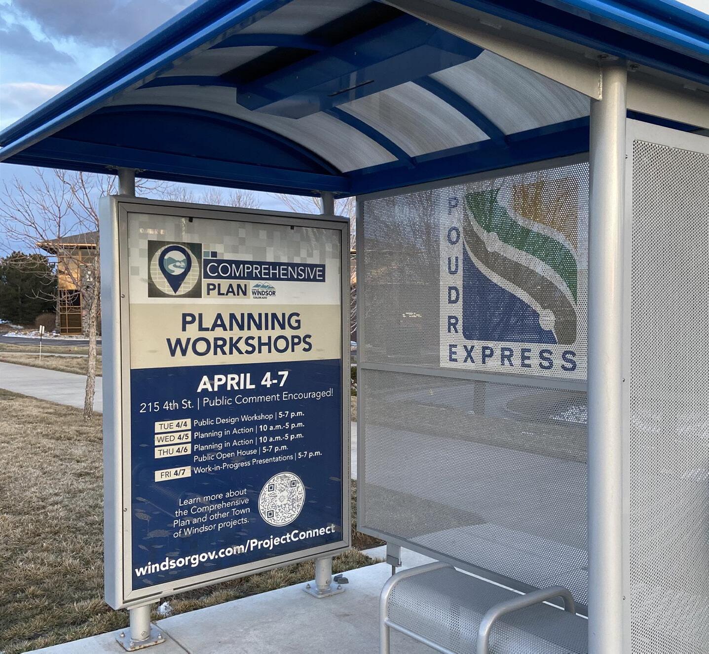
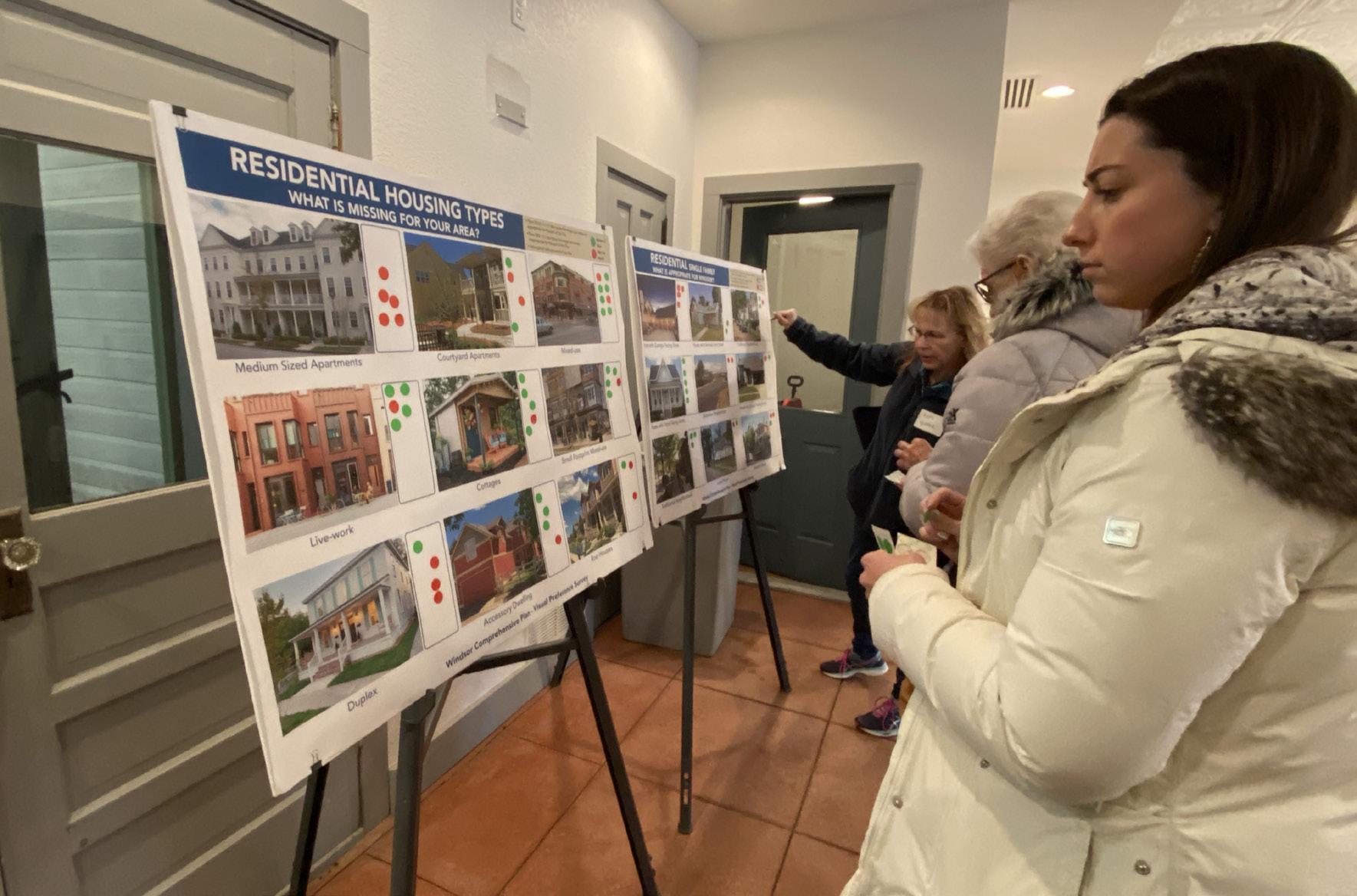
Community engagement is the cornerstone of the Comprehensive Plan. Collaboratively developing and updating the Plan not only helps to define the issues and shape a unifying vision, but it also establishes community consensus and fosters stewardship for the Plan.
The Plan update process kicked off in Fall 2022, with a Speaker Panel Event, community interviews, and the first online survey. This initial phase focused on understanding key issues, opportunities, and challenges that would influence policy direction in the Plan. In April 2023, a week-long public design workshop was held to discuss and visualize options for future community growth. The design workshop resulted in draft Focus Area Designs, draft Vision and Guiding Principles, and insight into updating the Future Land Use Map and categories. Moving into Summer 2023, a second survey asked the community to review the draft
Vision and Guiding Principles. Direct involvement with the Town Board and Planning Commission was also an essential element of this planning process in addition to input from a Public Advisory Committee made up of community members and a Technical Advisory Committee made up of Town Staff. At major milestones of Plan development, Town Board and Planning Commission provided input and direction.
A full Engagement Summary of all phases of public engagement is included in Appendix C.
More local parks and open space, trees and landscaping, and water efficiencies. “
These are some of the big ideas community members shared during the planning process and helped shape the vision, guiding principles, goals and policies in this plan.
More trails and connectivity to neighborhoods.
Commercial big box needed for food and home stores.
Facilitate consensus for downtown opportunities.
More entertainment and dining options.
More affordable housing for working professionals who support our community.
Ensure infrastructure (water, sewer, parking, roads, etc.) is in place to accommodate growth.
Open space conservation along river corridor and lakes. Preserve Windsor Lake and increase scenic buffers.
Preserve town character and beauty, including the Boardwalk Park and Lake area and downtown historic buildings.
What type of industries do we want to attract?
How do we use incentives to increase water efficiency?
How can we create a connected community?
How can we connect educational centers to industry?
How can we prioritize the creation and preservation of open space?
How can we preserve the unique community character of Windsor?
How do we balance parking needs with pedestrian areas?
How do we utilize design standards to create unique communities?
How can town leadership engage with the community?
How can we reduce traffic?
How can we support tourism and hospitality growth in Windsor?
Where can we expand trail networks?
How do we make Windsor more livable for teachers, police officers, etc.?
“
These questions posed by community members helped inform the opportunities the goals and policies— that will guide the future of Windsor.
• Existing Conditions
• Jurisdiction & Planning Area
• Land Use & Zoning Context
• Plans & Studies
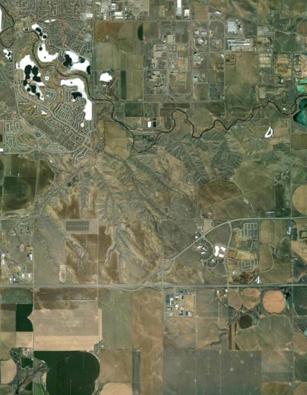
The Town of Windsor, Colorado was founded as a small 19th Century agricultural and railroad town and has evolved into one of the most desirable communities in Colorado.
Its desirability is reflected in the steady population growth over the last 30 years, with significant growth occurring between 2015 and 2022. As of 2022, Windsor’s population was 42,840 people. The previous 2016 Comprehensive Plan projected the Town to have a total population of 25,693 by 2020, which assumed the continuation of the historic growth rate between 1-3%. Windsor grew much faster, at a growth rate more than triple that projected under the 2016 Plan, averaging a 7% annual growth rate. Windsor’s rapid growth has transformed the Town into a largely suburban community, anchored by the historic downtown. Current population projections for 2041 range from 61,206, reflecting low growth, up to 89,389, reflecting high growth. The low-end projection, 61,206, is based on historic trends before the record high rate of building permits for the past five years. The high-end projection is derived from the Colorado State Demographer’s Office.
42,840
Demographics: Windsor has a large population of families and older residents, and the residents are generally highly educated. The Town’s median household income has been about 56% higher than the regional average for the last decade, which also translates into higher-priced housing and higher home ownership rates.
Housing: Windsor is one of the newer housing markets in the region, with over 60% of homes built after 2000. The Town also has a larger share of single-family housing units than its neighbors but more multifamily units than the smaller towns in the region. The 2016 Comprehensive Plan stressed the need for more diverse housing. Progress has been
made since the adoption of that plan, although more work is still needed. As Windsor grows and demand for housing increases, market demand will drive prices higher. Homeownership may become less attainable, and more types of housing will be needed to fill in housing gaps. Development of more multifamily, attached single-family, and condos will help mitigate the impacts of high housing costs by offering transitional housing options between renting and homeownership.
Population Trends by Jurisdiction, Source: Town of Windsor, Colorado State Demographers Office
Single-Family Detached (83%)
Single-Family Attached (5%)
Multifamily (12%)
Windsor’s Housing Units by Type,
Source: US Census, 2022 American Community Survey 5-Year Estimate
Land Use: Land use in Windsor is primarily residential and industrial, with room for growth in both areas. Of the Town’s developed land, residential land uses make up 61.5%, industrial land uses make up 12%, and commercial land uses make up 7.8%. Of undeveloped land, residential land uses make up 54.8%, industrial land uses make up 15.4%, and commercial land uses make up 12.3%. As Windsor considers its future growth patterns and land use designations, this Plan supports a balance of housing, retail, employment, and recreation options.
$121,754
Source: US Census, 2022 ACS 5-Year Estimates
Economic Development: Over a third of the Town’s jobs are in manufacturing, and according to the U.S. Census, a high percentage of people who work in Windsor live outside of Windsor. Most residents commute outside of Windsor for work. Significantly, 18% of the population works from home, which might help local businesses and services during the workday.
15% UNDEVELOPED INDUSTRIAL LAND of undeveloped land in Windsor is industrial.
54% UNDEVELOPED RESIDENTIAL LAND
Commuting patterns in and out of Windsor (2021), Source: LEHD, U.S. Census of undeveloped land in Windsor is residential.
Undeveloped Land in Windsor, Source: Town of Windsor
Transportation: Transportation in Windsor is closely tied to its economic growth and land use decisions. Windsor residents commute further than surrounding communities for work, and most drive alone. White the Town has an extensive trail system, Windsor is still largely car-dependent. There is a dedicated commuter bus line between Fort Collins and Greeley with stops in Windsor, as well as a connection to a Loveland bus route.
Water: Windsor has maintained a proactive stance toward water planning by securing additional water sources for future growth through the Northern Integrated Supply Project (NISP), implementing water efficient practices, and incentivizing the community to monitor their own water use. Windsor is also a regional leader in the use and requirement of non-potable irrigation systems in new developments. As growth on the Front Range challenges water resources, Windsor has demonstrated its ability to plan ahead and adapt to new conditions through partnerships and community-driven programs aimed at increasing the use of low-water and native plants.
THE TOWN HAS TAKEN STEPS TO MAXIMIZE WATER EFFICIENCY
Average Vehicle Miles Traveled per Household Comparison, Source: Housing and Transportation Affordability Index
Bike, Walk, Other (1 .3%)
Public Transport ( .1%)
Carpool (5 .3%)
Mode of Transportation to Work (Windsor), Source: U.S. Census, ACS K200801: Means of Transportation to Work: 2022: ACS 5-year Estimates
USING PROVEN PRACTICES AND TECHNOLOGIES, INCLUDING THE FOLLOWING:
• Installation of water-efficient appliances and irrigation systems at town facilities
• Lawn watering restrictions (no watering from 10 am-6 pm daily)
• Use of irrigation system rain sensors and ET based scheduling
• Detection of water leaks and repair through the Town’s water efficiency audits
• Establishment of a xeriscape garden to assist residents to understand and implement water saving landscapes and related technologies
Infrastructure: Windsor has a robust infrastructure system consisting of water, sewer, stormwater, and roads, all supported by either general, capital improvement, or enterprise funds. Spatially, the Town’s infrastructure is spread out, resulting in higher infrastructure service and maintenance costs. Land use decisions will play an important part in future infrastructure challenges or solutions as future development requires more connections to public services. Providing existing infrastructure can support development, concentrating development in appropriate areas could reduce overall construction and maintenance costs and increase efficiency and long-term sustainability of the system as a whole.
Additional context and trends can be found in Appendix D: Existing Conditions Report.
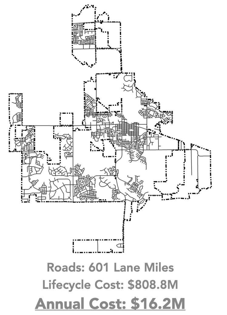
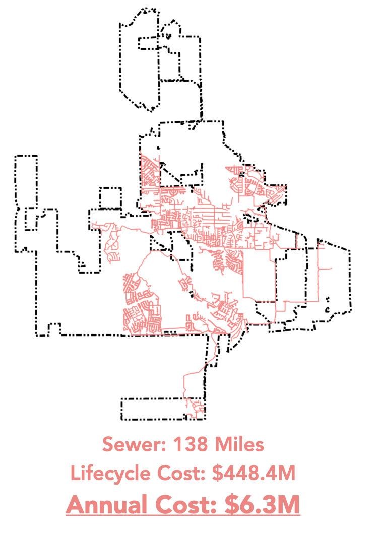
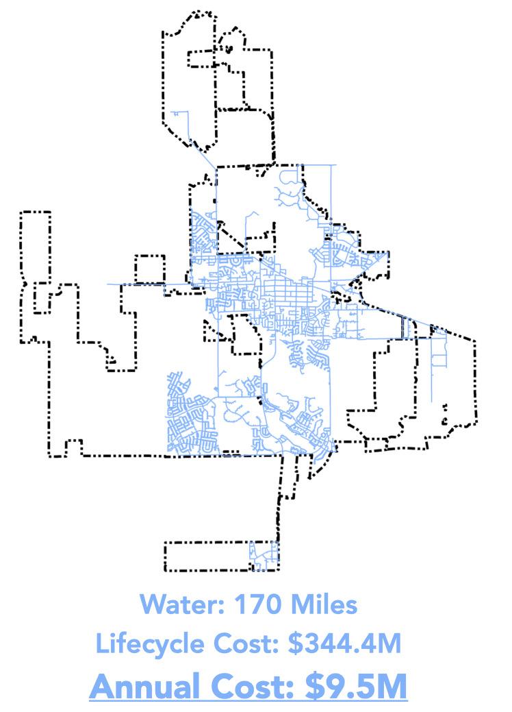
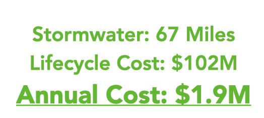
Cost of Windsor’s Infrastructure Systems, Source: Town of Windsor
The Town of Windsor is located in the Northern Colorado Front Range Region and Town boundaries extend across both Larimer and Weld counties. Surrounding communities include Timnath and Severance to the north, Fort Collins to the northwest, Loveland and Johnstown to the southwest, and Greeley to the southeast. Located on the I-25 corridor, Windsor sits approximately 56 miles north of Denver.
This Comprehensive Plan applies to areas within the municipal boundaries of Windsor as well as the unincorporated areas that fall within the Town’s Growth Management Area (GMA). The land within the GMA is anticipated to be served with municipal services and infrastructure to support future development. Development in close proximity to the Town core and existing infrastructure is a priority, but areas in the GMA will likely experience development pressure and are anticipated to be annexed into the Town in the future.
The Colorado Revised Statutes § 3112-105 require every municipality to have a plan in place for areas within a 3-mile distance of its municipal boundary prior to any annexation. The 3-mile planning area does not include land incorporated by other municipalities or claimed through a formal intergovernmental agreement. As much of the Town’s GMA is abutting the GMA and/ or corporate limits of neighboring communities, Windsor does not intend to extend the GMA boundaries beyond the boundary that exists today.

The Town of Windsor has entered into several land use specific Intergovernmental Agreements (IGAs) with neighboring municipalities to jointly plan for future development. These include components such as a determination of future land uses, design standards, and in certain instances, revenue sharing. In some cases, the IGAs resulted in Cooperative Planning Areas where both jurisdictions agree to design and performance standards for development.

Anchored by a historic downtown, the Town includes a mix of new and old residential districts, emerging commercial centers, and an evolving industrial sector. Windsor includes a diverse range of land uses that accommodate residential, commercial, and industrial users.
The Town’s residential neighborhoods are comprised of historic homes near downtown as well as newer subdivisions, many of which surround golf courses and large open spaces and have been built in the last 20 years. The Town’s commercial and retail areas are anchored on Main Street (SH 392) and downtown Windsor, while I-25 and emerging east-west corridors like Harmony Road, Crossroads Boulevard, and Highway 34 play an increasingly important role in the area’s growth. Additionally, the Great Western Industrial Park includes large-scale sites and heavy manufacturing uses, which defines the eastern parts of Windsor and carries implications for land use and economic planning across the community.
As part of the comprehensive planning process, a character analysis identified ten different character types in Windsor. The classifications are based on spatial attributes, street pattern, zoning, and land use. Spatial attributes include building height and sizes of lots, as well as the relationship between the buildings and street. The street pattern greatly influences connectivity and major modes of transportation.
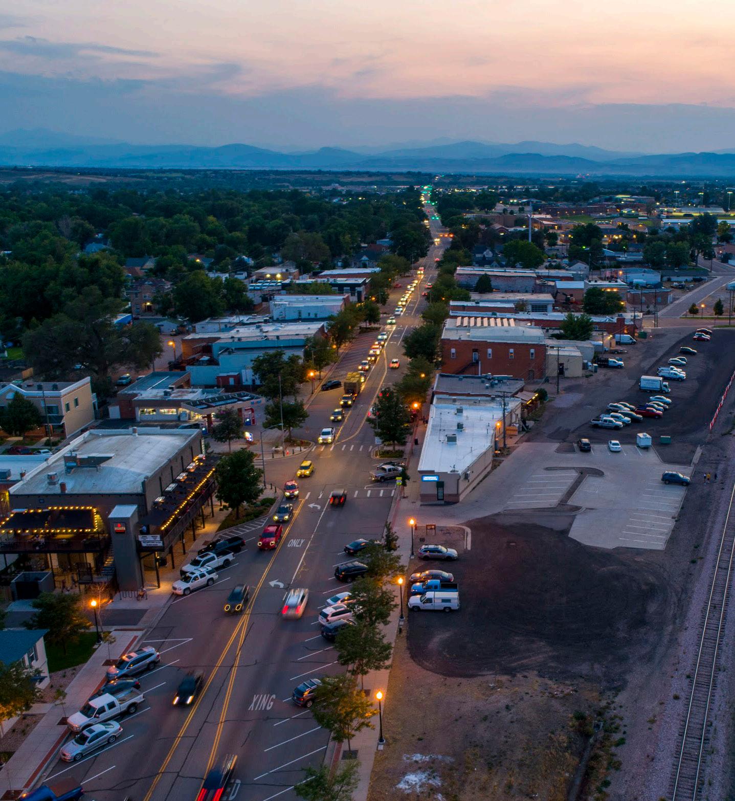
Downtown Core: The downtown core of Windsor is near Windsor Lake. The Great Western Railroad runs through downtown diagonally, creating a triangular space with 7th Street and Main Street. The downtown core has the highest concentration of restaurants, shops, and various services in town.
Traditional Neighborhood: Traditional neighborhoods surround downtown and were mostly developed before 1970. These neighborhoods have smaller blocks and wellconnected street networks. The land use is mostly single-family housing with amenities like schools, and religious institutions that are integrated within residential areas. This neighborhood also has access to services and jobs in the downtown core only a short walk away.
Cluster Development: This character area encompasses neighborhoods that arrange homes and developments in clusters to conserve open space, parks, or sensitive environmental areas.
These neighborhoods typically have more public spaces.
Suburban: The suburban character type is the most common development pattern in the Town of Windsor. This type of development mostly consists of detached single-family homes, often as part of a planned subdivision, and garages often face the street.
Agriculture and Emerging Growth: This character type refers to lands that are currently vacant or used for agricultural purposes. Current zoning allows for development and some level of future growth or change in use can be expected in these areas.
Institutional: The institutional character type covers civic and educational spaces such as the High School, police buildings, fire stations, Town Hall, and Community Recreation Center.
Commercial Corridor: Commercial corridor areas refer to retail and office developments that prioritize vehicular access and are usually located around major roads and corridors. The Town’s land use code and commercial corridor plans strive to de-emphasize parking and encourage buildings to front the street. The areas along Highway 392 outside of downtown currently have the highest concentration of commercial corridor developments.
Heavy Industrial: Most of the heavy Industrial areas are in the eastern side of the Town. The buildings and structures in this character area support higher intensity of land use, often with greater volume of truck traffic, noise and other factors that are not compatible with residential development. These areas also generally have convenient access to major roadways and railroads.
Light Industrial: Light industrial uses produce smaller consumer goods and include warehousing, research, and development. The land use intensity
As the long-term guide to future development in the Town, the Comprehensive Plan provides the policy direction that should guide any future zoning requirements or development standards. Generally, the adoption of the Comprehensive Plan should be followed by an initiative to update the Town’s development codes, which includes zoning regulations, subdivision regulations, and others. Changes to the Town’s zoning regulations may include the refinement of existing regulations to address height, bulk, and intensity standards, as well as permitted uses.
The previous 2016 Comprehensive Plan document and Municipal Code were generally in alignment, at the time of adoption of this updated Plan. While there should be an understanding of what zoning districts could apply to each Future Land Use category, the Future Land Use Map in this Comprehensive Plan is not granular as is the regulatory zoning map. Instead, the Future Land Use Map provides a general guide of character and land use types that encompass neighborhoods or corridor areas.
More information about Future Land Use designations and categories is in Chapter 4: Future Land Use Plan.
is less than heavy industry. Light industrial businesses tend to cluster together to form bigger light industrial zones and are usually separated from residential areas.
Natural Edge and Open Space: The natural edge and open space are lands reserved for parks, outdoor recreational, and ecological services. The riparian buffer along the Poudre River plays an important role in protecting biodiversity and water quality.
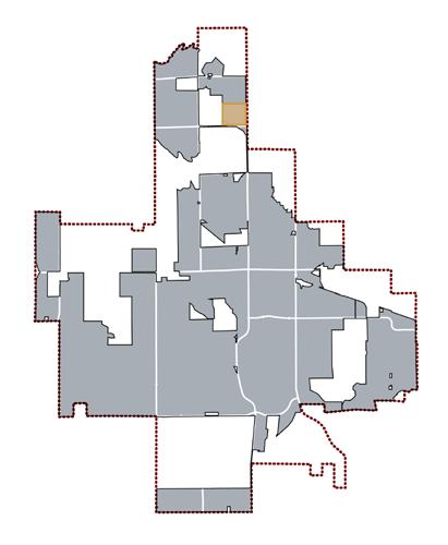
The zoning regulations are located within the Town of Windsor Municipal Code, Chapter 16, and an example of the Zoning Map is included on the next page. The Zoning Code includes requirements for 16 zoning districts, including:
• Estate Residential (ER)
• Single-Family Detached (SF-1)
• Single-Family Attached (SF-2)
• Multifamily (MF)
• Residential Mixed Use (RMU-1 and RMU-2)
• Mobile Home (MH)
• Neighborhood Commercial (NC)
• Central Business (CB)
• General Commercial (GC)
• Limited Industrial (LI)
• Heavy Industrial (HI)
• Recreation and Open Lands (ROL)
• Agriculture Holding (AH)
• Planned Unit Development (PUD)
• Public Parking District (PP) (subarea of the CB zone district)

For the most up-todate zoning map, visit the Town’s webpage here.
The Comprehensive Plan builds on several existing plans and studies, which have influenced, and will continue to influence, Windsor’s growth and development. The Comprehensive Plan incorporates past policy direction where it continues to be reflective of the community’s vision. Many of these supporting documents provide further guidance on specific topics such as transportation planning, parks and open space, and parking. The most relevant plans and studies are summarized below and referenced throughout the Plan.
Existing plans & studies help inform the Comprehensive Plan.
Potable Water Master Plan (2009): The objective of the Potable Water Master Plan is to provide the Town’s decision makers with the information needed to make sound decisions associated with its water portfolio.
Demographics and Housing Opportunities Study (2015): This study identifies evolving trends and changes to existing development policies, to respond to emerging housing needs. The study provides general and policy recommendations focusing on diversity of housing, aligning jobs with the resident workforce, and identifying strategic areas for denser residential development.
Transportation Master Plan (2020): As Windsor’s first Transportation Master Plan, it serves as a long-term vision and guide for multimodal transportation. It includes short-term action items and integrates the 2017 Roadway Improvement Plan to plan for a connected, efficient, and comfortable network for bicycling, walking, taking transit, and driving.
Windsor Public Art Master Plan (2020): The Public Art Master Plan provides guidance for the Town of Windsor, Windsor Art Commission, artists, community stakeholders, and others interested in helping advance the future of public art in Windsor. Since its adoption in 2020, the Town Board adopted a public arts ordinance and established the Windsor Arts Commission.
Parks, Recreation, and Culture Strategic Plan (2020): This plan serves as a roadmap for the Town, Parks, Recreation & Culture Advisory Board, and the Town Board. It strengthens and strategically expands existing programs, facilities, and amenities.
Open Space and Trails Strategic Plan (2022): The Open Space and Trails Strategic Plan provides a five- to ten-year framework to define areas for open space preservation and trail development within Windsor’s GMA. The Plan serves as a strategy and policy document for open space acquisition, long-term stewardship, capital project planning, and funding efforts.
Energy Action Plan (2023): The Town’s first ever Energy Action Plan is intended to explore ways to help the community save energy and money while leveraging renewable energy programs. The action plan establishes an overall vision, goal, and seven focused strategies to achieve that direction.
Historic Preservation Master Plan (2023): The Preservation Plan serves as a guiding document for the Historic Preservation Commission and outlines Windsor’s vision for the sustainable preservation of historic resources. It sets forth goals, policies, and an action plan for implementation. It serves as an informational resource for property owners and members of the general public to learn about preservation in Windsor.
Subarea and Corridor Plans: Windsor has several subarea and corridor plans that include more detailed land use, transportation, economic goals and recommendations, as well as design standards. The Town of Windsor also has developed Intergovernmental Agreements (IGAs) with adjacent communities, including but not limited to Fort Collins, Severance, Timnath, Loveland, and Greeley; as well as the counties of Weld and Larimer.
• 7th Street Multimodal/Walnut Street Bikeway Study
• O Street Corridor Study
• Downtown Windsor Parking Study
• Eastman Park Drive Corridor Plan
• Corridor Activity Center (CAC) Design Standards
• Downtown Corridor Plan
• I-25 Corridor Plan and Regional Design Standards
• Commercial Corridor Plan Design Criteria and Procedures
• East Side Industrial Subarea Plan
• Great Western Annexation Design Criteria and Development Standards
The Windsor community has come together to articulate a common vision that embraces our future and builds on the identity we share in our geographical location and outdoor environment. To realize our vision, we must act boldly, build on our strengths, and confront our challenges. The goals we envision and the actions we take today will define our Town’s future.
Visioning is a critical part of any long-range plan. It establishes a community-driven direction that acts as Windsor’s compass to define Windsor over the next 10 to 20 years and provides the central strategic approach to public decision-making. The Comprehensive Plan has a unifying Vision statement as well as 10 Guiding Principles that articulate more specific community values. Together, these statements guide the intent behind the goals, policies, and implementation strategies identified later in the Plan.
As a community, we envision a safe, sustainable, and thriving Town that prioritizes a high quality of life through thoughtful growth and development, fostering a sense of community, and responsible stewardship of its natural resources and open space.
1 Balanced and sustainable growth that contributes to Windsor’s sense of place and enables quality of life, amenities, and services.
3 A vibrant, diverse, and resilient economy that builds upon Windsor’s dynamic commercial, educational, and employment areas.
5 A safe, efficient, comfortable, and intuitive transportation system that serves all ages and abilities.
7 Ease water availability limitations through robust and proactive planning for water efficiency.
9 A thriving community with access to high-quality public facilities and local services.
2 Neighborhoods that focus on road and trail access and high quality of life for households of all sizes and incomes.
4 A small-town character and safe environment that makes Windsor a desirable place to live, work, and play.
6 Exceptional and memorable park, recreation, open space, and trail experiences accessible to everyone, that incorporate wild landscapes and a sense of discovery.
8 Stewardship of natural resources to help preserve a healthy and thriving environment for present and future generations.
10 A fiscally responsible community, which focuses on prioritizing local services, amenities, and high quality of life.
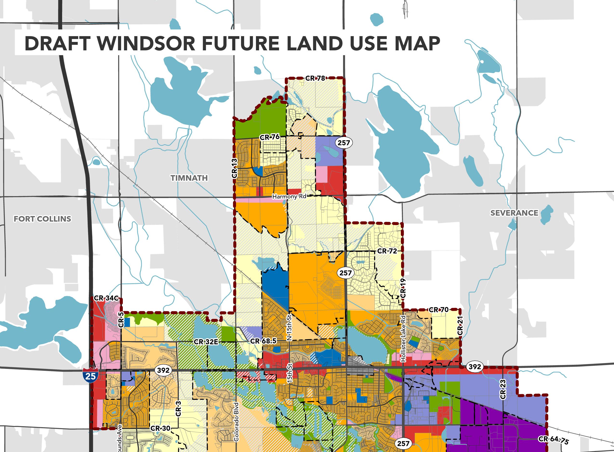
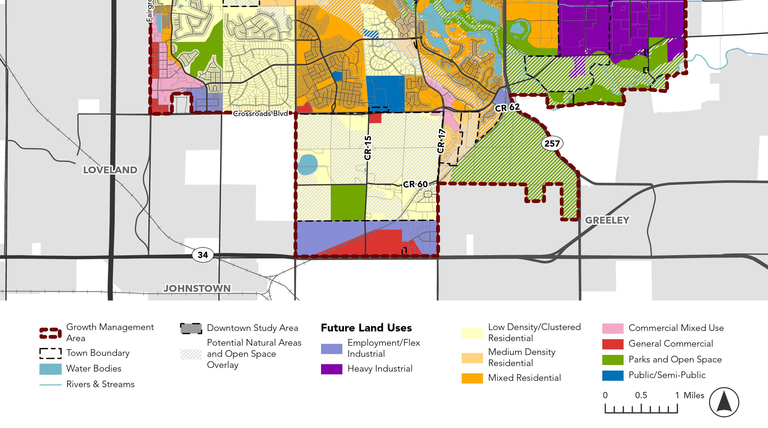
The Future Land Use Plan is designed to shape future development and growth in Windsor for decades to come.
The map and associated land use categories provide a guide for Town officials, developers, and residents and indicates what type of development will appropriately reflect the community’s long-range goals and vision for Windsor.
Land use densities shown in this Comprehensive Plan land use map and descriptions are far greater than what is assumed in Town sewer master plans, Water Master Plan and Transportation Master Plan. Therefore the Comprehensive Plan must address how the deficits in supporting infrastructure are to be addressed. Sewer interceptor infrastructure will likely be deficient if the densities shown on the land use map are evenly distributed over emerging growth areas.
The Future Land Use categories provide insight into preferred densities, uses, and characteristics that would be most suitable for each Future Land Use category. The Future Land Use categories were established based on conversations and engagement activities with community members, Town staff, and elected officials conducted throughout the planning process. The categories have been modified from the 2016 Future Land
Future land use category
Key elements within the category
General guidelines for the allowable uses within the category
Use categories to reflect the community’s vision and goals for the future.
This section illustrates how each land use would align with existing zoning in Windsor. These categories provide the framework for any future zoning updates. The following diagram illustrates how each of the land use category pages are structured.
KEY CHARACTERISTICS SUGGESTED DENSITY RANGE
• Single-family homes, including both planned subdivisions and large-lot family homes developed over time.
• Contributes to the rural character of Windsor and helps transition and buffer from other towns, outlying rural areas, or sensitive natural features such as the Poudre River and the bluffs adjacent to Raindance.
• Clustered development protects environmentally sensitive areas.
RESIDENTIAL
• Primary: Detached singlefamily homes, large-lot homes, small-lot clustered neighborhoods
• Secondary: Accessory dwelling uses
Up to 1.25 DU/Acre
ALIGNMENT WITH CURRENT ZONING
Estate Residential (ER)
Suggested range of density to achieve the desired form for the category
Identifies which current zoning categories align with the land use category
RECREATION
• Parks, open space, agriculture and equestrian uses
• Single-family homes, including both planned subdivisions and large-lot family homes developed over time.
• Contributes to the rural character of Windsor and helps transition and buffer from other towns, outlying rural areas, or sensitive natural features such as the Poudre River and the bluffs adjacent to Raindance.
• Clustered development protects environmentally sensitive areas.
• Primary: Detached singlefamily homes, large-lot homes, small-lot clustered neighborhoods
• Secondary: Accessory dwelling uses
Up to 1.25 DU/Acre Estate Residential (ER)
ALIGNMENT WITH CURRENT ZONING
• Parks, open space, agriculture and equestrian uses RECREATION
• Neighborhoods with primarily single-family homes, and a smaller mix of duplexes, townhomes, and multifamily
• There are bike and pedestrian connections to nearby parks, schools, and open space.
• Generally considered suburban neighborhoods.
Up to 4 DU/Acre
ALIGNMENT WITH CURRENT ZONING
Single family (SF-1)
Single-family attached (SF-2)
Mobile home (MH)
Multifamily residential (MF)
Residential mixed use one (RMU-1)
Residential mixed use two (RMU-2)
• Primary: Single-family detached homes and duplexes
• Secondary: Townhomes, small multifamily apartments/ condos, accessory dwelling units
CIVIC RECREATION
• Schools, places of assembly, libraries, police and fire stations, and government offices
• Parks and open space
• Promotes compact, pedestrian-oriented neighborhoods with a variety of housing types and densities, small-scale commercial activity centers, and other public amenities.
• Accommodates a range of housing types, including single-family detached, attached, and multifamily.
• Promotes development that caters to a variety of family sizes and incomes and provides an opportunity for residents to age-in-place.
6 - 12 DU/Acre
Residential mixed use one (RMU-1)
Residential mixed use two (RMU-2)
Multifamily residential (MF)
• Primary: Single-family homes, multifamily apartments/ condos, townhomes, duplex, and triplex.
• Secondary: Senior housing and assisted living facilities
• Small-scale retail and restaurants, Small-scale office
• Schools, places of assembly, libraries, police and fire stations, and government offices
• Parks and open Space
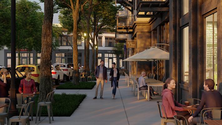
• Traditional and historic downtown area that honors Windsor’s history and provides a smalltown feel.
• Includes a mix of commercial, office, and complementary residential uses to create a vibrant town center that concentrates a range of activities.
• Residential uses on upper levels of commercial buildings are encouraged.
• Primary: Retail, service, restaurants, cultural or entertainment uses
• Secondary: Upperstory residential with commercial
4-12 DU/Acre
Central business (CB)
Permanent parking (PP)
• Offices
• Multifamily on upper levels of commercial buildings
• Parks and open space
• Schools, places of assembly, libraries, police and fire stations, and government offices
• Walkable commercial areas that integrate residential uses, with commercial uses on ground-floors and along primary corridors.
• Multifamily residential uses can be integrated into the site design by including on upper stories of a mixed-use building.
• An interconnected grid of streets and pedestrian connections is emphasized.
• As traditional shopping centers age, redevelopment should integrate residential uses to activate and revitalize the center the site.
• Parking should be located behind buildings, below grade or in structures.
• Auto-oriented uses should be limited.
• Primary: Local commercial and service uses, such as restaurants, personal services, small shopping centers, medical facilities, and multi-tenant centers
• Secondary: Hotels
Up to 30 DU/Acre Neighborhood commercial (NC) General commercial (GC)
• Professional offices
• Multifamily on upper levels of commercial buildings
• Places of assembly, libraries, police and fire stations, and government offices
• Shopping centers, lifestyle centers, or commercial corridors that are not intended to integrate residential uses.
• These areas are appropriate for auto-oriented uses, stand-alone uses with vehicle drivethroughs, and larger scale shopping.
• Generally located along Windsor’s primary arterial corridors and highways, with excellent access and visibility.
• Primary: Retail stores, eating establishments, supermarkets, multiplex movie theaters, medical facilities
• Secondary: Hotels, personal services, small shopping centers, and multi-tenant centers
General commercial (GC) N/A
• Professional offices
• Places of assembly, libraries, police and fire stations, and government offices
• Provides flexible employment uses, light industrial, and supporting commercial businesses.
• Activities within this category tend to occur inside structures, with outdoor areas allowing well-screened and limited storage or distribution.
• Uses should be well-screened and buffered from adjacent non-business type uses.
• Primary: Professional office, research and development labs, business and office parks
• Secondary: Light manufacturing, processing, production, warehousing, distribution of goods N/A Limited industrial (LI)
• Supporting commercial uses, hotels
• Given the freight traffic, visual, noise, and environmental impacts generated by heavy industrial uses, these areas should mitigate impacts if and when those uses are adjacent to incompatible uses.
• Residential land uses adjacent to heavy industrial uses should be heavily buffered and screened from view.
• High-intensity facilities that involve the processing of chemicals or plastics, refineries, and industrial machinery
Heavy industrial (HI) N/A
• Generally integrated within and adjacent to residential and commercial land uses to serve the Windsor community and nearby areas.
• Schools, libraries, police and fire stations, and government offices
• Intended as accessible public amenities for residents and the broader community.
• Primary uses: Active and passive recreation, sports facilities and fields, golf courses, gathering spaces associated with athletics, greenways and trails, community gardens, undeveloped natural areas, conservation easements
• Secondary uses: Temporary mineral extraction sites, such as gravel mining
N/A Recreation and open lands (ROL)
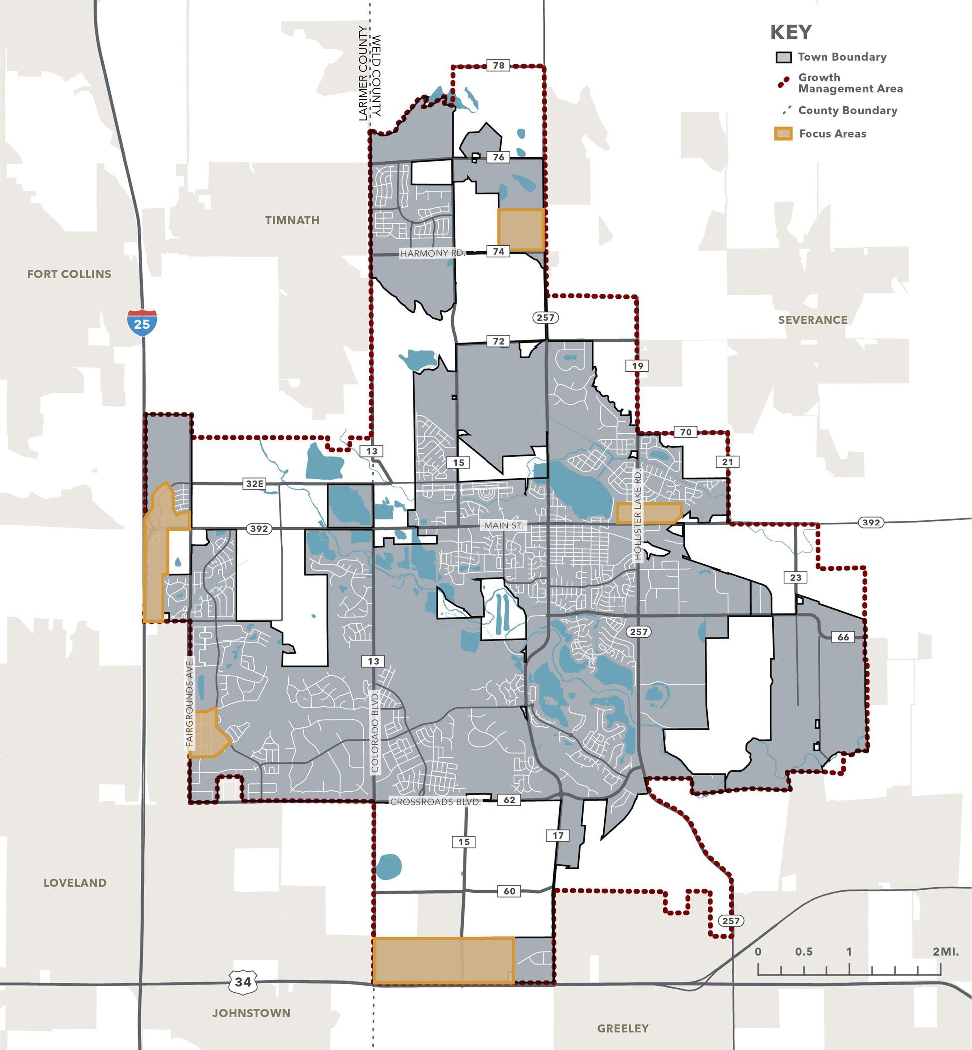
Five Focus Areas were identified through the planning process as areas for future growth. By taking a close look at the site-specific opportunities, constraints, and community preferences, conceptual site designs and graphic renderings were created to show potential development concepts. These conceptual designs
and graphics help to illustrate possible character, uses, and experiences within each Focus Area, and do not reflect all current zoning, building, or design requirements. The conceptual designs are generally consistent with the policy direction and the Future Land Use Plan in this Comprehensive Plan.
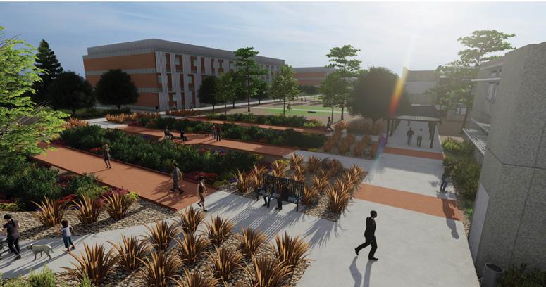
1 . CORRIDOR ACTIVITY CENTER
2 . DOWNTOWN WINDSOR EXTENSION AND INFILL
3 . HIGHWAY 34 AREA
4 . HARMONY AND HIGHWAY 257 AREA
5 . FAIRGROUNDS AVENUE AREA
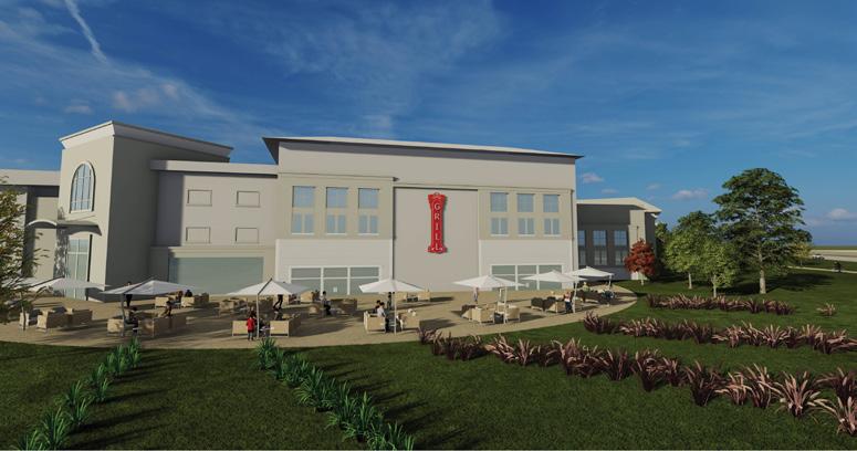
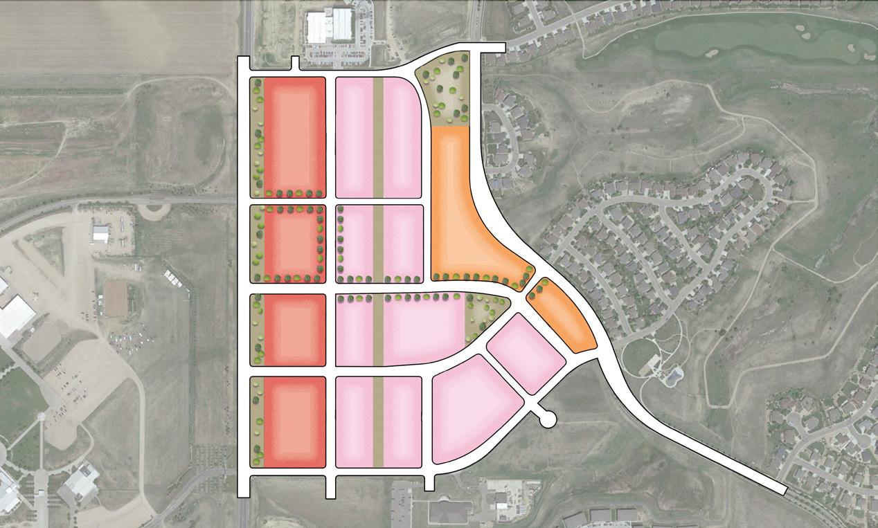
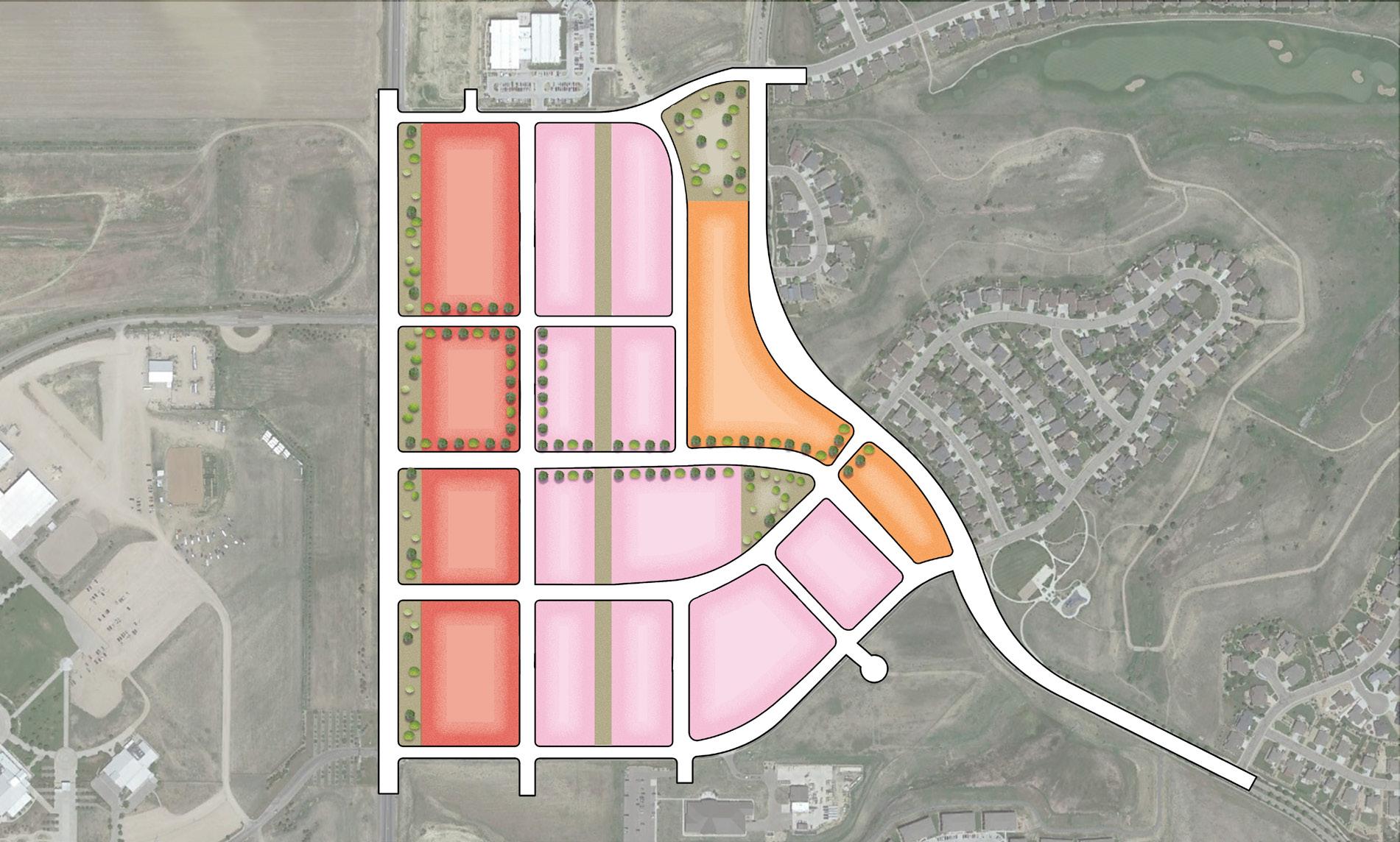
CORRIDOR ACTIVITY CENTER
FAIRGROUNDS AVE .
HIGHWAY 34
HARMONY AND HIGHWAY 257
DOWNTOWN EXTENSION
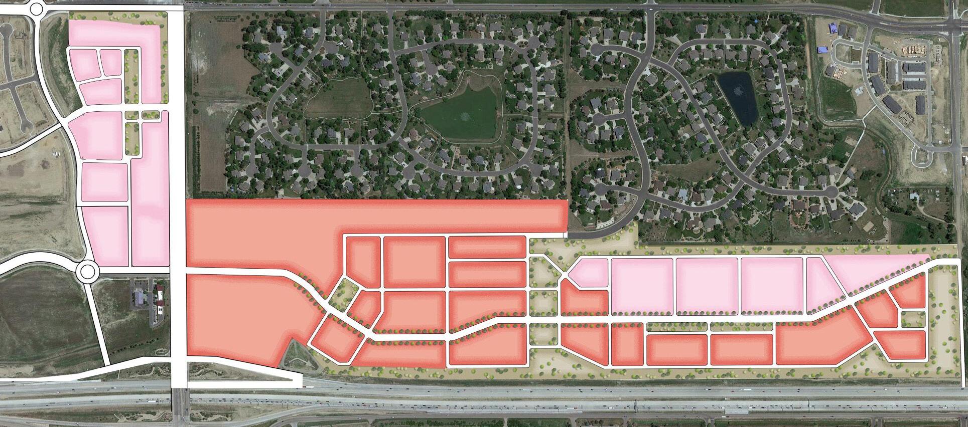
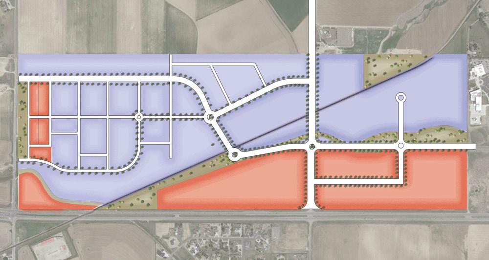
Corridor Activity Center
Location: This covers an area governed by an Intergovernmental Agreement (IGA) between Windsor and Fort Collins along I-25 and Hwy 392.
Characteristics and Constraints:
Future Land Use Mix:
The IGA establishes design standards to unify the appearance. Currently, the site’s zoning is a mix of General Commercial, Limited Industrial, and Residential Mixed Use.
60% General Commercial
25% Commercial Mixed Use
15% Parks and Open Space
Defining Features of Design:
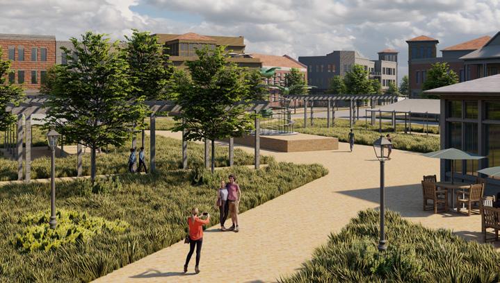
A central plaza functions as a community gathering space for events such as farmers markets, presentations, and celebrations. Large sidewalks lend themselves as optimal spaces for outdoor dining, shop signage, and increased walkability.
On-street parallel parking offers supplemental parking options to the rear parking lots located behind the mixed-use buildings. Having a variety of activated plaza spaces helps to identify the character of the area, which attracts visitors and become wayfinding points throughout the area.
The corridor contains strategic pockets of green space utilizing native plants and offers plenty of shaded seating. The corridor will be multimodal with a focus on comfortable navigation for pedestrians and bicyclists.

Corridor Activity Center, Future Land Use Plan
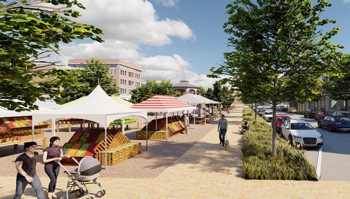
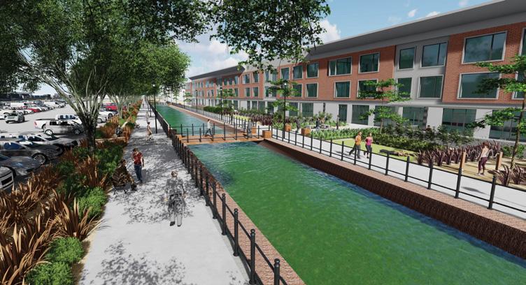
Corridor Activity Center, Conceptual Illustration
Note: The plan and illustrations are representative of the type of development allowed in this area. Actual development will vary. Focus
Corridor Activity Center, Conceptual Illustration
Downtown Windsor Extension and Infill
Location: This site is located east of downtown, along Main Street and straddling Hollister Lake Rd.
Characteristics and Constraints:
The main street of Windsor in downtown has the highest concentration of historical and cultural structures. The continuous building walls, street trees, wider sidewalks, and on-street parking create a friendly and walkable environment. The small-town character of Windsor is best represented in these downtown main street blocks.
The current zoning on the site is Limited Industrial, General Commercial, and Residential Mixed UseOne. A utility easement bisects the western site diagonally.
Future Land Use Mix:
50% Mixed Residential
40% Commercial Mixed Use
10% Parks and Open Space
Defining Features of Design:
The proximity to downtown makes this a prime location for additional retail and mixed use. The interconnected street network is designed for a continuous flow of vehicles and minimal congestion. To accommodate the diagonal utility easement, green areas and parking lots are located along this utility alignment and buildings are set back 50 feet. Sufficient space is provided for parking in the center of blocks keeping the streets activated and walkable. This walkable character is integrated throughout the site, but especially along Main Street/Highway 392, to visually connect the site to downtown. The mixed use nature of the site is intended to create interest and diversity when exploring the area.
Vacant sites are limited in the downtown area, but certain sites could be imagined for other uses in future. One example is the southeast corner of the intersection of 4th Street and County Road 68. This street corner could accommodate a multi-story, mixed-use building. The structure could accommodate uses residents desire such as a restaurant, rooftop dining, small-scale retail, residential units, or outdoor seating areas.

Main Street/Highway 392 is an important gateway to the community. The character of Main Street changes drastically east of the railroad crossing near 3rd Street. The sidewalk terminates abruptly, and buildings are set back further from the street.
The waterfront site that borders the train tracks, 2nd Street and Main Street has the potential to host a gateway feature. During the weeklong design workshop conducted during the planning process, residents expressed preference for using iconic buildings as gateway features. An elegant hotel building with vertical building features is one possible use of the space. Signage could be installed to point motorists, pedestrians, and cyclists to main points of interests in downtown.


Disclaimer: The plan and illustrations are representative of the type of development allowed in this area. Actual development will vary.
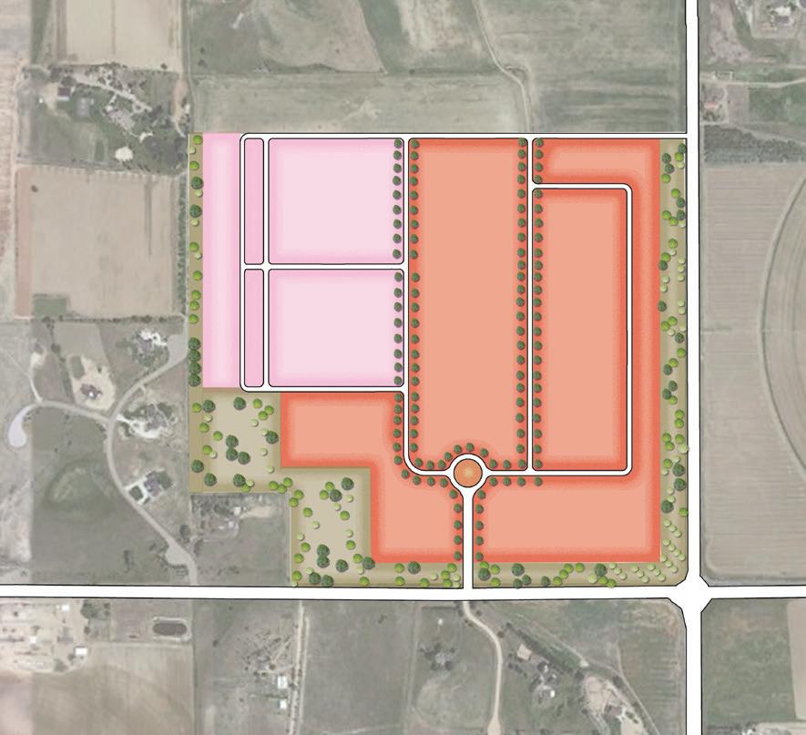
Highway 34 Area
Location: The site is Windsor’s southern gateway off Hwy 34 and Colorado Blvd.
Characteristics and Constraints:
Future Land Use Mix:
A railroad bisects the site, as well as irrigation canals and utility rights of way. The current zoning is Limited Industrial.
25% General Commercial
60% Employment/Flex Industrial
15% Parks and Open Space
Highway 34 Area, Future Land Use Plan

Defining Features of Design:
The design is intended to advocate for light industrial uses supplemented by retail and office uses. The opportunity for AIMS Community College to expand west can be intertwined with related professional offices, ultimately creating new relationships between the academic and professional communities. Retail, restaurants, and office space along US Hwy 34 and along Colorado Blvd provide visibility to passing car traffic.
Disclaimer: The plan and illustrations are representative of the type of development allowed in this area. Actual development will vary.
In the center of the site, large, light industrial office and warehouse buildings provide expanded employment opportunities. Increased investments along the existing irrigation canals could include multi-purpose trails and attractive business offices campuses.
Highway 34, Conceptual Illustration
Highway 34, Conceptual Illustration
Harmony and Highway 257 Area
Location: The site is Windsor’s northwest gateway along East Harmony and Hwy 257.
Characteristics and Constraints:
Future Land Use Mix:
Adjacent land uses are mostly residential. The current zoning for the site is General Commercial.
60% General Commercial
30% Mixed Residential
10% Parks and Open Space
Disclaimer: The plan and illustrations are representative of the type of development allowed in this area. Actual development will vary.
Harmony and Highway 257 Area, Future Land Use Plan
Defining Features of Design:

This northern gateway will prioritize lifestyle retail shopping and restaurants, with townhomes and apartments adjacent to existing single-family neighborhoods. Entry roads align with existing access to the south and northeastern.
With a focus on commercial development, the plan would provide opportunities for a variety of unique businesses, restaurants, and provide employment opportunities within Windsor town boundaries.
Harmony and Highway 257 Area, Conceptual Illustration
Harmony and Highway 257 Area, Conceptual Illustration Focus Area Location
Fairgrounds
Location: The site is southwest Windsor, located along Fairgrounds Avenue.
Characteristics and Constraints:
Future Land Use
Mix:
Adjacent to residential uses and Belmont Ridge Open Space to the east and N. Fairgrounds Ave. to the west. The current zoning is Limited Industrial.
30% General Commercial
40% Commercial Mixed Use
20% Mixed Residential
10% Parks and Open Space
Defining Features of Design:
The design is intended to support mixed residential and commercial mixed use. First floor commercial uses wrap around the perimeter of the site with opportunities for second-story residential uses. The site is intended to be a pedestrian-oriented development with primary vehicular access through gateways along Fairgrounds Avenue.
representative of the type of development allowed in this area. Actual development will


This page is intentionally left blank.
• Growth & Regional Collaboration
• Housing & Neighborhoods
• Economic Development
• Community Character & Design
• Transportation & Mobility
• Parks, Recreation, Open Space & Trails
• Water & Natural Resources Stewardship
• Community Facilities & Infrastructure
While the Vision and Guiding Principles establish the community-driven direction, the goals and policies provide the central strategic approach to public decision-making. Together, these statements guide the intent behind the goals, and policies that aim to shape the future of the places we live, work, play, and learn. Each element within the Plan contains Goals, actionoriented statements of the envisioned outcome, and supporting each Goal is a set of Policies, which describe more specific ways in which to make progress toward the Goal.
Implementation Actions are introduced in Chapter 6, Implementation, and further detailed in Appendix B, Implementation Action Matrix. Actions are the activities the Town will undertake to implement the Goals and Policies within the Plan. The Action Matrix defines the type and responsible department for undertaking each action. This Plan will be used annually as Town Board and each Town department sets annual workplans and strategic goals. The Action Plan is intended to be updated to reflect the Town’s most current policies, data, and accomplishments.
Historically, Windsor has seen modest population growth year after year. However, starting in about 2016, significant residential development meant Windsor saw a substantial increase in annual population growth rates. This mirrors booming growth across Northern Colorado, including Windsor’s neighboring municipalities.
Population projections for Windsor’s continued growth through 2040 vary depending on the source but range from a low growth estimate of about 60,000 up to over 85,800 people as a high growth estimate. These estimates do not reflect an ultimate buildout population. However, it does indicate that a well-managed growth and land use strategy set in place now could significantly influence how Windsor’s vacant areas develop over the next 20 years.
Even with recent growth, there is still opportunity for new development across the Town. Windsor currently has more than 8,000 acres of potentially developable land within its Growth Management Area – almost 30% of the total GMA. Developable land includes greenfield areas that are currently used for agriculture and sites that have seen conceptual ideas from property owners. Given the amount of developable land, the Town has an opportunity to both grow in size and population,
• Intergovernmental Agreements
while conserving resources and preserving rural areas. Through the planning process, the Windsor community highlights the desire for balanced and sustainable growth that contributes to Windsor’s character and enables quality of life amenities and services for everyone. This is embodied as a Comprehensive Plan Guiding Principle.
Constituents have consistently cited Windsor’s “small-town charm” while sharing concerns about population growth with Planning Commission and Town Board. During Strategic Planning discussions over the past decade, Town Board has expressed a desire to maintain a population supported by the current Land Use Map to preserve the Town’s character. To this end, consideration of future Land Use Map amendments needs to account for proposed density changes and mitigation of any resulting population increase within the Growth Management Area (GMA).
GOAL 1. Manage new development to be fiscally responsible and environmentally sensitive.
Policy 1. When existing infrastructure can support development, prioritize new development, redevelopment, and infill to leverage existing resources.
Policy 2. Encourage public and private investment to maintain, rehabilitate, and enhance Windsor’s older neighborhoods and commercial areas.
Policy 3. Consider strategic annexations on a case-by-case basis, taking into consideration alignment with Town objectives, fiscal impacts, viability of municipal services, availability of infrastructure and utilities, connectivity between new developments, and environmental impacts. Prioritize annexations in proximity to the Town’s core, community amenities, and services.
Policy 4. Promote efficient water use with proven practices and programs.
Policy 5. Proposed Map amendments should be accompanied by a professionally prepared cost-benefit analysis of any proposed increased residential density illustrating the longterm impacts of infrastructure maintenance and provision of services versus tax revenue generation.
GOAL 2. Align the pace of new development with investment in infrastructure, amenities, and services.
Policy 1. Ensure that all new development provides adequate consideration of and commitment to usable open space, parks, and trail connections.
Policy 2. Continue coordinating the creation and expansion of schools, libraries, and other community resources with projected population growth and new private development.
Policy 3. Proactively anticipate local and regional traffic demands with new development and ensure road infrastructure and design can accommodate future increase in traffic flow.
Policy 4. Continue to require new developments to bring water rights in order to develop their sites and encourage other site-specific commitments to water efficiency.
Policy 5. Coordinate new developments with wastewater infrastructure capacity.
Policy 6. Proposed Map amendments that would result in increased residential density need to account for and mitigate the resulting population increase through conservation development and cluster subdivision design, combined with protection of other areas within the GMA to offset increased residential density. One method of mitigation would be dedication of perpetual open space within the GMA. Land use map amendments that would result in increased density should concentrate such increased density in close proximity to necessary goods and services e.g. walking distance to groceries, services, transit and other amenities.
Policy 7. Identify sanitary sewer and/or other infrastructure capacity limitations by identified areas and/or basins to ensure that proposed Map amendments will not negatively impact the rest of the basin and/or system.
GOAL 3. Coordinate planning efforts regionally with other jurisdictions, agencies, and districts.
Policy 1. Coordinate future land use and development with adjacent municipalities to meet evolving community needs and land use demand.
Policy 2. Collaborate with regional agencies, districts, and organizations to plan for future services, infrastructure, and land use needs.
Policy 3. Ensure new development and land uses are consistent with applicable area and regional plans and regulations.
Policy 4. Work with water providers and projects that serve the Town or may serve the Town in the future to ensure long-term water supplies are sufficient to meet the projected needs.
GOAL 4. Plan for a balance and mix of land uses necessary to support a vibrant and resilient community.
Policy 1. Ensure potential land use map amendments maintain consistency with ultimate buildout population goals and infrastructure capacities.
Policy 2. Evaluate the impact of new development on the Town’s future water supply, infrastructure system, and economic health by considering land use, intensity, location, and proposed efficiency measures.
This page is intentionally left blank.
Windsor is a blend of established neighborhoods and burgeoning subdivisions. Each residential area boasts its own unique identity, fostering closeknit communities. This dynamic development pattern often results in residents identifying more closely with their immediate neighborhoods than with the broader Town of Windsor. This Plan seeks to preserve the integrity and variety of existing neighborhoods; create cohesive, new neighborhoods; emphasize connectivity between neighborhoods and to local amenities; and propel forward-thinking growth that embraces the health, safety, and well-being of our community and environment.
While single-family detached homes stand as the prevailing housing type, the last five years have ushered in a new era with the introduction of multifamily dwellings. As Windsor continues to grow and evolve, we will strengthen connection between and within our neighborhoods, and
OTHER RELEVANT PLANS AND STUDIES
• 2015 Demographic and Housing Opportunities Study
accommodate diversity of housing that includes affordable, attainable, and senior housing options.
One of the Plan’s Guiding Principles is to have “Neighborhoods that prioritize connectivity and livability for households of all sizes and incomes.” Moving toward this direction requires thoughtful design enhancements, integrated planning for capital investments, and a focus on diversity in housing options. The preservation of scenic views, and other environmental and historical landmarks add to a community’s collective sense of history and character.
GOAL 1. Diversify housing options to accommodate varying household sizes, lifestyles, and generations.
Policy 1. Allow a diversity of housing types, sizes, and densities within all neighborhoods, such as duplexes, townhouses, accessory dwelling units (ADUs), co-housing, cottage communities, and other types as appropriate.
Policy 2. Support higher density residential development near downtown, commercial centers, and mixed-use areas.
Policy 3. Support housing options that meet the accessibility and functional needs of households with seniors and residents with special needs.
Policy 4. Facilitate aging in place with housing options for the aging population, such as accessory dwelling units (ADUs) and housing products for downsizing households.
Policy 5. Support a continuum of care from independent living to assisted living to transitional facilities.
Policy 6. Integrate housing in mixed-use centers to enhance community vitality and diversity of housing options.
GOAL 2. Cultivate housing that meets the needs of lowand moderate-income households.
Policy 1. Promote policies, programs, and incentives that increase the number of affordable housing units.
Policy 2. Strive to preserve and maintain existing affordable rental and ownership housing.
Policy 3. Identify and resolve barriers that impede the development of workforce housing and the rehabilitation of existing housing.
Policy 4. Integrate accessory dwelling units within neighborhoods to allow for mixed-income residents and additional housing choice.
GOAL 3. Encourage sustainability in housing siting, design, and construction.
Policy 1. Encourage landscaping practices to promote efficient water use in residential development.
Policy 2. Encourage sustainable construction practices, energy-efficient building materials and systems, and the use of renewable energy in new residential construction.
Policy 3. Encourage home gardens, community gardens, and local food production.
Policy 4. Prioritize new residential locations with access to public transportation and non-motorized paths, integrated green spaces, and site design in harmony with the natural topography and landscapes.
GOAL 4. Enhance connectivity and cohesion between neighborhoods across Town.
Policy 1. Increase neighborhood access and resident mobility with additional trails, pedestrian paths, stub streets for future road connections, and minimizing cul-de-sacs.
Policy 2. Integrate unifying design elements across all neighborhoods to strengthen Windsor’s identity.
GOAL 5. Design new neighborhoods to enhance and respect Windsor’s natural and historic features.
Policy 1. Promote conservation design and cluster housing development to conserve natural resources and mitigate impacts from natural hazards, particularly in proximity to the Poudre River and bluffs.
Policy 2. Encourage traditional neighborhood design with gridded or modified grid street patterns and alleyways adjacent to commercial or mixed-use areas.
Windsor’s reputation as a great place to live has contributed to strong business growth over the last decade. The Town’s Economic Development Department continues to create and monitor new programs and opportunities for all businesses with a heavy focus on business advocacy. The Town’s economic development base continues to thrive and grow alongside the rapid residential growth. The drawback is that there is a slight disconnect between the local workforce and those who hold those new jobs. There are still high rates of residents commuting outside of Windsor for work, as well as a large population coming into Windsor for work. This is partly attributed to the fact that local employment opportunities may not offer sufficient compensation to afford the high-value homes in Windsor.
The Windsor community envisions a future with a “vibrant and resilient economy” as is embedded in the Comprehensive Plan Guiding Principle: “A vibrant and resilient economy that builds upon Windsor’s dynamic commercial, educational, and employment areas.” This direction supports diverse businesses and industries. When the Town is host to a diverse mix of industries, it is less vulnerable to changes in any one sector.
OTHER RELEVANT PLANS AND STUDIES
• Downtown Master Plan (in progress)
• Intergovernmental Agreements
Future economic growth in Windsor is promising, as new economic sectors emerge that can diversify and strengthen the Town’s economy, including retail, entertainment, industrial, flexible space. This diversification will help community members live and work in the same place, reducing commuting rates and supporting Windsor’s identity. Windsor’s commercial and industrial areas currently provide a wide range of goods and services; however, some goods and services are only available in neighboring communities. There is a desire for more shopping and employment choices—to be able to stay in Windsor to live, work, and shop. It is important for the Town to maintain and absorb growth while retaining a close-knit community, quality amenities, and a high level of service.
GOAL 1. Foster a balanced local economy with a range of employment, service, commercial, and industrial uses.
Policy 1. Diversify commercial, light industrial, and employment uses to insulate the Town’s fiscal base from economic downturns.
Policy 2. Promote employment uses in areas with convenient access to commercial and business services, employee housing opportunities, transit, and mixed-use commercial areas.
Policy 3. Encourage greater use of flexible employment spaces and districts that could incorporate light industrial, office, and supporting commercial businesses.
Policy 4. Attract a range of business sizes, from small local businesses to corporate offices and headquarters.
Policy 5. Encourage business programs focused on energy and water efficiencies, clean technology, waste reduction, and recycling.
GOAL 2. Enhance and expand downtown to create a dynamic and flourishing destination that celebrates economic vitality.
Policy 1. Attract businesses downtown with significant sales tax-generating potential.
Policy 2. Use infill and redevelopment opportunities to attract re-invigorated destination areas downtown.
Policy 3. Cultivate regional tourism downtown through marketing campaigns, events, and by reinforcing the downtown as a welcoming and interesting destination.
GOAL 3. Cultivate commercial development that provides increased choices and services.
Policy 1. Support and retain existing businesses, local businesses, and small businesses.
Policy 2. Protect a strong commercial base by restricting residential uses in General Commercial areas and limiting residential uses as a supporting use in Commercial Mixed-Use areas. (See Chapter 4 Future Land Use Plan for more details)
Policy 3. Promote public and private partnerships to enable proactive investments that support the long-term vibrancy and viability of commercial centers and corridors.
Policy 4. Ensure that appropriate transitions/ buffers are provided between residential and nonresidential uses.
GOAL 4. Encourage mixed-use developments that provide the benefits of more compact development with a mix of living, shopping, and working environments.
Policy 1. Encourage the establishment and intensification of Commercial Mixed-Use areas that provide a mix of commercial and residential uses, transit, and attractive, walkable environments. (See Chapter 4 Future Land Use Plan for more details)
Policy 2. Encourage structures and site layout within mixed-use developments that are more adaptable to changes of use over time.
Policy 3. Promote an acceptable minimum level of development compactness and density within mixed-use developments to increase opportunities for shared parking facilities, the creation of public gathering spaces and open lands.
Policy 4. Pursue the use of zoning and form-based development tools that promote and encourage mixed-use development.
GOAL 5. Strengthen the connection between residents and local job opportunities.
Policy 1. Focus on industry diversification in attracting and retaining businesses that align with Windsor’s resident workforce talent pool.
Policy 2. Partner with the K-12 school system, technical and community colleges, higher education institutions, and local businesses to prepare the workforce and support workforce training opportunities for local job placement.
Over the past three decades, Windsor has transformed from a small agricultural community to a town of 42,000 residents. Despite rapid growth and development, Windsor recognizes the value of preserving its history by maintaining its small-town character, recognizing its agricultural heritage, and remaining a safe and welcoming community.
One of the Plan’s Guiding Principles is to have “A sense of place and small-town character that makes Windsor a desirable place to live, work, and recreate.” Building on Windsor’s charm and community character, this Plan intends to promote arts and cultural programming, preserve historic character, and encourage landscape design standards.
Windsor has maintained a distinct character, predominantly in the downtown core and surrounding neighborhoods. With growth, however, the Town has evolved to support a wider range of development and neighborhood types. Today, Windsor supports planned subdivision development, commercial corridors, industrial areas, broad networks of trails and open space, and more. The balance between appropriately accommodating growth and preserving the Town’s history is central to defining and understanding Windsor’s community character and design.
OTHER RELEVANT PLANS AND STUDIES
• Downtown Area Master Plan (in progress)
• Downtown Corridor Plan
• Commercial Corridor Plan
• Eastman Park Drive Corridor Plan
• Downtown Parking Plan
• Historic Preservation Master Plan
• Designated Historic Properties Inventory
• Transportation Master Plan
• Historic Surveys and Studies
• Land Use Code: The Windsor Land Use Code (Chapters 14-17 of the Municipal Code) includes landscape standards and other requirements that shape the character of the Community.
GOAL 1. Leverage local and natural amenities to create unique, peoplecentered destinations and reinforce Windsor’s identity.
Policy 1. Encourage and promote unique and attractive projects that are well connected, peoplecentered, and foster safe, walkable, and bikeable districts.
Policy 2. Leverage access to natural amenities to promote health, well-being, and recreational opportunities for all community members.
Policy 3. Promote the design and development of commercial areas that contribute to residential districts and reinforce distinct neighborhood character.
GOAL 2. Strengthen downtown’s distinct sense of place.
Policy 1. Focus historic preservation and enhancement efforts downtown.
Policy 2. Collaborate with the Windsor Downtown Alliance on implementing façade improvements that restore the historic appearance and characteristics.
GOAL 3. Create engaging public spaces through the integration of art and cultural programming.
Policy 1. Continue to support the Windsor Arts Commission in the acquisition and installation of public art across the Town.
Policy 2. Prioritize the integration of art and cultural programming into the design of public spaces in new development.
Policy 3. Promote educational opportunities, organizations, and community events that celebrate local arts, culture, and history.
GOAL 4. PreservehistoricalresourcesthathonorWindsor’sheritageanddistinctcharacter.
Policy 1. Continue the development and implementation of Windsor’s Historic Preservation program to ensure the preservation of historically relevant buildings and sites.
Policy 2. Conduct educational and outreach efforts that inform people of the value of preserving historic buildings, neighborhoods, and places.
Policy 3. Invest in projects that leverage the Town’s history and agricultural heritage.
Policy 4. Encourage rehabilitation, restoration, and reuse of older structures.
Originally an agricultural and railroad town, Windsor was structured on a rural county grid. The Town now has a booming downtown and many vibrant neighborhoods. This booming downtown is the result of many years of planning by the Town, the establishment of the Windsor Downtown Alliance (previously known as the Downtown Development Authority), and public and private investments. The success of downtown has been the result of long-term, and intentional planning. These spaces are significant destinations for people across Town and throughout the region. As Windsor continues to grow, it becomes increasingly important to establish a transportation system that aligns with the growing population’s mobility needs. Community outreach from Windsor’s first Transportation Master Plan in 2020 indicates that the Town should prioritize a multimodal transportation system that is safe, equitable, efficient, comfortable, and intuitive. These values are embodied in the Guiding Principles for the Comprehensive Plan.
With a high demand for regional travel and limited transit alternatives, many Windsor residents are highly reliant on a private automobile to travel. The local transportation network is also autocentric, with wide roadways and a disconnected street grid. On the other hand, Windsor’s offstreet trail network is comprehensive and provides opportunities for residents and visitors to walk or bike for recreation or transportation. The community desires more opportunities to both recreate and travel by walking and biking, and
OTHER RELEVANT PLANS AND STUDIES
• Windsor Pedestrian Crossing Guidelines
• Windsor Complete Streets Guide
• Parks, Recreation and Culture Master Plan
• CO 257 and CO 392 Network Feasibility Study
• Windsor Transportation Master Plan
• Windsor Downtown Parking Study
• 7th Street Multimodal Study
• 2040 North Front Range Metropolitan Planning Organization Regional Transportation Plan
• Town of Windsor Traffic Impact Fee Study
to connect to regional destinations by transit. To become a community with more transportation options, the Town will need to consider policies, programs, design principles, and infrastructure that support a connected, comfortable, and convenient transportation system.
This section builds on the recent 2020 Transportation Plan to identify transportation goals and policies to move towards the Town’s vision. Together, these goals create a multimodal transportation network that is implementable and dynamic, in light of changing transportation
technologies and a growing community.
GOAL 1. Implement a connected and safe bicycle and pedestrian network that provides connections to key destinations, convenient access to transit, helps relieve congestion and provides alternative transportation options.
Policy 1. Promote connectivity and efficient travel through roadway extensions, sidewalk construction, on-street bike facilities, and trail expansion projects.
Policy 2. Work with local and regional transportation providers, developers, North Front Range Metropolitan Organization (NFRMPO), and Colorado Department of Transportation (CDOT), to monitor demand and design and fund roadways to accommodate, support, and improve future transit service, expand first and last-mile connections, and implement shortterm policy recommendations.
Policy 3. Encourage complete streets and a connected, comprehensive low-stress pedestrian/bicycle network to improve safety and comfort.
Policy 4. Support more housing units, mixed-use development, context sensitive design and development (as allowable by existing infrastructure) within walking/rolling distance of bus stops.
Policy 5. Provide Transportation Demand Management (TDM) strategies that incentivize travelers to switch from travel via single-occupancy vehicles.
GOAL 2. Support multimodal connectivity and safety and reflect the community character of Windsor as a part of new developments and growth.
Policy 1. Use roadway standards and cross sections in the construction of new roadways that consider complete streets, maintenance needs, and reflect the context in which they are located.
Policy 2. Encourage developers to build more grid street networks and minimize cul-de-sacs to enhance connectivity and reduce out of direction travel for all road users.
GOAL 3. Adapt to advances in emerging mobility, technology, and electric vehicles.
Policy 1. Continue to promote emerging modes of transportation and technology in transportation to best leverage advances in mobility.
Policy 2. Establish standards for what emerging modes of transportation are permitted on trails and roadways.
Policy 3. Study the feasibility and sustainability of shared micromobility options in Windsor, as feasible and appropriate.
Parks, recreation, open space, and trails are recognized as major contributors to economic development. Furthermore, interaction with nature and physical play have many psychological, cognitive, physiological, and social human health benefits. Residents and employers often choose where they want to live and work based on the quality of life in a community, which includes access to trails, parks, and open spaces. Home buyers and employers are often willing to pay a premium for proximity to open space and trailheads.
Windsor residents have access to an extensive park, recreation, trail, and open space system that provides a range of recreational opportunities and protection of natural resources. Key environmental features that contribute to Windsor’s character include the Cache la Poudre River and adjacent wetlands, cottonwood gallery forests and scenic bluffs that meander along the banks of the river, upland habitats, and shortgrass prairies, as well as agricultural lands. In 2022, Windsor voters approved a 0.25% dedicated open space sales tax increase to fund open space land acquisition, stewardship, operation, and maintenance, highlighting the importance of open space to the community. In addition to this financial commitment, one of the Plan’s Guiding Principles highlights the importance of these areas: “Exceptional and memorable park, recreation, open space, and trail experiences accessible to everyone that incorporate wild landscapes and a sense of discovery.”
OTHER RELEVANT PLANS AND STUDIES
• Transportation Master Plan
• NFRMPO Regional Active Transportation Plan
• Parks, Recreation & Culture Master Plan
• Open Space & Trails Strategic Plan
• Municipal Water Efficiency Plan Update
• Master Drainage Plan
• Trail System Master Plan
The park and open space system is complemented by a vast trail network that allows users to interact with nature and visit neighboring communities. Trails provide residents with safe travel routes and recreational experiences, reduce vehicles on roadways, and alleviate traffic congestion by providing alternative methods of transportation, which improves Northern Colorado’s air quality. The most popular recreational activities – walking, hiking, running, and biking – heavily rely on trails. Many of the primary off-street, low-stress trail connections follow river or water features, such as the Poudre River Trail, the main regional connection between Fort Collins, Timnath, Windsor, and Greeley.
GOAL 1. Create equitable access to parks, open spaces, and trails to promote community identity and quality of life.
Policy 1. Maintain an appropriate level of service for parks, open space, and trails, as defined in the Town’s strategic plans.
Policy 2. Create parks, open spaces, and trails that are safe, well maintained, accessible to all ages and abilities, and distributed across the town.
Policy 3. Continue to enhance regional trail connectivity through Windsor and to adjacent communities.
Policy 4. Create local trail connectivity to new open spaces, parks, schools, and neighborhoods, and to service existing unconnected neighborhoods.
Policy 5. Preserve open spaces through acquisition and conservation easements and work with developers to establish functional open space.
Policy 6. Identify future opportunities and tools to create large expanses of natural open space.
Policy 7. Use open space as community separators or buffers between adjacent cities and towns to retain community identity.
Policy 8. Promote passive and active outdoor recreation for the community’s physical, emotional, and mental health.
Policy 9. Use open space to preserve priority areas to offset requested increases in land use density where density is appropriate and can be supported by infrastructure.
GOAL 2. Provide outstanding parks and recreation programming and facilities.
Policy 1. Continue to provide active recreation programming that meets the needs of the community.
Policy 2. Provide diverse programming and access for youth, seniors, and under-served populations.
Policy 3. Create distinct, unique park experiences that draw people to multiple areas across Windsor.
Policy 4. Provide expanded indoor recreation spaces to complement the Windsor Community Recreation Center.
Policy 5. Ensure pocket parks maintained by homeowner associations and metro districts meet Town standards.
Policy 6. Provide services and amenities in a fiscally responsible manner, such as working with partners, across departments, and with the community for the benefit of all.
Policy 7. Promote the history of Windsor through programming, activities, and spaces.
Policy 8. Promote water efficiency and low water use across Windsor’s managed landscapes as well as in private irrigated landscaped areas.
Windsor is home to a range of environmental amenities and natural resources that help to define its identity and contribute to the community’s high quality of life. The Cache la Poudre River, ground water, reclaimed gravel mines, scenic bluffs, and large expanses of open space are important resources to both local and regional ecologies. The related goals and policies are aimed at preserving important environmental features and resources throughout the Windsor community.
The Cache la Poudre River is a National Heritage Area, regional amenity, and one of Windsor’s defining natural features as it meanders through the town. Outside of the river corridor, natural areas within and around Windsor generally consist of shrubland and grassland with pockets of wooded areas. These features play an important role in the local environmental system, providing natural flood control measures. The generally flat landscape is punctuated by relatively steep bluffs that are visually and environmentally sensitive, providing scenic and appealing views of the Poudre River valley. These undeveloped areas are valued by the community as they provide visual relief from urbanized areas and provide wildlife habitat and biodiversity.
OTHER RELEVANT PLANS AND STUDIES
• Drought Management Plan
• Municipal Water Efficiency Plan
• Potable Water Master Plan
• Non-Potable Water Ordinance
• Weld County Multi-Jurisdictional Hazard Mitigation Plan
• Open Space & Trails Strategic Plan
Understanding current water-related issues and conditions will be critical to guiding Windsor into the future in a responsible and forward-thinking manner. Water supplies that serve municipalities in the Front Range are limited and are increasingly stretched to meet the demands of growing communities. Overall, the key issues revolve around water availability, efficiency, and infrastructure, while the opportunities lie in implementing watersaving practices, investing in storage solutions, and improving water management policies and treatment methods.
GOAL 1. Improve potable and non-potable water supplies and availability.
Policy 1. Pursue all available options to increase and stabilize the Town’s water supply.
Policy 2. Invest in necessary infrastructure to meet current and future water demands efficiently and in a manner that supports the Town’s growth strategy.
Policy 3. Implement water pricing strategies that support long-term infrastructure needs and that incentivize efficient use and management.
Policy 4. Continue to develop and implement clear and rational water dedication policies that ensure long-term stability of water supplies while not unduly burdening property owners.
GOAL 2. Implement effective water management and efficiency measures.
Policy 1. Implement water efficiency programs that offer education, incentives, and regulations to encourage efficient water use among customers.
Policy 2. Promote best management practices (BMPs) to reduce water consumption and protect water resources and the natural environment.
Policy 3. Encourage the use of available technologies that can facilitate the efficient use and management of water supplies.
GOAL 3. Maintain wildlife biodiversity and sustainable ecosystems.
Policy 1. Dedicate open spaces for the purposes of wildlife and ecosystem protections, where public access may be limited to different uses or time of access.
Policy 2. Preserve key environmental features and ecological health of rivers, lakes, bluffs, and prairies.
Policy 3. Use open space to manage stormwater and detention areas to improve water quality, utilizing natural systems and innovative practices.
Policy 4. Continue to utilize the best practices to adapt to changes in climate, including planning for extreme weather events such as flooding, droughts, and wildfires.
Policy 5. Promote landscape practices that promote efficient use of water, reduce pesticide and fertilizer application, and restore biodiversity.
Policy 6. Create open space buffers between development and important natural areas to safeguard ecological integrity.
GOAL 4. Responsibly manage and reclaim lands used for mining and extraction activities.
Policy 1. Continue to require the oil and gas industry to remediate and reclaim former oil and gas extraction sites as they come offline.
Policy 2. Ensure that mining reclamation meets community values and restores ecological function and native landscapes.
Windsor maintains important facilities, services, and infrastructure to maintain a high quality of life for all residents. The Town provides a range of public facilities along with public health and safety programs, including police, the provision of water, a wastewater treatment facility and wastewater network, stormwater infrastructure, and mosquito management. The community identified the importance of fiscal responsibility, access to high quality public facilities, and a high quality of life as key components of the Plan’s Guiding Principles. Careful management of Town facilities and strategic planning and partnerships with service providers are important steps to realizing this Plan.
Safety is a major factor in quality of life, and the Town ranks among the safest places in Colorado. The Windsor Police Department and partner WindsorSeverance Fire Rescue facilitate programs and provide regular services that keep the Town a safe and desirable place to live. Because of the Town’s size and proximity to neighboring communities, many services are shared. Windsor and its partners provide community-serving facilities, including Town Hall, public schools, the Clearview Public Library, and the Community Recreation Center are important gathering places. These spaces provide important educational, cultural, and social hubs for the community to thrive.
Equally as important as public spaces and programs are the services and utilities upon which they are built. Windsor maintains appropriate water, wastewater, and stormwater infrastructure to meet the current demand, but continues to look
OTHER RELEVANT PLANS AND STUDIES
• Energy Action Plan
• Potable Water Master Plan
• Master Drainage Plan
• Storm Drainage Criteria
• Capital Improvement Plan
• Open Space & Trails Strategic Plan
• Transportation Master Plan
• Sewer Master Plans
toward the future. The recent growth necessitates new models to predict the supply and demand for these services in the coming years. Given that much of Windsor’s development has been built recently, major renovation or replacement of infrastructure has not been needed. As the Town’s infrastructure ages, budgets must continue to include the full life cycle cost (i.e., maintenance, repair, and replacement) of infrastructure systems and growth models should be updated regularly to account for future utility needs. Marrying public works and utilities planning with land use and development standards can maximize the efficiency of new utilities. Contiguous development not only ensures infrastructure and cost efficiencies, but it is also conducive to better quality of life, promoting more integrated land use uses, transportation options, and daily activities (working, shopping, recreating, etc.) for the community.
GOAL 1. Maintain and enhance the health and safety of Windsor through effective partnerships with healthcare, fire, police, and emergency response services.
Policy 1. Continue collaboration between the Windsor Police Department and WindsorSeverance Fire Rescue to maintain and enhance equipment and facilities, personnel, and programming that protects the community.
Policy 2. Support access to a wide range of high-quality health care, including emergency services, primary, home hospice, and mental health care within the community.
Policy 3. Maintain regular interagency communication and partner with agencies to ensure cooperative use and distribution of services and facilities.
GOAL 2. Support the success and diversity of educational opportunities, lifelong learning, and senior and youth services in Windsor.
Policy 1. Partner with educational institutions, non-profits, and other community-based organizations to provide a variety of educational opportunities in Windsor.
Policy 2. Coordinate facilities, materials, and programming with library districts and local and regional educational institutions.
Policy 3. Coordinate with the school districts and other educational institutions to consider impacts on school facilities, capacity, and infrastructure when making land use decisions.
Policy 4. Increase programing, services, and access to community facilities for community members at all stages of life.
GOAL 3. Maximize the sustainability and fiscal responsibility of community services and utilities.
Policy 1. Require contiguous development to maximize existing utilities and infrastructure.
Policy 2. Coordinate annexation and development plans with community service and utility providers to ensure adequate levels of service are extended to new growth areas and maintained in existing service areas.
Policy 3. Coordinate with private utility providers to improve delivery of service and maximize longevity of the improvements.
Policy 4. Encourage compact and clustered developments to maximize utility and infrastructure investments.
Policy 5. Serve as a steward in education for energy efficient designs and the reduction of stormwater pollutants for both public and private land.
Policy 6. Regardless of land use and allowed densities shown in the Comprehensive Plan and Land Use Map, development proposals cannot develop at higher sewer density or higher water demand than accounted for in the Town’s sewer master plan or water master plan current at the time of development, unless: (a) the developer, at their own expense, finances, and/or constructs necessary facility upgrades to support added density, or (b) developer proposes and receives approval for a sewer master plan amendment or water master plan amendment that adequately addresses changes in sewer demand. In addition to analysis of sewer infrastructure or water capacity, such development proposals shall also be reviewed for compliance with all other land use goals and policies.

• Plan Management & Amendments
• Development Review & Consistency
• Implementation Actions
Source: Windsor Harvest Festival
The Comprehensive Plan is intended to serve as a guide for development, service provision, and land use-related decision-making within the Town of Windsor and the Growth Management Area (GMA).
While the planning horizon of this Comprehensive Plan is intended to be 10-20 years, it will be a living, evolving document that is adapted to reflect refinements in Planning Commission and Town Board priorities, new ideas, and emerging trends. Successful implementation of the Comprehensive Plan depends on the coordinated and collective action of Town decision-makers, staff members, community members, and other partners. This chapter provides an overview of plan compliance, management, and implementation actions.
The Comprehensive Plan is a dynamic document used to guide future growth and development. As such, it should reflect changes in economic forces, legislative action, development technologies, and community preferences. Throughout the Comprehensive Plan’s planning horizon, the Town Board and Planning Commission may review, identify, and adopt amendments to the Comprehensive Plan to integrate and address current issues, ensuring that the Plan continues to provide a realistic guide for the community’s future growth. The adoption of proposed amendments to the Plan must be in full compliance with all requirements for such comprehensive plan amendments as outlined in the Colorado Revised Statutes and the Windsor Municipal Code. In accordance with all respective public hearing requirements, and in consultation with the Town Board and Town staff, the Planning Commission shall be responsible for making amendments to the Plan.
A regular Comprehensive Plan Status Update and Land Use Plan Map Update should be prepared by Planning Staff on an annual basis and presented to Planning Commission. These updates should highlight the successes and challenges with the current Plan direction, actions achieved from the Implementation Action Matrix (Appendix B), as well as any recommendations for amendments.
This annual review is an opportunity to evaluate and re-prioritize actions on the horizon, not accomplished in the past year, or, due to new trends, technology or strategic plan priorities, the review may include new strategies not currently listed in this Plan.
There are two basic types of possible plan amendments or updates to the Comprehensive Plan: a major plan update and a minor amendment.
Major Plan Update: A review of the entire Comprehensive Plan should be conducted within five years of the last update of the Plan, unless otherwise directed by the Town Board or Planning Commission. The purpose is to determine whether the goals, policies, and land use descriptions are still current and continue to meet the needs of the community. Where it is determined that revisions to the Plan would prove to be beneficial to the Town’s long-range planning and development, the Plan should be revised to reflect the changing needs of Windsor. This is a chance to reconfirm the Plan’s vision and direction with the public.
Minor Amendment: The Plan can be amended to (a) correct technical and/or legal errors in the Plan, (b) update the data in the Plan, or (c) make other necessary revisions which will cause the land use depictions in the Plan to be consistent with the development patterns in the community. Minor updates may include revisions to one or more sections of the Comprehensive Pan as a result of changing circumstances, adoption of subarea or specific area plan, or by directive from Town Board or Planning Commission. Minor updates may also include changes to the Future Land Use Map, while others may be as small as correcting text or map errors. Plan Amendments may be initiated by either the Town or property owners.
The appropriateness of a plan amendment request should be determined by the Planning Commission in accordance with the following criteria:
1. Conforms with the vision, goals, and policies outlined in the Plan.
2. Serves a substantial public purpose and will not be substantially detrimental to the surrounding lands.
3. Considers the nature and degree of impacts on neighboring lands and land uses.
4. Provides for the orderly physical growth of the Town.
5. Minimizes detrimental impacts to the transportation system, water and sewer infrastructure, water supply, and emergency services.
6. Considers the long-term fiscal impact and rate of return of providing associated services and infrastructure.
7. Consider impacts to overall population and costs to provide services.
In addition to the initiatives identified in this chapter and in the Implementation Action Matrix (Appendix B), implementation of the Comprehensive Plan will occur through ongoing development and redevelopment across the Windsor community. Most development and redevelopment projects will be led by the private sector, and the Town of Windsor will be responsible for reviewing all proposals to ensure they comply with all applicable regulations. For the most part, the Comprehensive Plan will be implemented through the adoption of regulations and ordinances in the Windsor Municipal Code, but discretionary review processes, such as annexations and rezonings, include opportunities to achieve compliance with comprehensive plan policies not yet translated into code. Town staff will review each proposal and include a statement of determination of consistency (or inconsistency) with the Comprehensive Plan in a staff report submitted to decision-making bodies for approval.
Community needs and wants were identified as part of the development and public engagement process of updating this Comprehensive Plan. These identified community needs and wants are incorporated into the goals and policies in Chapter 5. From these goals and policies, specific implementation actions were developed and are detailed in Appendix B: Implementation Action Matrix.
Within Appendix B, the Implementation Action Matrix details the various implementation projects and programs to help Windsor achieve its comprehensive planning goals. Each project or program is summarized, linked to a specific goal appearing elsewhere in the Plan and assigned a department lead and likely partners for implementation. Recommended implementation actions generally consist of code updates, new programs, additional studies or plans, capital projects, and external partnership building.
Regulatory Reform: The Town will need to make its development regulations consistent with the goals and policies of the Comprehensive Plan following adoption. The Town will review its development regulations and standards (including zoning and subdivision regulations) for consistency.
Programs & Services: The Comprehensive Plan establishes a foundation for programs, whether continuing programs, enhancing programs, or establishing new programs. Programs have varying levels of priority, depending on the issues involved. Consequently, the Town will initiate them at different timing intervals.
Supporting Plans or Studies: Additional plans, studies, design manuals, and other guidance can provide more specifics than a comprehensive plan and help ensure that future planning can more closely align with the goals and policies of this Plan.
Capital Projects & Investments: The goals and policies of the Comprehensive Plan will be considered in determining priorities and timing of capital improvement expenditures. These projects can include new construction as well as major renovations or replacements of infrastructure or facilities.
Partnerships: Many goals will be implemented through collaborative partnerships with business, the community, adjacent communities, other special districts, and non-profit groups.
Through the Draft Plan open house events and comments, the following actions were highlighted by attendees as the ones they were most excited
#19 - Street Connections:
Encourage street connections to new subdivisions to maintain the street grid where possible and improve overall connectivity between established neighborhoods.
#20 - Streetscape Improvements: Promote walkability through streetscape improvements that include high-visibility pedestrian crossings, curb bump-outs, and/ or landscaped medians on wide residential roadways.
#35 - Natural Area Buffer: Consider minimum setbacks adjacent to Natural Areas.
about seeing come to fruition. All of the actions can be found in Appendix B: Implementation Action Matrix
#37 - Poudre River Trail: Continue to work with Greeley, Fort Collins, and Larimer County to finish the portion of the Poudre River Trail that is primarily off-street, and work to connect neighborhoods to the Trail.
#42 - Energy Efficiency: Consider updates to existing municipal buildings through higher efficiency building lighting, restoration of native vegetation, and installation of low-flow water fixtures.
