WINTER 2021
A PUBLICATION OF THE ARKANSAS DEPARTMENT OF TRANSPORTATION
Arkansans Vote “Yes” to Better Roads RECYCLING
On Highway 18
ARKANSAS GEOLOGY
& Highway Construction
ICONIC BEAVER BRIDGE:
Gets a Facelift
Dear ArDOT Family,
I
DIRECTOR'S MESSAGE
t is hard to believe that 2020 is over. It seems like just yesterday that I started this journey as Director. And the journey so far has been anything but ordinary! In March, Director Bennett retired, COVID became a reality in Arkansas, and I took over as the new Director. We had to find creative ways to stay productive and provide essential services to Arkansans. It is not business as usual anymore. And, everyone has done a great job in learning new ways of doing business. I would like to take this opportunity to say thank you. Thank you for adhering to the safety precautions we have put into place; thank you for learning new technology; and thank you for continuing to do great work despite the hardships. In November, Issue 1 passed! Now that is a victory worth celebrating. Thank you for your part in educating voters on Issue 1. I appreciate everyone listening to the presentation on Issue 1 so that you were informed and could inform others. Your help in educating your family, friends and the public was important to Issue 1’s success. I hope you are taking personal pride in the fact that 55 percent of Arkansans voted to continue a tax for better roads. Especially in light of the COVID pandemic, the economy and the uncertainty at the national level. With approval of Issue 1, the majority of Arkansans have said, “ArDOT is doing a good job. We can trust them to use our tax dollars wisely to improve and maintain our roads.” And I know if we pull together we will not let them down. ArDOT’s employees are truly the backbone of our success. I hope you and your families had a joyful and peaceful holiday season. We ended 2020 well and I am looking forward to 2021 with much anticipation. We are going to knock it out of the park this year! All my best, Lorie H. Tudor, P.E., Director
2 || WWW.ArDOT.GOV/MAGAZINE.ASPX
FRONT COVER: Scenic view on U.S. Highway 412
BACK COVER: Construction of a new salt storage facility
ARKANSAS STATE HIGHWAY
COMMISSION
EDITOR David Nilles
David.Nilles@ardot.gov
STAFF WRITER Britni Padilla-Dumas
ROBERT S. MOORE, JR. Chairman
Britni.Padilla-Dumas@ardot.gov
GRAPHIC DESIGNERS Paula Cigainero Paula.Cigainero@ardot.gov
Marrissa Miller
Marrissa.Miller@ardot.gov
Lamarie Rutelonis
Lamarie.Rutelonis@ardot.gov
PHOTOGRAPHER Rusty Hubbard
DALTON A. FARMER, JR. Vice Chairman
Russell.Hubbard@ardot.gov
Correspondence should be directed to: ARKANSAS HIGHWAYS Public Information Office P.O. Box 2261 Little Rock, AR 72203-2261
PHILIP TALDO Member
Arkansas Highways is published by and for employees of the Arkansas Department of Transportation as a medium of departmental news and other information. It is also distributed free of charge to the public upon request.
The Arkansas Department of Transportation (Department) complies with all civil rights provisions of federal statutes and related authorities that prohibit discrimination in programs and activities receiving federal financial assistance. Therefore, the Department does not discriminate on the basis of race, sex, color, age, national origin, religion (not applicable as a protected group under the Federal Motor Carrier Safety Administration Title VI Program), disability, Limited English Proficiency (LEP), or low-income status in the admission, access to and treatment in the Department's programs and activities, as well as the Department's hiring or employment practices. Complaints of alleged discrimination and inquiries regarding the Department's nondiscrimination policies may be directed to Joanna P. McFadden Section Head – EEO/ DBE (ADA/504/Title VI Coordinator), P. 0. Box 2261, Little Rock, AR 72203, (501)569-2298, (Voice/TTY 711), or the following email address: Joanna.McFadden@ardot.gov. Free language assistance for Limited English Proficient individuals is available upon request. This notice is available from the ADA/504/Title VI Coordinator in large print, on audiotape and in Braille.
KEITH GIBSON Member
MARIE HOLDER Member
www.issuu.com/ArkansasHighways
CHECK OUT THE ONLINE VERSION
MAGAZINE
WINTER 2021
CONTENTS FEATURES
5 ��������������������������� Arkansans Vote “Yes” For Better Roads 6 �����������������������������������������������������������������Recycling on Highway 18 9.............. Highway Police Recognizes Three for Service 10.................. Arkansas Geology & Highway Construction 14 �������������������������������������������������������������������������������� Mission Impossible 18..................... ArDOT Receives Build Grant for Overpass 19 �����������������������������������������Scenic Guardrails Get A Makeover 20 ������������������������������������� Iconic Beaver Bridge Gets a Facelift 22 ����������������������������������������������Special Events Around the State 23 ������������������������������������������What Lies Beneath the Pavement: Caves of Arkansas
24 ��������������������������������������������������� Toad Suck Ferry Comes Home
19
22
DEPARTMENTS Director’s Message............................ 2 Scenic Byway........................................16 Maintenance Corner....................... 26 Construction Corner...................... 27
IN THE
NEXT i s s u e 4 || WWW.ArDOT.GOV/MAGAZINE.ASPX
➤ Benefits of Roadside Tree Clearing ➤ Arkansas Quilt Trail ➤ Hazardous Waste Management
ARKANSANS
VOTE “YES“
FOR BETTER ROADS BY DAVID NILLES
V
OTERS IN ARKANSAS STAMPED THEIR APPROVAL OF A CONSTITUTIONAL AMENDMENT ON NOVEMBER 3 THAT WILL PROVIDE $205 MILLION A YEAR FOR OUR STATE’S HIGHWAYS, COUNTY ROADS AND CITY STREETS. Issue 1 will continue the collection of the current half-cent sales tax that voters approved in 2012 and that is set to expire in June 2023. Tabulation of the final vote found approximately 55% FOR and 45% AGAINST the measure.
For months prior to the election, ArDOT made it its mission to visit communities across the state and educate the public on the details of what Issue 1 could provide. In addition to explaining the need for the additional funding, staff worked hard to answer any questions or concerns brought forth by the public. “First and foremost, thanks go to Governor Asa Hutchinson for his vision for the future when he unveiled his Long Term Highway Funding Plan in 2019 and his continued support and leadership,” ArDOT Director Lorie Tudor shared. “Thanks also go to the voters of Arkansas for understanding
“We thank the citizens of Arkansas for their support on
the value of good roads. We are committed to delivering
Issue 1,” stated Arkansas Highway Commission chairman
the Renew Arkansas Highways program as promised and
Robert S. Moore, Jr. “They have given ArDOT a vote of
doing so efficiently and effectively.”
confidence to continue to provide a safe and efficient highway system for motorists as we look to the future.” ArDOT will now implement a program of construction
Governor Asa Hutchinson commended the vision of those in the General Assembly. “I appreciate the courage of the General Assembly in
projects titled “Renew Arkansas Highways” that will result
giving the voters a chance to say 'yes' to the future. I am
in significant progress towards bringing the State Highway
personally gratified that Arkansans are willing to invest in
System into a state of good repair. It will also fund some
our highways and our state’s growth. This is a big victory
major capital and congestion relief projects. Details of the
and gives us a long-term solution for our highways and
program can be viewed at www.ardot.gov/Renew.
infrastructure.”
ARKANSAS HIGHWAYS MAGAZINE | WINTER 2021
|| 5
RECYCLING ON HIGHWAY 18 BY DAVID NILLES
I
F I WERE TO TELL YOU THAT I TRAVELED TO
In addition, the HIR method corrects surface defects
BLYTHEVILLE TO CHECK OUT A RECYCLING
including cracks, ruts, holes, raveling and bumps. The
PROJECT ON HIGHWAY 18, YOU WOULD PROBABLY
process does not, however, solve structural problems.
THINK I WAS TALKING ABOUT PICKING UP ALUMINUM CANS OR PAPER WASTE ALONG THE SIDE OF THE ROAD. However, the recycling I went to investigate was on the highway itself. Almost ten miles of Highway 18, stretching from Blytheville to Dell, were recently resurfaced using a paving technique called “Hot-In-Place Asphalt Recycling” or HIR. The $4.5 million project in Mississippi County was completed by Dustrol, Inc. of Towanda, Kansas. Founded in
After looking at the advantages, ArDOT administration and District 10 staff made the decision to use the new technique on the 15-year-old surface of Highway 18. District 10 Engineer Brad Smithee, District Construction Engineer Alan Walter and Assistant Resident Engineer Logan Hardin, out of Resident Engineer's Office 05 in Osceola, were instrumental in making the decision to use the HIR process and in making the project a success.
1973, the company bought its first cold milling machine in
“With today’s high demand on our very limited funding,
1979 and started focusing exclusively on asphalt recycling
we must look for ways to make our dollars go further down
and resurfacing.
our roads,” stated District 10 Engineer Brad Smithee.
Dustrol’s HIR system utilizes the highway’s existing asphalt
“HIR is not for every road but we felt this section to be a
pavement for in-place rehabilitation, recycling 100% of
great candidate and were allowed by the administration to
the road material and aggregates. The system adds a
use this method of pavement preservation.”
predetermined amount of new asphalt binder to the mixture with a rejuvenating agent. This restores flexibility and quality to the asphalt material.
THE ADVANTAGES OF HOT-IN-PLACE RECYCLING The resurfacing completed on Highway 18 was the first use of this specific version of HIR resurfacing by ArDOT. The advantages of the procedure were taken into consideration by Department staff as plans were developed. The advantages of the HIR method include: • Reduced project costs due to recycling of existing pavement.
HOW IT WORKS The HIR process features a single line of road equipment that is referred to as a “train.” The train only takes up one travel lane as work is done, which means less inconvenience for motorists. The train moves at 20 to 40 feet per minute as the process progresses. At the front of the train are two or more propane-fueled preheaters. The following heater in the train is equipped with grade controlled milling drums, which break up, and form, rows (windrow) of the top one inch of material. The milling heads are capable of milling
• Improved project timeliness because all work is done on site.
sections up to fifteen feet wide. Tunnel heaters follow and
• Extreme reduction in hauling of materials for mixing or processing.
the temperature of the windrow. The surface is then milled
• Available project dollars can be spread over more square yards of pavement maintenance.
by tunnel heaters depending on material and depth. The
• Traffic slowdowns last only a few hours. • The process is fast at 20 to 40 feet per minute, allowing repair of 2 to 4 lane miles per day.
6 || WWW.ArDOT.GOV/MAGAZINE.ASPX
begin heating the underlying pavement while maintaining and heated by up to three more milling heaters followed last milling heater in the process has an oil metering system that injects and mixes a rejuvenating agent into the milled asphalt and aggregate. Asphalt binder or emulsion can (continued on page 8)
The equipment “train” only utilizes one travel lane.
Photos taken by David Nilles, Editor
A propane-fueled preheater preps the road surface.
ARKANSAS HIGHWAYS MAGAZINE | WINTER 2021
|| 7
sealing qualities and a good friction course,” Smithee added. “Once microsurfacing is applied to the work, you are going to have a good, smooth project.”
COST SAVINGS Cost savings made HIR paving a viable alternative for ArDOT. Consider the cost comparison of pavement methods for the Highway 18 project below: Estimate for HIR & Micro Surfacing Cost: $3,758,637 CPM: $392,342 For HIR@ full lane width/Micro at full shoulder width Cost: $3,825,600
CPM: $399,332
If mill & fill had been performed at just 5 lanes wide (48’) Cost: $4,338,306
CPM: $452,850
Overlaid with 2” @ full shoulder width (75’) Cost: $5,331,131
CPM: $556,485
*CPM = Cost per mile
“Upon review of the cost options, the HIR work saved roughly $53,000 per mile or $512,000 overall as compared
“Windrows” of the top inch of road surface.
to the next closest pricing,” Smithee shared. “Of course, this isn’t the same
also be added at this stage. This unit
approximately three and a half miles of
as a two-inch overlay but we expect
performs the last phase in the recycling
pavement per day.”
that the new two-inch HIR work will last
process. After adding and mixing the
The HIR process is completed as
rejuvenating agent, the windrow is
either a single-lift or a multiple-lift
picked up with a conventional material
a relatively equivalent life cycle to an overlay.
rejuvenation. In the single lift method,
“The project turned out exceptionally
transfer device. The paving process
scarifiers loosen the heated material to
well,” Smithee added. “While trying to
is performed with a conventional
a depth of up to 1 inch. The multiple-lift
learn more about this from neighboring
electronic grade control, electric screed
operation allows the rejuvenation to go
states that have had HIR projects like
paver. The material is rolled using
to 2 inches or more using milling heads
this in recent years, we were told that
conventional rollers.
to loosen the material. Both processes
they are experiencing good results and
conveniently allow added surfacing to
are seeing no short term surprises. We
traffic within an hour after the process
be placed the same day, or up to weeks
must evaluate this type of work as time
is complete. The cool off period is
later if necessary.
moves forward but we see and hear that
The road can typically be reopened to
very similar to a typical asphalt paving operation.
“The better the road surface you begin with, the better the new surface
‘…it’s just asphalt’ and believe it will serve us well.”
“The Highway 18 train featured
is going to be,” Smithee added. “Micro
With the success experienced on
8 heater tanks,” Smithee shared.
surfacing is the last step for this project.
Highway 18, additional Hot-In-Place
“We averaged using 8,000 gallons
The micro surfacing makes the HIR
asphalt recycling could be in ArDOT’s
of propane a day. We rehabilitated
visually more attractive, provides good
future.
8 || WWW.ArDOT.GOV/MAGAZINE.ASPX
Receiving recognition for duty were Officer 1st Class William Cash, Officer 1st Class Sevelta Mackey and Sergeant Jeremy Watkins.
Highway Police Recognizes Three for Service BY DAVID NILLES
T
hree members of the Arkansas Highway Police (AHP) were recognized at a recent meeting of the Arkansas Highway Commission for their efforts on the night of June 5. Officer 1st Class William Cash and Sergeant Jeremy Watkins
received Medals of Valor. This marks the first time that the AHP has presented its highest award, which dates back to the 1980s. Officer 1st Class Sevelta Mackey received AHP’s Distinguished Service Award. The three officers were among 47 Highway Police officers assigned to a unified command led by the Arkansas State Police in the vicinity of the State Capitol in Little Rock to monitor protests over the death of George Floyd in Minneapolis this past summer. Cash and Watkins were partners in a patrol unit on June 5 when they heard a radio call about a fatal shooting
Trooper who approached the vehicle and took the suspect into custody without incident. “The actions taken by Sergeant Watkins and PFC Cash to apprehend a known, armed murder suspect put their lives in imminent danger and displayed gallantry beyond the call of duty,” AHP Chief Jay Thompson shared. Officer First Class Mackey was across town at Baptist Medical Center on the same night to help control grieving family members of a homicide victim. The family was visibly upset and emotional. Mackey was able to convince hospital officials to allow the father to see his deceased son. “Officer Mackey was able to immediately build a rapport with the father as well as other members of the victim’s family while alone in a highly unstable environment,” Thompson commented. “PFC Mackey’s actions not only restored the
and headed to the location given. A suspect in the shooting
peace but placed a profound sense of calmness throughout
was fleeing the area and managed to avoid a Highway Police
the entire family during this tragic time.”
unit trying to intercept his vehicle. Cash steered his vehicle
Officer Cash joined the AHP in January 2019. Sergeant
directly into the suspect’s vehicle, disabling it. Cash and
Watkins joined in October 2004 and Officer Mackey in
Watkins held their position and provided cover for a State
December 2014. ARKANSAS HIGHWAYS MAGAZINE | WINTER 2021
|| 9
ARKANSAS GEOLOGY & H I G H W AY C O N S T R U C T I O N BY DAVID NILLES
A
GREAT DEAL GOES INTO THE CONSTRUCTION OF A HIGHWAY ON NEW LOCATION. There are environmental considerations, right of way issues, the laying of the driving surface and more.
THE MISSISSIPPI ALLUVIAL PLAIN The Mississippi Alluvial Plain Province extends along the eastern edge of Arkansas and is more commonly known as
Something motorists probably do not consider when
the delta. It is comprised of clay, silt, sand
traveling a new highway is the work involved below the
and gravel deposits that formed as rivers
travel lanes.
meandered across the region. Soft alluvial deposits and extreme seismic
What is under the driving surface has a lot to do with how
risk present unique challenges to ArDOT
long a travel lane will last. ArDOT engineers study and analyze the soil and prepare the groundwork accordingly. Arkansas is divided into six regions classified by geology and geography. Each is different requiring highway construction preparation that is unique to the area.
engineers as they plan highway construction in this area. Bridge foundations must be designed to extend below saturated sand layers that can liquefy during an earthquake. Bridge approach embankments are often reinforced with synthetic geogrid to ensure bridges remain accessible after a seismic event. (Geogrid is geosynthetic material used to reinforce soils.) ArDOT geotechnical crews regularly perform soil sampling to depths greater than 100 feet to calculate the seismic risk, identify liquefiable zones and locate suitable bearing strata. Soft clay and silt deposits make roadway construction challenging. These soils can experience extreme changes in strength and volume at different moisture levels. It is often necessary for crews to remove and replace problematic soils or treat them with lime or cement.
THE OZARK MOUNTAINS The Ozark Mountains Province extends from Oklahoma to an eastward line stretching from Searcy to northeast of Pocahontas. The geography is different from that in the delta. The Ozarks were uplifted at the same time as the Ouachita Mountains, each created by the colliding of two continents. As the Ozarks rose, rivers cut deep valleys producing the wonderful vistas we see today. Rock buttresses are used to address slide issues.
10 || WWW.ArDOT.GOV/MAGAZINE.ASPX
The Ozark Mountains are composed of three different plateaus: the Salem, Springfield and Boston Mountains.
ARKANSAS GEOLOGY
OZARK MOUNTAINS
OUACHITA MOUNTAINS
MISSISSIPPI ALLUVIAL PLAIN
ARKANSAS RIVER VALLEY
BY REGION
WEST GULF COASTAL PLAIN
THE OZARK MOUNTAINS
Sandstone
Shale
Dolostone
Limestone
Chert
Arkansas River Valley
Sandstone
Coal
Shale
The Salem Plateau is primarily dolostone, the Springfield Plateau is primarily limestone with some chert, and the Boston Mountains rock is mostly sandstone and shale with a
Ouachita Mountains
small amount of limestone. Rock is typically shallow here and for ArDOT crews to get a look under the surface requires wireline rock coring. The majority of Arkansas’ landslides occur in this region. In 2016, the Department performed an inventory of all
Novaculite
Shales
the landslides affecting Arkansas highways. A total of 230 slides were identified, 176 of which were considered to be a serious threat to Arkansas roadways in this area.
West Gulf Coastal plain
The Department has been aggressively addressing slide issues using conventional rock buttresses and new methods including soil nailing, drilled shaft walls, reaction anchor blocks and drilled railroad rails. There is also a danger of encountering caves and cavities
Sandstone
Shale
Limestone
Clay
Gypsum
Celestite
Sand
in areas where the rocks are composed of limestone and dolostone. Identifying these formations is critical especially near bridge footings.
WESTERN GULF COASTAL PLAIN The Western Gulf Coastal Plain
Mississippi Alluvial plain
Province is located in south Arkansas between the Ouachita Mountains and the Texas/Louisiana border. The topography consists (continued on page 12)
Clay
Silt
Gravel
Sand
ARKANSAS HIGHWAYS MAGAZINE | WINTER 2021
|| 11
of low rolling hills and wide stream
construction inspectors must be wary
it is common for the land located
valleys.
of this clay because what was initially
above the mines to collapse. Highways
thought to be a stable construction
located above these mineshafts can
Rock formations were deposited in the shallow Gulf of Mexico when the
platform can quickly become a major
also collapse. In one instance, ArDOT
sea still covered the southern part
maintenance issue.
worked with the Arkansas Department
of Arkansas. The geology consists of poorly lithified rock such as sandstone,
THE ARKANSAS RIVER VALLEY The
limestone and shale underlying
Arkansas
unconsolidated soils like sand and clay.
River Valley
Chalk and evaporite deposits, such as
of Environmental Quality to formulate a plan to pour grout through holes drilled into a mine, creating new pillars to support the subsiding road. Some of the shales located in the
gypsum and celestite, are found in this
Province is located between the
River Valley can be particularly
region.
Ozark Mountains and the Ouachita
problematic after weathering.
Mountains. After these ranges were
Highways cut into outcrops containing
Gulf Coastal Plain can be particularly
uplifted, a narrow ocean basin formed
this weathered material sometimes
problematic when ArDOT crews
filling with sediment that would later
fail after heavy periods of rain. The
construct roadways in this area. The
become sandstone, shale and coal.
problem is made much worse if
midway clay is notoriously problematic
The rocks exposed in the Ouachitas
culverts carrying runoff away from the
and follows closely along a section of
and Ozarks span a very long time. By
roads fail. Drilling and sampling can
the Interstate 30 alignment between
comparison, the rocks of the River
help ArDOT crews locate failure zones
Cabot and Malvern. This clay is
Valley span a narrow amount of time.
within the subsurface and aid in repair
Some of the soils in the Western
exceptionally stiff at its optimum
There is a long history of coal mining
moisture condition, but it can quickly
in the river valley. At the end of the
lose strength and change volume
life of a coalmine, miners remove the
with seasonal rains, causing roads
coal pillars that supported the roof
above it to buckle and crack. Highway
of the mine. After they are removed,
planning.
THE OUACHITA MOUNTAINS The Ouachita Mountains Province is located in the west central part of the state. Out of the five provinces, the Ouachitas contain the broadest assortment of rock types and minerals. Three rock types can be observed. These include igneous rock, which is crystalline rock formed under extreme heat and pressure; sedimentary rock, which is formed by the cementation of sediments; and metamorphic rock, a sedimentary rock that has been altered by extreme heat and pressure. The Ouachita Mountains feature some of the most varied, hard and deformed rock in Arkansas. The nature of this rock presents significant challenges for Department crews when new construction projects are
Core sampling helps determine construction requirements.
12 || WWW.ArDOT.GOV/MAGAZINE.ASPX
planned for this area. Not only is this
Core samples await analysis at the ArDOT Materials Lab.
rock hard to excavate, it is also hard
chip-sized pieces when cored. It can
on the North American craton when
to core.
cause poor sample returns. Shale in
the Ouachita Mountains were formed.
the Ouachitas has been compressed
When drilling in fault areas, it can be
rock formation types have been
and rubbed together so intensely that
challenging to anticipate the type of
excavated for the Hot Springs Bypass
it has developed very slick surfaces.
rock in the subsurface.
extension. One particular rock type,
This can negatively affect the Rock
known as Arkansas Novaculite, had
Quality Designation (RQD), which is
construction in each of Arkansas’
to be blasted for this job. This rock is
accounted for when designing bridge
geographical regions comes with
so hard it has been mined and traded
foundations.
unique and specific road surface
As an example, at least five different
since prehistoric times for spearheads and sharpening stones.
Another geologic feature
Without a doubt, highway
preparation requirements. When
complicating construction projects
considering there are over 16,000
in the Ouachitas is the thousands of
miles of highway in our state, credit
to core due to their orientation and
faults that exist. The majority of these
goes to ArDOT’s engineers and
to the phenomenon referred to as
faults formed as rock was fractured
construction crews ensuring that new
“poker chipping.” This is a process in
and displaced in response to the
highways are going to stand the test
which the shale separates into poker
enormous amounts of force placed
of time.
In other areas, shales can be difficult
ARKANSAS HIGHWAYS MAGAZINE | WINTER 2021
|| 13
Good morning, ARDOT. This is your mission, should you choose to accept it. Failure is not an option. Crouse Construction and AFCO will be your point personnel, as usual. Go forth, and continue to preserve and improve Arkansas’ transportation system. Emphasize safety, efficiency, quality, trust, and stewardship with a public service-focused workforce. Good luck.
14 || WWW.ArDOT.GOV/MAGAZINE.ASPX
ARKANSAS HIGHWAYS MAGAZINE | WINTER 2021
|| 15
A R K A N SA S’ SC E N I C BY WAYS:
Taking the
Scenic Route BY DAV ID NIL L E S
O
UR LAST IN A SERIES OF ARTICLES ON ARKANSAS’ SCENIC BYWAYS FOCUSES ON HIGHWAY 7. DID YOU KNOW THAT HIGHWAY 7 IS THE LONGEST STATE HIGHWAY IN ARKANSAS STRETCHING NORTH AND SOUTH FOR 290 MILES? IT EXTENDS FROM THE LOUISIANA STATE LINE NEAR NEW CALEDONIA NORTHWARD TO BULL SHOALS LAKE. Scenic Highway 7, from Arkadelphia northward to Harrison, became Arkansas’ first scenic byway in 1993. It was extended to include the portion of the route from Arkadelphia to the Louisiana State Line in 1999 and now totals 290 miles. Beginning in southern Arkansas, Scenic 7 passes through rolling, forested hills and numerous river valleys dotted with lakes. South of Hot Springs, motorists enter the Ouachita Mountains, the only mountain range whose ridges and valleys are oriented west to east.
Lake Dardanelle State Park
16 || WWW.ArDOT.GOV/MAGAZINE.ASPX
Hot Springs Mountain Tower
Arkansas is the Natural State. Our highways provide incredible vistas that feature lakes, rivers, mountains, forests and much more. Within our borders are a select few highways that stand at the top of the list when it comes to great scenery and local flavor. They are Arkansas’ Scenic Byways. This series looks at each one, allowing you to pick a favorite, chart a course and hit the open road.
ROUTE: Highway 7 POINTS: Louisiana State Line to Harrison LENGTH: 290 miles Our first stop on this trip is DEGRAY LAKE RESORT STATE PARK. The park offers a 96-room lodge, campsites, a championship golf course and plenty of trails for hiking and world-class mountain biking. Save time to hit the lake for a swim or boat ride.
HOT SPRINGS NATIONAL PARK is just 45 minutes up the road. The highway leads to downtown and Bathhouse Row featuring eight bathhouse buildings that were constructed between the years of 1892 and 1923. Each bathhouse is on the National Historic Register. Be sure to check out the thermal water flowing out of the ground in various areas at a scorching 143 degrees! Nearby is the HOT SPRINGS MOUNTAIN TOWER offering panoramic views of the Ouachita Mountains, Hot Springs Mountain and Lake Hamilton. Visitors can spend several days seeing all there is to do in the Spa City and the tri-lakes area.
Continuing northward, motorists pass through the Ouachita National Forest. Cradled between the Ouachita and Ozark Mountains is NIMROD LAKE. The lake is popular with fishermen and hunters alike. Six parks nestled along the lake provide modern camping facilities and an opportunity to relax amid the groves of tall pine trees.
Degray Lake
cross the square to the Blue Mountain Café and try an assortment of cupcakes, muffins and cinnamon rolls. North of Jasper, the highway crosses the BUFFALO NATIONAL RIVER. At 153 miles in length, this Arkansas treasure was the first national river to be designated in the United States. Enjoy the massive bluffs as you float the running rapids and quiet pools. The river is ideal for hiking, floating and camping.
Scenic Highway 7 officially comes to an end at Harrison. Drive into downtown and take time for Harrison’s National Historic District. Learn more about the area on the historic walking tour. While you explore, count how many art murals you spot along the way. They are part of the city’s Natural Art Mural Tour. It is a bright, colorful way to close out a visit along Arkansas' longest State highway.
Scenic Highway 7 crosses the Arkansas River in the area of Dardanelle and Russellville. Adventurers will want to camp along the shore at LAKE DARDANELLE STATE PARK. The park is located in two areas along the lake and offers camping, fishing, boating and swimming. Five minutes away, in Pottsville, history buffs can visit the POTTS INN MUSEUM. This Greek Revival architectural style house was built in the 1850s. It served as the home of Kirkbride Potts and his family. In addition to calling it home, the family offered it as an inn to travelers on the Butterfield Stagecoach Line. Potts Inn is the only surviving stagecoach stop of the Butterfield Overland mail route in Arkansas.
Leaving the river valley, Scenic 7 enters the Ozark Mountains, one of the best places to see fall foliage in the state. Spectacular views of the Ozarks are everywhere in this area. Keep an eye out for the ROTARY ANN ROADSIDE PARK near Dover. Here you will find 180-degree views of the mountains. Just before winding its way into Jasper, the highway offers incredible mountain views of the GRAND CANYON OF THE OZARKS near the Cliff House Inn and Restaurant. The town of Jasper features a small town square offering several antique shops. Be sure to visit the square’s Ozark Café, a legendary diner featuring famous chocolate gravy. For dessert,
HIGHWAY 7
SCENIC BYWAY
Map created by Don Dailey, ArDOT Senior Geospatial Specialist
ARKANSAS HIGHWAYS MAGAZINE | WINTER 2021
|| 17
ArDOT RECEIVES
BUILD GRANT FOR OVERPASS BY DAVID NILLES
A
$4 MILLION BUILD GRANT (BETTER UTILIZING INVESTMENTS TO LEVERAGE DEVELOPMENT) FROM THE U.S. DEPARTMENT OF TRANSPORTATION HAS BEEN AWARDED TO ArDOT TO PROVIDE FOR A RAILROAD OVERPASS AS PART OF A PROPOSED EXTENSION OF SCOGIN DRIVE IN MONTICELLO. The overpass is part of a project that will build a northsouth connector between the Highway 83 Spur and Highway 278. The connector will extend, on new location, south from Highway 278 to Scogin Drive and then along Scogin Drive to the Highway 83 Spur (Jordan Drive). The proposed project will alleviate congestion experienced on the west side of Monticello due to nearby facilities, including the Drew Memorial Hospital and the Southeast Arkansas Regional Intermodal Facility. It is hoped that the
lanes with eight-foot shoulders. With project completion, motorists will have access to the Health and Education Complex via the Highway 83 Spur and Scogin Drive. In addition, traffic could travel east on the Highway 83 Spur to Highway 425 to access the south side of the City. The advantages of the connector are many. It will create a safer and more efficient traffic system within the Health and Education Complex, will alleviate hazardous bottlenecks, will provide emergency vehicles a reliable and shorter route to health facilities and will be utilized by an estimated 3,400 vehicles daily. Safety on alternate north-south routes will be enhanced by reducing traffic congestion. The BUILD Transportation Discretionary Grant program provides a unique opportunity for the U.S. Department of Transportation to invest in road, rail, transit and port projects
connector will also alleviate traffic on Highway 425, which
that promise to achieve national objectives. Previously known
runs parallel to the connector east of the project.
as Transportation Investment Generating Economic Recovery,
City and County stakeholders in Monticello requested the addition of a railroad overpass as part of the connector. Concerns exist because of the interruption of north-south travel across town by the presence of trains. With the healthcare facilities located south of the railroad tracks, the
or TIGER Discretionary Grants, Congress has dedicated nearly $7.9 billion for eleven rounds of National Infrastructure Investments to fund projects that have a significant local or regional impact. The Monticello BUILD grant will supplement local partnership
multiple at-grade crossings can be blocked, resulting in delays
funds provided by the City of Monticello and by Drew County.
to emergency services. The overpass will provide north-south
The City and County have committed to providing $4,900,000
travel with no delays.
for the project.
The proposed connector will consist of two twelve-foot travel
18 || WWW.ArDOT.GOV/MAGAZINE.ASPX
Construction is slated to begin in late 2021. ď‚Ľ
Scenic Guardrails GET A MAKEOVER BY BRITNI PADILL A-DUMAS
M
OST OF US HAVE USED THE COLLOQUIAL PHRASE, “TAKING THE SCENIC ROUTE,” BUT THAT’S PRETTY EASY TO DO IN THE NATURAL STATE WITH ITS 11 SCENIC BYWAYS. FOR A HIGHWAY TO BE OFFICIALLY DESIGNATED AS A SCENIC BYWAY, IT MUST CONTAIN ABUNDANT SCENIC, CULTURAL, RECREATIONAL AND/OR HISTORIC QUALITIES THAT WOULD BE OF INTEREST TO TOURISTS. Arkansas’ Scenic Byways Program
network of National Scenic Byways
Instead of traveling across plain
and All American Roads. The Act also
concrete and steel, onlookers can coast
encouraged each state to develop its
along a simple, sleek rock and lumber
own state scenic byway program.
bridge that blends with the surrounding
ArDOT Engineers recently began working on a new bridge rail design for
beauty. “The woodgrain on the rail looks so
the state’s scenic routes. The new look
natural that you almost have to touch it
is more aesthetically pleasing and was
to know it isn’t wood,” Fugett admired.
created with the goal of softening the
“It’s important that we preserve the
contrast between the natural elegance
artistry of the environment whenever
of the surrounding area and a man-
we can,“ commented ArDOT Director
made bridge suitable for heavy traffic.
Lorie Tudor. “Our state is naturally
“The new design fits the context of
beautiful and designing an aesthetically
the area so well,” said Assistant Chief
pleasing transportation system is one of
Engineer of Design Mike Fugett.
our goals.”
was established shortly after
“I really like that they resemble the
Congress passed the Intermodal
infrastructure from the Works Progress
working on the new look last year.
Surface Transportation Efficiency
Administration (WPA) and the Civilian
The first bridge to be completed by
Act of 1991. This federal legislation
Conservation Corps (CCC) era from
contractors is on Highway 7, north of
created the framework to develop a
the 1940s.”
Hot Springs Village.
Roadway Design engineers began
ARKANSAS HIGHWAYS MAGAZINE | WINTER 2021
|| 19
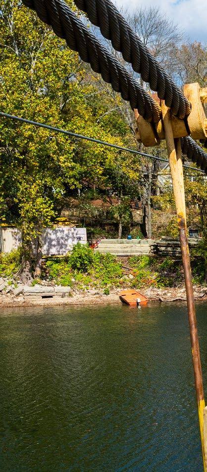
ICO N IC BEAVER BRIDGE GETS A FACELIFT
T
BY DAVID NILLES
HERE ARE VERY FEW BRIDGES IN ARKANSAS AS UNIQUE AS THE HIGHWAY 187 BEAVER BRIDGE OVER THE WHITE RIVER AT TABLE ROCK LAKE.
By driving a few minutes outside of
Eureka Springs and crossing over the bridge, you quickly become convinced of that. Maybe it is the fact that it is a onelane suspension bridge or, more likely, it is the sound of the clickety clack as you drive over the bridge’s wooden timbers. Known as the “Golden Gate of the Ozarks,” it is an Arkansas treasure. ArDOT engineers appreciate how unique the bridge is and work hard to be certain it is maintained in top condition. That includes occasionally replacing those famous timbers. Crews with ArDOT’s Heavy Bridge section began working on the timbers in early September of 2020. “Between the weather and the traffic,
from May 24 to July 22 of 2020 due to high water.
GETTING TO WORK The last time the timbers were replaced was in 2001. New timbers for the bridge were shipped in from Lake Charles, Louisiana. In addition to replacing the timbers on the bridge, the railings will be replaced as well. Steel beams on the bridge will be cleaned and inspected, and the familiar yellow towers will receive a fresh coat of paint. It is estimated the work will take three months to complete. “I would estimate the new timbers will last between 15 and 20 years,” Lawrence added. “The bridge has been going under water more frequently in the past
there has been deterioration of the
10 years due to heavy rains and flooding,
wood over the years,” stated District 9
and that has undoubtedly affected the
Engineer Steve Lawrence.
condition of the current deck timbers.
A HISTORY OF THE BRIDGE Crews with Carroll County constructed the first bridge over the White River at Beaver in 1926. Prior to that, a ferryboat, established by Wilson A. Beaver in 1850, carried vehicles across the water. After a flood destroyed the original bridge in 1943, the Arkansas Highway Commission approved construction of the bridge that we see today. The Pioneer Construction Company of Malvern completed the work. Here are a few fun facts about the
If this trend continues, it will most likely
bridge. As a suspension bridge, how
each day and it has survived flooding a
affect the lifespan of the new ones being
much weight would you guess it could
few times. In fact, the bridge was closed
placed.”
hold? The bridge has a weight limit of
Hundreds of vehicles cross the bridge
20 || WWW.ArDOT.GOV/MAGAZINE.ASPX
10 tons. It was added to the National Register of Historic Places in 1990. The bridge was featured in the 2005 movie Elizabethtown that included a scene of Orlando Bloom on the bridge dropping ashes from an urn into the water below. Today, the bridge is known as the “Bridge to Nostalgia” and is the last suspension bridge of its type open to vehicular traffic in Arkansas. With new timbers in place, the Golden Gate of the Ozarks is ready to serve motorists for many more years to come. ARKANSAS HIGHWAYS MAGAZINE | WINTER 2021
|| 21
SPECIAL EVENTS AROUND THE STATE
BY BRITNI PADILL A-DUMAS & DAVID NILLES
VETERANS MEMORIAL BRIDGE PULASKI COUNTY People gathered near Dickey Stephens Park Wednesday, October 21 to dedicate the Highway 70 Broadway Bridge as the Veterans Memorial Bridge. The Arkansas Veterans Coalition (AVC) collaborated with the cities of Little Rock, North Little Rock and ArDOT to rename the bridge to recognize the commitment and service of our armed forces in Arkansas. The original Broadway Bridge was dedicated to veterans of World War I in 1923. After 90 years of useful service, the bridge was replaced in 2017. The new bridge is dedicated to all Arkansas Veterans—past, present, and future—for their selfless service and dedication to duty while serving in the Armed Forces of the United States.
U.S. HIGHWAY 82 ASHLEY COUNTY Local dignitaries, ArDOT staff and Highway Commissioners came together south of Hamburg to cut a ribbon on the completion of the widening of a section of Highway 82. The five-mile project widened Highway 82 to four lanes beginning at County Road 411 near Hamburg and extending southward to Highway 425. JB James Construction, LLC, was awarded the $26.7 million contract in September 2018. “When I look at a map of this newly widened highway and plans for it to the west, it assures me that ArDOT is indeed achieving its goal of widening and improving highways in every corner of this state,” Arkansas Highway Commission Chairman Robert S. Moore, Jr. of Arkansas City told the crowd. An additional project currently under construction is widening Highway 82 to four lanes extending from Highway 425 westward towards Crossett.
HIGHWAY 412 PARAGOULD BYPASS PARAGOULD A crowd that included Governor Asa Hutchinson gathered for a ribbon cutting on the western section of the Highway 412 Bypass in Paragould. The new five-mile section connects with the eastern section to complete the ten-mile, two-lane route south of town. Dumey Contracting, Inc. completed the construction at a cost of $12.7 million. “It takes vision and perseverance to complete highway projects such as this,” stated Highway Commission Chairman Robert S. Moore, Jr. Governor Hutchinson told the crowd that he appreciates value and working hard for economic development in Arkansas. “The Highway 412 corridor is a key part of our future growth plans in Arkansas,” Hutchinson added. “Whether it is farm to market, or school buses driving on safe roads, or our tourism industry, they all need the benefit of good highway infrastructure. Whenever we cut a ribbon, it says ‘go’ and to me ‘go’ means growth and opportunity. So let’s get ready to ‘go’ when we cut this ribbon.”
22 || WWW.ArDOT.GOV/MAGAZINE.ASPX
WHAT LIES BENEATH THE PAVEMENT:
Caves of Arkansas BY BRITNI PADILL A-DUMAS
A
S YOU TRAVEL A BEAUTIFULLY PAVED HIGHWAY THAT WINDS ITS WAY THROUGH ARKANSAS FORESTS, HAVE YOU EVER WONDERED, “WHAT IS UNDER ME, RIGHT HERE, RIGHT NOW?”
No? Just me? That’s fine—we’re going to dig a little deeper, anyway.
Blanchard Springs Caverns
Highways are known to stretch across valleys, fields, bodies of water, swamps, marshes,
mountains and rock formations. But what about cruising above the unseen?
Arkansas is home to several living caves hidden beneath our driving surface. Many of
these caves are located in or near the Ozark National Forest in Northwest Arkansas.
Blanchard Springs Caverns • Below Highway 14 Fifty Six, Arkansas
Blanchard Springs Caverns is located in the Ozark National Forest, just 15 miles
northwest of Mountain View on Arkansas Highway 14. Pitch a tent in the campgrounds and choose which underground trail you will explore. This living cave is a constant 58 degrees Fahrenheit, so dress accordingly.
Cosmic Cavern • Beneath Highway 21 North Berryville, Arkansas
The state’s warmest cave clocks in at 64 degrees Fahrenheit. Discovered in 1845, it is
home to two cave lakes, neither known to have a bottom. The trout that have lived in the
lake for nearly 50 years have lost their eyesight and coloring because the water is so dark and deep.
Mystic Cavern & Crystal Dome • Under Highway 7 Harrison, Arkansas Cosmic Cavern
Travel 110 feet below the surface to a cave discovered in 1967. The “Pipe Organ” in this
underground chamber is one of the most spectacular calcite formations, standing 30 feet tall and 12 feet thick!
Old Spanish Treasure Cave • Below Highway 59 Sulphur Springs, Arkansas
If “watch a movie inside a treasure cave” is on your bucket list, you’re in luck! Featured
on an episode of Unexplained and Unexplored on the Discovery Science Channel, the Old
Spanish Treasure Cave boasts legends of buried treasure by the Spanish Conquistadors. It is believed that the treasure is still here.
War Eagle Cavern • Beneath Highway 12 War Eagle, Arkansas
While visiting the historic War Eagle area, experience the largest cave entrance located
along a lakeshore with your furry, four-legged children. The cavern tours are pet-friendly
as long as everyone is on their best behavior. A portion of the film Frank and Jesse starring Rob Lowe, Bill Paxton and Randy Travis was filmed inside the cave. Can you find evidence of Travis’ visit?
Photo credits: Blanchard Springs Caverns courtesy of Arkansas Parks & Tourism; Cosmic Cavern courtesy of CosmicCavern.com; Mystic Cavern & Crystal Dome courtesy of MysticCaverns.com
Mystic Cavern & Crystal Dome
ARKANSAS HIGHWAYS MAGAZINE | WINTER 2021
|| 23
THE TOAD SUCK FERRY RETURNS HOME BY DAVID NILLES
147
YEARS. That is how long a ferryboat operated at Toad Suck, Arkansas, carrying passengers across the Arkansas River between Faulkner and Perry Counties. When Lock and Dam #8 and the Highway 60 Bridge were dedicated on September 27, 1970, the modern day ferry made its last trip across the river. The vessel’s years of service were not over, however. The Arkansas Department of Transportation (ArDOT) moved the ferry to Peel to transport passengers across Bull Shoals Lake. After many years of operation in northern Arkansas, the faithful vessel recently returned home to Toad Suck.
was just large enough for an operator,
is on display today at Toad Suck Ferry
and a horse and rider and was pushed
Damsite Park.
A HISTORY OF RIVER CROSSINGS
that during his ownership in the 1930s,
across the water with a pole. In the years that followed, numerous
In 1953, Senator Jones received a $20,000 legislative appropriation for
methods were used to assist the ferry
state operation of the ferry. H.B. Smith
across. A cable was stretched from
Welding Company of Dumas built a new
shore to shore towards turn of the 20th
ferry made of steel in 1956. A replica
century to pull the ferry to the other
of the ferry and its actual motor can be
side. Soon, two low-powered motors
seen at the Faulkner County Museum.
were used to guide the boat. The ferry was privately owned through most of its history. Senator Guy “Mutt” Jones of Conway, Representative Paul
Today, the actual ferry has returned as well.
THE JOURNEY HOME
Van Dalsem, Conway businessman Dave
The Toad Suck Ferry began operation
Ward and the Conway Y.B.M.A. (Young
on Bull Shoals Lake in 1970. After many
Business Men’s Association) were
years of carrying motorists in northwest
among the various owners.
Arkansas, it was retired. The vessel still
Representative Van Dalsem recalled it was a wooden barge. He hired
had one final trip to make, one that would take it back home to Toad Suck. "The City of Conway and Faulkner
Conway mechanic Dave Ward to build a
County first contacted ArDOT about
began service in 1823 when a postal
steel barge and jon boat. The jon boat
acquiring the barge in late 2015
route to Hot Springs was established. It
towed the ferry until the late 1940s and
after the Christmas Barge was put
The first ferry to operate at Toad Suck
24 || WWW.ArDOT.GOV/MAGAZINE.ASPX
into service at Peel,” recalled Steve
the District 9 Headquarters on October
minimum number of stops. Getting the
Lawrence, District 9 Engineer.
22. That was a good opportunity for us
barge there safely was our number one
to make sure everything was going to
goal and crews did a great job of that!”
Plans soon began to materialize for a move back to Toad Suck. The journey
function as we were anticipating. It also
would require the efforts of ArDOT
helped us with traffic control planning
Peel Ferry, District Shop, Bridge, and
for the bigger move down Highway 65
Sign crews. Highway Police had officers
on October 25.”
from AHP Districts 2 and 4 helping with
District 9 personnel, Arkansas Highway Police, the City of Conway and the offices of Faulkner County. A checklist
Personnel started gathering early that
for moving day would require a lowboy
Sunday and crews left at about 7:00 a.m.
trailer, a crane to lift the barge onto the
"The portion of Highway 65 between
District crews involved included: the
the move. The barge arrived at the park around noon that day. Today, the ferry stands in Old Ferry
trailer, crews to make the move and law
Western Grove and Marshall was the
Landing Park, a matter of yards from
enforcement escorts for the 130-mile
most challenging part of the move
the Arkansas River where it once
trip back to Toad Suck.
due to the narrowness of the road,”
operated. The boat will be restored to
Lawrence added. “We had vehicles out
its original appearance with a fresh coat
front stopping and flagging traffic so we
of orange paint, a new wheelhouse and
could “hopscotch” the barge down the
paddlewheels.
On October 22, 2020, the ferry began its final journey. ArDOT crews traveled to Peel, lifted the vessel onto a flatbed truck and drove to District 9 Headquarters in Harrison. On October 25, the boat was transported back to Faulkner County. "The move went very well due to superb planning and coordination
road without encountering oncoming
by can see the barge and recall those
were able to move without stopping
earlier rides across the river.
traffic. We did have to pull over occasionally to let traffic by that was caught behind us.
Old Ferry Landing Park is located off Highway 60 on the eastern bank of the Arkansas River.
"The Highway Police did a great job of
between District forces and Highway
controlling traffic when we approached
Police personnel,” Lawrence shared.
narrow bridges and traffic lights. That
"We moved the barge from Peel to
Those that rode the ferry in days gone
vehicles. Once we got to Marshall, we
allowed the move to continue with a
*Historical information for this article was provided by the Faulkner County Historical Society and Cindy Beckman, editor of the “Faulkner Facts and Fiddlings” journal.
ARKANSAS HIGHWAYS MAGAZINE | WINTER 2021
|| 25
Maintenance Crews:
ON LOCATION DIS TRIC T 10
“The ability to hold and store salt in larger quantities helps to make sure we can be equipped for winter events when needed,” Smithee added. “When we see multiple events follow one another, our supply can deplete rapidly and having larger storage capacity helps during those unfortunate times. Additionally, by building larger facilities and strategically locating them, this allows us to be able to transport materials around our District during times we find it difficult to receive deliveries from our supplier.” The Greene County facility is ideally located very near the District 10 headquarters. Crews begin their shifts by loading at the Paragould area headquarters before heading to their designated routes. “In addition, Greene County is our crew that manufactures our brine and has our largest tank farm for brine storage. The ability to store more salt will simply help to assure more materials are available for all needs,” Smithee added. Bulk pretreated rock salt for the new storage facility will be supplied by Oakley Fertilizer in North Little Rock in
A
accordance with current Department supply contracts. NEW SALT STORAGE FACILITY IS BEING CONSTRUCTED IN PARAGOULD AT DISTRICT 10’S GREENE COUNTY AREA HEADQUARTERS.
Smithee commented on the importance of storing adequate supplies of salt. “When I started with the Department over 32 years ago,
The old storage structure was 25 years old and the salt it
winter weather was something we just didn’t have to
held had taken a toll on the facility.
address often. We had events that lasted for a few days,
“The walls had deteriorated, the roof shingles were past
but our citizens knew that it would melt away soon. Today,
their usefulness and the decking had many bad panels,”
those ideas are long gone and, statewide, we place a
District Engineer Brad Smithee shared.
huge emphasis on our efforts, equipment and materials
The concrete floor and walls of the new building were
for possible winter weather events. While there are many
constructed by Palmer Construction of Pocahontas.
materials that can be used to pre-treat and fight roadways
A rDOT maintenance crews are installing the ClearSpan
and bridges that find themselves becoming slippery during
fabric/truss roof. The entire building process is expected to
icy weather, bulk salt has been, and will be, the most widely
take approximately eight weeks.
used product in the effort to improve conditions on our
The new facility will be bigger and better, holding up to 2,000 cubic yards of salt, a significant increase over the old one.
26 || WWW.ArDOT.GOV/MAGAZINE.ASPX
transportation system.” Estimated cost of the new storage facility in Greene County is approximately $137,000.
DIS TRIC T 2 Intersection of Highway 82 and Highway 425
T
CORNER hree construction projects in Ashley County are improving Highways 82 and 425 near Hamburg and Crossett.
A ribbon cutting took place October 1 on a project that
widened five miles of Highway 82 to four lanes between Hamburg and Highway 425 to the south. J.B. James Construction, LLC, completed the project at $26.7 million. “These improvements in southeast Arkansas are all a part of providing the best highway system possible for motorists,” stated Commission Chairman Robert S. Moore, Jr. at a ribbon cutting ceremony. “Highways that are safer, that have less congestion and that are part of improving economic opportunities withinour borders.” The project on Highway 82, between Hamburg and Highway 425, is part of ArDOT’s Connecting Arkansas Program. Widening continues on Highway 82 to the west of the junction with Highway 425. Crews with Johnsville Company, LLC, are widening a five-mile section that extends westward into Crossett. Work on this section of the highway is to be completed in late 2020. Another Connecting Arkansas Program project in the same area is widening approximately ten miles of Highway 425 from Highway Leveling the surface on Highway 82
82 southward to the Louisiana border. Diamond B Construction Company, LLC, was awarded the contract at approximately $44.6 million. These improvements are scheduled to be complete in the summer of 2022.
Laying asphalt on Highway 82 ARKANSAS HIGHWAYS MAGAZINE | WINTER 2021
|| 27
PRSRT STD U.S. POSTAGE
PAID
Arkansas Department of Transportation P.O. Box 2261 Little Rock, AR 72203-2261
Little Rock, AR 72203 Permit No. 2556
FORWARDING SERVICE REQUESTED