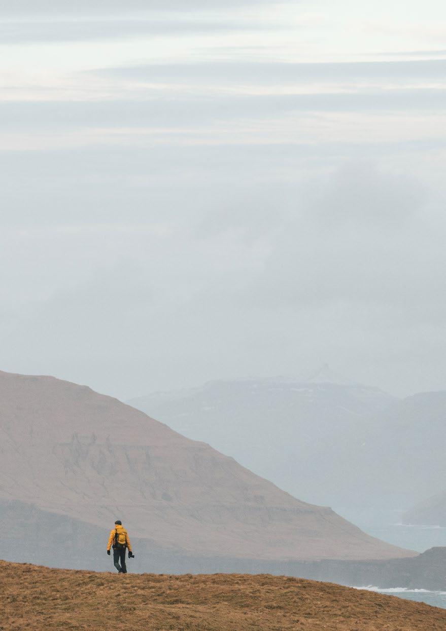
Your
 essential hiking guide

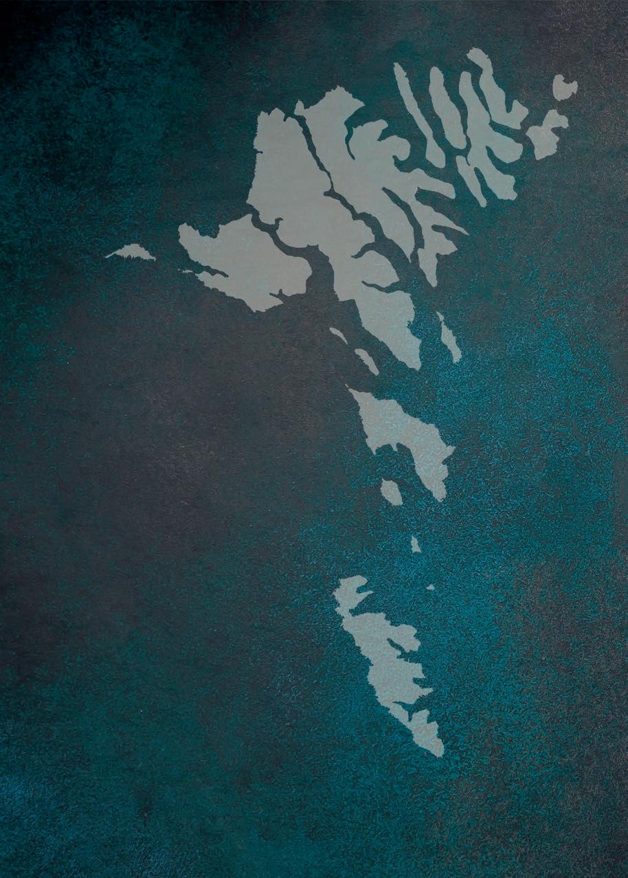
1 2 4 3 5 6 7 9 10 11 12 13 14 15 16 17 20 18 19 8
Text: Óluva Zachariasen, Randi Meitil, Óli Gardshodn.
Translations and proofreading: Sprotin.
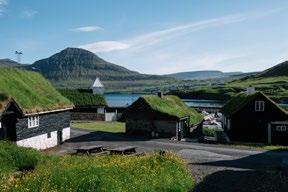
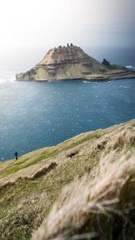
Cover photo: Daniel Villadsen.
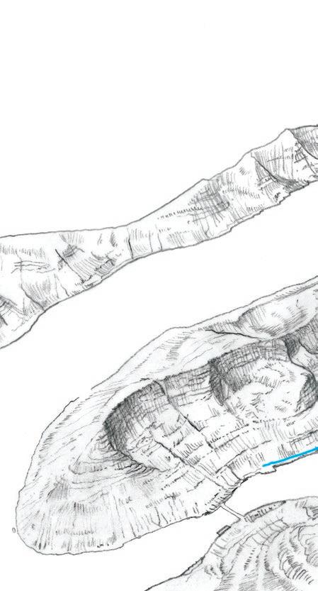
Map Design and Illustrations: Peita Blythe with Lew Keilar.
Photos: Marc Chesneau, Mitch Wies, Rob Ash, Mads Tolstrup, Paolo Sartori, Valentin Manhart, Kirsten Vang, Alessio Mesiano, Saviour Misfud, Jack Watson, Daniel Casson, Kai Hornung, Dávur Djurhuus and others.
Design and printing: Sendistovan.
Copyrights© Permission is required from publisher and author to reproduce text. Permisson is required from photographers to reproduce photos.
1 5 15 9 19 2 6 16 10 20 3 13 7 17 11 4 14 8 18 12 Klaksvík – Árnafjørður 16 Haraldssund - Skarð 18 Leirvík – Norðragøta 20 Fuglafjørður – Hellurnar 22 Elduvík – Oyndarfjørður 24 Skálafjørður – Oyri 26 Saksun – Tjørnuvik 28 Hvalvík – Vestmanna 30 Tórshavn – Kirkjubøur 32 Leynar – Kollafjørður 34 Skælingur – Norðradalur 36 Nólsoy – Borðan 38 Bøur – Gásadalur 40 Vatnsoyrar – Miðvágur 42 Sandavágur – Slættanes – Gásadalur 44 Sandur – Søltuvík 46 Guðrunarløkur – Skarvanes – Dalur 48 Hvalba – Trongisvágur 50 Tvøroyri – Hvannhagi 52 Fámjin – Vágur 54 Welcome 5 Introduction 6
CONTENTS
Published
Faroe
í Gongini
Tórshavn,
and distributed by: Visit
Islands,
9, P.O. Box 118, FO-110
Tel. +298 666 555 www.visitfaroeislands.com.
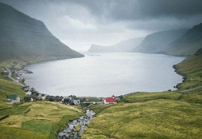
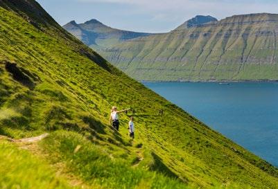
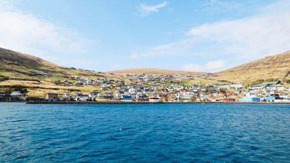
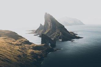
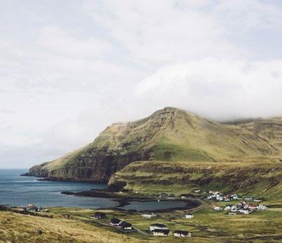
VÆLKOMIN
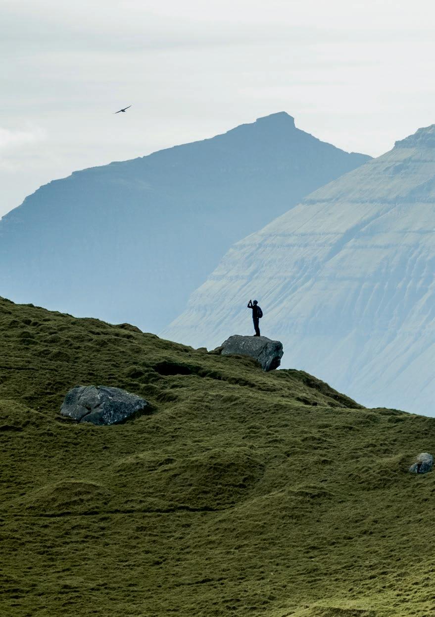
Windswept mountains, lush valleys, and gentle rivers. This hiking brochure guides you to some of the most iconic hikes along the ancient village paths of the Faroe Islands.
VÆLKOMIN
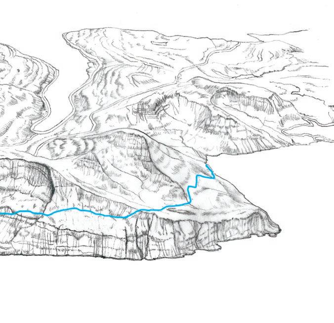
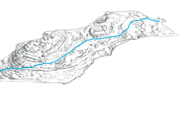
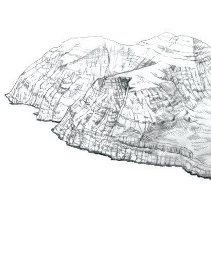
We’ve selected 20 hiking paths in varying length, terrain, and difficulty level. The routes are illustrated with hand-made drawings giving you a bird’s eye view of the surrounding area, and supplemented with descriptions, facts, and stories. The maps invite you to explore and enjoy other attractions and sights in the surrounding area.
FOR MORE HIKES AND LONGER DESCRIPTIONS as well as access to gpx-files for mobile devices, essential for many of the routes go to www.visitfaroeislands.com/hiking
THE VILLAGE PATHS
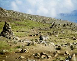
Before paved roads and tunnels people travelled on foot paths over mountainous terrain. These paths are generally marked with cairns, a heap of stones, set up as landmarks showing the way. This ancient network is today known as varðbøgur (cairnpaths) or bygdagøtur (villagepaths). People wore shoes made of cow or sheep hide, so it was important to lay the path through dryland. Finding the right route – if not the shortest, then the most convenient – between villages was a priority.
The distance between the cairns varies, depending on the terrain. If sudden fog or snow appeared the humble cairn could be lifesaving. These days travellers are advised not to add rocks to a cairn or to build new ones, to preserve the historic village paths.
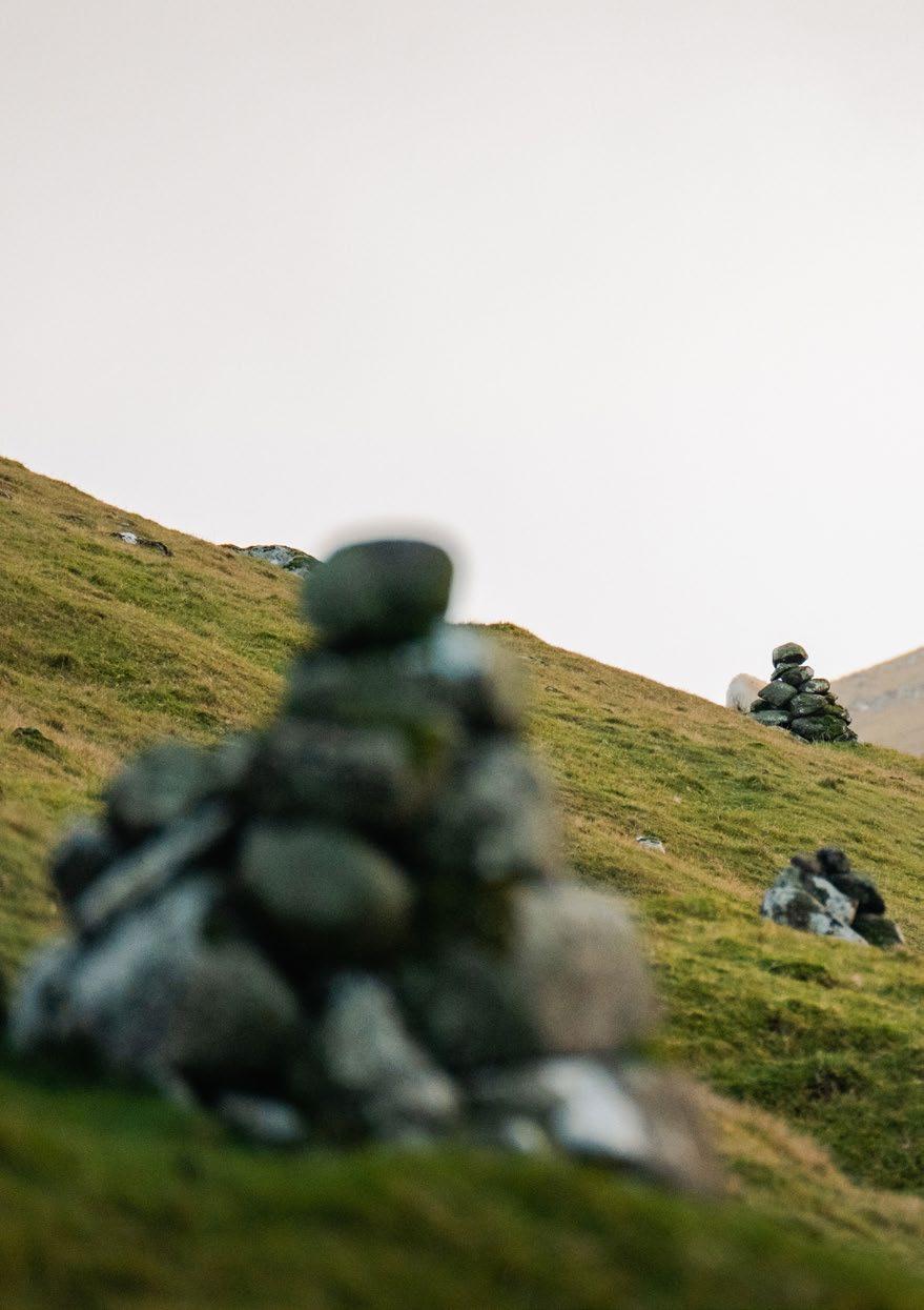
In some places, the cairns can be hard to see, while the path is clearly visible. On some routes, the direction of the path is marked with poles. There are, however, stretches without cairns, clear paths or poles. Please bring a map and download digital gpx files to your mobile devices, so you never get lost.
PUBLIC TRANSPORT
When hiking from one village to another you might need assistance from the modern public transport system. See travel plans for buses and ferries on www ssl fo or contact the regional tourist information.
6 HIKING INTRODUCTION
FAUNA AND CULTURAL HISTORY
The Faroe Islands are famous for hosting an abundant birdlife: Curlew, Snipe, Plovers, Oystercatchers, Skuas, Great Skuas, Ravens and Crows. Sheep, geese and hares are also common. In the outfield, you see traces of how people lived and got by in the old days. Stone outhouses, boat houses, old field strips, peat fields and turf store houses. Old infield walls, drovers, sheep pens, sheep shelters, sheep houses and so-called Fransatoftir (Frenchman’s Ruins, which are ruins of small houses where people took refuge from pirates in the old days), tell stories of a long-gone traditional peasant society.
The outfields are still used for sheep herding, so you will see fences, marking different properties of land. Please have respect for these fences and try to find a suitable crossing, where you don’t have to step on the fence.
Sheep herding is a regular activity in the Faroese mountains. It varies from place to place, when farmers herd their sheep. Hare-hunting season is on from 1. november to 1. January and many outfields are closed for visitors. It is most common to hunt on Saturdays and prohibited on Sundays.

IF IN DOUBT
please ask a local information office if sheep herding or hare hunting can affect your hiking trip.
7 HIKING IN THE FAROE ISLANDS
LEAVE NO TRACE
• Follow the cairns or other marks Do not go off the paths
• Leave outfield gates as you find it
• Do not disturb the sheep, birds and plants
• Dogs must not be taken into the outfields
• Leave rocks, plants and other natural objects as you find them
• Camping is only permitted at designated campsites
8 HIKING INTRODUCTION
DURATION AND DIFFICULTY
Each route is marked with a time indication that shows the duration of the walk. The time estimation is based on how long it takes an adult with normal walking speed to walk the route. Meal breaks or other stops are not included. The difficulty level is assessed on how steep the terrain is, if the surface is flat or uneven, and how long the route is.
EASY
Easy and safe to walk for everyone.
MEDIUM
Easy Medium Challenging Expert
Requires basic hiking skills on uneven and varying terrain, sometimes including steep and challenging stretches on the route.
Easy Medium Challenging Expert
CHALLENGING
For experiences hikers with necessary stamina, physical condition and right hiking equipment. The terrain can be challenging and might include climbing, crossing rivers etc. Height and length may vary.
Medium Challenging Expert
EXPERT
Only suitable for very experienced hikers with the necessary physical and mental condition to tackle dangerous terrain. You need good hiking equipment and climbing skills.
Challenging Expert
9 HIKING IN THE FAROE ISLANDS
DRESS FOR THE WEATHER
• Always wear clothes suitable for the weather
• It is recommended to use walking shoes/boots with rough bottoms. Rubber boots with rough bottoms can also be used
• Remember to charge the battery of your phone and maybe bring a power bank (extra charge) on long trips. Note that there is no telephone connection on some stretches in the outfield
• Head lamp, compass and whistle can be useful in an emergency or if you are surprised by fog/ darkness
• Always bring food, drink and something sweet - also for short trips
10 HIKING INTRODUCTION
11 HIKING IN THE FAROE ISLANDS Daylight Dawn and dusk
00.00 JAN FEB MAR APR MAY JUN JUL AUG SEP OCT NOV DEC 02.00 04.00 06.00 08.00 10.00 12.00 14.00 16.00 18.00 20.00 22.00 00.00
DAYLIGHT HOURS VARY SIGNIFICANTLY THROUGHOUT THE YEAR
SAFETY FIRST
• Notify your host about where you plan on hiking. Please let them know when you have arrived at the destination
• Always walk with others
• Be particularly careful in areas with loose stones and rocks, especially if traveling in a group

• Do not go too close to the cliffs; especially when the ground is slippery
SAFE TRAVEL
Pamphlets are available at regional information centres where you can add contact details and hiking plans to leave at your place of accommodation
EMERGENCY NUMBER
Dial 112 for any type of emergency assistance anywhere in the country
12 HIKING INTRODUCTION

13 HIKING IN THE FAROE ISLANDS
HIKING ROUTES
ROUTES
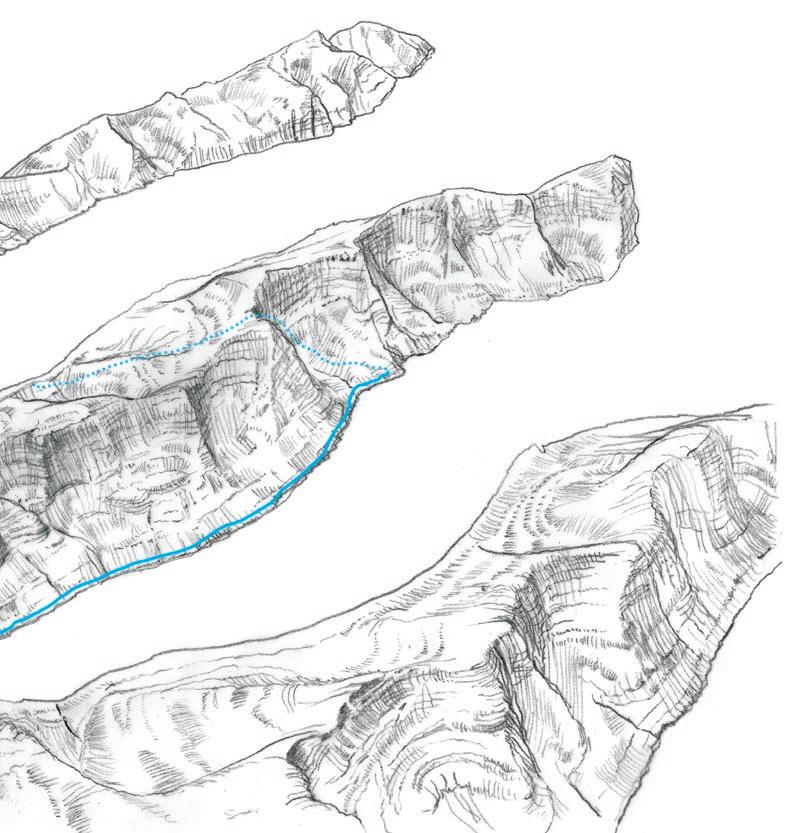
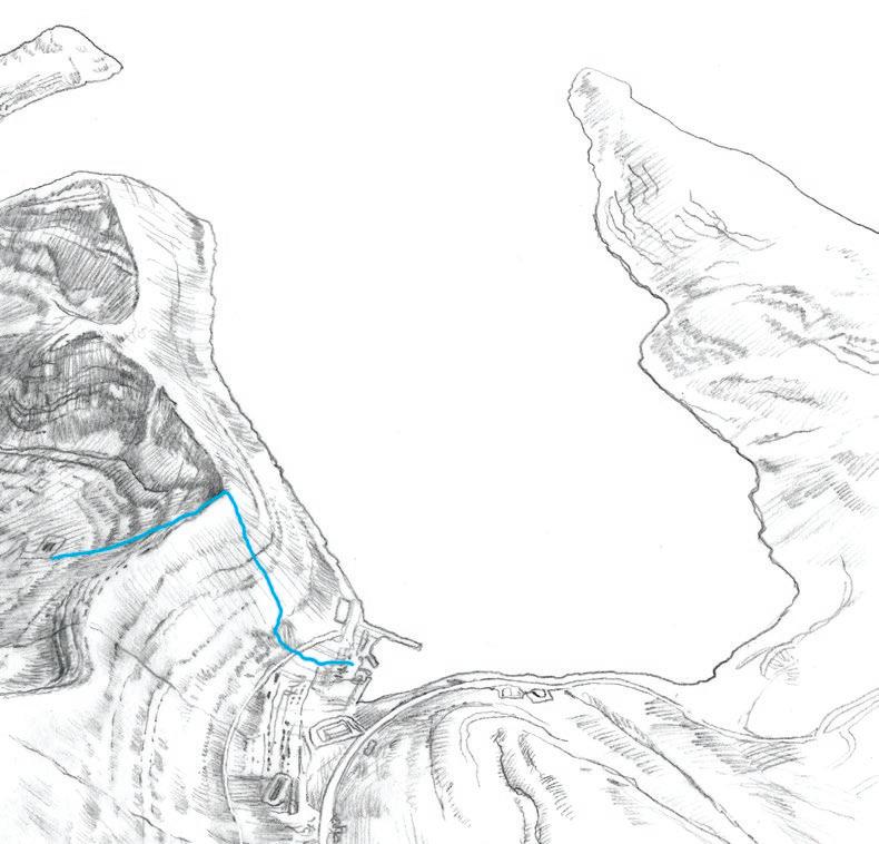
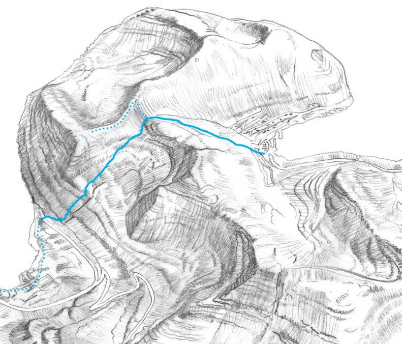
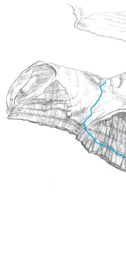
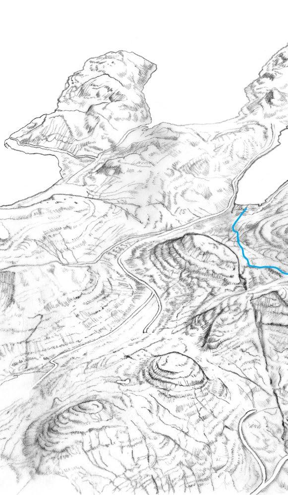
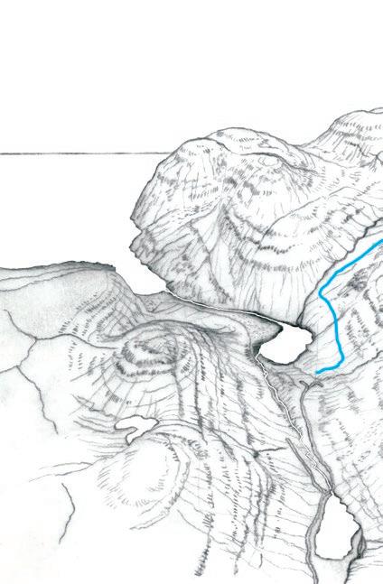
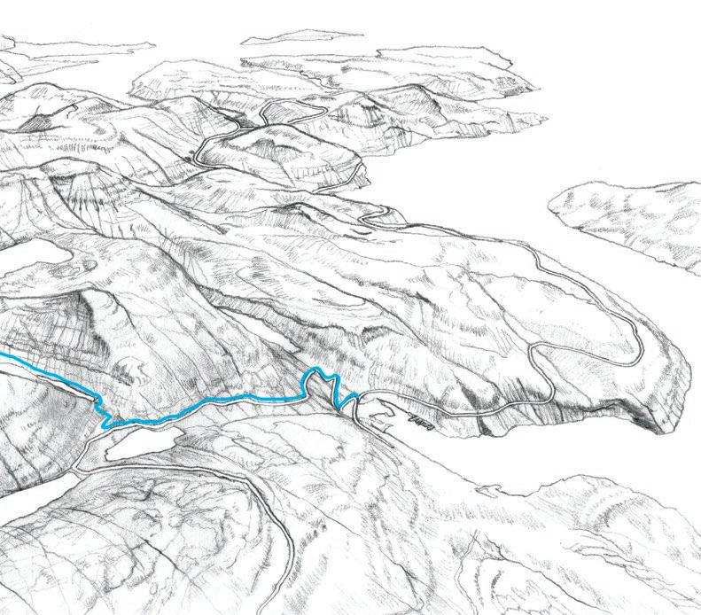
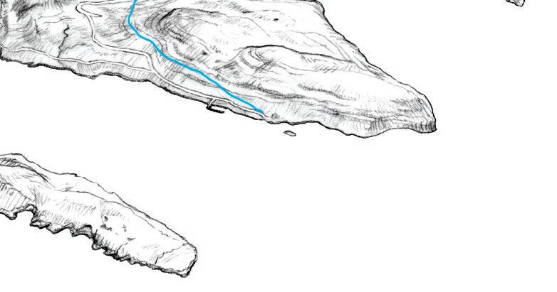
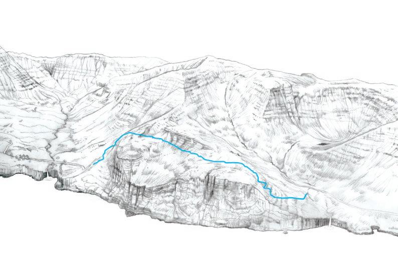
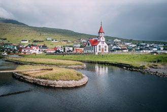
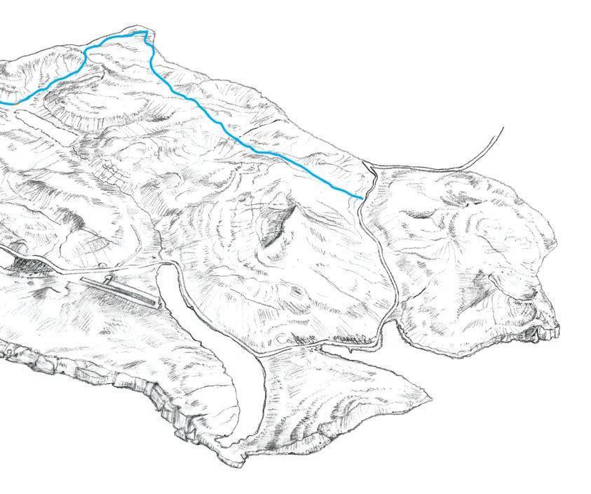
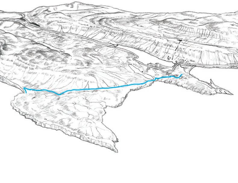
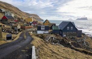
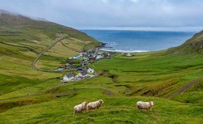
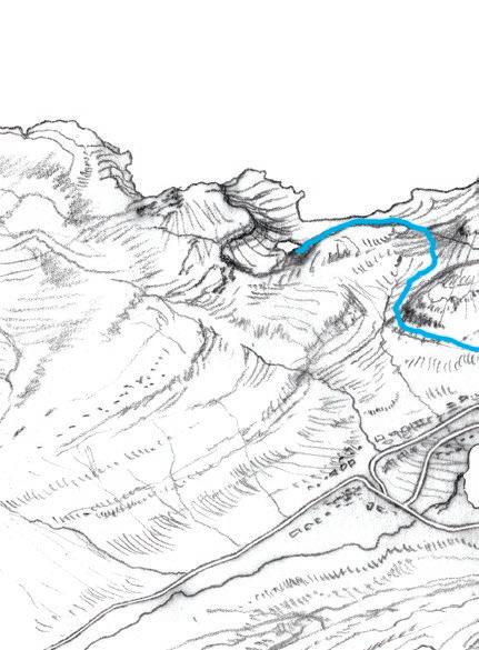
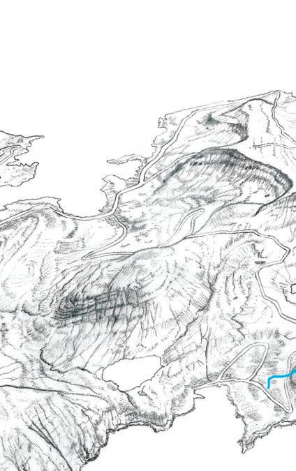
KLAKSVÍK –ÁRNAFJØRÐUR
Enjoy the magnificent views on the historic trail between Klaksvík and Árnafjørður, in the centre of the Northern Isles region. From Klaksvík you step on the outfield that used to be administrated by the national hero Nólsoyar Páll (1766-1809), a captain, farmer and poet, who was a pioneer for faroese progress and prosperity. The farmhouse of Nólsoyar Páll has been carefully reconstructed in the centre of Klaksvík.
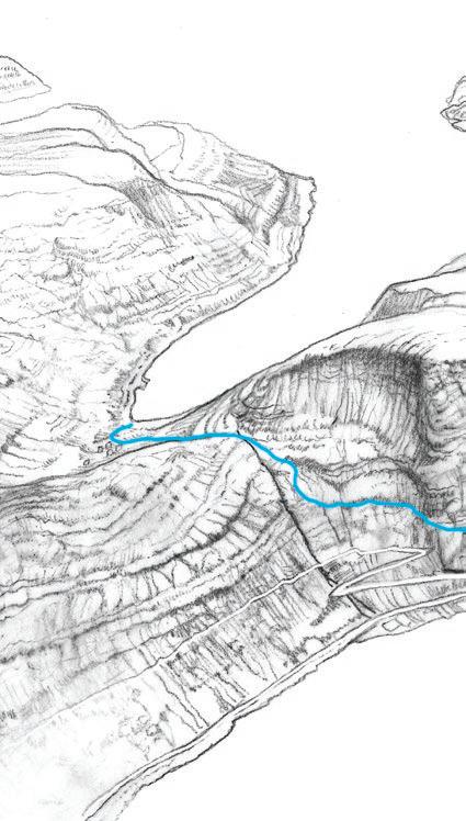
As you climb uphill towards the maximum height of 429 meters, the landscape becomes increasingly more rugged and steep Follow the cairns but be very careful as the terrain is steep in some places. You will pass a boulder named Grindasteinur — Pilot Whale Boulder. According to legend it was here that news of a pilot whale hunt would be shouted down to Árnafjørður, hence the name. Árnafjørður is one of the oldest villages in the northern islands today famous for its beach and lobster rich fjord.
The hike can be taken in either direction. The first ascent is more strenuous if starting in Árnafjørður. Take a detour to Katlarnir - Katlarnir was the local Thing for the northern islands for centuries, where sentences were passed in various disputes and crimes. Parliament was in session during the spring. We don’t know when it started, but there are signs that it ended around 1670-80. In addition to the great Thing Stones, there are smaller stones scattered on the rocky plateau, which were probably used for issues related to the Thing. To reach Katlarnir you must go diagonally down into the valley. There are cairns, but some of them are difficult to spot.
Scan for more information about the hike & to see the digitial interactive map
16 KLAKSVÍK – ÁRNAFJØRÐUR
Grindasteinur
1
Árnafjørður
Katlarnir
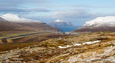
17 HIKING IN THE FAROE ISLANDS Klakkur Klaksvík 3.0 Di cult TRAIL DIFFICULTY Challenging 5 km (one way) 2 hrs (one way)
Photos are marked where they were taken
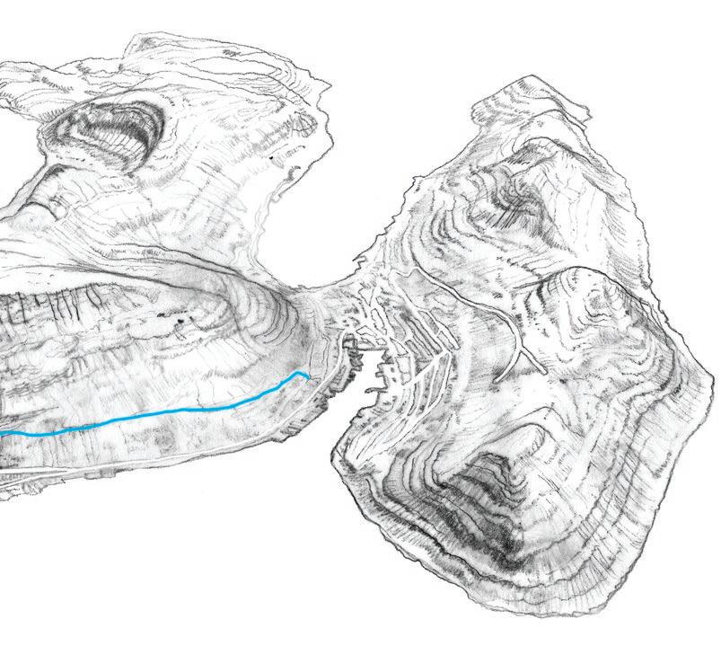
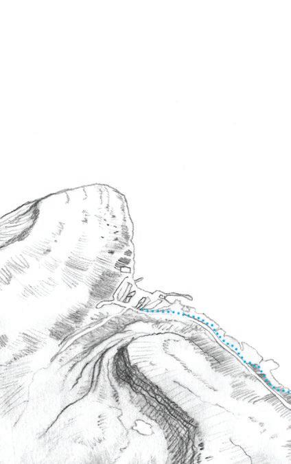
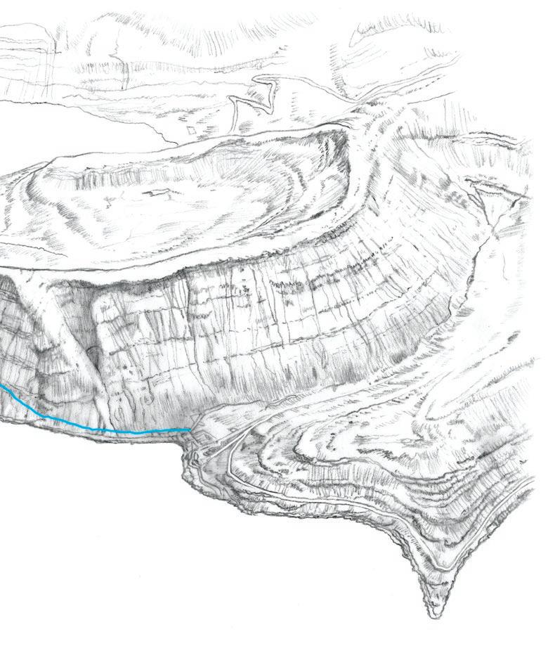
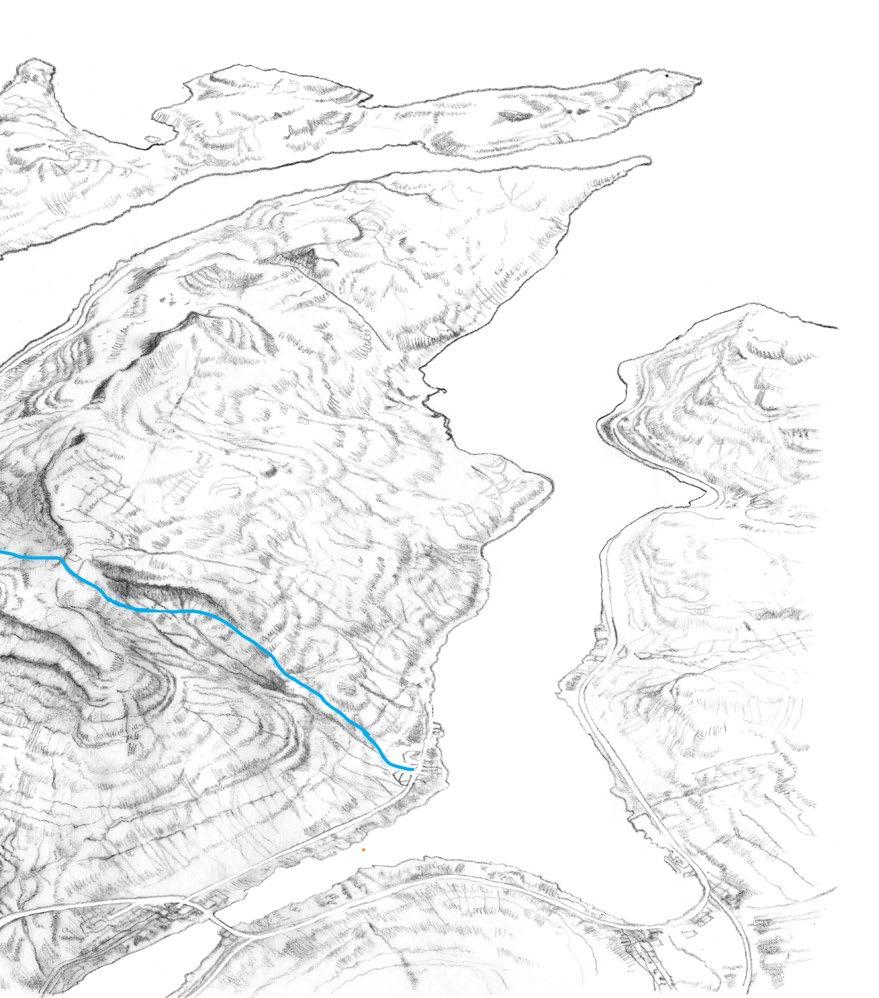
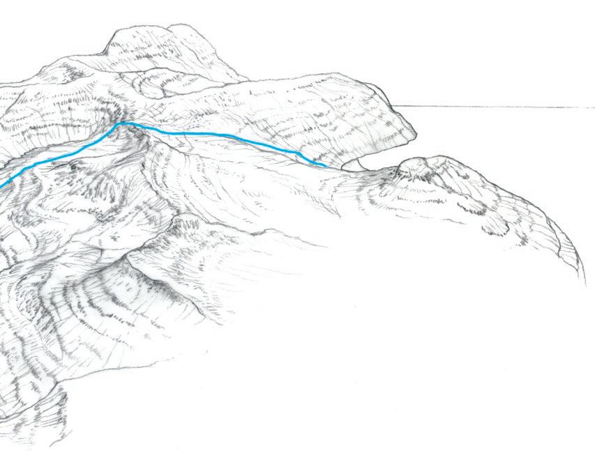
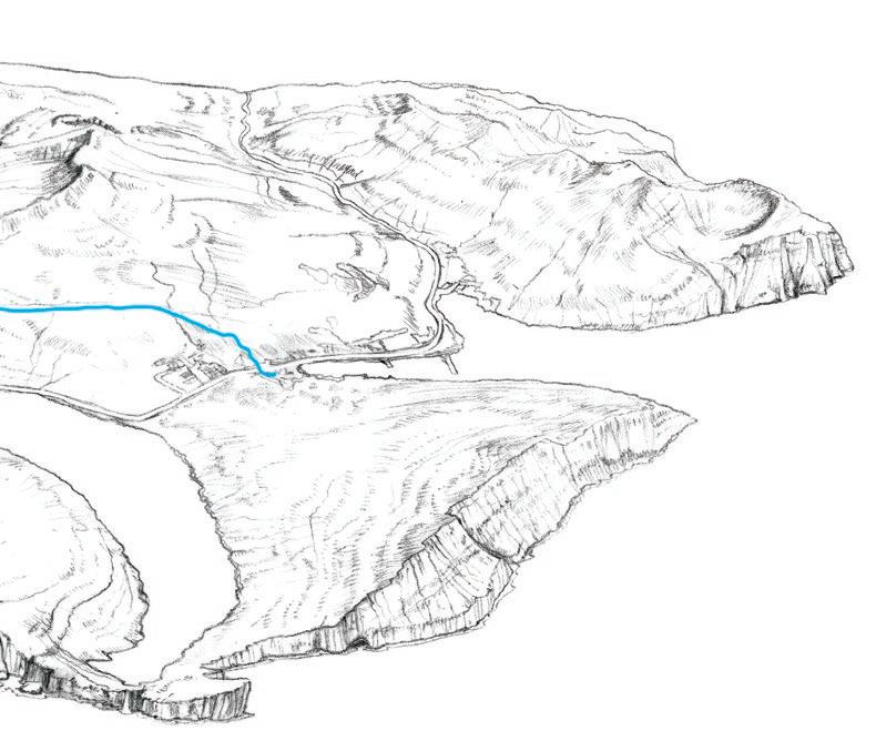
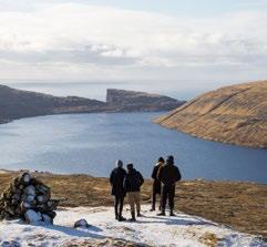
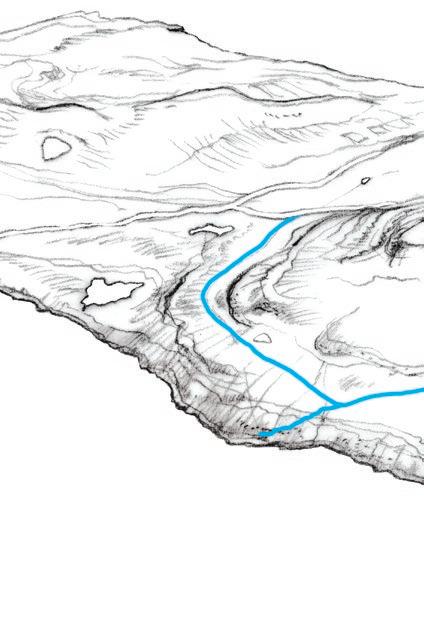
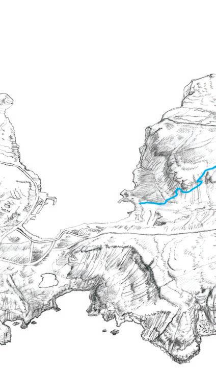
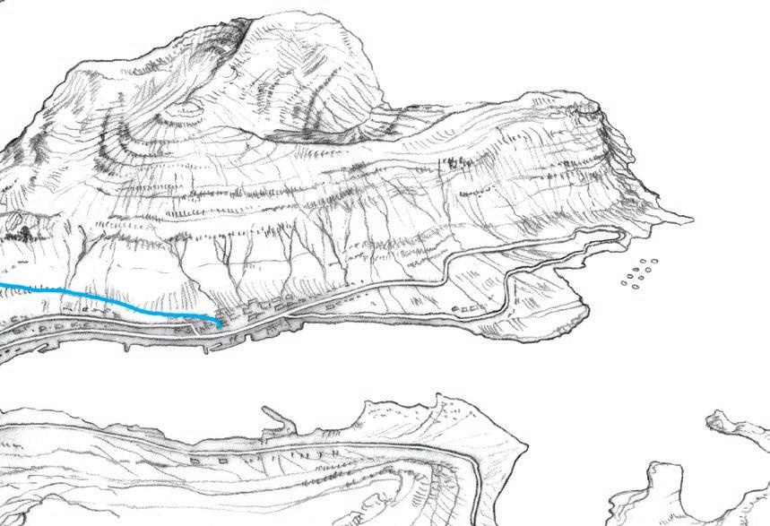
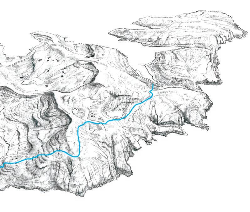
HARALDSSUND - SKARÐ
The route begins in the northernmost point in the village of Haraldssund. It can be a bit difficult to find the path, but as you walk along the coastline, it will become clearer.
Several gullies and streams are on the route northwards. Be careful where the rocky ground is slippery.
Kunoy is on average the highest island in the Faroe Islands and has six of the ten mountains that rise above 800-meters.
Many areas are not walkable, and we advise you not to wander into the mountains without an experienced guide.
After five kilometres, you will see Skarð and the ruins of the houses that appear minuscule down by the coastline. Right above you are the magnificent gorge and mountain pass. There was no church in Skarð, so the locals would have to walk through this gorge to attend church in Kunoy.
If you decide to hike from Skarð to Kunoy through the gorge reaching an elevation of 618 metres, we only recommend doing this with an experienced guide. The route is challenging and potentially dangerous if you take the wrong path. This route is only suited for very experienced and fit hikers.
Skarð has had an exceptionally hard fate. In a series of three accidents, several local men were lost at sea. The last accident hit the day before Christmas Eve in 1913 when a storm suddenly broke, and the boat of Skarð along with the seven men on board perished. Life became so difficult that the village was abandoned in 1919. A memorial in remembrance of those lost at sea has been erected in Skarð. The villagers relocated to Haraldssund, and timber frames from Skarð can still be found in two of the houses there.
Scan for more information about the hike & to see the digitial interactive map
18 HARALDSSUND – SKARÐ
Haraldssund
2
TRAIL DIFFICULTY Difficult
12 km (both way)
4 hrs (one way)
19 HIKING IN THE FAROE ISLANDS
Kunoy
Skálatoftir Skarð
Photos are marked where they were taken
3.0 Di cult
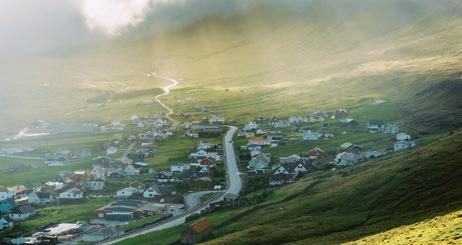
LEIRVÍK –NORÐRAGØTA
The route begins just above the football field in Leirvík. Excavation in Toftanes has revealed that settlements in Leirvík date back to around the year 800. Before cars and motorboats, the village path between Leirvík and Norðragøta was one of the main routes between the Northern Isles and the rest of the country.
Follow the cairns up towards Leirvíksfjall
From the top, there are excellent views across Leirvík, Gøtuvík, Mjóvanes and out to sea. The experience is enhanced when you use the binoculars that have been set up there. The northern islands of Kalsoy and Kunoy also come into sight, and on Borðoy, at the base of the mountains Klakkur and Hálgafelli is Fagralíð, where the first Faroese folk high school was built, and Símun av Skarði wrote the national anthem „Tú alfagra land mítt“ (Thou fairest land of mine).
The way down to Norðragøta might look steep from above, but the path is easy to see and good to walk. Steps are laid in places but be careful in slippery conditions. Beneath the crags, the cairns and posts will guide you down towards Norðragøta.
Looking at Gøta from here, you can understand why every summer crowds rush to the G! Festival to enjoy music in this beautiful setting. Norðragøta is also among the oldest Faroese villages.
The village path ends in the old district of Blásastova, a well-preserved farmhouse from around 1835 right next to the old wooden church from 1833.
Scan for more information about the hike & to see the digitial interactive map
20 LEIRVÍK – NORÐRAGØTA
Toftanes
3
Fagralíð
Leirvík
TRAIL DIFFICULTY Difficult
2 1 km (one way)
1 5 hrs (one way)
21 HIKING IN THE FAROE ISLANDS
Syðrugøta Gøtugjógv
Leirvíksfjall
Norðragøta
3.0 Di cult
Photos are marked where they were taken
4
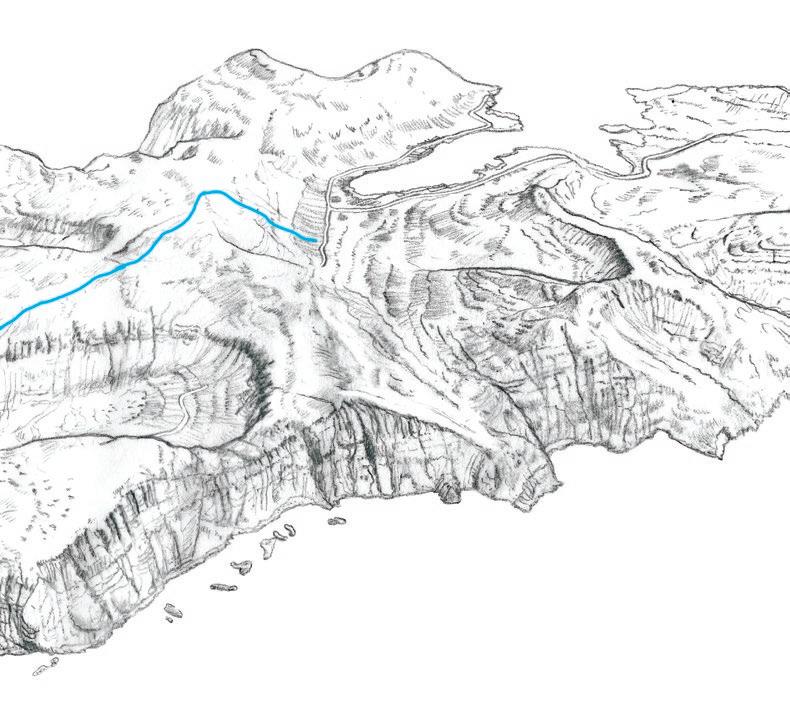
FUGLAFJØRÐUR –HELLURNAR
The path from Fuglafjørður to Hellurnar is called Sjúrðargøta (meaning the path of Sjúrður). Legend has it that a giant from Suðuroy came to Eysturoy to test his strength. No one dared to fight him except for a young man named Sjúrður who wrestled and beat the giant.
At the top of the pass, Skarðið, you will find two large cairns. In the old days, it was customary to put a stone on the cairn to maintain it, while saying ‘In the name of the Father, and of the Son, and of the Holy Spirit,’ to protect the travellers and ensure their safe return.
The hills Hulduheyggjar are to the west as you descend from the pass. Here, the story goes, the midwife of Dalbø in Fuglafjørður aided a Huldufólk woman (a type of hidden people) in childbirth, a service for which she was richly rewarded.
Approaching Hellurnar, the path takes you down through the crag Kliv. From here, continue down the hill. It is quite steep until you reach the out-field gate. It is possible to extend this hike and visit other villages by following the old village paths from Hellurnar to Oyndarfjørður and onward to Elduvík.
Take a detour from Skarðið to Altarið (the Altar), a rock formation on the top of Rustakambur. From here there is a great view of the islands and the sea to the north. This detour will add about 40 minutes to your hike.
Scan for more information about the hike & to see the digitial interactive map
Oyndarfjørður
22 FUGLAFJØRÐUR – HELLURNAR
Altarið
Skarðið
Fuglafjørður
2.0 Moderate
TRAIL DIFFICULTY Medium
3 1 km (one way)
1 5 hrs (one way)
Photos are marked where they were taken
Hulduheyggjar
23 HIKING IN THE FAROE ISLANDS
Hellurnar Kliv
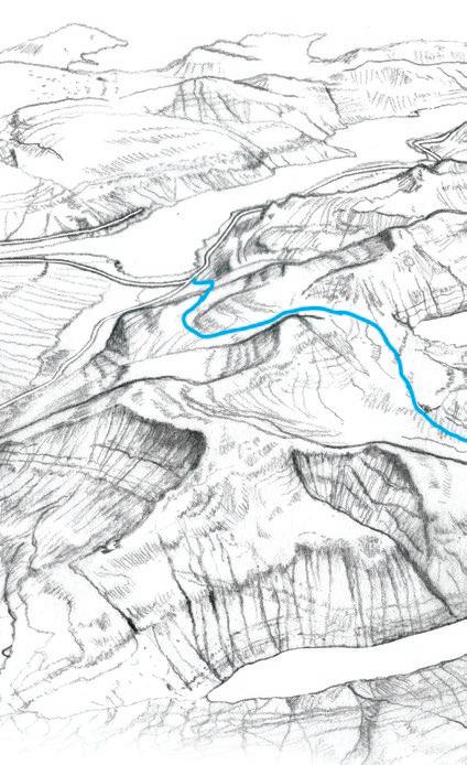
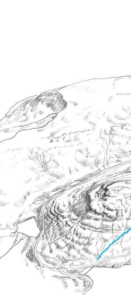
ELDUVÍK –OYNDARFJØRÐUR
The path between Elduvík and Oyndarfjørður is beautiful and filled with stories. The terrain in Elduvíkslíð is rather steep, but the path is good. Further on, you have a view of the small village of Funningur that lies wedged between the high mountains on the other side of the fjord. One of them is Slættaratindur, which - with its 880 metres - is the highest mountain in the Faroe Islands.
Before the church in Elduvík was built in 1952, the custom was that the youngest of the male godparents ran from Oyndafjørður home to Elduvík with the child after it had been baptized – and so, it was believed, the child would grow up to be fast and have great stamina.
There are ample opportunities to take a break on the hike, for example by the spring Keldan Vígda, which you reach when entering the pass at the top of the hill. In ages past, people were stationed here, at the old watch post, on the lookout for pirates.
The view from here is expansive down the rocky slopes out toward the island of Kalsoy and its high peaks, to the hill of Funningur, the rocks of Kolbanagjógv and the spit of Fjalltangi.
Follow the path until you reach the outfield gate and remember to close it on your way to the small village of Oyndarfjørður.
Scan for more information about the hike & to see the digitial interactive map
24 ELDUVÍK – OYNDARFJØRÐUR
Oyndarfjørður
Keldan Vígda
5
Elduvíkslíð
25 HIKING IN THE FAROE ISLANDS Elduvík Hellurnar 3.0 Di cult TRAIL DIFFICULTY Difficult 3 3 km (one way)
hr (one
1
way)
Photos
are marked where they were taken
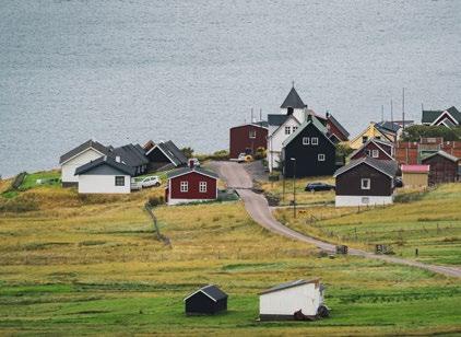
SKÁLAFJØRÐUR –OYRI
The often-underestimated village path between Skálafjørður and Oyri is fascinating and peaceful as well as pleasant to walk. As you meander through rough rocky areas and Eysturoyarsillin, a magnificent sill, you will find ball-shaped rocks and views over the many peaks of Eysturoy and Streymoy.
At Skálafjørður, the path is easy to find. From the sheep pen north of the church Keldan, cross the wide bridge over the river, where signposts with yellow marks will lead you onward.
When you have reached an elevation of 350 metres above the village of Skálafjørður, follow the old cairns that clearly indicate the right path all the way to Oyri.
If starting in Oyri, walk up to the first bend in the road Tungugøta. From here, follow the river just above the bend up through the gate, where you see the first signposts. You will also spot the first cairn at the gate in Oyri and signposts will lead you up to it. The path is difficult to spot, so you need to follow the signposts and the cairns all the way.
26 SKÁLAFJØRÐUR – OYRI
6 Scan for more information about the hike & to see the digitial interactive map
Skálafjørður
27 HIKING IN THE FAROE ISLANDS
Oyrarbakki Oyri TRAIL DIFFICULTY Medium 7 8 km (one way) 3 hrs (one way) 2.0 Moderate
Við Áir
Photos
are marked where they were taken
SAKSUN –TJØRNUVÍK
A wonderful path between perhaps two of the most beautiful and distinct villages in the Faroe Islands. The route starts below Dúvugarðar, located on the north-easterly side of the great gorge in Saksun. Dúvugarðar is a several hundred-years-old farmhouse, which now functions as a museum. The tall mountains give the area around Saksun an air of mystery and beauty. The fjord used to be a good natural harbour, but after a heavy storm in the 1600s, the fjord was blocked with sand.
On the way up to the cairn, the path may be indistinguishable in some places, but when you reach the cairn itself, there is a cairn path all the way to Tjørnuvík
As you arriva at Tjørnuvíksskarð enjoy the view of the characteristic rock pillars, Risian og kellingin (the Giant and the Witch). The story of these two is that they were sent to the Faroe Islands to drag the islands to Iceland. The preparations took longer than expected, and as the two were about to go back home to Iceland, the sun rose and turned the pair to stone.
Follow the cairns all the way down to Tjørnuvík. The densely build village is known for its special hymn singing, the Kingo-songs, which is an ancient hymn tradition that originates from the Danish hymn writer Thomas Kingo. The village has a choir that performs Kingo hymns. Tjørnuvík also has a nice sandy beach and striking waves that attract many visitors.
Scan for more information about the hike & to see the digitial interactive map
28 SAKSUN – TJØRNUVÍK
Saksun
7

29 HIKING IN THE FAROE ISLANDS Tjørnuvik Tjørnuvíksskarð 2.0 Moderate TRAIL DIFFICULTY Medium 6 4 km (one way) 2 hrs (one way)
are marked where they were taken
Photos
8
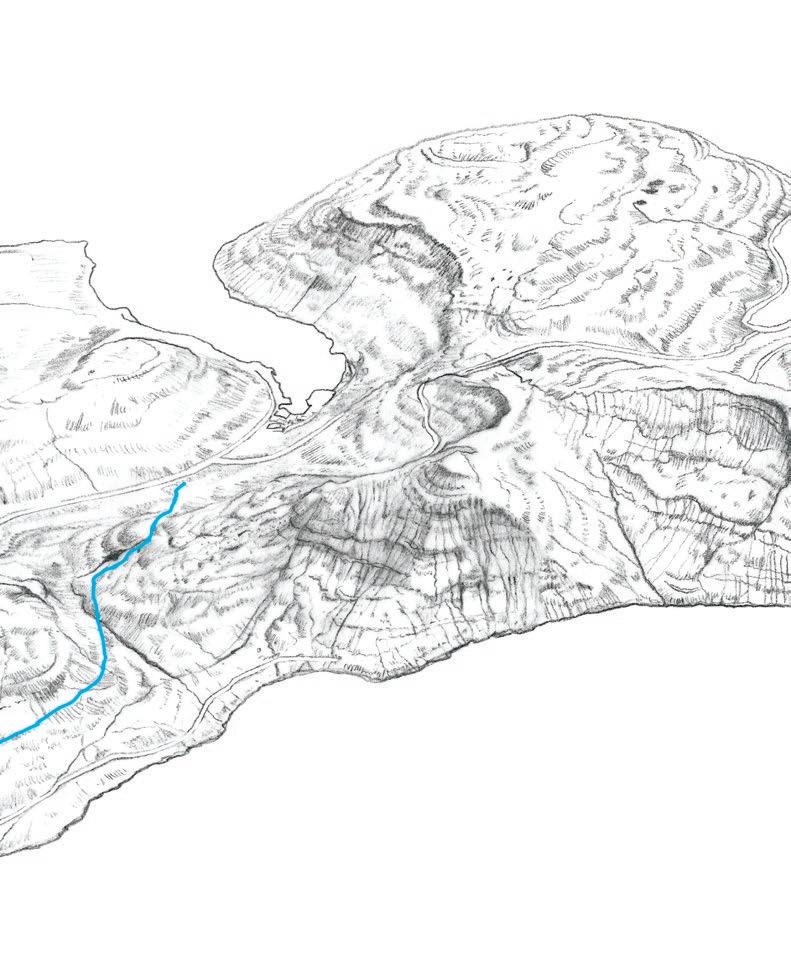
HVALVÍK –VESTMANNA
A meandering path reaching far inland and the largest water reservoirs in the country.
Walk along the river from Hvalvík and you’ll find cairns leading the way. There is a fine view over Saksunardalur, the longest valley in the country. From here, follow the electricity line all the way to Vestmanna. Now, you arrive at a cairn, stacked on a large stone called Kellingarsteinur. At the next cairn, after Kellingarsteinur, the path divides. The path south goes to the village of Kvívík and the path west goes to Vestmanna. Follow the latter.
On top of Hvalvíksskarð, you see over to Mýrarnar and one of the first hydroelectric dams built in the early 1960s. There is also a small private windmill park. The cairns and the power lines take you onwards, but be careful when the path turns south, as it is steep downwards.
There are now two possible ways down to Vestmanna. The path divides by the dam at Fossá. You can follow the road and enter Vestmanna in the east or go over the first dam, follow the cairns to Vestmanna along Gjógvará and down along Miðalsbrekka, the northern most part of the village.
Before the Faroe Islands got its first subsea tunnel between Streymoy and Vágar in 2002, the ferry port of Vestmanna was the hub for traffic to and from the airport in Vágar. Today the port is used for sightseeing trips to the stunning Vestmannacliffs and hosts a Saga Museum.
Scan for more information about the hike & to see the digitial interactive map
30 HVALVÍK – VESTMANNA
Hvalvíksskarð
Hvalvík
2.0 Moderate
Mýrarnar
TRAIL DIFFICULTY Medium
9 3 km (one way)
2 5 hrs (one way)
marked where they were taken
31 HIKING IN THE FAROE ISLANDS
Vestmanna
Photos are
TÓRSHAVN –KIRKJUBØUR
A hike characterised by the historic site of Reynsmúlalág and views over the islands of Hestur and Koltur. The path extends from the old Landavegur road in Tórshavn. From there, follow the path down to the river Sandá and then up to the hill. Remember to turn around when you hike uphill for the view over Tórshavn and Nólsoy. When you continue, go around the crag and continue to Reynsmúlalág.
Here you’ll find a podium built of rocks, a remain from the openair folk meetings that were held from the 19th century up to the 1960s as a part of the Faroese national movement. The tradition of having folk meetings is still alive in the Faroe Islands.
After Reynsmúlalág, the path continues southwards. Enjoy the great views over the islands of Sandoy, Hestur, Koltur, and Vágar.
As you approach Kirkjubøur, you will see a small islet, Kirkjubøhólmur, which used to be part of the mainland and the village. You can still see the ruins of old houses on the islet.
Kirkjubøur, which used to be the spiritual and cultural center of the Faroe Islands, is a beautiful and charming village, where most of the houses are built in the old style. The village has a wealth of attractions such as Kirkjubømúrurin (the ruins of an old cathedral believed to have been built around AD 1300), Stokkastovurnar (the old farmhouses from about AD 1350, built on the ruins of the old bishop’s seat), and Kirkjubøur Church, which is the oldest church in the Faroe Islands still in use.
Scan for more information about the hike & to see the digitial interactive map
32 TÓRSHAVN – KIRKJUBØUR
Koltur
9
Norðradalsskarð
Hestur
2.0 Moderate
TRAIL DIFFICULTY Medium
5 5 km (one way)
1h 20m (one way)
33 HIKING IN THE FAROE ISLANDS
Tórshavn Velbastaður Reynsmúlalág
Nólsoy Kirkjubøur
Photos are marked where they were taken
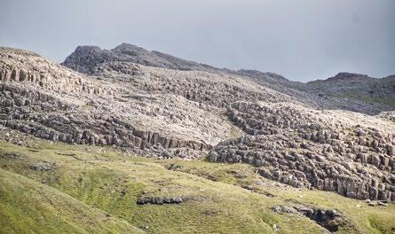
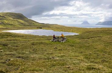
LEYNAR –KOLLAFJØRÐUR
Travel back millions of years on this route past tall cliffs and magnificent columnar basalt.
Walking towards Leynar is particularly beautiful and far easier as you begin at a relatively high altitude. The path is welltraversed, also on horseback, as is seen in the many hoof marks on the path. The walk through the valley and up the hill is tranquil and beautiful. Coming up you will see the cliff Líraberg and the columnar basalt at Stórareyni. You can also see the geological formation Streymoyarsyllin (The Streymoy Sill) and often Fulmars on the mountain cliffs. South of you is Skælingsfjall. It was first thought that it was the highest mountain in the Faroes, but when the height was measured with modern gauge equipment, it showed the mountain to be 100 metres lower than the highest. It is customary to climb Skælingsfjall on Jóansøkukvøld (Midsummer Night) to see the sunset and then the sunrise a few hours later.
The starting point of the village path is not well marked at either end, but many well-maintained cairns lead you along the way.
34 LEYNAR – KOLLAFJØRÐUR
10 Scan for more information about the hike & to see the digitial interactive map
Leynar
Oyrareingir
Skælingsfjall
2.0
Moderate
TRAIL DIFFICULTY Medium
4 9 km (one way)
1h 45m (one way)
Photos are marked where they were taken
Líraberg
Stórareyni
Skælingur
35 HIKING IN THE FAROE ISLANDS
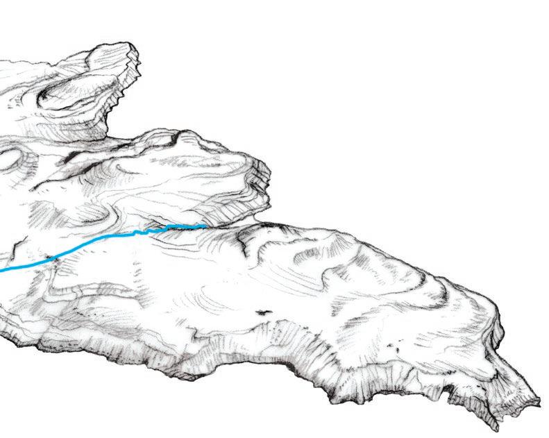
SKÆLINGUR –NORÐRADALUR
A scenic hike that passes through the unique rock formations of Gjáarbotnur.
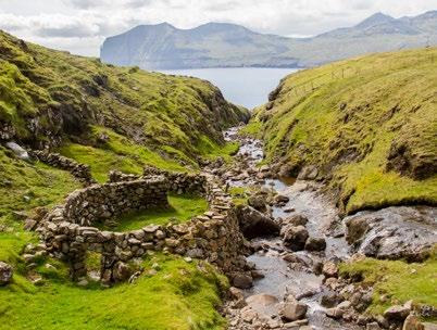
From the small village of Skælingur, go south from the main road on the unpaved road running through cultivated fields and continue through the gate that leads you to the beginning of the path. The innermost part of Gjáarbotnur is very pleasant, where the old sheep pen in the gorge makes the hike unique. The pen, which has recently been renovated by a stonemason, was first built sometime in the 19th century. The path can be taken in either direction, weather and/or mode of transportation deciding which direction is preferable. Whichever direction you take, there are some tough hills to walk up through.
Take the GPX-file with you. Cairns and paths are not always visible.

36 SKÆLINGUR – NORÐRADALUR
Skælingsfjall
Gjáarbotnur
11
for more information about the hike & to see the digitial
Skælingur
Scan
interactive map
Kollafjørður
37 HIKING IN THE FAROE ISLANDS Norðradalur 3.0 Di cult TRAIL DIFFICULTY Challenging 8 5 km (one way) 2h 45m (one way)
Photos are marked where they were taken
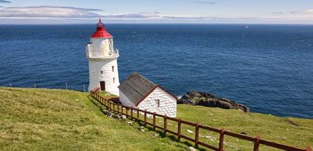
NÓLSOY –BORÐAN
Follow the path across the narrow island of Nólsoy to the lighthouse. The route starts at the path that runs southwards from Nólsoy village. Just inside the outfield fence, you reach Korndalur, with many ruins from the old days. These are called „Prinsessutoftir“ (ruins of the princess”).
Legend tells about a Scottish King’s daughter who had a falling out with her father because he would not acknowledge the man she wanted to marry and whose child she was carrying. They fled, arrived at Nólsoy and settled there.
Follow this trail to the old reservoir. Here, the cairns begin and soon you will walk up the slope west of the island. On the hike uphill, there is a site called Uppi í Skipi, where people hid from pirates in the old days. Near the top, you come to Hvíliplássið. It is customary to rest here, and the view is outstanding.
Then there’s a long stretch, Langabrekka, where you follow the path straight ahead. Here, the terrain can be quite wet in places. There are cairns all the way to the southern tip, but some of them are small and can be difficult to spot. Use the two masts that stick up where the lighthouse stands as landmarks.
The lighthouse, Nólsoyar Viti, was built in 1893. Back then, the lens was one of the largest in the world of its kind. It is 2.82 metres high and weighs about four tons. Both the lighthouse and the related houses are of superior workmanship, stacked from carved rocks.
Scan for more information about the hike & to see the digitial interactive map
38 NÓLSOY – BORÐAN
Nólsoy
12
Korndalur
2.0 Moderate
Hvíliplássið
Langabrekka
Borðan
TRAIL DIFFICULTY Medium
6 km (round trip)
5 hrs (round trip)
39 HIKING IN THE FAROE ISLANDS
Photos are marked where they were taken
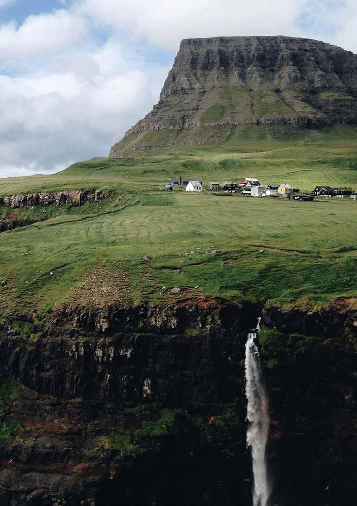
BØUR –GÁSADALUR
Hike along the old village path to the village of Gásadalur, which was one of the most isolated villages in the Faroe Islands until the tunnel officially opened in 2006.
The route starts in the valley west of the village of Bøur, about one kilometre south (or left) of the tunnel entrance. It is difficult to get to the village by sea and it was not until 2004 that the village was connected to the rest of the island by road when the tunnel was built. The helicopter service began in1983, but for the most part, the people of Gásadalur had to walk this path for connecting with the outside world. The first stretch of the path is steep and runs close to the edge of the mountain. Therefore, walk carefully.
There is no church in Gásadalur, so the school is used for services. The cemetery is from 1873. Before then, people were buried in Bøur and so the coffin had to be carried over the mountain to Bøur from Gásadalur. Bearers would rest at the Líksteinurin (Corpse Stone), which you will come upon halfway through the route.
From Skarði, the path twists down the mountainside to the village. Beware of loose stones. The small village is surrounded by a green infield with harsh high mountains. One of them is Árnafjall, which, with its 722 metres, is the tallest mountain on Vágar.
40 BØUR – GÁSADALUR
Árnafjall 13 Scan for more information about the hike & to see the digitial interactive map
Mulafossur Waterfall
3.0 Di cult
TRAIL DIFFICULTY Difficult
2 8 km (one way)
1 hr (one way)
41 HIKING IN THE FAROE ISLANDS
Líksteinurin Skarði Gásadalur
Photos are marked where they were taken
VATNSOYRAR –MIÐVÁGUR
The hike begins in Vatnsoyrar at the northern end of the largest lake. A few meters from the gate to the outfield, you will come across some building remains constructed by the British during World War II. During the war, the British built the airport and made significant improvements to the road network on the island. There are many interesting artefacts and pictures from the wartime period on display in the War Museum.
As you get closer to Miðvágur, you will see Trælanípan. To the south are the islands Koltur, Hestur, Sandoy and a part of Streymoy.

For the entire trip, you follow along the largest lake of the Faroes. The lake goes by many names – Leitisvatn, Sørvágsvatn, or simply Vatnið (the lake). Next to Trælanípan is the popular tourist destination, úti í Oyrum, where the lake flows into the ocean by Bøsdalafossur waterfall
You will now approach Miðvágur, home to many famous writers and poets. Down on the plain is the house of Beiti where Mikkjal á Ryggi (1879–1956) grew up, and just next to the road is a statue of him. Known for writing psalms and publishing several schoolbooks, he was also politically active. The river Hýsisá is living proof of the poet. One day when haymaking in 1909, Mikkjal inscribed two verses in the bedrock of Hýsisá, and they are still visible
Scan for more information about the hike & to see the digitial interactive map
42 VATNSOYRAR – MIÐVÁGUR
14
War Museum Vantsoyrar
4 1 km (one way) 1 hr (one way)
Trøllkonufingur
The poem at Hýsisá Water overcomes the bedrock, mountains have to fall. The scythe moves on, the grass is gone, the time will take us all.
If blood stiffens, the heart stops beating, and Man should pass away, the soul up in God’s heaven bright, lives rich and free each day.
Bøsdalafossur Waterfall
43 HIKING IN THE FAROE ISLANDS
Sandavágur
Miðvágur
Trælanípan
Hýsisá TRAIL DIFFICULTY Medium
2.0 Moderate
Vatnið
Photos are marked where they were taken
15
SANDAVÁGUR –SLÆTTANES –GÁSADALUR
This epic hike should be reserved for days with great weather conditions and fit hikers.
The route starts near Sandavágur. Walk diagonally toward the gorge Ravnagjógv and follow the path uphill.
After one to two kilometres, the terrain evens out, and you have a good view over a large part of Streymoy. There are a few houses in Slættanes, but they are usually empty because the village is uninhabited. The settlement has only been inhabited for a period of around one hundred years. A family moved to Slættanes in 1835 and spent the first five years alone in this desolate place. Others then arrived, and in 1940, 75 people lived in Slættanes.
Sometimes there were even more people. In 1964, the last inhabitants of the village left.
From Slættanes you move up to Skoradalshálsur where you’ll see stunning views of the north of Streymoy, including the famous Vestmanna bird cliffs. Continue down to Fjallavatn, the second-largest lake in the Faroe Islands. It can be difficult to cross the river without getting your feet wet but try to find a place where the river runs slower. Follow the path diagonally uphill towards the mountain wall. It can be a little confusing here because it can look like there are several paths. Beware of slippery rocks in some places on the way up. The path tops at approximately 595-meter altitude, and further to Bustardal you have a clear view of Árnafjall, which is the highest mountain in Vagar and Gásadalur probably the most photographed village in the country.
Scan for more information about the hike & to see the digitial interactive map
44 SANDAVÁGUR – SLÆTTANES – GÁSADALUR
Gásadalur
Bustardal
Bøur
4.0
Very Di cult
Slættanes
Skoradalshálsur
Fjallavatn
TRAIL DIFFICULTY Expert
25 2 km (one way)
7 hrs (one way)
Sørvágur
Photos are marked where they were taken
Ravnagjógv
Vágar Airport
Vatnið
Miðvágur
Sandavágur
45 HIKING IN THE FAROE ISLANDS
SANDUR –SØLTUVÍK
The route starts at the old school in Sandur. The latest archaeological excavations show that people have lived in the village as early as the years 300-400.
On the right-hand side of the road, after about 700 metres, you will see Gívrinarspor (The Witch’s Footprint) visible in the stone. At Gróthúsvatn, there is a four-metre-tall stone that the people of Sandur have decorated with a knitted cover, which is based on the legendary witch.
Enjoy the view over the peaceful lake Gróthúsvatn. It’s serene nature is in stark contrast to the winter waves, which can be quite rough in this area. From here the path winds uphill, and after approximately one kilometre you must be careful as the terrain on the road’s left-hand side is steep. After a while, it evens out again, and the terrain becomes flat all the way south to the mountain Salthøvdi. After about four kilometres, west of the Tyrilsválur hill, we have a good view down over the peat fields, where we very clearly can see the squared cuts, so-called peat eyes. At this point there is a side road that goes in a south-westerly direction to a lookout post just south of Søltuvík. From the lookout, you can enjoy the beautiful view over the steep cliffs on the western side of Sandoy, where you can, among other things, can see the 182 m high sea stack Oknadalsdrangur.
In November 1895, a shipwreck took place in the area. A British steamer, Principia, got caught in a storm and drifted into the rocky area. The ship sank and 28 people drowned. Only one person survived the tragedy. He managed to pull himself up on a cargo hatch and drifted at sea for 14 hours until he was rescued in Kirkjubøur. That same hatch is today used as a tabletop in Roykstovan on the old farm in Kirkjubøur. When you follow the road down to the beach, you can see two anchors from Principia that divers retrieved from the ocean floor in 2001. At the site, there is also a memorial stone in memory of the dead Scan for more information about the hike & to see the digitial interactive map
46 SANDUR – SØLTUVÍK
16
Oknadalsdrangur
47 HIKING IN THE FAROE ISLANDS Søltuvík Sandur Tyrilsválur Gróthúsvatn
1.0 Easy TRAIL DIFFICULTY Easy 5 4 km (one way) 1h 10m (one way)
Salthøvdi
Photos are marked where they were taken
17
GUÐRUNARLØKUR –SKARVANES –DALUR
The route begins by the sheepfold about 200 meters from the crossroads of Skálavik/Húsavík. This is where the small stream Guðrunarløkur runs, named after an excessively affluent woman living around the year 1400. Along the route, you will arrive at Klovnasteinur – two stones that look like one stone cleaved in two. An old superstition says that if you walk between them, you will die before the end of the year.
Somewhat south of Líðarrøkur, you get a beautiful view of Dúniavatn with Stóra Dímun, Lítla Dímun and Suðuroy in the background.
When you arrive at lake Dúniavatn, the downhill path will take you towards Skarvanes. It can be difficult to spot the descending path. The path is just south of the southernmost peatshed ruin, near the rock face. At the fence, pass through the gate closest to the river, Matará, and follow the river down to the village. You can now continue along the cairn path from Skarvanes to Dalur, the southern-most village of Sandoy.
48 GUÐRUNARLØKUR – SKARVANES – DALUR
Dúniavatn
Skarvanes
Scan for more information about the hike & to see the digitial interactive map
Klovnasteinur
Líðarrøkur
7 5 km (one way)
2 5 h (one way)
Skarvanes was the birthplace of the Faroese art of painting. Díðrikur á Skarvanesi (1802–1865) is considered the first painter in the Faroe Islands. Born in Stóra Dímun, he later moved to Skarvanes. Díðrikur painted colourful images of birds such as pigeons. Only five of the paintings are preserved and can be viewed at the National Gallery of the Faroe Islands.
49 HIKING IN THE FAROE ISLANDS
Husavik Skálavík
Dalur
2.0 Moderate TRAIL DIFFICULTY Medium
Photos are marked where they were taken
HVALBA –TRONGISVÁGUR
The route begins at Fitjarnar, west of Nes. Follow the fence between the infield and outfield up onto the ledge, Lítli Hamar. On the ledge is an overgrown stone path. The path is called Prestgøta (Priest’s Path), presumably because it is so broad that there was no need for the priest to dismount his horse. The path continues up along the gorge, Káragjógv, where, according to legend, the priest Kári fell whilst travelling on horseback. In some places, it is rather steep, and there are loose stones, so be careful.
From the top of Káragjógv are numerous cairns and a flat gravel path all the way to Mannagjógv. On this route, you can see the valley Vatnsdal and the lake Vatnsdalsvatn. The lake has two islets that are home to many birds.
Typically, this hike is estimated to take two hours, but many examples are of much quicker trips across Hvalbiarfjall. Shortly after 1900, a man covered the distance in 45 minutes when he ran from Hvalba to the old Doctor’s house in Tvøroyri to fetch medicine for a sick child.

From Mannagjógv, there is a remarkable view of the entire fjord of Trongisvágsfjørður.
Trongisvágur is an old agricultural village, also known for coal mining. In the 18th century, Tvøroyri developed as a market town and the two villages merged. At the gorge Mannagjógv, the path splits in two – you can go both ways. The path on the right takes you to the grove in Trongisvágur, where you will find benches and tables and a great place to relax with a cup of coffee after the journey.
50 HVALBA – TRONGISVÁGUR
Nes
Hvalbiareiði
Hvalba
18
for
Káragjógv
Scan
more information about the hike & to see the digitial interactive map
5 5 km (one way)
2 hrs (one way)
For centuries, the path was the main connection to the northern villages of Suðuroy. The traffic across Káragjógv substantially decreased when the tunnel of Hvalba opened in 1963 as the first tunnel in the Faroe Islands. In 2021 it was replaced by a new tunnel. All sorts of things have been carried and dragged over this mountain. It is said that the first pipe organ of Hvalba was carried across the mountain in the early 1890s. The organ weighed about 200 pounds.
51 HIKING IN THE FAROE ISLANDS
Vatnsdal
Mannagjógv
Trongisvágur
Gluggarnir
DIFFICULTY
TRAIL
Difficult
3.0 Di cult
Photos are marked where they were taken
TVØROYRI –HVANNHAGI
Starting from the hospital in Tvøroyri, head to the road Ovari Vegur and continue in the direction of Trongisvágur. Once you have walked approximately one and a half kilometres, you arrive at the gate leading to the outfield.
Continue along the well-trodden path to the highest point and enjoy the view northeast of the islands of Lítla Dímun, Stóra Dímun and Sandoy.
From here head down towards the valley of Hvannhagi. The area is teeming with interesting geological phenomena including remains from a giant avalanche or rockslides that roared down into the valley several thousand years ago.
Follow the path, which slowly turns to the left into the valley. The beautiful, circular lake, surrounded by steep green mountainsides. No wonder Hvannhagi has been a popular destination for families and travellers for generations. The valley is also a popular area for sheep since parts of the area have been used as “fitilendi” (fat pastures).
When you’re ready to walk back home you can go the same way as you came, or you can go through Frostgjógv, which is a gorge further up in the southern part of the valley. Beware of loose rocks in the gorge, especially if you are travelling in a group. You then come to a sheepfold at the end of the gorge. Here, there is no visible path. But once you’ve gone a few metres from the sheepfold, you will spot the path from Tvøroyri where you walked up earlier.
Scan for more information about the hike & to see the digitial interactive map
52 TVØROYRI – HVANNHAGI
19
Hvannhagi
Frostgjógv
2.0
Moderate
TRAIL DIFFICULTY Medium
6 km (round trip)
2 hrs (round trip)
Photos are marked where they were taken
Froðba
Holið í Helli
53 HIKING IN THE FAROE ISLANDS
Tvøroyri
Krambatangi
FÁMJIN –VÁGUR
The cairn path begins on the mainroad just south of the village of Fámjin. Follow the cairns uphill.
After walking for about 45 minutes, the path becomes level. There is a short stretch by Eyðabakki, where there are steep slopes, so tread carefully, especially if you are travelling with children. Apart from here, it is entirely flat and easy to walk the rest of the way. You’ll pass lakes essential to the history of electricity in the Faroe Islands. The Botnur power plant became operational in 1921 and was the first hydroelectric power plant in the Faroes.
South of lake Ryskivatn you will find the spring, Biskupskelda. It is not known why the spring has been given this name. When the people of Vágur went to the outfield to drive sheep, they would always stop to drink at this spring, said to be good for your health.
As you approach Vágur, a great view of the fjord emerges. You can see Akrar, Rávan, Rútafelli and the vertical mountain cliffs Eggjarnar – a very popular tourist destination.
Vágur is the second-largest municipality on the island of Suðuroy, and people have lived here since around 1350–1400. In 1804, Nólsoyar Páll built the first Faroese ship, Royndin Fríða, in Vágur.
54 FÁMJIN – VÁGUR
20
Fámjin Kirkjuvatn
Scan for more information about the hike & to see the digitial interactive map
7 km (one way)
2,5 hrs (one way)
The church in Fámjin is from 1876, and in it hangs the first Faroese flag. The flag was drawn in 1919 by Jens Olivur Lisberg (1896–1920) along with Janus Øssursson and Pauli Dahl. Jens Olivur Lisberg died of the Spanish flu at a young age and is buried in Fámjin.
55 HIKING IN THE FAROE ISLANDS
Reyðibakki Ryskivatn Botnur
Vágur
TRAIL DIFFICULTY Medium
Moderate
Photos are marked where they were taken
2.0
LOCATIONS OF HIKING ROUTES IN THE FAROE ISLANDS