5 minute read
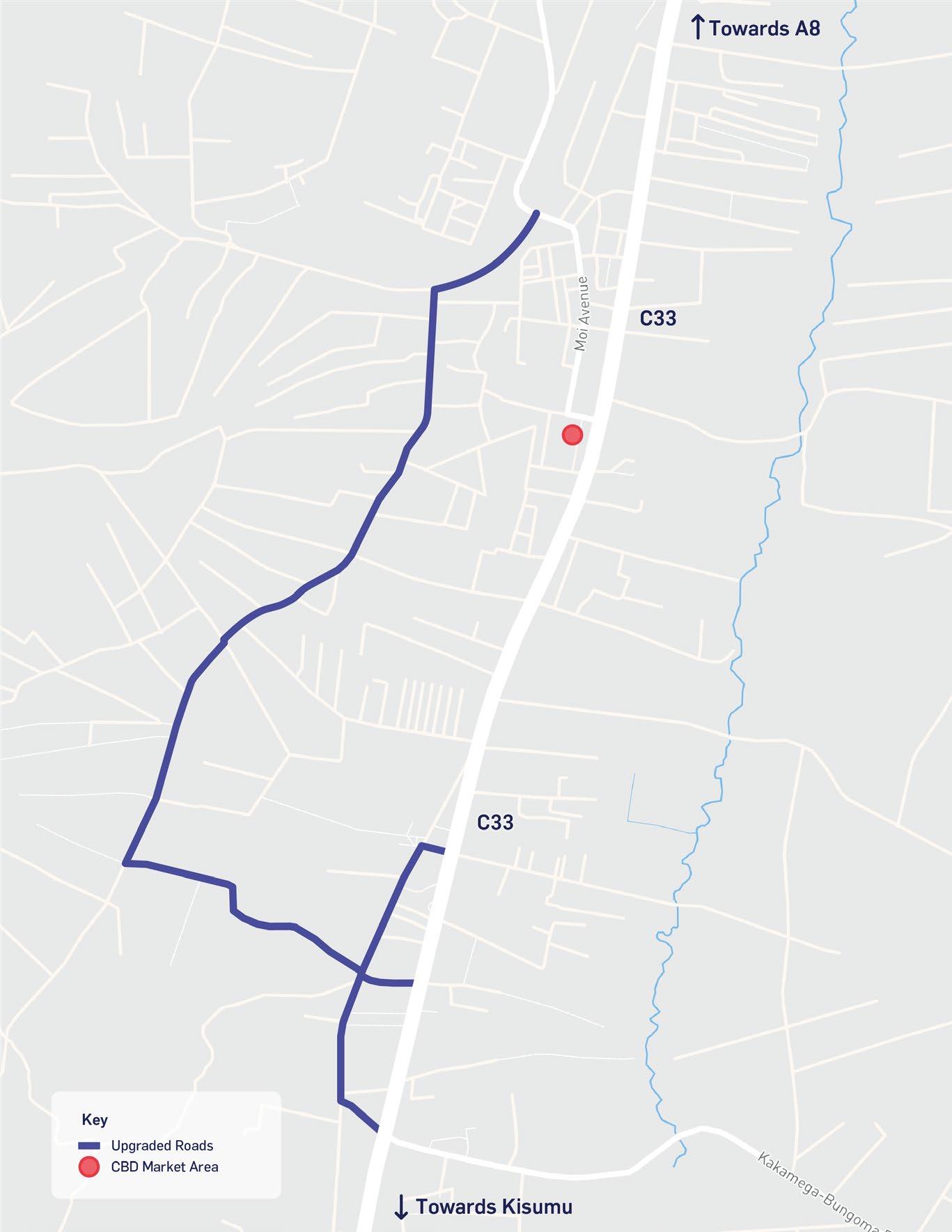
Figure 2-1 – Study area


2.1 Study Area
A number of areas across Bungoma County will take the geographic focus of the UEP, the main ones being Bungoma Municipality and Webuye town.
Bungoma County is located in western Kenya and measures approximately 3,032.4 km2 in area. The County borders Busia, Kakamega, and Trans-Nzoia counties as well as Uganda to the west, making it a strategic gateway to inner East Africa. The County is part of the Lake Region Economic Bloc (LREB). The County is comprised of nine sub-Counties namely; Kanduyi, Kabuchai, Sirisia, Kimilili, Webuye East, Webuye West, Tongaren, Bumula and Mt Elgon. The A8 road runs through the centre of the County and connects Uganda with West Kenya. Furthermore, the Uganda Kenya railway runs through the County and Bungoma Municipality, connecting Uganda to the seaport of Mombasa, located on the Indian Ocean.
Bungoma Municipality is the main urban growth centre located in the southwest of the County. It is the headquarters and administrative centre of Bungoma County. Bungoma Municipality’s boundaries are undergoing the process of expansion to cover a total land area of 207 km2 and include 15 sub-locations including Bungoma Township, Mateka, Namasand, Ngo’oli, West Nalondo, Namwacha, Muanda, Watoya, Kabul, Ndengelwa, Mayanja, West Sangaalo, Tuuti, South Kanduyi, and Khalaba. The plans to expand the Municipality boundary have been approved by the County Government and are awaiting to be gazetted by the National Government.
Webuye Town is another major urban growth centre located in the southeast of the County next to the River Nzoia and the boundary of Bungoma and Kakamega Counties. Webuye, being strategically located along the A8 northern corridor, which runs through the centre of the town, makes it the main industrial centre of Bungoma County; it is home to many light and heavy industries including the former Pan Paper Mill. It is important to note that there is a lack of planning documents and sectoral plans covering the new Municipality area, there are only documents at the County-level or related to the 2016 Bungoma Planning area. Therefore, the spatial analysis was limited to these geographical units due to the availability of information and data.
Figure 2-1 – Study area
Source: Atkins, 2022
2.2 Planning Context
The Planning Context sets the basis for the development of the UEP. The Diagnostic Report in Appendix A covers key international and national trends likely to influence the sustainable growth trajectory of Bungoma Municipality; national strategies and policies, and Bungoma Municipality’s own priorities and ambitions.
The Bungoma County Integrated Development Plan 2018-2022 (CIDP) is grounded in the Vision 2030, the MTP III, the NSP, international targets such as the Sustainable Development Goals. The CIDP is one of the most important documents at County level, which aims to coordinate development and allocate budgets. The strategic objectives of the CIDP are: i) to promote and enhance human capital development through education and training, ii) to promote economic development by sustaining a robust and vibrant economy, iii) to provide high-quality livelihoods and a sense of wellbeing for all, iv) to ensure environmental sustainability by ensuring there is minimal disruption to natural resources, habitats and loss of biodiversity, v) to optimise land use, vi) to co-operate and collaborate with other spheres of government, vii) to enhance public involvement in the processes of governance, and viii) to engage an entrepreneurial, innovative and competitive private sector that delivers economic growth and better jobs for the people of the County. The draft Bungoma County Spatial Plan 2016-2025 (CSP) is a long-term, GIS-based framework for organising and distributing local populations and activities in-line with both County and national objectives. The CSP also aims to co-ordinate the implementation of special projects and programmes with a focus of managing scarce resources and avoiding the duplication of planning efforts. The plan identifies the towns of Bungoma, Webuye and Kimilili as the main urban centres and its respective development plans should be aligned with the provisions in the CSP. Its vision for Bungoma County is: “To be a leading County that effectively manages and utilizes all its resources to generate wealth and sustainable development for prosperity”1 .
At the Municipality level there are three non-statutory documents driving its development. These include the draft Bungoma Municipality Integrated Development Plan 2018-2022, the Bungoma Municipality Strategic Plan 2020-2024 and the Bungoma Local Urban Development Plan 2016-2026.
The draft Bungoma Municipality Integrated Development Plan 2018-2022 (draft IDeP) provides a policy framework for the sustainable growth of the Municipality and is grounded on the Kenya Vision 2030, NSP, MTP III, and UN sustainable development goals. It is formed of a total of 12 strategic priorities with the overall aim to develop and regenerate places, support neighbourhoods, communities and centres to respond to economic change, encourage growth of the Central Business District (CBD) to support the economy and further growth of the township and surrounding areas. The draft IDeP also provides an implementation and delivery strategy for key projects across the Municipality over the next four years. The Bungoma Municipality Strategic Plan 2020-2024 (MSP) is a high-level strategic framework to aid in the implementation of the draft IDeP over the next four years. The MSP sets out five key strategic plans in order to further guide the development of the Municipality, these include: i) creating opportunities for growth, ii) increasing wellness, safety and tackling social ills, iii) building a quality living environment, iv) embedding good governance and vi) improving educational outcomes and opportunities for youth development. These strategies are aimed at further guiding the development of the Municipality over time and should be read in conjunction with the draft IDeP.
The Bungoma Local Urban Development Plan 2016-2026 (LUDP) was prepared by the Ministry of Lands and Physical Planning in collaboration with the County Government of Bungoma and a local planning consultancy, Two Ems. The LUDP is a guiding document for the coordination of development, infrastructure and public services over a ten-year period within a Bungoma Planning Area. Furthermore, it is used as a tool to control, guide and allocate land within the Municipality for public services and other land uses. The plan was developed for a Planning Area which extends beyond the current boundary of Bungoma Municipality, see section 2.1 for further details. The LUDP sets out a vision for Bungoma Municipality to become “A compact economic hub that is accessible, liveable, inclusive, competitive and environmentally sustainable”2 .
1 Bungoma County, CSP, (2018) 2 Bungoma Municipality, LUDP, (2016)