CYKELNERVEN 2023 ROADBOOK

WE CHALLENGE THE FRENCE ALPS - 6 - 11 JUNE
10 YEAR
ANNIVERSARY
- UNIQUE MS CHARITY EVENTFOUR DAYS OF CYCLING IN THE MOUNTAINS IN THE ‘WHEEL TRACKS’ OF THE PRO-RIDERS


LACETS
DE MONTVERNIER challenged by CYKELNERVEN riders in 2022
TABLE OF CONTENTS
- THE PROLOGUE
- ROADBOOK - YOUR GUIDE TO THE TRIP
- CYKELNERVEN - STAGE 1
- CYKELNERVEN - STAGE 2
- CYKELNERVEN - STAGE 3
- CYKELNERVEN - STAGE 4
- THE BONUS MOUNTAINS
- THE UNPREDICTABLE
- THE ENERGY PLAN
- ENERGY FROM PUREPOWER
- DEPARTURES & ARRIVALS
- DELIVERY OF THE 'RACE BAG'
- HOTELS
- COACHES
- THE ROUTES
- IS YOUR BIKE READY?
- MECHANICS
- THE CYKELNERVEN CLOTHES
- CONTACTS
- THANKS TO THE SPONSORS
MAY 2023 / BO VELDS ANDRESEN
WE CHALLENGE THE THE DECISIVE TOUR CLIMBS
FOUR DAYS OF CLIMBING, 6 - 11 JUNE
CYKELNERVEN - 10 YEAR ANNIVERSARY
THE PROLOGUE
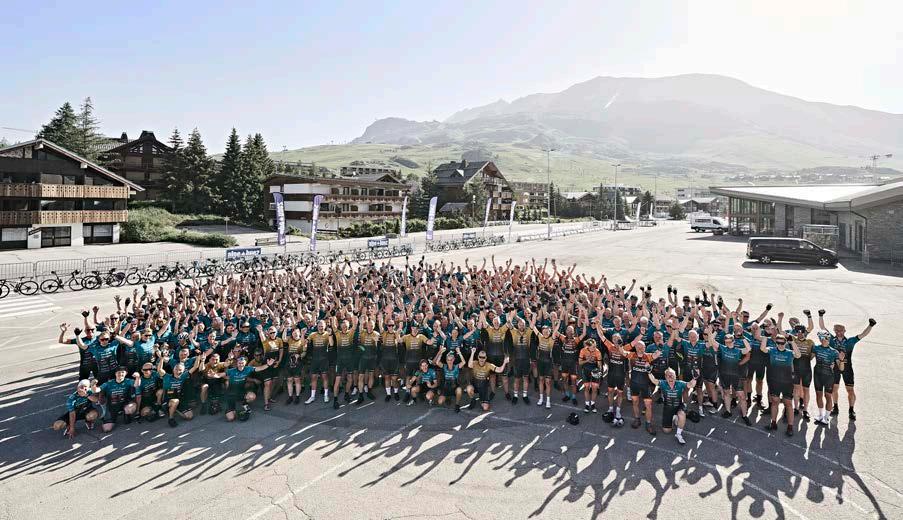
The anniversary year of Cykelnerven offers four unique and challenging stages in the French mountains. The event is fully tailored to more than 450 excited and well-prepared riders - we are looking forward to kicking it off. Welcome to both our Danish riders and the international MSIF riders.
Also this year, we are truly faithful to the concept of "The decisive mountains". There are relatively new mountains in terms of the Tour de France, but also some historic and familiar climbs waiting for you riders. The experience and the challenge will undoubtedly be great - so the entire team and organization behind Cykelnerven hope that your great commitment and your training preparation will greatly benefit you.
With all our cycling groups, we will fight through the challenges and try the same climbs as the professional riders. It is unique and exciting, but at the same time it requires endurance and both physical and mental strength. This is the game during the Tour de France's 21 exhausting stages, but also for Cykelnerven's challenging four-day charity event.
We have carefully reviewed the Tour de France stages for 2023, and expect that the challenging stages 14, 15 and 17 will be decisive for who wins the tour de france and can wear the yellow jersey. These three stages mean that Cykelnerven's route for 2023 goes through the Tour de France towns of Les Gets, Saint Gervais and on to Bourg Saint Maurice.
You will pedal your way through valleys, peaks and through the thin air on top of mountain peaks. All of you tough and well-prepared riders will ride through a real cycling expedition in the mountains, where we take on the rough terrain step by step.
We have to overcome, defeat and enjoy at least eight climbs - and up to 14 climbs depending on level, shape, strength and experience in the mountains. As something new this year, we have tried to adapt the stages to the diversity that Cykelnerven and

the event cater for. Not all riders have the same skills and experiences with riding in the mountains. Therefore, some routes will be differentiated with different kilometers and meters of elevation gain.

The quote "more is not necessarily better" has also been central to our thorough planning of the routes. Cykelnerven is not a cycling race, but rather a unique cycling experience together with good and committed teammates. It's not about getting to the finish line first, and you do not ride with a race number nor on closed roads.
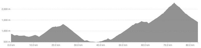
Overall, the four stages provide between 330 km and 391 km of cycling with no less than between 8,976 and 10,813 meters of elevation gain.
You will get to meet both other international riders as the MSIF will start with 25 riders - and you will meet more than 180 Danish riders. In addition, a strong 20-person staff team and 20 coaches will contribute to as smooth a process as possible over the two weeks.
We can plan and organize a lot of details, but we cannot predict weather, wind, will and the road to the summits on two wheels! We all have to live with that uncertainty and find solutions to it as in previous years.
For the best possible start to the cycling days in France, all riders will be welcomed at a joint meeting after arriving in Les Gets on Tuesday 6th June. The staff teams will explain all practicalities, the challenges and the necessary information so that you can focus on cycling, on achieving victories, making new friendships - and making a big difference for a world without Multiple Sclerosis. Although this RoadBook is primarily focused on cycling, the most important part of the event is fundraising.
We look forward to seeing many months of preparation and training, prove their worth in France.
“For a world without MS…!”
ROADBOOK - YOUR GUIDE
The purpose of this RoadBook is to prepare you in the best way towards the cycling challenges and describe the four unique days in France.
Stage descriptions will give you the opportunity to gain thorough insight into routes, climbs and practice for departure and arrival. In addition, we have made an overview of hotels, places to eat, driving in teams and in the different levels. It is an important supplement to your months-long training efforts since autumn 2022.
Since the start of the CYKELNERVEN 2023, we have repeated that the key word for good experiences is thorough preparation. Therefore, the detailed review of this year's selected routes and mountains should be motivating reading both before and during the stages in France.
The detailed descriptions of the difficulty of the stages, of the degrees of difficulty of the climbs and not least the ‘job for your legs’ will undoubtedly emphasize the fact that it requires great commitment and good endurance. We hope you are ready to take on the rough mountain sides and many hours in the saddle four days in a row.
The entire team behind this year's Cykelnerven has prepared thoroughly since late summer last year. We foresee some unforgettable days and we will do everything we can to give you riders the optimal setting so that you and all other riders an focus on cycling, on togetherness and on great victories in the fight against Multiple Sclerosis.
Remember that you will have the opportunity to pedal at the same pace and cadence as the pro riders - just one month before the Tour de France field is entering the scenery. The World Tour teams race against the clock and surely compete. Instead, we focus on togetherness, safe way of riding and our overall unique unity. We focus on helping and motivating each other - and we take our time to stretch our hands high in the air on each of the mountain peaks that we have to cross. We share the good experiences.
This CYKELNERVEN ROADBOOK 2023 aims to inform you and all the other excited riders for this year's cycling event organized by the Multiple Sclerosis Association and their close collaborative partners. The content is a summation of peptalks, briefings, our Facebook content and dialogues and mails distributed in recent months. Enjoy the reading…
CYKELNERVEN - STAGE 1

FINAL MOUNTAINS OF THE 14TH TDF-STAGE

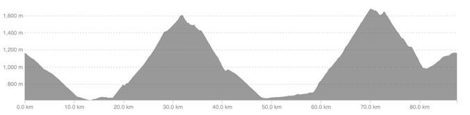
“The start of stage 1 begins with an 11 km descent from Les Gets towards the town of Taninges before the ascent of the first of two significant tour mountains begins. We have 87 km and 2,332 meters of elevation gain ahead of us - and the stage reflects this year's 14th Tour de France stage from kilometer 86.5 until the final town of Morzine at kilometer 152"
After arriving in Les Gets on Tuesday, a joint welcome, dinner and a good night's sleep, body and mind must be ready on Wednesday for the start of the unique cycling experience. The challenges of the decisive Tour de France mountains lie ahead.
We are settled in the mountains and therefore have to descend 11 km before the legs can warm up with 8 km of relatively flat from Taninges and before we reach Mieussy. It is from this small French town that we exactly follow the official tour route for the 14th stage of this year's Tour de France.
At the roundabout, we follow the sign for COL DE LA RAMAZ, which is the first exit on the right. Ahead of us is a 13.9 km climb with a 7.1% average gradient. It reflects 986 meters of altitude before we stand at the top at a height of 1,619 meters.
Col
(1,619 m) (13.9 km / 7.1%) Col
(1,691 m) (11.6 km / 8.5%)
Les Gets
de la Ramaz
de Joux Plane
Les Gets
The road up offers beautiful terrain with grasslands, cattle, small trees, and houses and we drive through the local communities of mountain farmers until approximately 5 km from the summit. After this, we wind along hillsides and rougher terrain - and with 3 km to the top we drive through a tunnel and on to the real skiing area. In a markedly different area, we can almost see all the way to the top and the percentages of climb are quite manageable at 4-6% until the last kilometer, when the steepness again peaks and you have to push harder in the pedals!
With the defeat of the first tour mountain of the year, a long descent awaits. After driving 9 km downhill, you drive directly onto the same road as today's first descent from Les Gets - so the following 6.5 km are recognizable.
On the first descent to Taninges we drove to the right - this time the route goes left in the town and towards Samoens to hit the foot of the COL DE JOUX PLANE. Before that, however, there will be lunch and the opportunity to fill up bottles at a depot by the parking lot in the middle of Taninges shortly after the river.
The ride 10 km west towards Samoens can be used to digest lunch, and the road rises slightly, which is a nice chance to warm up legs and body for another significant mountain challenge. Although COL DE JOUX PLANE is 2.3 km shorter than COL DE RAMAZ, it is considered to be a tougher mountain to conquer. The average rate of increase is 8.5%
COL DE JOUX PLANE has not been part of the Tour de France since 2016, which was also the year when CYKELNERVEN's riders were present at these mountain as the final challenge. Bad weather conditions made it both even more challenging, but also the descent became risky, which is why the climb was "neutralized" for our riders. That's why a revenge also awaits at this 10-year anniversary for riders who didn't make a mark in the personal mountain book next to an otherwise well-known tour mountain.
The approach is very two-part with a 7-9% gradient for the first 6 km. After that, you really have to push through as the following 5 km's climb varies between 9.1% and 10.5%. The mountain profile's black categorization reflects a tough final finish before you can click off the pedals at an altitude of 1,691 metres.
Just like the Tour de France route, we continue over the top and further down towards the well-known ski resort of Morzine. The Tour riders end their 14th stage in this town after 11 km of difficult descent. We take the
same trip, but continue all the way up to Les Gets, which means a 6 km controlled ride until we can park the bikes at the hotels and look back at the first stage of the event.
COL DE JOUX PLANE

“THE FINAL MAJOR CLIMB OF THE 2023 ETAPE DU TOUR. AND A TRULY EPIC CLIMB OF THE FRENCH ALPS”
At the Hotel Bellevue in Les Gets, there will be a great opportunity for socialisation, recovery and great stories about the experience of the 1st stage and the first two Tour de France mountains during this year's CYKELNERVEN.

Hôtel Bellevue: 125 route du Front de Neige, 74260 LES GETS
 The conquest of the Col de Joux Plane can be enjoyed with a beautiful view of both the top of Mont Blanc and the Lac de Joux
CYKELNERVEN - STAGE 2
FINISH AT THE TOP OF ‘LE BETTEX’
“Just like Tour de France stage 15, we start in the mountain town of Les Gets and finish our 2nd stage at the top of the Saint-Gervais Mont-Blanc Le Bettex climb. But specifically for this day, we offer three different distances for three different levels. Regardless of the distances, do not underestimate the harshness of the hilly mountain terrain".

Let's start by saying that the goal of CYKELNERVEN is to achieve great experiences with great challenges - of course with a focus on the important fundraising effort, and of course also when you struggle for many hours in the saddle four days in a row.
Not all riders have the same experience with challenging rides in the mountains. This is the main reason why we offer THREE LEVELS with THREE DIFFERENT LEVELS OF DIFFICULTY specifically for this stage
As in previous years, there will be assistance from the fantastic teams behind the event. This means that support cars, mechanics, transport of luggage in large trucks, photographers and other important functions will help and focus on creating an optimal event and experiences.
Our greatest hope is that all riders have prepared very well since the start of the journey in autumn 2022. This should mean that every rider is able to cycle each stage with the 'help' of endurance, strength and the necessary level of fitness. We do not do bike races or race against
time - we ride in teams and together, which mean that on flat road segments we keep up with the speed, and on climbs you ride according to your own abilities, after which the team's coaches wait for you at the top of the mountain.

occurs. These conditions and considerations are especially important during the long and challenging distance of the 2nd stage. Here, the riders are primarily assisted with lunch, water and nutrition at one selected location through one service car. The rest of the time, riders and coaches are self-supporting, i.e. we find water reservoir, but have the necessary energy with us along the way until the bike is parked in Saint Gervais. See the stage as a hard and extended long-distance training!
GROUP 1*
Departure 08:00
Distance: 130 km
Elev. gain: 3.302
GROUP 2
Departure 09:00
Distance: 99 km
Elev. gain: 2.149
GROUP 3
Departure 09:30
Distance: 69 km
Elev. gain: 1.365
*) Requires registration and dialogue with the sporting officials (Bo Velds Andresen / Benjamin Justesen
LE DÉFI CYCLISTE EXTRÊME
(THE MORE EXTREME CYCLING CHALLENGE)
The start of this stage goes on at 08:00 for the skilled and experienced riders, who want to ride the ‘Le défi cycliste extrême' stage and are fully aware of the prerequisites and requirements. The stage consists of the majority of the major challenges on the Tour de France's 15th stage. CYKELNERVEN's determined expedition is no less than 130 km with 3,202 meters of elevation gain.

The challenge naturally requires a great portion of experience, a really good physique and solid endurance. It also requires that this stage can be driven at a steady and constant speed on climbs and a secure good flow on descents. It will mean that we arrive in Saint-Gervais in reasonable time to be able to conquer the final climb 'LE BETTEX MONT BLANC’.

The jagged stage le picture shows the four hard climbs to be challenged. The stage starts from Les Gets and with the descent to Taninges.
rst warm-up CHÂTILLON
), which comes after 12 km of
You should use this as a good warm-up ride rst mountain
Col de la Colombière
Gets
Col de la Croix Fry Col des Aravis Le Bettex
Les
Col de la Colombière
Col de la Croix Fry
Col des Aravis Le Bettex
COL DE LA COLOMBIERE which is not included in this year's tour, but which is a mammoth of 17.3 km with an average 6.5% of increase. From the start in Scionzier and via Marnaz, the climb offers riders a climb of 1,127 meters up to a height of 1,618 meters. The first half is the least tough - and after 10 km the climb changes character. The percentages here are between 8-11% for the last 7 km and just before the top is reached, you should push through a section with 10.6% challenging increase.

 COL DE LA COLOMBIERE
Once we have crossed the DE LA COLOMBÍERE
23 km descent towards Thónes. This is where we again encounter the 15th Tour de France stage.
After a few kilometers of we drive directly up towards the town of Manigod and further towards the top of the LA CROIX FRY of 11.3 km increase of
With two big tour climbs behind us the expedition continues with a descent until we turn right and up towards the which is a summit at
Following the 12.2 km descent towards Flumet riders can look back at two significant mountains that have most likely left traces of exhaustion! Butthere must be energy for the ride through the valley to Megéve, and on towards the last summit -

The distance from Flumet to the start of the climb is 18.7 km and with 212 meters of elevation gain. Le Bettex itself is a 7.2 km ride up through small French winding country roads. The profile shows an average increase of
 SAINT-GERVAIS MONT-BLANC LE BETTEX.
SAINT-GERVAIS MONT-BLANC

The town of Saint-Gervais Mont-Blanc has been part of the Tour de France four times before, so a relatively new town in tour-cycling history. The city has approx. 5,800 inhabitants and is known for both the skiing area Le Bettex, but also other activities such as mountain running and hiking, mountain biking, bathing in the melt water from Mont Blanc and in the healing thermal baths.
When the entire CYKELNERVENS caravan arrives in this French city, we get an advance on the joy of the tour, as the city is both the final city of the Tour de France's 15th stage. It is also a central base for the interesting 16th Time Trial stage - and at the same time is the starting city for 17th stage. A stage that our riders enjoy over two days instead of the rush of the tour riders in just one day!

MIDDLE DISTANCE - WITH BONUS CLIMB
The start of the 2nd stage, the 'Middle distance’ is at 09:00. It is suited for riders on ‘Group 2’ level and the distance of the stage is 99 km - it offers 2,149 meters of elevation gain.


Instead of repeating the descent from Les Gets directly towards Taninges as in stage one, the route goes in the opposite direction and 6 km down to Morzine and then 10.3 km up towards the COL DE JOUX PLANE from the back side. You therefore get pleasure from driving the final descent of the first stage as an ascent! That is, a enjoyable “wake up” climb of 692 meters of elevation gain reflecting an average increase of 6.7%
Just like the route for “Le défi cycliste extrême”, we are driving in the direction of Taninges which after the descent from Joux Plane (11.5 km) to Samoëns is an 11 km slightly downhill stretch. Let your legs have a welldeserved break and enjoy a rare moment without going steeply up or down.
From Taninges we drive to Châtillon (2.55 km / 4%) which takes us in the direction of Cluses. As we generally try to replace larger and busy roads with more scenic mountain sides and good altitude meters, we drive off the 3rd road in the roundabout approx. 43.8 km out on the route - aim for 'Boulangerie Tiffany', which in case of emergency can be a coffee stop or an excuse for a French chocolate croissant.
From here it goes 6 km upwards towards Saint Sigismond and on towards La Frasse on a relatively flat plateau. From the town of Aráchesla-Frasse we drive back down towards the valley via a winding road through the forest. Be aware of the speed, especially in the hairpin turns. After driving through the small town of Balme, we are in the valley and will come out at the roundabout to the main road "Rue Nationale" near Magland (see the map).
Altid den største støtte på toppen
Les Gets Col de Joux Plane (10.3 km / 6.7%)
Chatillon to Araches (7.8 km / 2.8%) Le Bettex (7.2 km / 7.7%)
We drive approximately 500 meters ahead, safely cross the main road and the river, after which we drive 5 km on the opposite mountain side and on smaller cycle paths. When we have driven a total of 72 km, we arrive in the town of Sallanches, where we calmly move through the idyllic French atmosphere and the one-way streets. We set our sights on the country road 'Route du Fayet' and towards the Grand Final which starts 2 km after Domancy and at the 78 km mark.
At the town of Vertex, we turn into the 'Route de Lardin' and keep our tight pedalling all the way until we raise our hands in the air at LE BETTEX However, first we have to try our hand at the 15th stage's fierce and short Cotê des Amerands of 2.7 km, which offers a challenging average percentage of climb of 11.1%.
We keep to the right when the Route de Vertex hits the Route des Amerands and we drive 1 km until we hit the Route de Megéve. From here we strive towards to top of LE BETTEX through signs and count-down of kilometers. We stay at three hotels in Saint Gervais, and you will receive information for directions.


“THE MOST SEVERE BLOWS WILL PROBABLY BE DEALT IN THE FINAL CLIMB TO BETTEX IN THE CÔTE DES AMERANDS, WHERE SOME PASSAGES REACH 17% GRADIENT”
CHRISTIAN PRUDHOMME
MORE DIRECT ROUTE TO LE BETTEX
The last but good alternative to the two longer routes on the 2nd stage is this option of 66 km with 1,365 meters of elevation gain. Like the other two routes, we end our ride by climbing Le Bettex; the end of the 15th Tour de France stage. You should not underestimate the compressed two climbs - and you should see the four stages as the overall challenge. Our recommendation is that it is primarily riders in Group 3 who should choose the stage.
The route is still well hilly, and differs solely in that the riders do not ride the bonus mountain from Les Gets and up the back of the COL DE JOUX PLANE. This challenge is skipped as a really good disposition to be able to get through stages 3 and 4, which offer plenty of mountains and challenging climbs.
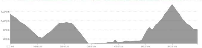

Les Gets Chatillon to Araches (7,8 km / 2,8%) Le Bettex (7,2 km / 7,7%)
CYKELNERVEN - STAGE 3
NEW - HUNTING THE ALTITUDE METERS

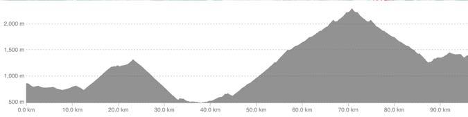
“Our planned route for stage three needs to be changed due to collapse of the roadway just before the summit of Cormet de Roselend. Passing the summit is impossible until July causing us to replace our planned two mountains. However, we will reach the same kilometers and elevation gains on two spectacular climbs to be challenged from Bourg St. Maurice.”
From our recent inspection trip to France just one and a half week before CYKELNERVEN’s arrival, the authorities unfortunately announced that major work on the roadway makes it impossible to pass Cormet de Roselend. As we do not want our riders to cycle 145 km to pass first COL DES SAISIES to Beaufort and then transfer on bikes all the way to Bourg Saint Maurice, we have changed the planned stage.
From Saint Gervais, we depart in busses Friday morning approximately at 08:00 for a transfer to Bourg Saint Maurice, which is an around two hours journey. Our coaches and truck drivers will organize the transfer of your bikes to be collected after finishing LE BETTEX on our second stage.
Arriving in Bourg Saint Maurice and at the Hotel Base Camp, our bikes will be ready for another day in the name of mountain cycling. First mountain will be CORMET DE ROSELEND, but the ascent will be from the other side than we originally had planned. This is nevertheless an extremely beautiful, but also challenging climb of nearly 20 km with an average grade of 5.7%. You will thereby succeed getting 1,095 meters of elevation gain on your charity highmeters account!
Bourg St. Maurice
Bourg St. Maurice
Bourg St. Maurice Cormet de Roselend
La Rosiére
Damiano Caruso did this climb in September 2020 (when the Tour de France was moved to September) with an average speed of 24.8 km/h and average power of 382W - and reached the top after 46 minutes and 29 second.
CYKELNERVEN riders will most likely enjoy the ride during a slightly longer trip, but with same touch feeling throughout the the rough terrain towards the summit.
Enjoy a safe descent same way down as you came up. But take care all the way down as the whole group of riders will go up this mountain side meaning a busy road decorated with riders promoting all the sponsors for this years charity event.
When you get back to the roundabout in BOURG SAINT MAURICE, you take the first road on the right and drive 900 meters up to Hotel Base Camp through two roundabouts. Grab some water, enjoy an energy bar and get ready for the second climb, which is LA ROSIERE.

 Cormet de Roselend
La Rosière was originally planned as a potential BONUS MOUNTAIN when arriving to Bourg Saint Maurice after stage 3 - but it is now part of the new official program. Read about the statistics and details for La Rosière in the forthcoming chapter BONUS MOUNTAINS.

After your descent to Seez, take the direction back towards Bourg Saint Maurice and you will return to the known roundabouts and can follow the road back to Hotel Base Camp for recovery, celebration and dinner.
If you challenge these two climbs, you will ride 90 km and 2,506 meters of elevation gain. Remember - choosing one or two climbs on this third day can make a difference for your fourth and last stage with COL DE LA LOZE as Grand Final of CYKELNERVEN 2023. It requires sufficient freshness and power to reach the the summit of the giant TdF-climb!

CORMET DE ROSELEND
LA ROSIÈRE
LES ARCS (1600, 1800, 1950, 2000)
Bourg Saint Maurice is certainly a perfect spot for the ability to challenge unique climbs and Tour de France montains. For those who previously have challenged Cormet de Roselend and/or La Rosière, the climb up to LES ARCS is just around the corner of Hotel Base Camp.
The climb offers various opportunties as ‘stations’ are in different heights.
It goes from heights of 1,600, 1,800, 1,950 and 2,000 meters , which reflects between 15 and 25 kilometers of ride from Bourg Saint Maurice.
It might be for those riders that are hunting the last meters of elevation gainbut there will not be any official routes or guided support on this climb.
If you consider riding this mountain, make sure that you inform coaches and the CYKELNERVEN sta equipment so you can continue you ride in the event of punctures and other defects. Riding from Bourg St. Maurice is

 Les Arcs 2000 before tunnel (21.3 km / 5.3%)

“Tough climbs, but still time and energy for smiles and expression of great honor having conquered another Tour de France mountain…”
CYKELNERVEN - STAGE 4

GRAND FINAL UP THE COL DE LA LOZE
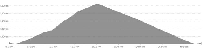
“The last and most challenging half of the 17th Tour de France stage lies ahead of us. You most likely have to dig deep after a few tough days - or perhaps you have prepared specifically for this Grand Final to Meribel and on to the iconic COL DE LA LOZE. It is a total climb of 35 km. It is a legendary summit that rounds off our great achievement - a summit that indeed also can decide the winner of this year Tour de France.”
The departure from HOTEL BASE CAMP goes towards CYKELNERVEN 2023's biggest challenge. This is the Grand Final with the steepest passages, in the roughest terrain and with the highest percentages of climb. It's a bit like a classic drama divided into 4 acts, where the tension continuously builds and you wait for the end - although it can also be 'dreaded' when the show is over!
Before we reach the final climb, we ride from the hotel towards the river L'Isére - approximately 1.5 km - from where we warm up our legs through small French villages on the mountain side. Exactly at kilometer 12.5 and before the town of Bonnegarde, we continue straight ahead, where the road would otherwise like to take us to the right. A dangerous intersection where traffic can come from the right and from behind - so stand by your group and focus on safety.
The ramp just in front of us marks the start of the day's first climb, CÔTE DE LONGEFOY, which continues towards NOTRE-DAME-DU-PRÈ. A good climb up through the forest of 6.6 km with an average gradient of 7.6%.
 Côte de Longefoy (6.6 km / 7,6%)
Notre-damedu-Prev Col de la Loze (28.4 km / 6%) Bourg St. Maurice
Moûtiers
Côte de Longefoy (6.6 km / 7,6%)
Notre-damedu-Prev Col de la Loze (28.4 km / 6%) Bourg St. Maurice
Moûtiers
(6.6 km / 7.6%) towards Notre Dame du Pré


After winding our way through the small town of Longefoy and we turn left towards the fields, there is a good opportunity to fill our bottles at the water station and gather all the team's riders.
At this point, we have been riding 18.6 km of the stage's 83 km, and approximately 580 meters of altitude out of a total of 2,740.
With more than 2,100 meters of altitude ahead of us, you should at this point still have energy and the positive spirit for the rest of our QUEEN STAGE. In addition to the climb to NOTRE-DAME-DU-PRÉ, which is 4.5 km, the remaining altitude meters come on the 35 km long climb, of which the last 28.4 km is the categorized Tour de France climb COL DE LA LOZE.
We stress that every rider must ride down safely and in a fully controlled manner from Notre-dame-du-Pré.
As shown on the map, there are countless hairpin bends and blind corners, which can cause a risk when many riders are descending at the same time. Pay attention, be considerate and drive sensibly. Coaches on the different teams ensure to bring together all riders in the respective groups after the bridge crossing the river L'Iseré.
It doesn't necessarily have to be easy to get to the foot of the COL DE LA LOZE, so we have a 4 km stretch on a large main road, where everyone drives one-by-one with a great focus on road safety. We are heading towards MOÜTIERS, which is a cozy French town full of atmosphere,
From
BourgSt.Maurice
Côte de Longefoy
!
which we only enjoy while rolling through the streets to get to the foot of the last final climb.
The ascent actually starts from kilometer 38 and the first 5 km stretch is again on a busy road. At this point it's good to get into the zone and into your personal climbing rhythm. Focus on dividing the climb into smaller sections so that the ride to the top is as manageable as possible. The last act must be planned well, because it is rare that you are faced with a categorized climb that is 28.4 km long - and that starts after you already have been riding uphill for 6.6 kilometers.
From your training rides in mountainous areas, you probably know your average speed on ascents with around 7-8% grades. You can therefore quickly calculate that you will be sitting in the saddle for several hours.

 Cöte de Longefoy (6,6 km / 7,6%)
Col de la Loze (28,4 km / 6%)
Cöte de Longefoy (6,6 km / 7,6%)
Col de la Loze (28,4 km / 6%)
The end of the classic drama has just begun. The profile of ascent clearly shows that the first 14 km of COL DE LA LOZE are the least challenging of the great mountain. Here it is primarily the blue and red, and some small green segments that shine through the kilometer markers. It is, after all, single-digit percentages of increase opposite when we get halfway up the last half of the climb, where the black color is pervasive!
At kilometer 58 and shortly after LA TANIA comes a short descent of 2.5 km which is the reason for Col de La Loze's misleading average grade of 'only' 6%.

When you reach the 62 km mark, you will meet the cheering and celebrating staff on the right-hand side of the car park, which is important to note. You probably won't pass by on your bike without noticing CYKELNERVEN's staff creating kind of a Tour de France atmosphere. Enjoy it as a wonderful and needed mental boost! You continue 400 meters further along the D90 and turn left, where you follow the signs for ALTIPORT and for ROND POINT DES PISTES. From the bend, it is 3 km up through winding roads, and you drive through an area with skiing hotels in the best French style.
Keep your focus on the bike computer's route so that you get right up to the Rond Point des Pistes, where you need to turn onto the ski slope. From here, you will have exactly 6 km to the top - first through a forest area which then transforms into a completely open landscape. After this,
the road winds all the way to the top and offers its violent segments with very steep passages. The mountain profile shows a maximum rise of 24% approximately 2 km from the summit. This is where you become really happy with the right gearing on your bike! And if you stall the only way up is to walk until you can safely start biking again.
Since the TRIP UP is the same way as the TRIP BACK to Meribel, it is extremely important that you stay on the right side of the road and always look up - regardless of possible exhaustion or the joy of soon being at the top. NEVER CROSS THE WHITE LINE - and please help ensuring that other riders also observe this important rule.
For riders who have been at the top and are going down, it is equally important that you keep your lane and pay close attention to the uphill riders. Although gradients on the ascent make it difficult to slow down on the descent, DRIVE AS CAREFULLY AS POSSIBLE. Show the greatest possible consideration for the sake of all riders!
Regardless of whether you get to the very top of the COL DE LA LOZE or up to the 'Rond-Point des Pistes', make sure you get to the car park for celebration and for busses transporting us back to Bourg St. Maurice. IMPORTANT: The MSIF riders should NOT place their bikes in racks, but instead hand over to the UK staff for separate transport to Base Camp.

4 ETAPE (75 KM / 2.578 HM)

BONUS MOUNTAINS
POSSIBILITY OF FURTHER ALTITUDE METERS
"If you suddenly feel you have surprisingly strong legs, and have the energy to climb additional mountains after stage 1 and 3, we give you the opportunity to conquer some BONUS MOUNTAINS. It is not part of the official routes and if you choose to ride, always inform your coaches and fellow riders before departure"
The first BONUS MOUNTAIN is after the 1st stage and it can eventually be driven after arriving back in Les Gets. The riders who consider to take on extra challenges should ride down to the start of the back road and up the COL DE LA RAMAZ from the Taninges side meaning opposite that first climb of stage 1. It is an 8.6 km climb with an average gradient of 7.3%.
Another alternative is the ride up to COL DE JOUX PLANE via the back side, which you have just driven down. A 10.3 km climb with an average of 6.7%.
 COL DE LA RAMAZ (8.6 KM / 7.3%)
The second BONUS MOUNTAIN is LA ROSIÉRE, a Tour de France mountain, which, however, is not included in this year's route. It starts from Bourg Saint Maurice and in the roundabout we reached after the descent from CORMET DE ROSELEND.


Here you take the 3rd exit and onto the D1090 and continue towards PIED DE COL and SÉEZ, from where the climb starts. Take the ROUTE DU PETIT SAINTBERNARD up through the winding roads. There are two routes up to the summit LA ROSIÉRE at 1,855 meters high. One way is 17.6 km up with a 5.8% average grade. Here you ride 1,018 of altitude meters.

The second route is 22 km and with approximately 4.8% average gradient.
Drive to the hotel to celebrate a BONUS MOUNTAIN and additional meters of elevation gains. The 17.6 km Strava route with the bonus climb starts from the Hotel Base Camp and goes to the summit of LA ROSIÉRE via the official Tour de France route. The return road takes the less steep but slightly longer route back to the hotel.
LA ROSIÉRE
KM / 5,8%)
The routes for the stages and for the bonus mountains will be distributed by email. Alternatively, they can be downloaded via the online version of this RoadBook directly from the following links:

Note! Read more about synchronization of routes between Strava, Garmin Connect, Garmin and Wahoo bike computers under the section ‘ROUTES'.
BONUSBJERG - COL DE LA RAMAZ (from Les Gets)
KLIK HER - DOWNLOAD
BONUSBJERG - LA ROSIÉRE (from Bourg St. Maurice, Base Camp)
KLIK HER - DOWNLOAD
(17,6
BOURG ST. MAURICE BOURG ST. MAURICE
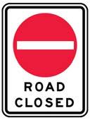
THE UNPREDICTABLE CHALLENGING WEATHER AND CLOSED ROAD
When we select the most spectacular stages with the expected decisive climbs, it is naturally from the perspective of cycling. We analyze the Tour de France presentation, review the stages and climbs - and we listen to experts before creating the drafts of the CYKELNERVEN routes.
The concept of riding the decisive climbs approximately one month before the professional riders take up the same battle also unfortunately sometimes means that preparatory actions to the Tour de France itself can challenge our detailed organization. We have previously experienced spontaneous mountain closures due to fallen rocks, sudden snowfall in the heights, and massive hailstorms even in mid-June.
In addition, the municipalities and cities involved are also repairing roads ahead of the Tour de France so that winter's weather does not create unsafe situations for the professional cyclists. Of course, the teams behind CYKELNERVEN cannot send any riders out on unsafe stages or on bad roads - and if roads and mountains are closed, then we have to find new alternatives as the next best solution!
We have ongoing dialogue with the French authorities via our Frenchspeaking partners. This has been going on since our first route draft on 27 October 2022 after the announcement of the Tour de France stages. We have been analyzing routes, time of riding, number of groups, riders and other practical things with road authorities and local French mayor's offices. But unfortunately we also experience that not everything can be predicted. No one knows the road conditions when the snow melts on the high mountains. Therefore, the unpredictable can also mean changes to the stage and the climb descriptions in this RoadBook.
During our recent inspection of routes on bicycles in France, the Col de la Colombiére was closed due to rock slides. Cormet de Roselend and Col de la Loze were closed due to continued heavy snow after the winter.
We do our best to continuously have insight into whether we can succeed with our planned stages. If safety and specific guidelines from the French authorities mean that we cannot drive the described routes, we then look at the possibilities, the good alternatives and the best possible solutions.
COL DE LA RAMAZ
At the end of May, we were informed that asphalt work must be carried out after the winter season. It concerns the descent from Les Gets. We are in dialogue with the authorities for deeper insight and have ongoing dialogue with our contacts at the hotels in Les Gets, where we are staying for two nights.
In the event that the COL DE LA RAMAZ is closed from the top towards Les Gets, the official route will be changed so that we drive down the mountain the same way we drove up. This does not change the fact that we continue to have a lunch depot in Taninges and we continue to run COL DE JOUX PLANE as planned. The change will correspond to an approximately 5 km longer stage.
COL DE LA COLOMBIERÈ
This climb has also been closed off after the winter period due to rock slides and smaller pieces of snow. The climb is not that high and we are therefore optimistic about our ride in June. This mountain is not a tour mountain for this year's Tour de France, but a mountain we pass on the long route for stage 2.
CORMET DE ROSELEND
As described during the stage three analysis, suddenly established major roadwork until July has caused a closure of the mountain from the Beaufort side. This is why we have changed our planned stage three.
COL DE LA LOZE
At the end of May, there is still a massive snow covering the COL DE LA LOZE, but mainly from the Meribel side. The road from 'Rond Point des Pistes' and 6 km further to the top is partly blocked. We are in dialogue with the authorities regarding the prospect of opening the route based on previous years' experience and current weather forecasts.

Of course, we always respect road closures and official road closures, and we have therefore already prepared a PLAN B as the best possible alternative to get to the peaks.
The route from COURCHEVEL and Courchevel Village and on to La Loze gives a distance of 96 km with 2,982 meters of elevation gain. In the event that PLAN B comes into action, we will reach the top of the COL DE LA LOZE, but from the other side than the official Tour de France climb for the 17th stage. However, the important height meters for the collections are not affected - on the contrary!
PLAN B FOR REACHING THE TOP OF COL DE LA LOZE

THE ENERGY PLAN
ENERGY FOR SUCCEEDING THE STAGES
When you have set yourself a dedicated cycling goal, it is of course important to prepare properly, but without the right intake of food, drink and energy during training and during the goal itself, it can be problematic to achieve.
We will therefore briefly describe some of the key-points we believe are important in order to perform optimally during CYKELNERVEN 2023.
ENERGY
As you most likely are fully aware of, it takes a lot of energy to get through an event like CYKELNERVEN. First you spend many hours building up the right level of fitness. But your ability to deliver enough energy to your working muscles is also important. Most people may know a friend who can do a really speedy ride for 60-90 minutes, but then “breaks down” completely. There is no point in building a bigger engine if the fuel hose is too small - or there is no petrol in the tank.
So through your recent ENDURANCE TRAINING, you can figuratively train your fuel hose to become bigger. However, it doesn't help much if the tank is empty, so an important element for our 4-day cycling event is about having the right nutrition strategy.
When we eat and drink energy, it first goes down into the stomach, where liquid and sugar can be absorbed. But if we eat more complex things, such as a French chicken sandwich, some of the food must first go down into the intestine before it is absorbed. Therefore, the rate of the stomach emptying has impact on how how quickly we absorb the energy and also the so-called 'osmotic' ratio.
You might already know this, but the latest research points to the fact that the intake of carbohydrates is trainable. We can therefore train our bodies to absorb larger amounts of carbohydrate - and as carbohydrate is our most efficient source of energy during intensive work, this is a focus point.
It has always been a rule of thumb that we had a maximum possible intake of 60 grams of carbohydrate per hour. However, this studies now show uptake as high as 120 gram per hour, which we should not strive for if you have been used to much lower intake.
Assuming a higher intake, you can work harder and longer than before. At Team Ineos, they use water bottles with the so-called Rocket Fuel. This is not about illegal substans, but a special combination of carbohydrates that enables the high uptake. The mixture is maltodextrin and fructose in a ratio that is specially adapted to the individual rider. Since the body has different “access ports" to absorb different carbohydrates, you can therefore go to the maximum limit for each type of port. It could be the Pure Power product CARBO RACE ELECTROLYTE, where there are long and short sugar structures.
A key advantage of this are that the energy is released over a slightly longer period of time and the body can absorb it in different ports. An as illustration: Imagine a train where all passengers want to go through the same door. It creates congestion and there will be a rush to get out. If you use all the doors, everyone will be able to get out and without crowding.
WATER
With four tough stages ahead, the energy intake is surely important, but many forget the critical focus on liquid. For absorbing energy from food, energy products or sweets, it depends on the ratio between liquid and energy being correct. If we do not get enough liquid, it will be difficult to absorb the energy that is lying in the stomach. So even though energy is important, you must remember to drink enough clean water, and the amount depends on the heat and size of the rider as well as the individual rider's loss of liquid over time. Our important recommendation is to consume approximately 1 LITER OF CLEAN WATER per hour.
ENERGY BARS
The advantage of an energy bar is that the absorption of the energy comes gradually and the blood sugar does not fluctuate violently. Therefore, you can perform more optimally and with even a stable absorption. It could be with Pure Powers ENERGY SNACK, which are large but can be eaten over a period of time. Better to consume a little every quarter than a whole at once. A downside is that you don't get a big quick burst of energy all at once, so timely care is important if you prefer bars only.
alternatives for those who need a quick energy intake to get the best boost. These products work quickly, but require you to dose them correctly, otherwise you may experience fluctuations in your blood sugar and potentially ups and downs of your performance on the bike.
ELECTROLYTES
Electrolytes do not provide energy but help maintain optimal salt and mineral levels. It can also help you drink sufficient portion of water as the tastes makes it more enjoyable. Electrolytes are however not a requirement if you eat and drink healthily, but can be a good way of getting the liquid in balance after a long and tough day in the saddle.
If the weather is hot, we recommend that you drink one bottle of electrolytes before the stage and one immediately after.

SO WHAT TO DO IN PRACTICE?
1. Continue your training with energy in the bottles until departure. Test the principles of energy and fluid that we have described in this RoadBook.

2. Potentially, slowly work your way up in concentration towards the 90 grams per hour. Especially use the last long training rides to test the energy intake. Always think "eat before you're hungry / drink before you're thirsty".
3. Prepare your plan before departures. You should aim to get approximately one liter of liquid per hour to your desired energy intake but regulated according to the temperatures. If it is very hot, a less concentrated mixture may be a good idea.
4. Start by drinking of water/electrolytes bottles after breakfast.
5. Consume bites of an Energy Bare already from the start of the ride. But you can't eat your way into shape so the intake should be moderate.
6. Bring gels so you can support your body if urgent needs arises. Otherwise rely on bars, lunches and energy drinks at the depots.
7. Bring a bottle with clean water. Then you can always consume your
de France-climbs!”

“We challenge the decisive Tour
ENERGY - PUREPOWER ENERGY PRODUCTS DURING THE EVENT
We have described both the physical requirements for the stages, and also described the energy demands for the decisive Tour de France climbs. Regardless of the pace of the rides, the many hours on your bike will require a lot of effort - and you will certainly need a well-planned energy strategy and intake.
We help you with this by providing various energy products. All riders will be given a goodie bag upon arrival at the hotels in Les Gets. The content will include energy products from Cykelnerven's energy sponsor PurePower.
Each rider will get the following products:
4 Energi Snacks


4 Gels
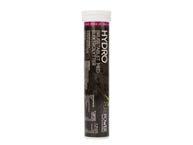
4 Chews Hydrotabs (20 tabs)

2 PurePower water bottles
Note! It is important that you plan your strategy with additional energy products than the above based on your own needs and experiences from training and previous cycling trips in the mountains. In particular, use the experience from the long rides to assess how much and which energy is needed and when - in addition to the liquid.
REMEMBER! Show up to the stages with full bottles. Before the start, you will have the opportunity to add Carbo Race Energy Powder from PurePower - which will also be available at the lunch depots.
DEPARTURES & ARRIVALS DATES AND TIME SCHEDULE
Tuesday 6 Juni
18:15
19:00
Expected arrival for the majority of riders - Les Gets, France
Welcome to all riders - Location: ’La Sal Colombier’, Les Gets
20:00 Dinner - Simple and solid ‘Italian Lasagna'
Wednesday 7 Juni - Stage 1
06:30 - 08:00 Breakfast at the hotels
08:00
08:45
15:00-16:30
Preparation of bikes and energy
Departure for stage 1 (87 km / 2,332 hm)
Expected arrival in Les Gets
19:00 Dinners - at Hotel La Marmotte and Hotel Alpina
Thursday 8 Juni - Stage 2
06:30 - 8:30 Breakfast at hotel / Bagage drop-off (08:00)
08:00
08:15
08:30
17:00
Departure - Stage 2: Le défi cycliste extrême (130 km / 3.202 hm)
Departure - Stage 2: Middle distance (99 km / 2.149 hm)
Departure - Stage 2: Short distance (69 km / 1.365 hm)
Expected latest arrival in Saint Gervais (after climbing Le Bettex)
19:00 Dinners - Hotel Saint Gervais and Hotel Sowell
Friday 9 Juni - Stage 3
06:30 - 08:00
08:00
10:30
16:00-17:00
Breakfast at hotels
Departure by busses to Bourg St. Maurice including bagage
Departure - Stage 3 from Hotel Base Camp (90 km / 2.506 hm)
Expected arrivals in Bourg Saint Maurice at Hotel Base Camp
19:00 Dinner at Hotel Base Camp - All riders
Saturday 10 June - Stage 4
06:30 - 8:30 Breakfast at Hotel Base Camp
09:00 Departure - Stage 4 (83 km / 2.740 hm)
15:00-16:30
16:00-17:30
19:00
Expected arrival at the parking areas i Meribel
Celebration and bus transfer to Bourg St. Maurice
DINNER and announcements of fundraising - Hotel Base Camp
Sunday 11 Juni - Departure to airport
05:30 - 09:00
Breakfast and departures in busses towards airports
You will receive specific information about departures and busses
MUSETTE BAG FOR DRY CLOTHES BEFORE DESCENT

On arrival at the hotels in Les Gets, together with the energy pack, you will be given a 'musette bag’ to be used for dry clothes for potential cold descents.
This year, all musettes are black with ONE NUMBER, which you have to remember yourself.
Learned from previous Cykelnerven events, it is a good idea to enter your number as a note in your mobile phone / or take a picture. The musette is used so that you can pack a dry shirt, sleeves, a rain jacket or similar for any cold and/or wet descents.
The musette is delivered every morning to CYKELNERVEN service and support cars at the starting point before departure. It can generally be accessed on the highest or first mountain every day - which means COL DE LA RAMAZ for the 1st stage. For the 2nd stage (short and medium distance), the bag can be accessed at LE BETTEX. For long routes, lunch will be provided by car. On the 3rd stage it will be placed at HOTEL BASE CAMP. For the 4th stage, it will be the lunch depot before the top of NOTRE-DAME-DU-PRE.
You will receive additional information about specific locations during the daily evening briefings and via Text Messages and in the Web app in the event of any changes in the logistics.
The musette will then be handed out every evening at one specific dinner restaurant. Pick it up and prepare your musette again for the next day's stage.

PERSONAL NOTES GOALS & FOCUS POINTS
HOTELS ADRESSES AT HOTELS
TUESDAY - THURSDAY: LES GETS
HOTEL LA MAMOTTE
61 RUE DU CHÊNE, 74260 LES GETS, FRANCE
HOTEL ALPINA
55 IMPASSE DE LA GRANGE NEUVE 74260 LES GETS
LES CHALET DE ALDEPHINE
338 RTE DE LA TURCHE, 74260 LES GETS,
HOTEL BELLEVUE
125 RTE DU FRONT DE NEIGE, 74260 LES GETS,
HOTEL CHAMOS D´OR
826 RUE DU CTRE, 74260 LES GETS
HOTEL CHRISTIANIA
407 RTE DU FRONT DE NEIGE, 74260 LES GETS, FRANKRIG
WELCOME AND PRESENTATION - LOCATION:
SALLE LA COLOMBIÈRE,
2813 RTE DES GRANDES ALPES, 74260 LES GETS, FRANKRIG
HOTELS ADRESSES AT HOTELS
THURSDAY - FRIDAY: SAINT GERVAIS
HOTEL SAINT GERVAIS
680 RUE DE MONT LACHAT 74170 SAINT GERVAIS
SOWELL HOTEL MONT BLANC
400 RUE DU MONT JOLY, 74170 SAINT-GERVAIS-LES-BAINS,
HOTEL COEUR DES NEIGES
64 CHEM. DU VIEUX PONT, 74170 SAINT-GERVAIS-LES-BAINS,
FRIDAY - SUNDAY: BOURG SAINT MAURICE
BASE CAMP LODGE
AROLLES, IMP. DES PEUPLIERS, 73700 BOURG-SAINT-MAURICE,
HOTEL L´AUTANTIC
69 RTE D'HAUTEVILLE, 73700 BOURG-SAINT-MAURICE,
PRACTICAL INFORMATION VIA SMS AND THE EVENT APP
All riders will continuously receive information via Text Messages during the stages about hotels for the next night, places to eat, times and other practical information.
There will also be a web app available during the event so you can keep up to date with practical information.
More information from Travel Sense will follow.
COACHES GUIDANCE, ROUTES AND STRONG SUPPORT
We strive for creating four really good and safe stages in the Alps. We therefore have 20 volunteer coaches to help with guidance, routing and general support - and other practical things throughout the event.
into the stages. They will guide your and support along the way, help with punctures and generally try to create a strong and secure event. It requires good cooperation with you and all the other riders. Remember to contribute to the good atmosphere, give constructive feedback and listen to advice and recommendations.
We expect to ride in 9 teams, which will give 24-28 riders on each team. Level and team divisions are based on answers from a questionnaire. For each of the teams, two coaches will be responsible for a good stage. One coach drives at the front, guides, communicates and shows the way - and one coach is at the back and ensures that the team drives safely and that everyone are within the group on climbs with them. Coaches naturally also focus on great social gatherings within the teams.

ROUTES STRAVA LINKS AND ACCESS TO FILES
Via the online version and the PDF version of this RoadBook, you can click on the links below to access the training platform STRAVA and the planned routes.
Stage 1: Click HERE for download
Stage 2: Click HERE for download
Stage 2: Click HERE for download (MIDDLE)
Stage 2: Click HERE for download (LONG)
Stage 3: Click HERE for download
Stage 4: Click HERE for download
You can mark the above routes in Strava through the ‘star' and synchronize with your GarminConnect profile / Garmin device or your Wahoo computer. Or you can export as GPX file and download to your device. See the manual for details. The routes are used by coaches as well as by staff in supporting vehicles.
Although the routes are available via this RoadBook, there may be changes towards departure due to road works, asphalt work, new unsafe traffic sections, etc. It will always be coaches who lead the way and make any decisions about changes - these will be communicated either before departure or during the stages themselves, if conditions mean that we have to change the planned routes.
Regardless, we encourage you to check the distance and altitude of the stage immediately before departure - ask your coach! This means that you and all other riders have the same route and plan as the coaches and sta
DOWNLOAD THE ROUTE TO YOUR CYCLE COMPUTER
It is a good idea that as many riders as possible have downloaded the routes to their cycling computers. Thereby, you can assist each other along the way about when the peak is reached.
(Important! All stages and climbs will be inspected in the days before the groups of riders arrive in the Alps. It is recommended that files are downloaded or synchronized on the evening of Monday 5th June)
ff.
(Relevant in the online version of the RoadBook)
IS YOUR BIKE READY? … AND WITH RIGTH GEARING?

All riders should bring a bike which is setup in the correct way, reviewed by a professional mechanic and thereby ready for riding in the mountains.
We recommend that you choose a Compact crankset consisting of two rings. The gearing on such a crankset is often 50 teeth (large chainring) and 34 or 36 on a small chainring. For most participants, it must be combined with a mountain cassette on the rear wheel. The mountain erent gear combinations depending on which gear
group you have mounted on the bike. We recommend that you choose a cassette with a minimum of 30 teeth. If you are an inexperienced rider, then a 32-34 tooth cassette is recommended, depending on what the gear group allows. Always ask a professional for advice if you are in doubt!
Importantly! When you change the crank set/blades and/or the cassette, you change the chain at the same time. After shifting, you should have tested your bike and tested gear shifting from lightest to heaviest, so that the adjustment does not have to be made in France before departure.
end to completing the stages in France. In addition, both uphill and downhill journeys make demands on the safety of your bicycle.
We therefore expect all riders to bring a bike that is serviced and ready for riding in the French Alps.
We recommend also to bring the following:
- New brake pads both front and rear (plus extra in the luggage)
- New tires fitted on both front and rear wheels (not thin racing tires)
- Purchasing the right tubes, mini-tool and pump, additional cleats for shoes
- Extra gear drop
Check your tires! After training rides or before setting off on a new stage, it should be rutine to check the tires for pebbles and small holes. At the same time, it provides a good opportunity to get the right tire pressure, which is of importance for a good experience in the saddle.
Check the side of your tire and fill to the recommended pressure - often it is between 6.5 - 8.0 bar. There will be pumps available before departure.

MECHANICS ASSISTANCE FOR YOUR BIKE

The preparation ahead of this big challenges is of course important. But no matter how thoroughly you have prepared for many months before the trip to France, the four stages will not be successful if your bike cannot "make it" or cannot last four challenging stages.
It is your own responsibility that the bike is ready when arriving in France.
If you cannot fix a defect yourself, an important adjustment or fi t necessary spare parts, we have our own mechanics in France as an additional service.
They will primarily assist with critical defects and adjustments that are necessary for a rider to continue on the bike either during the stage or before the start of the stage in the morning. Any spare parts are settled at your own expense.
In addition to being available as much as possible during our four stages, our mechanics will be present before and after the stages at a selected hotel in each of the cities we spend the night in. Additional info during the daily briefings or via SMS and Web app..

CYKELNERVEN CLOTHES
WE DRESS FOR OUR SPONSORS
We ride in our nice cycling clothes from Campione and we proudly show logos for the many sponsors who are helping to make a difference against Multiple Sclerosis.
It is therefore a requirement that all riders cycle in this year's cycling clothing all four days.
CONTACTS PERSONS TO CONTACT
CYKELNERVEN
Mette Hjulmand Leonhard-Hjorth, overordnede ansvarlige
Mail: mhj@scleroseforeningen.dk
Phone +45 2534 4449
Jakob Gura
Mail: jgu@scleroseforeningen.dk
Phone +45 2499 0581
Travel Sense
Mads Møller Sørensen
Mail: mads@travelsense.dk
Phone: +45 3117 2804
HEAD COACHES
Bo Velds Andresen Benjamin Justesen
Phone: +45 3024 0999 Phone: +45 5160 7100
DOCTORS
We have our own doctors with us. If it is assessed that urgent medical care is needed before, during or after the stages, call 112. Otherwise, Mette Hjulmand Leonhard-Hjorth or Jakob Gura should be contacted.
_____
_____
_____
THANK YOU - SPONSORS CYKELNERVENS SPONSORS