
guided walks
innatureSeventrails and Kingfisheraround Bay Resort
LAKE MCKENZIE (BOORANGOORA) CIRCUIT
ROUTE 1
2-2.5hrs each way 10-11km each way High uphill sections and steps
FORESTS OF FRASER WALK
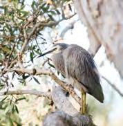
SPECIAL FEATURES Look out for musk ducks and pied cormorants that are often seen feeding on the island’s mirror lakes.
TRACK NOTES Walk from Reception towards the Village Store, then pass the fuel station and head up the bitumen road approximately 50m, where you will turn left off the road into a sandy service trail. The start of this trail is marked Beerillbee Trail/ Lake McKenzie Route 1.

Follow this fire trail uphill for approximately 800m, finally reaching a water tank at the top of the hill. The arrow will lead you to the path on the right, walking downhill for approximately 400m. You will then come to a track marker that indicates the walk to Lake McKenzie is 3.5hrs (where in fact it is only around 2hrs from this position).
At 3.3km you will cross over a small log bridge, which is Dundonga Creek, then
uphill to the crossing of Cornwell’s Road. Cross the road and follow the marked walking track to the next junction; this climb is long, but gentle.
On the southern descent you’ll cross the Lake Wabby Road, following the fire trail to the Northern Road. Cross this road (as indicated by the marker) and follow the walking track to Lake McKenzie Road. Once you reach this road the sign will indicate M6. You will now have the lake in sight.
Cross over the road slightly to your right and walk approximately 20m to a fire trail with a chain across the start. Walk around the chain and down the hill to the lake. If you stay on this trail in approximately 800m you will arrive at the picnic ground and the toilet facility.
TO RETURN TO THE RESORT
• Retrace your steps or return via Route 2.
ROUTE 2
MCKENZIE’S
JETTY WALK
TRACK NOTES Follow track notes for the McKenzie’s Jetty Walk. Standing at the ruins of McKenzie’s Jetty and facing toward the island, head inland approximately 30m up toward the picnic tables and information board. Ignore the road on the right and continue straight through the carpark to the trail for Lake McKenzie. This section is alongside a creek, so insect repellant is a good idea. You will cross a bridge and some fencing as you walk through the remnants of the McKenzie Mill. When you come to a junction (that says ‘Mill Circuit’ to the left) continue straight ahead 7.6km to the lake. When the walking trail meets a fire trail, turn right to follow the trail. You will then come to a junction in the road, follow the trail marker veering to the left.
Just as the road starts to incline, there is a signpost on the left where you will turn onto a narrow walking trail through dense vegetation.
3-3.5hrs each way
13-14km each way High uphill sections and steps
Part way along the trail you will cross a road, and then eventually come to a T-intersection. To the left is the alternate route to Kingfisher Bay Resort, here you will turn right for Lake McKenzie. After approximately 15 minutes of walking up a steep hill there is another junction, the signs indicate Lake Wabby and Pile Valley to the left, where you will turn right for Lake McKenzie.
The trail meets a road with signs for M6, which is the very busy Lake McKenzie Road. Cross over the road slightly to your right and walk approximately 20m to a fire trail with a chain across the start. Walk around the chain and down the hill to the lake. If you stay on this trail in approximately 800m you will arrive at the picnic ground and the toilet facility.
TO RETURN TO THE RESORT
• Retrace your steps or return via Route 1.
SOUTHERN LOOKOUT WALK
SPECIAL FEATURES Spectacular views from the top of the dune over the Great Sandy Strait to Hervey Bay including Big Woody, Little Woody, Picnic and Duck Island.
TRACK NOTES From the Village Store follow the bitumen road up the hill to the junction. Turn right and walk about 1 min before turning left at the sign. Follow the bitumen road with the villas on your right.
Turn left up the small bitumen track before turning left up the
sand track and past the picnic table. Continue to the top of the hill where the track meets the dingo fence and gate. Go through the gate and then straight ahead to the Lookout.
NOTE: Please take care at the cliff edge.
TO RETURN TO THE RESORT

• Retrace your steps
NOTE: Please be aware of approaching vehicles when walking along the road
REMINDER: Before commencing your walk, advise our reception team of your travel plans. Due to minimal phone reception once leaving the resort perimeter, we recommend taking a screenshot of your track notes as an easy reference.
REMINDER: Before commencing your walk, advise our reception team of your travel plans. Due to minimal phone reception once leaving the resort petimeter, we recommend taking a screenshot of your track notes as an easy reference.
1 2
45-55min return 2.3km return Moderate uphill sections
3 CONNECT WITH THE ISLAND'S WORLD HERITAGE-LISTED SURROUNDS
-
LAKE MCKENZIE (BOORANGOORA)
SPECIAL FEATURES Wildfire-affected regenerating bushland can be seen. Look for large forest trees with hollows inhabited by sugar and squirrel gliders, cockatoos, lorikeets and forest kingfishers. Conical-shaped bandicoot diggings can be found along the track, particularly near fungi and underneath some wattle tree species.
GREAT SANDY STRAIT WALK

1.2km each way
left. Continue left on Beerillbee trail about 20 mins to a bitumen road. Go straight across this road onto a wide sand track.
Follow the Beerillbee sign and continue on this wide, sandy track for approx. 500m until you reach the Great Sandy Northern Outlook.
TO RETURN TO THE RESORT
• Retrace your steps back to the Village Store.
• Turn left at the lookout and follow the sand track downhill to The Sand Bar and the Sunset Bar (see Great Sandy Strait walk for more information).
20-30min each way
SPECIAL FEATURES Walk through eucalypt woodland and spot the scarred tree. There is a sensational view when you reach the top so don’t forget your camera.
Moderate uphill sections and steps
bandicoot small holes and echidna diggings along the track.
When you reach the lookout, you’ll spot shorebirds and marine life including dugongs, stingrays and humpback whales in season from August until October.
TO RETURN TO THE RESORT
• Retrace your steps down to the Sunset Bar.
• Turn your back on the lookout and follow the wide sand track back to the bitumen road. Turn right and walk downhill along the road to the roundabout in front of the resort’s main reception. Please be aware of traffic on the road.
TRACK NOTES From the Village Store take the bitumen road approximately 1 min uphill. Turn left onto the dirt track directly after this sign before the junction to exit the resort.
Follow this dirt track for about 5 mins uphill until you come to the Beerillbee trail sign on left (Lake McKenzie trail is on the right) You will see villas on the
MCKENZIE’S JETTY
LOW TIDE ROUTE
SPECIAL FEATURES McKenzie’s Jetty was built to accommodate the logging trade on K’gari (Fraser Island), pylons from this disused jetty can still be seen today and make for stunning photos at dawn and dusk.

• Turn right at the lookout, follow the sand track through the dingo fence and descend to Dundonga Creek. Walk along the south bank of the creek towards the ocean and return south along the beach to the Sunset Bar (see Dundonga Creek walk for more information).
NOTE: This third option is not suitable at high tide. You’ll find today’s tide times in the What’s On Guide.
7
TRACK NOTES From the Sunset Bar, cross the road and walk towards the sign ‘Balarrgan Circuit and Northern Outlook’.
Continue along the track behind the volleyball court. Walk up through eucalypt woodland to the Northern Outlook. Enroute, keep an eye out for
• Turn right at the lookout, follow the sand track through the dingo fence and descend to Dundonga Creek. Walk along the south bank of the creek toward the ocean and return south along the beach to the Sunset Bar – (See Dundonga Creek walk for more information).

NOTE: This third option is not suitable at high tide.
HIGH TIDE ROUTE
TRACK NOTES Follow track notes for the Southern Lookout Walk. Once you pass through the dingo fence gate, head downhill for about 30m. You will see a sign post marker stating ‘Fraser Commando School 1.9km McKenzie’s Jetty 2.6km’.
Continue on track. It is well marked with arrow markers for about 40 min until you arrive at the WW11 Commando School interpretive shelter.
TRACK NOTES This track starts on the beach in front of the resort. To start, face the water and turn left and walk south along the beach for 2.5km until you reach the jetty. Please note small tidal pools can be present at low tide.
TO RETURN TO THE RESORT
• Retrace your steps.
• Continue onto WWII Commando School site and return via inland track. This is also the high tide track.
NOTE: You can reach the WWII Commando School site from the McKenzie’s Jetty please see the WWII Commando School walk option 1.
To continue on to McKenzie’s Jetty, follow the signs for another 700m towards the ocean.
TO RETURN TO THE RESORT
• Retrace your steps.
• Head back along the beach, low tide option.
• See option 2 of WWII Commando School walk.
REMINDER: Before commencing your walk, advise our reception team of your travel plans. Due to minimal phone reception once leaving the resort petimeter, we recommend taking a screenshot of your track notes as an easy reference.
REMINDER: Before commencing your walk, advise our reception team of your travel plans. Due to minimal phone reception once leaving the resort perimeter, we recommend taking a screenshot of your track notes as an easy reference.
BEERILLBEE
30-45min each way 4km each way Moderate uphill sections and soft sand
TRAIL
4
5 1.5hrs return 1.2-1.5hrs return 5km return 4.4km return Moderate some soft sand Moderate some hills
6
WALLUM BOARDWALK
SPECIAL FEATURES Views from the Great Sandy Northern Outlook are breathtaking as you look over the Great Sandy Strait towards Hervey Bay, Picnic and Woody Islands. Old growth mangrove forests are alive with butterflies and specialised birdlife.
WW11 COMMANDO SCHOOL WALK
ROUTE 1
TRACK NOTES From the Sunset Bar, take the trail behind the volleyball net, that’s signposted ‘Balarrgan Circuit and Northern Outlook’.

Walk up through eucalypt woodland to the Northern Lookout. This is the perfect place to scan the Great Sandy Marine Park for dugongs, dolphins, turtles, stingrays and humpback whales in season (August to October).


Continue over the hill, through the dingo fence and descend to Dundonga Creek. Walk along the south bank of the creek towards the ocean.
TO RETURN TO THE RESORT
• Retrace your steps up the hill to the Northern Outlook.
• Continue along the beach back to the Sunset Bar. The intertidal zone is teeming with soldier, sand bubbler and ghost crabs, beach worms and elephant snails. Rays, fiddler crabs and many species of fish, particularly juveniles also inhabit the creek and its banks.

NOTE: This walk is not suitable at high tide as Dundonga Creek becomes a deep, fast-flowing stream at this time. The beach walk should not be attempted within two hours either side of high tide. Please check tide times before departure (you’ll find them in the resort’s What’s On Guide) and ensure you leave enough time to complete the walk safely. Times are slightly longer if returning along the beach.
SPECIAL FEATURES Between 1943 and 1945 several hundred soldiers trained on K’gari (Fraser Island) before being deployed into Asia. Explore the ruins and the interp shelter to learn more about the Z-Special Unit.
TRACK NOTES From McKenzie’s Jetty, cross over the creek to a marker stating ‘Fraser Commando School
ROUTE 2
SPECIAL FEATURES Good vantage points of the Great Sandy Strait and surrounding islands. Look up into the tall eucalypts and you may spot the stick-piled nesting platforms of the white-breasted sea eagles.
TRACK NOTES Back at the interpretation shelter continue along the walking track towards sign ‘Kingfisher Bay Resort 3.7km’. This track is well marked so keep following the markers. After about 25-30mins, near one of the lookout points, you will see a walking track marker post and
650m Kingfisher Bay Resort 3.7km’. Continue uphill for 15 minutes until you reach a small interpretation shelter, this is the commando school site.
TO RETURN TO THE RESORT
• See option 2.
sign for ‘Kingfisher Bay Resort 950m’. Head uphill for about 30m and you’ll come to the dingo fence with the gate. Once inside the fence, head right at the T-intersection. In another 3-4min you will see a walking arrow pointing left downhill along a 4WD track, follow this sign. You will arrive at a sealed road in another 5 minutes, cross over and take the narrow foot track heading down the hill via the villas and onto a boardwalk. Head left on the boardwalk until you come to a sealed road where you will see Kingfisher Bay Resort.
REMINDER: Before commencing your walk, advise our reception team of your travel plans. Due to minimal phone reception once leaving the resort petimeter, we recommend taking a screenshot of your track notes as an easy reference.
REMINDER: Before commencing your walk, advise our reception team of your travel plans. Due to minimal phone reception once leaving the resort perimeter, we recommend taking a screenshot of your track notes as an easy reference.
25-40min each way 1.75km each way Moderate uphill sections and steps 8
DUNDONGA CREEK WALK
15-20min each way from
40-50min each way 700m each way 3.7km each way Moderate steady uphill climb Moderate some hills
McKenzie’s Jetty to Kingfisher Bay Resort
9 10
WESTERN BEACH
NORTHERN OUTLOOK
WALLUM BOARDWALK
TAKE TO THE TRACKS IN AND AROUND KINGFISHER BAY RESORT

What better way to immerse yourself in the sights and sounds of World Heritage K’gari (Fraser Island), than by taking time to smell the wildflowers and enjoy stunning views along the western bay. There are a number of short or full-day walks for keen adventurers in and around the resort. Check out our selection of the top trails!
STAYING SAFE
• Always wear sturdy footwear, take plenty of water, a map, zinc sunscreen, hat and a first aid kit with you. In Queensland, we recommend that you avoid walking in the hottest part of the day. Inland walking trails are closed over summer for visitor safety.
• Please notify the team at Reception on your intended route, departure/ return times and the number of walkers. Also advise the team at Reception when you return.
• Make sure you stay on the tracks, following trail markers and remain as a group.
TREAD LIGHTLY
We invite you to help us care for K’gari (Fraser Island) by only taking photos and only leaving footprints.
• To avoid damaging the fragile flora and fauna, please keep on the roads and walking trails.
• Litter doesn’t belong in our pristine environment and can be harmful to
wildlife. Please be eco-friendly and pick up any rubbish you see and dispose of correctly.
• Keep our waterways clean by using zinc sunscreen and natural insect repellents. Make sure you also wait the recommended application time before swimming.
• K’gari contains many spiritual and culturally significant sites, connected to the island’s traditional owners, the Butchulla people. Please be respectful of the land.
RESPECT WILDLIFE
Feeding, touching and approaching native animals alters their patterns of behaviour, endangering them and/or yourself.
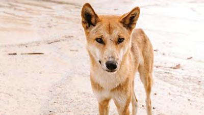
BE DINGO SAFE
• Don’t feed the animals.
• Keep children closeby and walk in groups.
• Don’t take food to lake shores or beaches. Use dingo-fenced picnic areas.
• If you feel threatened, stand to your full height and face the dingo with your arms folded. Keep eye contact and back away calmly. If in pairs, stand back-to-back. Never run or wave your arms.
• Wait until the dingo or dingoes are gone before you continue on your way.
PACKING CHECK LIST
• Enclosed shoes
• Drinking water
• Navigation tool (map and compass)
• Backpack
• Sunglasses
• Zinc sunscreen
• Insect repellent
• First aid supplies
• Towel (Lake McKenzie)
• Swimwear (Lake McKenzie)
• Notify reception of your travel plans
DINGO (WONGARI) CALENDAR
Dingoes are wild animals and their natural behaviour changes throughout the year. They show more aggressive behaviour in autumn and summer, as they are competing over food and for dominance over other dingoes in the pack. K’gari (Fraser Island) dingoes are predicted to become the purest strain of dingo on Australia’s east coast.
AUTUMN (MAR-MAY)
Mating season is a time for testing dominance, protecting territories and expelling intruders from other packs.
WINTER (JUN-AUG)
Although the whole pack pitches in, a female dingo with pups is naturally protective and potentially aggressive. She needs to provide by finding food for herself and her pups. Unlike domestic dogs, dingoes only have pups once a year.
SPRING (SEPT-NOV)
Pups are learning island survival skills from their parents. If potential food sources from humans are available, pups may not learn natural hunting skills. It is illegal to feed dingoes.
SUMMER (DEC-FEB)
These protected animals learn pack rules through play and showing innate aggressive behaviour to gain dominance. Young dingoes will try to dominate people, especially children and dingo safety is required.
RANGER-GUIDED ACTIVITIES
Phone reception on K’gari (Fraser Island) is limited and aeroplane mode should be used to conserve battery. Use your map and observe all signs on your chosen trail.
The walking tracks are maintained by Queensland Parks and Wildlife. Most trails are signposted, with a generally firm and stable sand surface. Walkers should expect sections of soft sand.
Our team of Eco Rangers are often spotted around Kingfisher Bay Resort, running a series of daily nature-based walks, informative talks and guided activities.

Our island ambassadors have an immense passion and knowledge for the destination, with backgrounds in Animal Ecology, Marine Science, Australian Indigenous studies and more. Together, they enhance each travellers’ experience on the wild and wonderful paradise, that is K’gari.
• Ranger-guided Wallum Walk
• Ranger-guided Eco Walk
• Ranger-guided Beach & Mangrove Walk
• Ranger-guided Bush Tucker Walk
• Ranger-guided Great Sandy Strait Walk
• Ranger-guided Night Walk
REMINDER: Before commencing your walk, advise our reception team of your travel plans. Due to minimal phone reception once leaving the resort perimeter, we recommend taking a screenshot of your track notes as an easy reference.
REMINDER: Before commencing your walk, advise our reception team of your travel plans. Due to minimal phone reception once leaving the resort petimeter, we recommend taking a screenshot of your track notes as an easy reference.
Source: Queensland Parks and Wildlife.WALKING TRAILS MAP time to explore
WALKING TRACKS
Great Sandy Strait Walk
McKenzie’s Jetty Walk Low Tide Route 1
REMINDER: Before commencing your walk, advise our reception team of your travel plans. Due to minimal phone reception once leaving the resort petimeter, we recommend taking a screenshot of your track notes as an easy reference.
REMINDER: Before commencing your walk, advise our reception team of your travel plans. Due to minimal phone reception once leaving the resort perimeter, we recommend taking a screenshot of your track notes as an easy reference.
TOLAKEMCKENZIE (BOORANGOORA) THE NORTHERN LOOKOUT DINGO (WONGARI) FENCE DUNDONGA CREEK DINGO (WONGARI) FENCE EASTERN FOREST ESTATE HEIGHTKINGFISHER S ESTATE WILLIAM EDWARDSON LANE JOSEPHBANKSCRESCENT COOLOOLA VILLAS THE SAND BAR BEACH VOLLEY BALL COURT SUNSET BAR HELIPAD WALLUM BOARDWALKS CENTRE COMPLEX BANKSIA VILLAS TENNIS COURT FERRY RAMP KINGFISHER BAY JETTY WONGARI DEN SHOPPING VILLAGE PANDANUS VILLAS HOTEL ROOMS A WING HOTEL ROOMS B WING SUNSET BEACH SOUTHERN SUNSET ESTATE SATINAYVILLAS GREAT SANDY STRAIT SUNSET BEACH
OPTUS TOWER RESORT EXIT TO NATIONAL PARK TO EASTERN BEACH DINGO (WONGARI) FENCE SOUTHERN LOOKOUT 1 SOUTHERN LOOKOUT 2 COMMANDO SCHOOL SOUTHERN LOOKOUT 3 MCKENZIE'S JETTY (TOLAKEMCKENZIE
KINGFISHER BAY RESORT DUNDONGA CREEK NORTHERN ROAD NORTHERN ROAD BENNETTROAD LAKEROMCKENZIE AD LAKE MCKENZIE (BOORANGOORA) MCKENZIE'S JETTY KINGFISHER BAY RESORT 1 1 1 1 2 2 2 2 2 3 3 4 4 4 4 5 5 6 6 6 6 7 7 7 8 10 9 9 9 10 8 8
BEERILLBEEWALKINGTRAIL
BOORANGOORA)
Southern
Beerillbee
Lake McKenzie (Boorangoora) Circuit Route 1 Lake McKenzie (Boorangoora) Circuit Route 2
Lookout Walk
Trail
McKenzie’s Jetty Walk High Tide Route 2 Dundonga Creek Walk
WWII Commando School Walk Route 1 WWII Commando School Walk Route 2 Kingfisher Bay Resort Boardwalks
Please note: map is not drawn to scale and is indicative only.
Dingo (Wongari) Fence
LAKE MCKENZIE (BOORANGOORA) CIRCUIT