ON CLIFF’s EDGE
Inside
The Fix The Problem
One aquarium has taken a unique approach to tackle the growing climate crisis.
See more B2
Erosion has slowly been eating away at California’s coasts, here’s a highlight of the problem.
See more B2

The Effect The Culture
Past and Present: California’s coastal erosion’s history and modern day effects.

See more B3
A grafitti culture thrives in the heart of one of Califoria’s largest community disasters.
See more B3


@ECCUNION ECCUNION.COM June 1, 2023
THE UNION
Photo by Ethan Cohen
Tiny aquarium leads charge to heal coasts
Cabrillo Marine Aquarium in San Pedro nurses endangered species to be reintroduced into wild
By Kim McGillThe Cabrillo Marine Aquarium in San Pedro focuses on education, research and conservation to connect people to the underwater world of Southern California.
School visits, beach cleanups and interactive exhibits put people in contact with some of the region’s smallest aquatic species.
Despite the happy chaos, one section of the aquarium remained quiet—the aquatic nursery—where the gurgling of the huge cylinders “growing live foods” stretched to the ceiling could be heard.

The aquarium is using its nursery to raise criticallyendangered species that can be reintroduced to the wild, including the white abalone. Native to Southern and Baja California, the marine snail was the first invertebrate on the endangered species list.
“A lot of the invertebrates found in the tide pools are taking the biggest hit,” Research and conservation curator Brenton Spies said.
The larvae being reared in the nursery exhibit how climate
change impacts marine life.
The aquarium researches how to properly intervene.
Other marine life rely on smaller animals for food. The destruction of the tide pools is altering the ecosystem, making algae dominant. Climate change, overdevelopment, severe weather and pollution has created a cycle that’s throwing off the ecological balance.
“Tide pools are getting filled in or deteriorating … That impacts a lot of the animals,” Spies said humans manipulate the coast.
Spies said development has dominated the coast, leaving little space for wildlife.
“For example, the barrier walls built to protect the cliffside homes are increasing erosion,” Spies said.
Instead of soaking into earth, the waves hit the walls and they bounce back stronger, increasing erosion.
El Camino student Glenys Rich has been working and volunteering at the aquarium for over three years.

Rich described how new currents bring pollution. Sediment runoff from agriculture and the streets also poisons the
ecosystem. Erosion is shrinking the beaches.
“Climate change has affected a lot of the tide pools,” Rich said. “The water comes up too high, causing erosion that pulls away the sand on the beaches.”
Spies urges South Bay communities to become more active, get educated on climate change and eat sustainable seafood.
“Vote with the environment in mind,” Spies said.
Climate change amplifies California’s coastal erosion
Preventative measures needed to combat natural, human contributions to changing coastal climates
By Khoury WilliamsMost of California’s beaches could be washed away by 2100, according to a recent study from the United States Geological Survey.
The impact of coastal erosion, which refers to the soils, rocks and sands being carried away or worn down by changes in the climate, have worsened with climate change.
According to the California Coastal Commission, California’s beaches get visited more than 150 million times per year, making the ocean and coasts in California one of its most popular destinations for both tourists and local residents.
The Monterey Bay National Marine Sanctuary found 85% of California’s coasts are experiencing active erosion from human involvement and natural causes.
El Camino College’s earth sciences professor Sara Di Fiori said human interaction and misuse can contribute to the problem.
“All of these impacts and all of these collisions between the

ocean, gravity, time and weather are constantly shaping the coast,” Di Fiori said. “If there weren’t people [living] there, this wouldn’t be a problem.”
The Coastal and Marine Hazards and Resources Program released an interactive topographic map showing the state of California’s coastal erosion before and after a heavy rainstorm made its way to the state in January.
The South Bay coast, a region in southwest LA County, experienced increased erosion due to the wave of heavy
rainstorms.
Rancho Palos Verdes, a city on the Palos Verdes Peninsula, is in a unique position as it sits directly above a fault line that worsens its coastal erosion problem.
“There’s a fault that is lifting
[Palos Verdes Peninsula] out of the ocean. It goes up, sometimes the fault’s not active and it erodes and gets smaller,” Di Fiori said.
Di Fiori added rising sea levels and rain storms also increase the “energy” that shapes its coastlines.
Associate Planner for Rancho Palos Verdes Steven Giang said the coastal erosion plan for the Palos Verdes Peninsula involves a preventative measure that minimizes development with zoning.

“We have stricter standards when you’re along the coasts and that gradually gets less strict as you go away from it,” Giang said.
The irreversible impacts of coastal erosion on California necessitate a focus on preventive measures, which can help mitigate further deterioration by implementing comprehensive planning and proactive monitoring strategies along the coasts.
Climate Central Inc., an independent group of scientists and researchers, predicts the Santa Monica Pier could be
completely submerged in the ocean within 80 years if climate change is not addressed.
J.D. Allen, an award-winning podcast host recognized for excellence in science communication by the National Academy of Science, said neighborhoods might need to move in a “coastal retreat.”
“Your southern sunny California beaches that everybody loves are gonna be washed away … and so that economic value that California has for its pristine beaches is going to disappear,” Allen said.
Allen said coastal erosion can also worsen sewage, electricity and essential trading harbors that include access to fishing vessels and cargo ships. He noted that if people want to continue living and building along the coasts, they have to adapt.
“A lot of my podcasting work has been about climate adaptation,” Allen said. “If we want to continue to live somewhere, we have to figure out a way.”
Cliffs at Bluff Cove in Palos Verdes house multiple properties right on the edge of the cliffs that slope toward the ocean. Photo by Ethan Cohen The aquatic nursery at Cabrillo Marine Aquarium in San Pedro, where scientists are raising critically endangered species that can be reintroduced to the wild. Photos by Kim McGill“If we want to continue to live somewhere, we have to figure out a way”
— J.D. Allen, podcast host @williamskhoury
@KimMcGillLA SPECIAL SECTION B2 June 1, 2023 Cal Humanities
Sunken City’s dire coastal warning
What one tiny San Pedro neighborhood that slid into the sea can teach us about about the future
By Kim McGillNearly 100 years ago, there was a neighborhood here.
Built by developer George Huntington Peck, 39 luxury homes were built on local cliffs overlooking the Pacific Ocean. The final development of the elite San Pedro Hills.
But within a few years of opening, the land beneath the cliffs shifted, a water and gas line broke, the street cracked and dropped several feet.
By June 1929, the community had slumped over 7.5 feet. An earthquake in July hastened the movement further.
The community was evacuated. The area was renamed the Point Fermin Landslide.
In May of 1931, William Miller, professor and chairperson of the Department of Geology at the University of California, Los Angeles, published a study of the landslide in Scientific Monthly. “A considerable body of bedrock is slowly moving into the sea,” he wrote.
Miller described the cause of the drop.
“Five acres of bedrock on land, as well as a larger portion of bedrock under the ocean, is breaking away from the mainland,” he wrote.
He added that the fissuring and cracking of the ground caused a number of buildings to be damaged.
“Where the ever-widening main fissure crosses the street, an attempt is being made to keep it filled with dirt,” he said.
But by the 1940s, all that was left was the crumbling foundations of the remaining two homes, now sitting more than fifty feet below from where they originated.
Miller’s report read that “the fundamental cause of the landslide lies in the character and structure of the rocks. It’s an anticline in a strong seaward dip likely to continue for years.”
A very dangerous area
26.3 million Californians live along the coast. Increasingly for these residents, the devastation of coastal erosion is becoming more evident.
From the rocky Bluff Cove beach on the Palos Verdes Peninsula, El Camino earth sciences professor Sara Di Fiori instructed her students to observe how erosion impacts the coastline. Close by the green and brown vegetation engulfing the cliff side was interrupted by a large section of

slate grey sediment. That demonstrates where a recent landslide occurred, she explained.
Di Fiori said slippery layers of clay are not the only factor that encourages houses to slide off into the ocean. She says owners and developers also make poor landscaping decisions.
“If you add water to clay, it swells up and if the layers are tilted toward the ocean, you slide right in,” Di Fiori adds.
Geo-engineering—such as water pipes installed into the cliffs to remove excess water— can’t hold back the erosion, Di Fiori explained.
“It’s a very dangerous area,” Di Fiori added.
In addition to the erosion waves below also carve away the cliffs bottom. Climate change is causing more powerful storms and a dramatic rise in sea level is hastening coastal erosion.
Indigenous leaders urge change
A 30-minute drive north of Sunken City, the luxury development of Playa Vista threatens the Ballona Wetlands Ecological Reserve, home to over 1,700 wildlife species.
Ironically, the wetlands are the most important protector against the dangers of both coastal erosion and flooding due to sea level rise. Wetlands are essential to the survival of the human developments that seek to overtake them.
Gina De Baca grew up in Santa Monica and teaches indigenous and folkloric dancing.
She remembers the fight against building Playa Vista.
The indigenous people of the region—the Tongva—lived with coastal erosion and respected nature’s process. “They have a lot to teach us about how to live in harmony with the natural environment,” De Baca said.
But developers’ quest to build on every inch of the coast
threatens the future of the land De Baca said.
For that reason, she says, the Tongva should be involved in every decision about development in LA County.
“Our indigenous elders remind us that the earth serves us, and we’re expected to serve the earth,” De Baca said.
Mother nature has a bigger budget
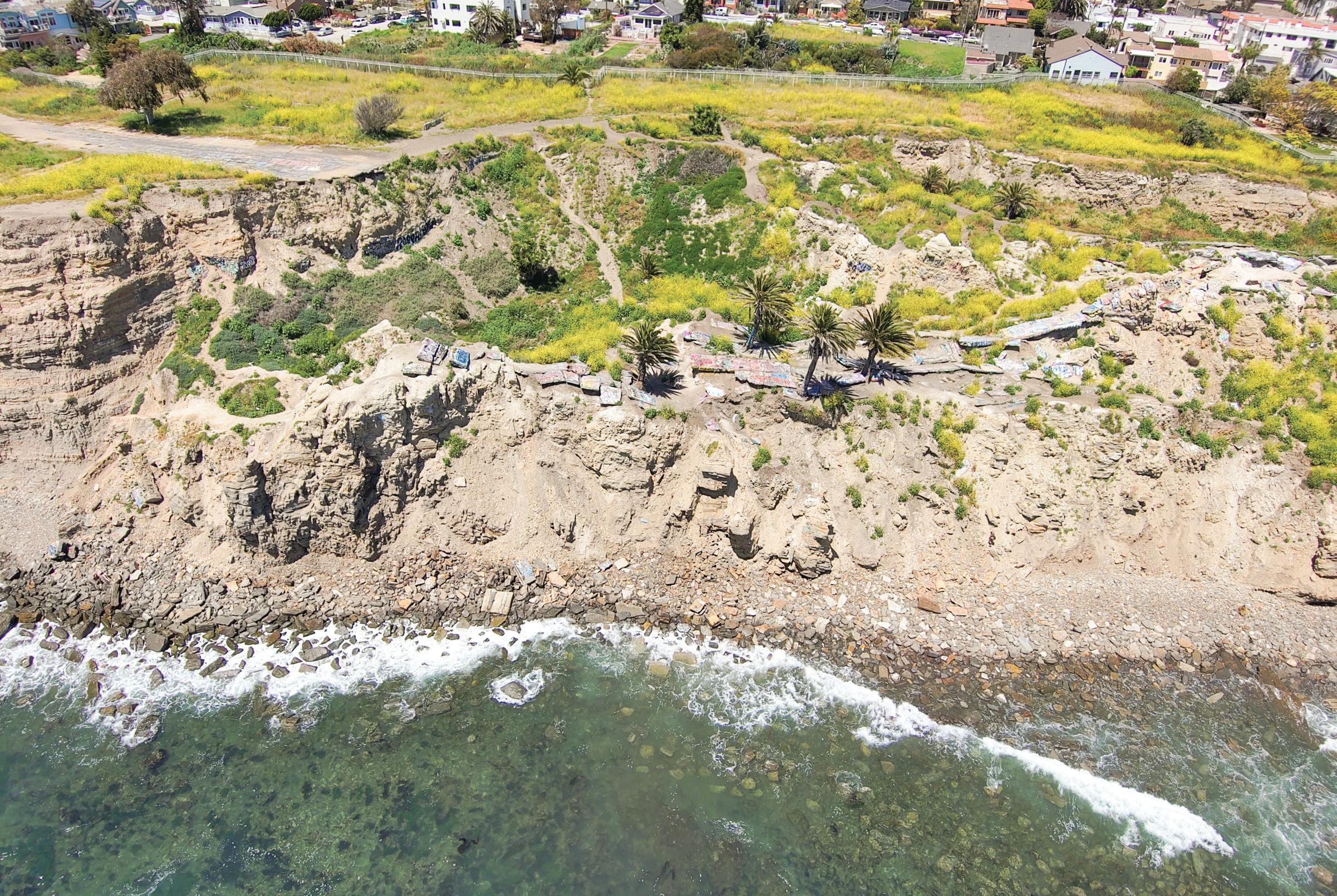
Today, Sunken City is known worldwide as an essential destination for graffiti writers. It’s a favorite spot for couples, people looking to get high and meditate on life, and teenagers too cool for school.

It endures as a warning to would-be developers who prioritize quick profits over long-term community.
On the inside of the barrier wall that people jump to enter Sunken City—between communities still intact and the desolation of a neighborhood that slid into the sea—a graffiti artist created a chubby blue water drop with mournful eyes.
As if warning us.
There are humans sounding warnings also.
“The cliffs have more time and more natural impetus to move,” DiFiori said.
She stands by beneath a sign at Bluff Cove that warns of falling rocks
“They’re not going to care how much money you spend to preserve structures,” she added. Mother nature has a bigger budget.”
Graffiti thrives amid ruins
By Ethan CohenAs he descends into the sunken abyss, he climbs over chunks of cracked street lanes and rocks.
He ascends to the top of a piece of road that is flat enough and looks into the distance seeing veering cliffs, sharp drops and loose dirt.
Determined, he keeps moving to find the next spot to put his mark on.
Rocks, chunks of road and even tree trunks are covered in thousands of rainbow-colored graffiti tags and murals.
Andrew, also known as Apple Jax or AJ, who declined to give his last name, is in the business of art.
Graphic design, clothing lines, brand deals and graffiti explicitly fall under his purview. And his main place of business: Sunken City, San Pedro.
“This spot is therapeutic for me,” AJ said. “But also, it’s a place for me to be able to grow my business.”
Fenced off and known as one of the greatest graffiti attractions for artists in the South Bay, Sunken City is
situated right next to the Point Fermin Lighthouse park.
However, it is also home to one of the most infamous geological disasters of the early twentieth century.
Sunken City is a beachfront area that was abandoned after a slow-moving landslide in 1929. Over the following decades, pieces of the coastline would slip into the ocean.
At one point, geologists measured the sinking of the coastline at an average of 11 inches per day.
The area was eventually fenced off and signs posted warning of fines after
complaints from the neighboring residents poured in about the loud music and roaring bonfires that occurred in the area.
That did not stop the art and artists from flowing into the landscape looking for an open canvas to create various pieces of art.
As AJ finally finds a place to make his canvas, he pulls out his cans and his friend sparks the tail end of a blunt.
“People come here for all the right reasons,” AJ said. “It’s a diverse place for people of all backgrounds to come together.”
Sunken City, San Pedro, is home to the sloped ruins of a century-old neighborhood that slowly fell into the sea. The coastline sloped at an average of 11 inches per day. Photo by Jay Seidel@itsecohen Cal Humanities June 1, 2023 SPECIAL SECTION B3
AJ creates a new peice centered around The Simpsons character Marge Simpson at Sunken City. Photo by Ethan Cohen

 Historical photos courtesy of City of Los Angeles Public Library, San Pedro Branch, Archives, Point Fermin Slide. Photos of Sunken City today by Kim McGill
Left, 1908, Point Fermin before development. Only the lighthouse exists. Below, 1940s, the paved street through the community ends abruptly where the neighborhood fell. Bottom, by 1950, the full impact was seen.
Historical photos courtesy of City of Los Angeles Public Library, San Pedro Branch, Archives, Point Fermin Slide. Photos of Sunken City today by Kim McGill
Left, 1908, Point Fermin before development. Only the lighthouse exists. Below, 1940s, the paved street through the community ends abruptly where the neighborhood fell. Bottom, by 1950, the full impact was seen.
SPECIAL SECTION B4 June 1, 2023 Cal Humanities This project was supported by California Humanities Emerging Journalist Fellowship Program. For more information, visit www.calhum.org. Any views or findings expressed in this publication do not necessarily represent those of California Humanities or the National Endowment for the Humanities.
Above left — Point Fermin community in the 1920s just before the landslide, or “slump,” began in 1929. The area that fell into the sea, now known as the Sunken City, is directly above the the Point Fermin lighthouse and park. The street and homes that fell are visible on the right along the edge of the cliff. The same street is above right after the landslide and below today.
Jessica Martinez Ethan Cohen Kim McGill Khoury Williams
Content by
Instructional Assistant