

INTRODUCTION
Buried Beneath the City is a special kind of book. It is a hybrid: an archaeology book about history and a history book about archaeology. It is a book about the place we call New York City, in all its diversity but also in its continuity over the past fourteen millennia. This history is seen through artifacts, the bits and pieces found in backyards, construction sites, street beds, and parks. It is a book meant to expand one’s understanding of the concepts and uses of archaeology, to increase one’s appreciation of the myriad ways of city life, past and present, to marvel that so much of the city’s material past has been saved, and to reflect on how much has been lost.
Archaeology is the study of material objects (artifacts) and their relationships to each other and to nonmaterial parts of culture. “Culture” in this sense is best thought of as information about the world and how to live in it. Artifacts are objects made, used, or modified by humans, whether in the past or present. They are the embodied material evidence of this cultural information; they indicate what their makers and users thought was important or proper or useful for life in the world as they saw it. Archaeologists also study features, which are large structures that cannot be moved, such as wells, house foundations, and even the heavily modified landscape of the city itself, since cities and their modified landscapes are artifacts of human creation as well.
Understanding the past, whether approached through archaeology or history, relies on our empathy and our imagination. Except for the limited span of our own lives, we were not witness to the events that eventually shaped our present. Our understanding of the past is filtered through someone else’s descriptions. This is not the same as being there or seeing it. Just as written records form the basic data of the historical record, artifacts and sites form the basic data of the archaeological record. Buried Beneath the City is about all of this.
The book is arranged chronologically. The chapters cover the period when Indigenous Peoples occupied the land by themselves, followed by European contact, then, in
turn, the Dutch city, the English city, the period following the Revolutionary War, and the later nineteenth century. It uses the collections of the New York City Archaeological Repository: The Nan A. Rothschild Research Center. Today New York City includes five boroughs: Manhattan, Brooklyn, Queens, Staten Island, and the Bronx. But before the incorporation of all the boroughs in 1898, New York City primarily meant Manhattan. Because many of the sites excavated in Manhattan yielded very large collections, most of the artifacts in the Repository come from Manhattan, and in some ways the Repository’s collections unintentionally emphasize that borough’s role in the city’s development (figure 0.1).
This island between the Hudson and East Rivers has seen geological and topographic changes over the past ten thousand years, as well as huge changes in the patterns of life and culture, including material culture, of its inhabitants. The shoreline has changed drastically, partly from natural causes like the rising sea levels from melting glaciers, and partly from human activity, like the landfilling that broadened the width of the island (figure 0.2). Hills were lowered, valleys filled, streams diverted, lakes and swamps drained. These changes can be traced both archaeologically and historically.1 While the history of the past four hundred years is richly documented, the archaeology of the ever-changing city and its peoples is less so. Even New Yorkers are often surprised that there is archaeology to be done in the city. Many assume either that there are no archaeological remains left in New York or that archaeology is concerned only with the period before Europeans came to this land.
The archaeological record complements the written history, which we call the documentary record. New York is rich in documentary sources: European colonial court and land records, diaries, travelogues, maps, paintings, and more. This gives us a precise view of how the tapestry of commerce, society, and politics developed, with all the threads of social, economic, and ethnic diversity that characterize it.2 New York City also has a wealth of landmarks that are designated for preservation by the New York City Landmarks Preservation Commission. They all provide information about the past— the Empire State Building in Midtown Manhattan, for instance, or the Fort Greene Historic District in Brooklyn. Designation recognizes the site’s importance, preserves it for later generations, and allows us to experience spaces that embody the past. Most of the city’s designated buildings and sites date from the nineteenth and twentieth centuries. But New York City’s archaeological resources help tell the stories that predate many of the city’s buildings. All of the New York City designated landmarks mentioned in this book are listed in appendix A.
There exists no documentary record before European contact. This is where archaeology comes in, as it can reveal the undocumented millennia when Indigenous Peoples inhabited this region. These traces and oral traditions are our only links to the most distant past, when there were no written records and no enduring standing structures.
2 INTRODUCTION
FIGURE 0.1
 The website of the NYC Archaeological Repository: The Nan A. Rothschild Research Center provides public access to the archaeological collections owned by the City of New York and excavated in the city’s five boroughs.
FIGURE 0.2
The Stadt Huys and 7 Hanover Square block highlighted on the James Lyne or Bradford Plan (top) and the Francis Maerschalck Plan (bottom) in 1728 and 1755. The distance of the 7 Hanover Square block from the waterfront illustrates the process of making land along the waterfront. Today, 7 Hanover Square is two full blocks from New York Harbor as opposed to what is shown on these eighteenth-century maps.

Maps courtesy of Norman B. Leventhal Map & Education Center of the Boston Public Library and the Library of Congress Map Division.

Artifacts and Documents
Artifacts have a life of their own. They are made, used, discarded, lost or buried, found or excavated, and sometimes curated. Each of these stages in the life of the artifact can tell us something about its past and its relation to people. There are artifacts illustrating religion (St. Catherine Labouré medal, figure 0.3), economics (merchant token, figure 0.4), social status (porcelain, figure 0.5), and recreation (bone die, figure 0.6); there are also features like the Battery, an eighteenth-century defensive fortification at the southern tip of Manhattan. While at times it may be difficult to draw out the information, it is there. And with it, we can reveal history and test the existing record. What more can be learned about the past through archaeology? Is not the history of New York completely documented in the written records? Why do urban archaeology at all? Archaeologists often use documents to frame questions that can only be answered by excavation and artifacts. While invaluable to history, documents such as historical maps, tax records, diaries, wills, and newspapers may include mistakes and biases. Remember, Columbus thought he had discovered India. Or documents may contain little or nothing on whole parts of the population, such as women, enslaved people, the sick, or the poor. Archaeologists realize that documents and maps have their own biases and must be read with a critical eye. Indeed, some maps and documents, in both the past and the present, have specifically and purposefully omitted documentation of such minorities as a means of majority control. Thus, without the artifacts, those people are denied their history. For example, excavation of enslaved people’s cabins at Thomas Jefferson’s home at Monticello in Virginia has helped to tell a fuller story of the lives of the enslaved people who lived there.3 Many times, documents simply omit the mundane aspects of day-to-day life, such as what people ate and when. Sometimes artifacts can correct misapprehensions. Beer bottles in a minister’s garbage may contradict our belief that he was a teetotaler. Although using historical documents is a necessary part of the research strategy of historical archaeology, it leaves gaps—especially gaps in the facts of everyday life—that can only be filled by artifacts and sites that take us much closer to historical reality. This is as true in cities as in caves, as true today as it was thousands of years ago, and as true in New York as it is in Cairo. Archaeologists dig in New York to retrieve these lost bits of information.
Since an artifact is the result of the rules generated by cultural information, the more we know about the context of the artifact, the more information we can infer from it. Single artifacts from unknown or undocumented locations are naturally less valuable to us than artifacts from well-documented excavations. An artifact found “in context” tells us exactly where it was found, what type of soil it was deposited within (figure 0.7), and what other artifacts or objects it was found alongside. In turn, comparing it to other artifacts from similar contexts lets the archaeologist determine its age or use or its relationships to historical people and events. But when an artifact’s context is unknown, meaning it has been taken from its original location without any information about where or how it was found, there is much less we can learn.
INTRODUCTION 5
FIGURE 0.3
Nineteenth-century Saint Catherine Labouré Miraculous Medal excavated from near Tweed Courthouse (a New York City landmark). The Catholic medal commemorates the appearance of the Virgin Mary to Catherine Labouré on November 27, 1830. The front (left), depicts the Virgin framed by the words “Ô Marie, conçue sans péché, priez pour nous qui avons recours à vous,” or “O Mary, conceived without sin, pray for us who have recourse to thee.” The reverse (right), has a circle of twelve stars, a letter M surmounted by a cross, the Sacred Heart of Jesus crowned with thorns, and Immaculate Heart of Mary pierced with a sword. Found during the Tweed Courthouse excavations.
Qi#3754 CHP (Qi# is the NYC Archaeological Repository catalog number.)
FIGURE 0.4
American one cent merchant token commissioned in 1794 by William Talbot, William Allum, and James Lee, partners in an East India trading company located at 241 Water Street in New York City. The token was redeemable for 1 cent worth of goods or tender “Payable at the Store of Talbot, Allum, & Lee,” as is stamped on one face of the token. The tokens served as a substitute for legal tender or currency, which was difficult to obtain in the new nation and fluctuated in value. This side depicts the standing image of liberty and reads “LIBERTY & COMMERCE.”

Qi#2386 CHP

FIGURE 0.5
Chinese export porcelain serving platter manufactured in China sometime between 1785 and 1853, found during excavations at Van Cortlandt House in the Bronx (a New York City landmark). The existence of costly Chinese porcelain, such as this piece known as Canton porcelain, tells us not only something about the economic status of the owner but also that the United States, as a newly formed country, had independently entered the global marketplace.

Qi#199138 VCP
FIGURE 0.6
Bone die excavated from Tweed Courthouse. The six-sided die is numbered 1 to 5 and one face, illustrated here, is curiously drilled with thirteen holes. A friendly game or high-stakes gambling, the die suggests many possibilities for eighteenthcentury gaming.
Qi# 3901 CHP

Many of the artifacts illustrated in Buried Beneath the City are from well-excavated contexts, sites like Seneca Village or the 7 Hanover Square Block (figures 0.7 and 0.8), where they have helped date and illuminate the activities of the inhabitants who lived centuries before us. Material recovered through archaeology can also tell us about the changing environment. For example, the shrinking size of oyster shells found in New York sites indicates progressive overharvesting as oysters were collected before they reached maturity. This practice correlates with the deterioration of the riverine and coastal environment because of sedimentation and pollution. All archaeological sites covered in this book are described in appendix B.
A Brief History of Archaeology in New York
Archaeologists have been digging in New York for more than a hundred years. Many of the early archaeological pioneers were avocational archaeologists rather than professionals. Archaeology as a profession did not emerge until the late nineteenth century. The collections of the Museum of the American Indian–Heye Foundation—now housed near the Battery in the former U.S. Customs House that became the National Museum of the American Indian—have their origin in these early excavations. The same is true for many of the collections curated by the American Museum of Natural History and the New-York Historical Society. These early excavation projects were almost always focused on Indigenous Peoples’ sites or sites associated with the American Revolutionary War. We discuss this early work in chapter 1, but it is worth noting that, although many of the practitioners were excellent fieldworkers, the ethical and culturally sensitive standards of today were not always evident in their excavations. Some of them used methodologies that would be considered inappropriate today, and some used methods that would have been considered inappropriate even at the time. Professional standards and practices, as well as the possibility of field training and advanced degrees, developed during the twentieth century.
By the 1970s, archaeology’s predominant practitioners were either university archaeologists or independent archaeological contractors working in response to the changing regulations governing construction firms or developers; this latter group were often called contract archaeologists. As the number of archaeologists working in the city grew, they gradually adopted the idea, first offered by NYU archaeologist Bert Salwen, that archaeologists should do “archaeology of the city, not only archaeology in the city.” 4 In other words, the city became the object of study, not just the place where the archaeologist dug. Soon, the periods of interest expanded from the area’s earliest habitation all the way to the nineteenth century. The city itself was the site, and its archaeological record an inseparable part of the study of its development (figure 0.8).
8 INTRODUCTION
FIGURE 0.7 Wall profile from 2011 Seneca Village excavation. Profiles are graphic representations of the vertical face of an excavation unit that show the stratigraphy and any features that have been uncovered. This profile illustrates the stratigraphic layers related to the creation of Central Park (layers SC 2 and SC 4A), co vering the foundations of the Charlotte and William Godfrey Wilson house (SC 6B and SC 6C). The artifacts found in the stratigraphic level SC 6B represent the artifacts the Wilson family left behind when relocating their home after being displaced through eminent domain for the construction of Central Park (a New York City landmark).
Profile rendering by Hunter Research, Inc.

FIGURE 0.8
The 7 Hanover Block (foreground) and the Stadt Huys block (top right) excavations, conducted between 1979 and 1981, were among the city’s first comprehensive large-scale excavations and provided access to three hundred years of city history. With Water Street to the left and Pearl Street to the right, the foundations of the eighteenth and nineteenth buildings that once fronted Pearl Street can be seen emerging from the ground.
7 Hanover Block Project, NYC Archaeological Repository.

Regulations and Archaeological Review
New York City has always experienced periods of intense development when the city seems to change overnight. One of these periods was in the mid-twentieth century when even Pennsylvania Station, a colossal train station modeled after the public buildings of Ancient Rome, was torn down after barely fifty years of service. In partial reaction to this destruction, Landmarks Law, Title 25, Chapter 3 of the New York City Administrative Code was enacted, establishing the New York City Landmarks Preservation Commission (see preface) charged with the designation and protection of the city’s historic sites. Other protections followed: federal (National Historic Preservation Act 1966, National Environmental Policy Act 1970), state (State of New York Environmental Quality Review Act 1975), and city (New York City Environmental Review Act 1977), all of which required that public projects and applications requiring discretionary government approval consider the impacts of their proposals on a range of resources, including “archaeological”. These acts, in effect, created the field of urban archaeology and the necessity of contract archaeology. The Landmarks Preservation Commission’s first archaeologist was hired in 1980, and its Archaeology Department was created in 2002. It remains one of the few such departments in the United States.5
The department reviews proposals submitted by other government agencies or developers subject to the regulations noted above. If it is deemed that the proposed construction may impact archaeological resources, the department then oversees the ensuing archaeology but does not undertake the work itself. LPC archaeologists regulate and set the guidelines and standards for archaeological work conducted in the city.6 One initial and notable result of this process was the excavation of the Lovelace Tavern (figure 0.9), on the Stadt Huys Block on Broad Street, one of the earliest taverns in New York. It was even used temporarily as City Hall, and its excavation illuminated a poorly documented slice of life of the seventeenth-century Dutch and English city.
Archaeological Process in New York City Under Landmarks Preservation Commission Oversight
1. Archaeological Documentary Study: Once a potential site is identified by LPC, a study is completed by a consulting archaeologist of all relevant historical documents, including previous archaeological reports, tax documents, wills and property records, and maps. A study such as this determines whether significant archaeological resources may exist at the site. The information produced is collected in a report that describes the analysis and its findings. Significant resources are those that can reveal new information about the past.
2. Archaeological Testing: If the previous step indicated that the site may have significant archaeological resources, the next step is to sample the site. This may mean borings, hand-excavated trenches, mechanical excavation, deep testing, or
INTRODUCTION 11
FIGURE 0.9
Overview of northeast corner of the Lovelace Tavern foundation, which lies under a wall from a nineteenthcentury building. Found during the Stadt Huys Excavations conducted from 1979 to 1980.
The Stadt Huys Block Project, NYC Archaeological Repository.

whatever appropriate technique can determine the presence and integrity of archaeological resources at a site. This multistep process includes a scope of work, the field testing itself, an analysis of what was found, and preparation of a final report by a consulting archaeologist or cultural resource management firm.
3. Archaeological Excavation: If the testing has determined that a site has potentially significant resources, often the project is redesigned to preserve the archaeological resources in place. If that is not possible, then it is essential that the site’s archaeological information be preserved, which is best achieved by an archaeological excavation involving the scientific removal of earth in archaeologically sensitive areas by an archaeological team. This multistep process includes a scope of work, the excavation work, the analysis of what was found, and the creation of a final report and curation plan.
4. Curation Plan: If significant archaeological artifacts are recovered, they must be appropriately curated in archaeological repositories so that they are available for further study and exhibition. It is also important that project records be appropriately archived as they are essential when examining or reexamining archaeological material from a site.
Archaeological Technology
What are the tools of the modern urban archaeologist? Simply looking at the archive of New York City’s archaeological reports shows how archaeological methodology in the city has developed over the past four decades. Computers, and especially laptops, have transformed documentation and recording. New standard forms have arisen for artifacts, contexts, and excavation units, which ensure that proper uniform measurements and other data are taken in the field and allows us to compare data sets among different excavations. A few online national archaeological databases have been created for archaeologists to share and record their findings. We have new technologies such as ground-penetrating radar (GPR), which can investigate objects and structures beneath the ground without ever breaking the surface, like an X-ray for the earth (figure 0.10). We now use dendrochronology (tree-ring dating) on the principle that matching the pattern of thick and thin rings within a tree (which correlates to the rainfall in a given year) to those of other trees of known age will allow us to determine construction dates of Colonial structures and landfill, such as those found in Battery Park. Total station electronic (laser) theodolites automate surveying and map making. Geographic information system (GIS) programs, using precise information from satellites, give the archaeologist precision in identifying locations and has simplified the process of drawing overlay maps to show changes in the use of a site or
INTRODUCTION 13
FIGURE 0.10
that was recorded using radar pulses and combined
create a
Historical records indicate that this site contained an enslaved African burial ground adjacent to the one pictured here for enslaver families, which was verified using GPR technology.
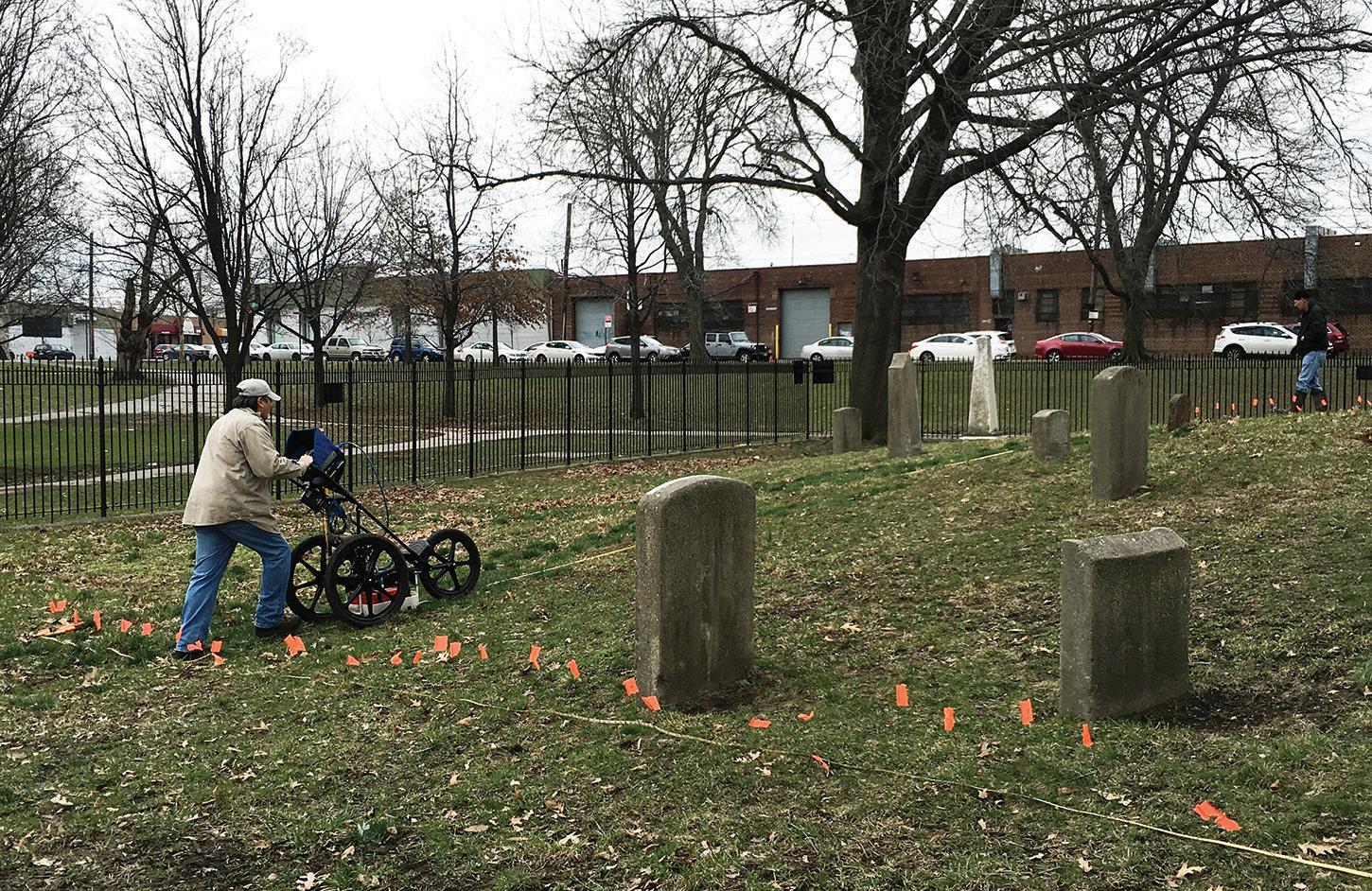
Photograph by Jessica S. MacLean, 2016.
a part of the city through time. Historic maps online can be georeferenced to show the landfilling that created new land for wharfs and structures in the early nineteenth century, which have been excavated in Lower Manhattan (Battery Park). We will see this array of archaeological technology throughout the book.
The analysis of artifacts once they have been excavated has also changed dramatically. More collections and museums are digitizing their repositories with online photos and illustrations, and this has encouraged faster and more precise identification of artifacts. This can help establish dates, origins, and often producers of artifacts such as pottery and clay pipes. Archaeologists can also better trace the paths and growth of New York commerce through mass-produced items such as sugar molds and oyster jars. Preferences in types of cookware can indicate possible ethnic differences even within the same block or tenement. Identification of artifacts through association with other known artifacts elsewhere can lead to the attribution of this context to a specific profession, such as doctor or artist. Artifactual data can correct impressions erroneously found in texts, as in the newspaper accounts that claimed Seneca Village was a deeply impoverished community.
New techniques of analysis are also providing significant information. Portable and readily available X-ray fluorescent (XRF) spectrometers allow archaeologists to compare the elemental composition of similar or identical artifacts in the field and in the lab, thus giving another glimpse into their origin and trade patterns. This technique
14 INTRODUCTION
A ground-penetrating radar (GPR) survey being conducted at Drake Park in Hunts Point in the Bronx to identify and delineate burials located underground without excavation. Each orange flag marks a transect, or slice,
to
complete map of the subsurface.
shoots a beam of charged particles into a sample—a pottery piece, for example—and produces a readout of the elements it contains and their percentages, which can be extremely helpful when it is difficult to tell whether, for example, a piece of stoneware pottery was imported from Germany or locally made.
All of these developments have made archaeology more useful in documenting New York’s past. But even earlier projects with simpler technologies have added to the rich archaeological picture of this city.
Overview, Buried Beneath the City
Over the past hundred years, archaeologists have unearthed all sorts of sites in New York City, from places that were used for thousands of years before the city emerged to residential and commercial sites of the past few centuries. They have unearthed Colonial fortifications, buried ships, and burial grounds. Some archaeological projects were granted a single opportunity, over a given amount of time, to excavate before the site was developed, potentially sealing the ground below it forever. And some areas, such as City Hall Park, have been excavated several times—each excavation turning up new artifacts and new information about the lives of the past.
The artifacts in this book tell the stories of life in New York in different times. They help us understand the lives of ancient paleolithic hunters and Woodland-era Indigenous Peoples who fished, gathered shellfish, and farmed. Through artifacts and archaeology, we can see their environment and how they used the land and its natural resources before the city emerged. Archaeology also shows us Dutch life during the settlement of New Amsterdam and English life when it became New York for the first time. We can see the growing diversity of the city in the artifacts, which themselves also illustrate the meaning and utility of the concept of ethnicity. Some colonists saw themselves as English, some as Dutch, and some as something different. Enslaved people, coming from different regions in Africa and forced into differing cultures in the New World, were as diverse as the colonists. Even the post-Revolutionary period brought an influx of immigrants from within and outside the country, and new canals tied the rapidly growing city more firmly to the economic and social lives of the American heartland. Population density and diversity increased alongside each other. New York never had a homogeneous population. Rich and poor, merchants and laborers, Dutch, English, Indigenous Peoples, enslaved and free Africans, people of ethnic groups from around the world had to, live, die, work, and play together in New York, whether they liked it or not.
The lives of the people who lived in New York are written into these artifacts and, along with them, the particularly urban problems of disease, clean water, keeping law and order among an ever increasing and diverse population, disastrous fires, and the raising and educating of children. All of these can be found in the stories told by the artifacts from every period of New York’s history. We hope this book helps you hear them.
INTRODUCTION 15
1 2 3 4 5 7 10 11 12 13 14 6 NEW JERSEY NEW YORK STATEN ISLAND BROOKLYN QUEENS BRONX MANHATTAN Upper New York Bay Hudson River Long Island Sound Jamaica Bay Lower New York Bay ATLANTIC OCEAN 9 8 EastRiver 1. 2. 3. 4. 5. 6. 7. 8. Riverdale Archaeological Research Project, Bronx Pelham Bay Park, Bronx Tubby Hook, Manhattan Inwood Hill Park, Manhattan Throgs Neck, Bronx College Point, Queens Bay Terrace, Queens South Ferry Terminal Project, Manhattan 9. 10. 11. 12. 13. 14. Stadt Huys, Manhattan Old Place Neck, Staten Island Richmond Hill, Staten Island Port Mobil, Staten Island Aakawaxung Munahanung (Island Protected from the Wind) Archaeological Site, Staten Island H.F. Hollowell Site, Staten Island LOWER MANHATTAN 0.25 mi 0 5 mi 02.5 N
Everyday objects from archaeological excavations provide glimpses into New York City’s forgotten history beginning more than ten thousand years ago. They illuminate Indigenous societies, Dutch and English colonialism, and the city’s transformation into a modern metropolis. Using artifacts from the NYC Archaeological Repository, this book offers insights into the lives of the many people who were here before us.
“What a fascinating and inspiring book! Exploring thousands of years of New York City’s ecological, material, and social history, Buried Beneath the City shows us not only what we can learn from the material leavings of the past but also how archaeologists work to make sense of this evidence.”
Elizabeth Blackmar, coauthor of The Park and the People: A History of Central Park
“This beautiful book demonstrates how much is available to recover from beneath our feet in New York City. The authors guide us sure-handedly through the pre-twentiethcentury collision of cultures that still affects our world today.”
— Leslie M. Harris, author of In the Shadow of Slavery: African Americans in New York City, 1626–1863
“Buried Beneath the City unearths a new vista, the remains of the days before Europeans arrived and of lost quotidian life since. Take a revealing, self-guided underground expedition through material evidence that sheds light on the periods and people neglected by the documentary record.”

Sam Roberts, author of A History of New York in 101 Objects
Nan A. Rothschild is an urban social archaeologist who was Ann Whitney Olin Professor of Anthropology at Barnard College and is adjunct professor at Columbia University.
Amanda Sutphin is the director of archaeology at the New York City Landmarks Preservation Commission and manages the NYC Archaeological Repository: The Nan A. Rothschild Research Center.
H. Arthur Bankoff is the advisor to the chair for archaeology at the New York City Landmarks Preservation Commission and is a professor emeritus in the Department of Anthropology at Brooklyn College, City University of New York.
Jessica Striebel MacLean is an urban archaeologist at the New York City Landmarks Preservation Commission and the NYC Archaeological Repository.
The Landmarks Preservation Commission is the largest municipal preservation agency in the United States. It is responsible for protecting New York City’s architecturally, historically, and culturally significant buildings and sites by granting them landmark or historic district status and regulating them after designation.
PRINTED IN THE U.S.A. COLUMBIA UNIVERSITY PRESS NEW YORK cup.columbia.edu Cover illustration: James Gulliver Hancock