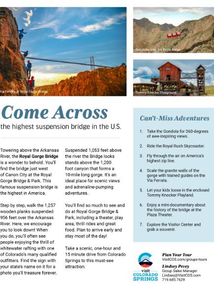
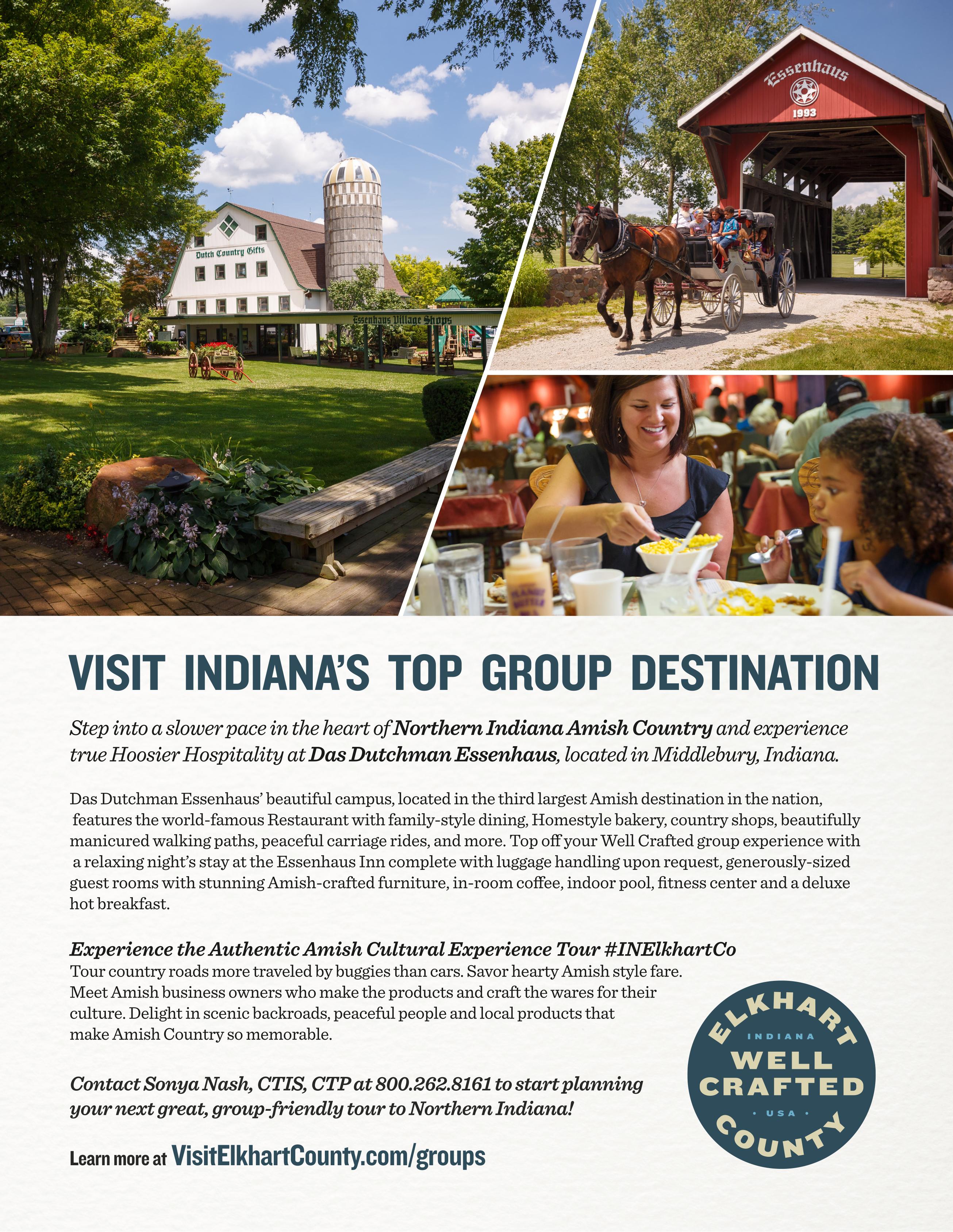
Preview
ByStephenKirchner,Editor&Publisher

GavinsPointDamcreatesLewisandClarkLake,a popularregionaltouristdestinationforwater-based recreationalopportunitiesincludingboatingand fishing,alongwithcamping,hiking,hunting,bird watching,swimming,bikingandandphotography.
Whenitopenedin1964,theVerrazano-Narrows BridgeinNewYorkwastheworld’slongest suspensionspan.Fiftyyearslateritisstillthelongest suspensionbridgeintheUnitedStates.
LocatedatthemouthofupperNewYorkBay,the bridgenotonlyconnectsBrooklynwithStaten Island,butisalsoamajor linkintheinterstate highwaysystem,providing theshortestroutebetween theMiddleAtlanticstates andLongIsland.

Thedouble-deckbridge carries13lanesofInterstate 278,withsevenlanesonthe upperlevelandsixonthe lowerlevel.
Inhiscolumn,BillGraves admitsheneverknewabout theColoradoRiver.TheoneinTexas,thatis.And you’llbeforgivenifyoudidn’tknowaboutiteither. TheTexasColoradoRiverrisesinthenorthwestern partofthestate,neartheNewMexicoline,andflows 894milestotheGulfofMexico.TheTexas Coloradoisrestrainedwithaseriesofsixdams.With thecompletionofthefirstonein1939,thetwo-mile longBuchananDam,thishillcountryareaofcentral Texastookonneweconomiclife.
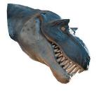
50,000yearsagoanironasteroidsmashedintoNorth Americaandleftagapingholeinwhatistoday northernArizona.In What’sHappening,wediscover MeteorCraterisafamoustouristattractionwitha museumfeaturingdisplaysaboutthehistoryofthe craterandasteroidimpactscience.
WehopeyouenjoythisissueofByways.
Byways4


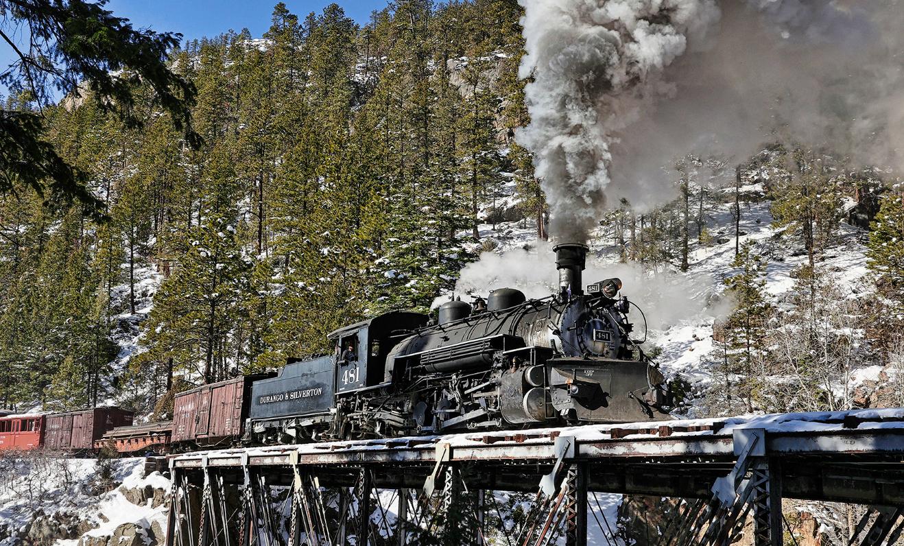
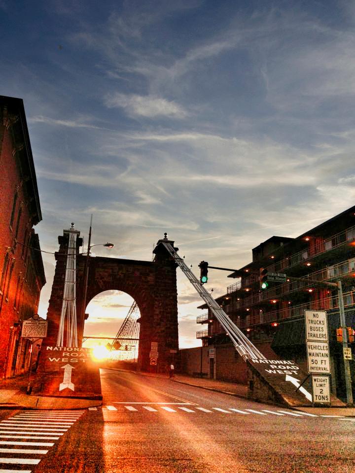
Byways7 Volume39,IssueNo.62022 Features Departments CominginFutureIssues BywaysInstantConnect........................................................................................................................3 BywaysPreview....................................................................................................................................4 TravelingtheHighways&BywayswithBillGraves.............................................................................34 Advertiser/SponsoredContentIndex..................................................................................................54 What’sHappening OntheCover. ThearchedentrywaytothehistoricWheelingSuspension Bridge.Itwasthelargestsuspensionbridgeintheworldfrom1849until 1851.PhotocourtesyJeremyMorrisand VisitWheelingWV.Formoreon Dams&Bridges,turntopage12. UpNext:GreatAmerican Railroads FutureissuesofBywayswillfeatureGreatAmericanRailroads,Mountains&Valleysandmore.... Colorado’sDurangoandSilverton NarrowGaugeRailroadisa3ft narrow-gaugeheritagerailroadthat operateson45.2milesoftrack betweenDurangoandSilverton. Therailwayisafederally-designated NationalHistoricLandmark.Photo courtesyDr.JohnA.Kirchner. Arizona’sMeteorCrater.......................................................................................................................50 Wheeling’sHistoricSuspensionBridge...............................................................................................14 California’sFamousBixbyBridge........................................................................................................20 Chicago’sRiverwalkBridges...............................................................................................................26 GavinsPointDam&Lewis&ClarkLake............................................................................................38 TheVerrazano-NarrowsBridge...........................................................................................................44
Byways8
Byways9
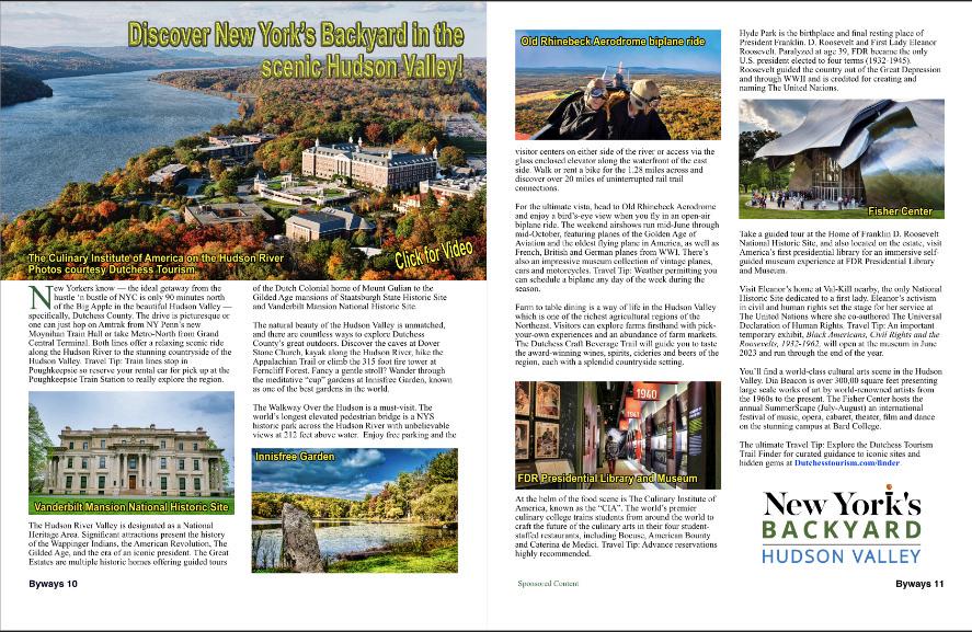
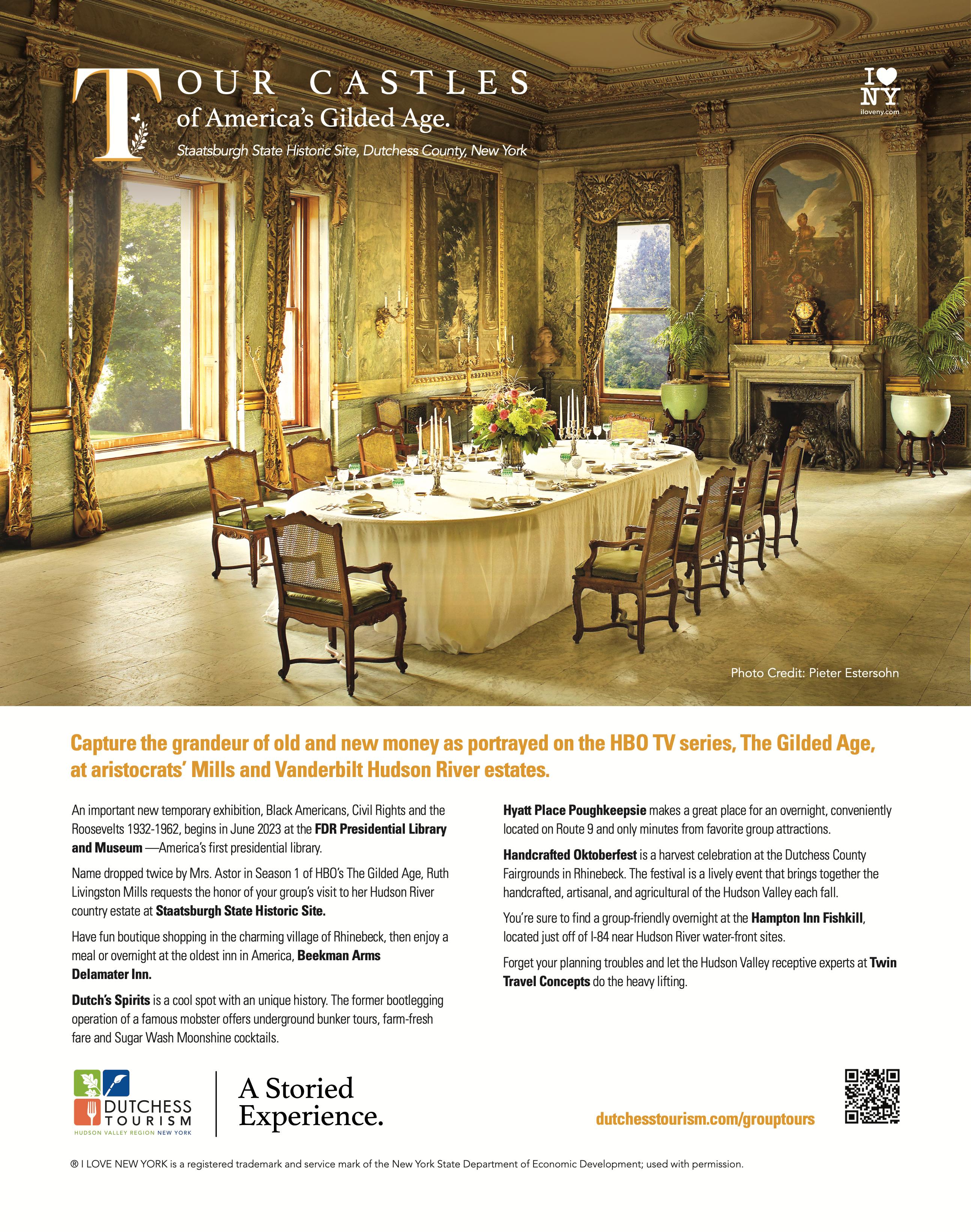
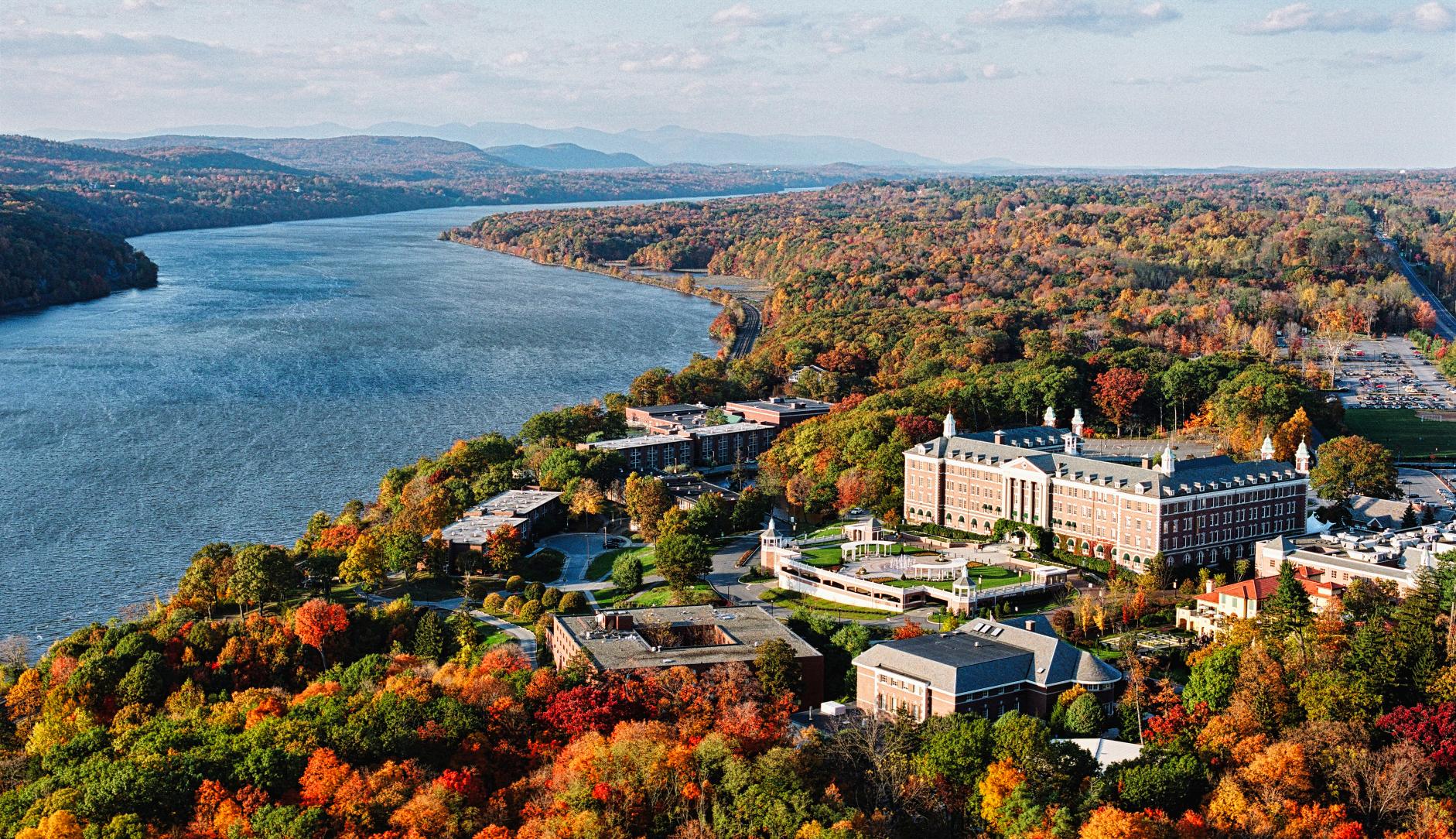
NewYorkersknow—theidealgetawayfromthe hustle‘nbustleofNYCisonly90minutesnorth oftheBigAppleinthebeautifulHudsonValley— specifically,DutchessCounty.Thedriveispicturesqueor onecanjusthoponAmtrakfromNYPenn’snew MoynihanTrainHallortakeMetro-NorthfromGrand CentralTerminal.Bothlinesofferarelaxingscenicride alongtheHudsonRivertothestunningcountrysideofthe HudsonValley.TravelTip:Trainlinesstopin Poughkeepsiesoreserveyourrentalcarforpickupatthe PoughkeepsieTrainStationtoreallyexploretheregion.

ThenaturalbeautyoftheHudsonValleyisunmatched, andtherearecountlesswaystoexploreDutchess County’sgreatoutdoors.DiscoverthecavesatDover StoneChurch,kayakalongtheHudsonRiver,hikethe AppalachianTrailorclimbthe315footfiretowerat FerncliffForest.Fancyagentlestroll?Wanderthrough themeditative“cup”gardensatInnisfreeGarden,known asoneofthebestgardensintheworld.
TheWalkwayOvertheHudsonisamust-visit.The world’slongestelevatedpedestrianbridgeisaNYS historicparkacrosstheHudsonRiverwithunbelievable viewsat212feetabovewater.Enjoyfreeparkingandthe

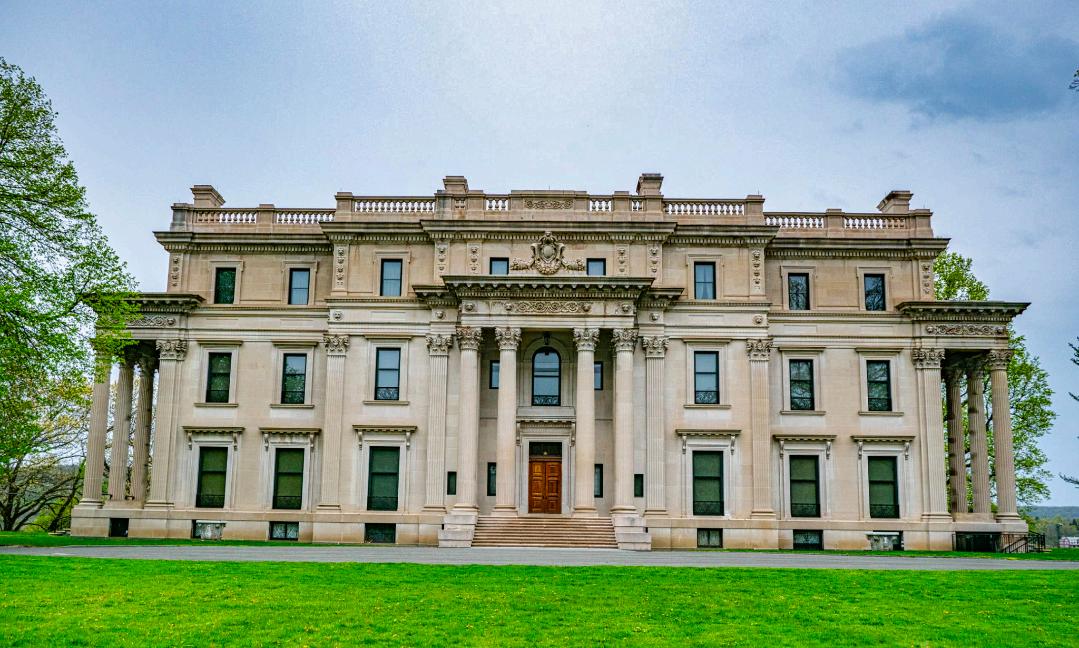
TheHudsonRiverValleyisdesignatedasaNational HeritageArea.Significantattractionspresentthehistory oftheWappingerIndians,theAmericanRevolution,The GildedAge,andtheeraofaniconicpresident.TheGreat Estatesaremultiplehistorichomesofferingguidedtours
Byways10
oftheDutchColonialhomeofMountGuliantothe GildedAgemansionsofStaatsburghStateHistoricSite andVanderbiltMansionNationalHistoricSite.
visitorcentersoneithersideoftheriveroraccessviathe glassenclosedelevatoralongthewaterfrontoftheeast side.Walkorrentabikeforthe1.28milesacrossand discoverover20milesofuninterruptedrailtrail connections.
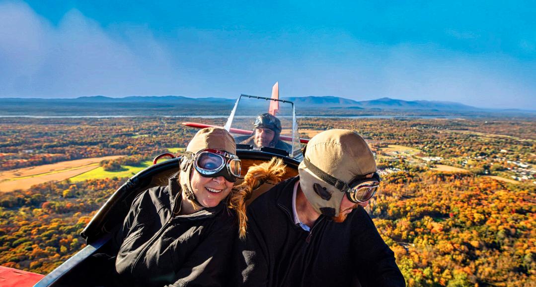
Fortheultimatevista,headtoOldRhinebeckAerodrome andenjoyabird’s-eyeviewwhenyouflyinanopen-air biplaneride.Theweekendairshowsrunmid-Junethrough mid-October,featuringplanesoftheGoldenAgeof AviationandtheoldestflyingplaneinAmerica,aswellas French,BritishandGermanplanesfromWWI.There’s alsoanimpressivemuseumcollectionofvintageplanes, carsandmotorcycles.TravelTip:Weatherpermittingyou canscheduleabiplaneanydayoftheweekduringthe season.
FarmtotablediningisawayoflifeintheHudsonValley whichisoneoftherichestagriculturalregionsofthe Northeast.Visitorscanexplorefarmsfirsthandwithpickyour-ownexperiencesandanabundanceoffarmmarkets. TheDutchessCraftBeverageTrailwillguideyoutotaste theaward-winningwines,spirits,cideriesandbeersofthe region,eachwithasplendidcountrysidesetting.
HydeParkisthebirthplaceandfinalrestingplaceof PresidentFranklin.D.RooseveltandFirstLadyEleanor Roosevelt.Paralyzedatage39,FDRbecametheonly U.S.presidentelectedtofourterms(1932-1945). RooseveltguidedthecountryoutoftheGreatDepression andthroughWWIIandiscreditedforcreatingand namingTheUnitedNations.
TakeaguidedtourattheHomeofFranklinD.Roosevelt NationalHistoricSite,andalsolocatedontheestate,visit America’sfirstpresidentiallibraryforanimmersiveselfguidedmuseumexperienceatFDRPresidentialLibrary andMuseum.
VisitEleanor’shomeatVal-Killnearby,theonlyNational HistoricSitededicatedtoafirstlady.Eleanor’sactivism incivilandhumanrightssetthestageforherserviceat TheUnitedNationswheresheco-authoredTheUniversal DeclarationofHumanRights.TravelTip:Animportant temporaryexhibit, BlackAmericans, CivilRightsandthe Roosevelts,1932-1962, willopenatthemuseuminJune 2023andrunthroughtheendoftheyear.
You’llfindaworld-classculturalartssceneintheHudson Valley.DiaBeaconisover300,00squarefeetpresenting largescaleworksofartbyworld-renownedartistsfrom the1960stothepresent.TheFisherCenterhoststhe annualSummerScape(July-August)aninternational festivalofmusic,opera,cabaret,theater,filmanddance onthestunningcampusatBardCollege.

TheultimateTravelTip:ExploretheDutchessTourism TrailFinderforcuratedguidancetoiconicsitesand hiddengemsat Dutchesstourism.com/finder.
AtthehelmofthefoodsceneisTheCulinaryInstituteof America,knownasthe“CIA”.Theworld’spremier culinarycollegetrainsstudentsfromaroundtheworldto craftthefutureoftheculinaryartsintheirfourstudentstaffedrestaurants,includingBocuse,AmericanBounty andCaterinadeMedici.TravelTip:Advancereservations highlyrecommended.
Byways11
SponsoredContent

Byways12
Byways13


Byways14


Byways15
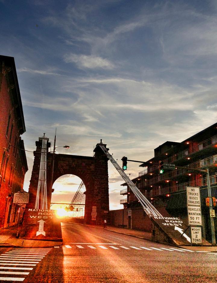
SetontheOhioRiverinthefoothillsofthe AppalachianMountains,Wheelingisahistoric place:It’sWestVirginia’sfirststatecapital,the placewherethestatebecameastate,hometobattle sitesandburialmounds...thelistislengthy.
Residentstakeprideinthathistory,restoringand repurposingbuildingsandmaintainingasenseof traditionevenastheylooktothefuture.Oncean industrialepicenter,Wheelingisresponsiblefor givingtheUSAmanyofitsmostusefulproducts, fromcutnailstooveralls.Explorethathistoryat

Byways16
landmarksites. AStepBackinHistory
museums,marketplaces,bed-and-breakfastinnsand
LooktotheWheelingSuspensionBridge,builtin 1849,totransportyoubacktothecity’spast.This NationalHeritageAreaincludesWestVirginia IndependenceHall,whereyoucantakeaself-guided tour.VisittheMuseumsofOglebayInstitutetolearn aboutAmericandecorativeartsandWheeling’spast. TourVictorianOldTown’sEckhartHouse,which
offersatraditionalteaservice.AtGraveCreek Mound,seeoneofthelargestAdenaburialmounds. Whilethere,stepinsidetheDelfNoronaMuseum andlearnaboutthehistorianwhocreatedit.
ThehistoricWheelingSuspensionBridgecarriesthe NationalRoadovertheOhioRiverbetween WheelingIslandanddowntownWheeling,West Virginia.ItwasthefirstbridgetospantheOhio Riverandthelargestsuspensionbridgeintheworld from1849until1851.

History
AcharterwasgrantedtotheWheeling&Belmont BridgeCompanytoconstructabridgeoverthemain channeloftheOhioRivertoextendtheNational Road(alsoknownastheCumberlandPikebecauseit beganinCumberland,Maryland)acrosstheOhio River.ItwouldextendtheNationalRoadintoOhio, whichhadreachedWheelingonAugust1,1818. However,ferriesthentookpassengersandfreightto
theotheroftherivertocontinueontheNational Road.
Atthetime,bothWheelingandPittsburghcompeted tobecomecommercialhubs,connectingtheEastern SeaboardwiththeMidwestacrossthecentral AppalachianMountains.In1820,Congress authorizedtheNationalRoad’sextensiontoSt. Louis,Missouri.
VirginiaandOhiojointlyissuedthenewWheeling bridgecharter.CharlesEllettJr.andJohnA. Roeblingwereinvitedtosubmitdesignsand estimatesforasuspensionbridgeoverthemain channeloftheOhioRiver.Bothweretheforemost authorityonbridgesofthatcrossingtype.
Ellettwasawardeda$120,000contracttobuildthe bridgein1847,beatingoutRoebling’sbidfora shorterdouble-spancrossingthatwasestimatedto cost$130,000.
Byways17
TheWheelingSuspensionBridgewascompletedin November1849atthecostof$250,000.Itfeatureda simpletimberdeckthatrestedontransversetimber floorbeams,whichweresupportedattheirendsby
wroughtironsuspendershungfrommaincables.It wasthefirstmajorsuspensionbridgeintheUnited StatesandallowedfortheNationalRoadtobe connectedbyafixedcrossing.

Byways18
TheWheelingBridgelinkedtheeasternandwestern sectionoftheNationalRoad,andbecameespecially strategicallyimportantduringtheAmericanCivil War.LitigationintheUnitedStatesSupremeCourt
concerningitsobstructionofthenewhigh steamboatsmokestackseventuallyclearedthe wayforotherbridges,especiallyneededby expandingrailroads.Becausethisbridgewas designedduringthehorse-and-buggyera,2tonweightlimitsandvehicleseparation requirementsappliedinlateryearsuntilitwas closedtoautomobiletrafficinSeptember 2019.
Thesuspensionbridgewassubjectedto torsionalandverticalmovementsthatcaused theflooringtobetossedtotheheightofthe towersandresultedinthecollapseofthe crossingonMay17,1854.
Apermanentsuspensionbridge,withthesame designastheoriginal,openedin1859.

WilliamHildenbrandmodifiedthespanbased upondesignsbyWashingtonA.Roeblingin 1871-72byaddingauxiliarystaycablesand replacingthedecktoaddstrengthand resistanceagainststrongwinds.Other improvementsdesignedbyHildenbrandwere madein1886,andotherrepairswerecarried outin1922and1930.
AtthetimeoftheWheelingSuspension Bridge’sconstruction,ahorseandbuggywere theheaviestliveloadthatwouldbeexpected. A4,000-poundweightlimitwaslaterplaced uponthebridge,whichmadeitunsuitablefor trucks,buses,orotherheavyvehicles.
Themainspanis1,010feetfromtowerto tower.TheeasttowerrestsontheWheeling shore,whilethewesttowerisonWheeling Island.Theeasttoweris153.5feetabovethe low-waterleveloftheriver,or82feetfrom thebaseofthemasonry.Thewesttoweris 132.75feetabovelowwater,with69feetof masonry.
ThecrossingwashonoredasaNational HistoricCivilEngineeringLandmarkin1969 andwaslistedasaNationalHistoric Landmark,thehighesthonorthatcouldbe bestowedonanon-federalsiteorstructure,in 1975.ItwasthenlistedontheNational RegisterofHistoricPlacesin1980.
https://wheelingcvb.com t
Byways19


Byways20


Byways21
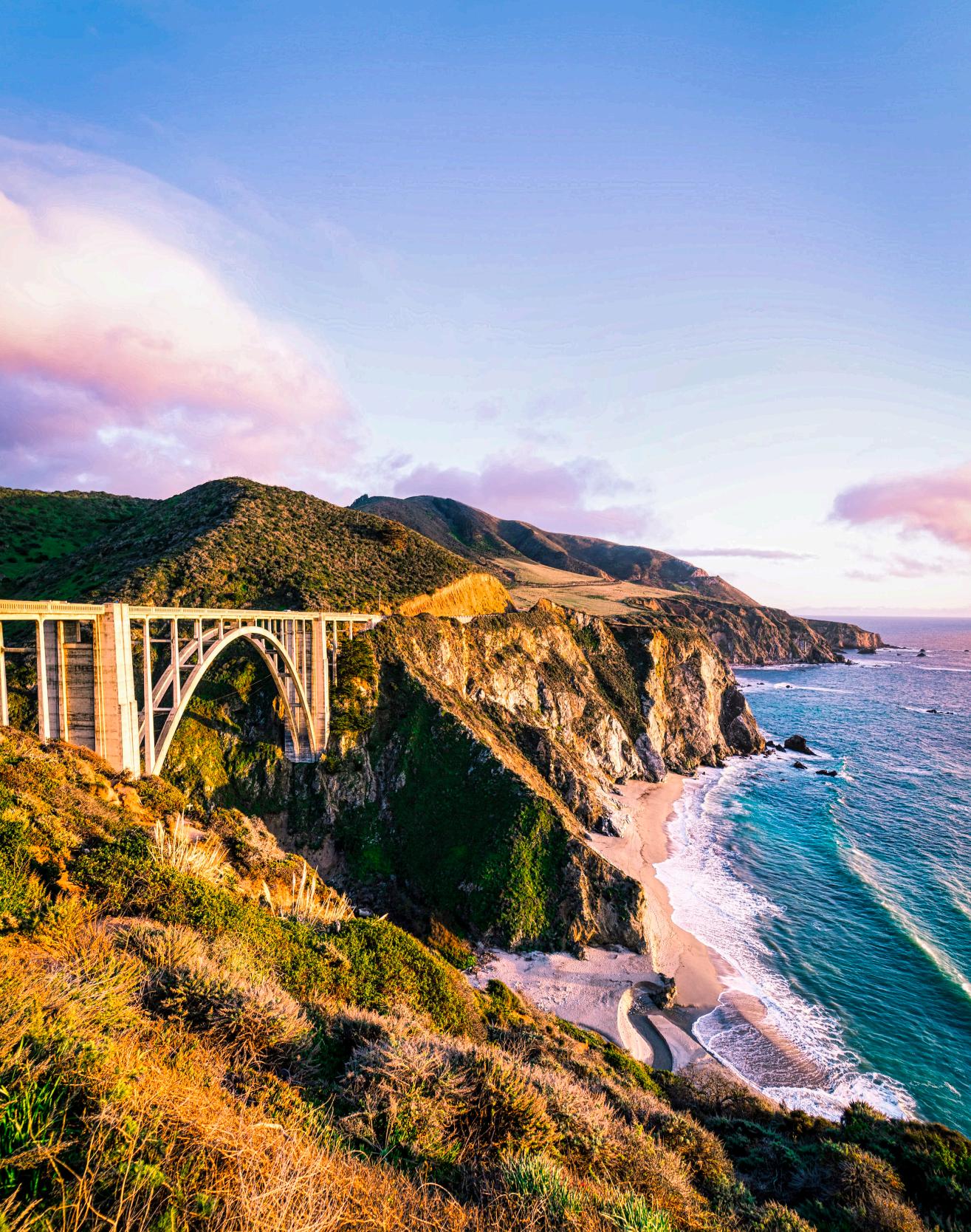
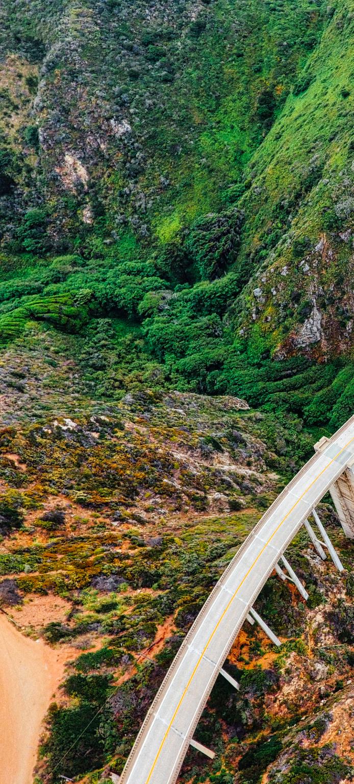
WelcometoBigSur’sversionoftheGolden Gate,amust-seeroadtripspotfor manyandprobablythemostInstagrammed featurealongtheHighway1coastline.
Completedin1932forjustover$200,000,the concretespan,oneofthehighestbridgesofitskind intheworld,soars260feetabovethebottomofa steepcanyoncarvedbyBixbyCreek.
TheBixbyBridgeisoneofthemostphotographed bridgesinCaliforniaduetoitsaestheticdesign, “gracefularchitectureandmagnificentsetting”.Itisa reinforcedconcreteopen-spandrelarchbridge.The bridgeis120milessouthofSanFrancisco.
Thebridgeisapproximately18milessouthof MontereyandCarmel-by-the-Sea.Enjoythe incredibleviewsofBigSur’srockycoastline.The iconiccementarchhasalsobeenfeaturedon postcards,musicvideosandanarrayofTVspots includingcarcommercialsandthehitHBOseries BigLittleLies
EpicphotoopsoftheBixbyBridgeandtheBigSur coastlineawait!HurricanePoint,justsouthofthe bridge,offersclearviewstothenorth,southand west.Becauseofthiswide-openarea,itisvery windy,hencethename“HurricanePoint”.

Byways22
History
Over300,000boardfeetofDouglasfirtimber,used tobuilda250-foothighfalseworktosupportthearch duringconstruction,wastransportedfromthe railroadterminalinMontereyoverthenarrow,onewayroadtothebridgesite.Itwasdifficulttoraise, becauseitwasconstantlyexposedtohighwinds. Someofthefalseworktimberswere10by10inches. Ittooktwomonthstoconstructthefalseworkalone. Whenhighwavesthreatenedthefalsework foundation,constructionwashaltedforashorttime untilwinterstormsabated.
ThebridgewascompletedonOctober15,1932, althoughthehighwaywasnotfinishedforanother
fiveyears.Atitscompletion,thebridgecost $199,861and,at360feet,wasthelongestconcrete archspanontheCaliforniaStateHighwaySystem. Thebridgewasnecessarytocompletethetwo-lane roadwhichopenedin1937after18yearsof construction.

Thebridgewasretrofittedbeginningin1996aspart oftheCaltransPhaseIIseismicretrofitprogram.In theirdetailedevaluationofthebridge’sseismic vulnerabilities,theywerechallengedtofinda solutionthatmetseveraldifficultissues,including severeloadfactors,extremelylimitedphysical access,maintainingtheappearanceoftheexisting historicalstructure,andarequirementbytheStateof

Byways23
Californiathatatleastonelaneofthebridgeremain openatalltimes.
ScenicBeauty
Thebridgecontributestothescenicattractionof drivingHighway1.The72-milesectionofthe highwayfromCambriatoCarmelHighlandswasthe firstinthestatetobedesignatedasaScenicHighway in1965.In1966FirstLadyLadyBirdJohnsonled theofficialscenicroaddesignationceremonyat BixbyCreekBridge.

Thebridgewasalreadypopularbeforethe introductionofsmartphonesandsocialmedia,and visitorstotheBixbyCreekBridgeandotherBigSur attractionshavedramaticallyincreasedsincethen. Duetothelargenumberofvisitors,congestionand slowtrafficbetweenCarmelandthebridgeis frequentlythenormduringpopularholidayand vacationperiods.
https://www.bigsurcalifornia.org
Byways24


Byways25


Byways26


Byways27
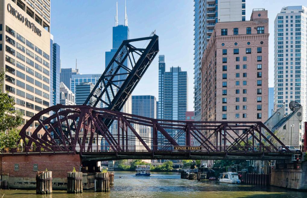
Chicagoisnotjusthometomanyoftheworld’s earliestskyscrapers,itisalsoacityofbridges. NexttimeyoucrosstheriveralongMichiganAvenue, StateStreet,WellsStreetorWabashAvenue,look down.You’rewalkingononeoffivedifferenttypesof movablebridgesfoundinChicago.There’satotalof 37movablebridgeswithinthecitylimits.
TheChicagoRiverisasystemofriversandcanals withacombinedlengthof156milesthatrunsthrough thecityofChicago,includingitscenter,theChicago Loop.Thoughnotespeciallylong,theriverisnotable becauseitisoneofthereasonsforChicago’s geographicimportance:therelatedChicagoPortageis alinkbetweentheGreatLakesandtheMississippi RiverBasin,andultimatelytheGulfofMexico.
ChicagoRiverMovableBridges

Thebridgesacrossthedowntownstretchofthe ChicagoRiver,betweenMichiganAvenueand OrleansStreet,aresomeofthemosticonic.It’swhat
comestomindwhenyouthinkofChicagobridges. Mostofthesebridgesaremorethan90yearsold, exceptfortheDearbornStreetbridgewhichwas constructedin1962.
Thefirsttrunnionbasculebridgeinthecountry openedin1902overthenorthbranchoftheChicago RiveratCortlandStreet.TranslatedfromFrench, “trunnion”means“pivotpoint”and“bascule”means “seesaw”.Alsoknownasthe“ChicagoStyle”,the bridge’sleavesaresuspendedonaxles(trunnions), withmassiveconcretecounterweightslocatedbelow thebridge.
What’sespeciallynoteworthyarethebridge-tender towersateachendwhichhavedesignsthat incorporateArtDeco,Beaux-ArtsandModernism styles.
Oneofthemostwell-knownistheDuSableBridge (formerlytheMichiganAvenueBridge).Itisa basculebridgethatcarriesMichiganAvenueacross themainstemoftheChicagoRiverindowntown
Byways28
Chicago.Thebridgewasproposed intheearly20thcenturyaspartofa plantolinkChicago’sSouthSide andNorthSideparkswithagrand boulevard.Constructionofthe bridgestartedin1918,itopenedto trafficin1920,anddecorativework wascompletedin1928.

Thebridgeprovidespassagefor vehiclesandpedestriansontwo levels.Anexampleofafixed trunnionbasculebridge(whichis alsoknownasa“Chicagostyle basculebridge”),itcanberaisedto allowtallshipsandboatstopass underneath.Thebridgeisincluded intheMichigan-WackerHistoric Districtandhasbeendesignatedasa ChicagoLandmark.

TheOuterDriveBridgewasoneofthemost importantPublicWorksAdministrationprojectsin Chicago–spanningoverthemouthoftheChicago RiveritisthelinkbetweentheNorthSideandSouth Side.Thehulking,double-deckerbasculebridgewas
finallycompletedin1937.Somesayitwasthelongest andwidestbasculebridgeintheworld.
TheKinzieStreetBridgeisasingle-leafbascule bridgebuiltin1909thatspanstheChicagoRiver.
Byways29

Byways30

Byways31
TheVanBurenStreetBridgeisabasculebridgethat spanstheriver.Itisthesixthbridgeatthislocation andcarryingthisname,andwascompletedin1956.It replacedan1895RollingLift-typebasculebridge.
TheBataan-CorregidorMemorialBridge(akathe StateStreetBridge),isadouble-leafbasculespan openedforrivertraffic.

TheLaSalleStreetBridge(officiallytheMarshall SulowayBridge)isasingle-deckdouble-leaftrunnion basculebridgespanningthemainstemoftheChicago River.ItconnectstheNearNorthSidewiththeLoop area.Itwasconstructedin1928atacostof $2,500,000.Thebridgewaspartofaschemetowiden LaSalleStreetandimproveaccessfromtheLoopto thenorthsideoftheriver.Thedesignofthebridge, alongwiththosefornewbridgesatMadisonStreet, FranklinStreet,andClarkStreet,wasapprovedin 1916.


Byways32


Byways33 Atthebeginningandendofeach boatingseason,everydowntown bridgeislifted,toallowpeopleto bringtheirhigh-mastedboatstoand fromLakeMichigan.Todaythe bridgesonlyopenona predeterminedschedule.Inthepast century,theyusedtoopenwhenever aboatneededtopass,causing massivedisruptiontobothfootand vehiculartraffic. https://visitchicago.com
TravelingtheHighways&Byways withBillGraves

Confessionishealthy, goodforthesoul(but sometimeshardon thereputation),theysay. Still,it’stoughtoadmitthat Ineverknewaboutthe otherColoradoRiver.
ThebigoneintheWest,of course,theonethatmakes GrandCanyon,Iknow well.
Theotheroneisherein Texas.Itrisesinthe northwesternpartofthestate,neartheNewMexico line,andflows894milestotheGulfofMexico.
LakeBuchanan,TexasHillCountry

LiketheColoradooftheWestthatflows1450miles inoraroundfivestates,theTexasColoradoisalso restrainedwithaseriesofsixdams.Operatedbythe LowerColoradoRiverAuthority,thedamsproduce electricpower,providewaterstorageandseekto achieveabalancebetweenfloodsanddroughts.
Withthecompletionofthefirstonein1939,thetwomilelongBuchananDam,thishillcountryofcentral Texastookonneweconomiclife.Arockymound heretheyoncecalled“PovertyHill”,forexample,is nowcalled“ParadiseMountain”.
Witheverydamcomesalake.Andwitheverylake comebirds,animalsandthelikesofus.
t
Byways34
Interestingly,thefocushereisnotonus,atleastina commercial,exploitiveway.It’sontheenvironment –topography,natureandwildlife.
It’salsoontheseasonsandthestrikingchangesthat theybringtothehillcountry.Inthespring wildflowersarediggingtheirwayupthroughtheir ancestors.Theybloom,notjusthereandthere,but inprofusioneverywhere.TheylinetheroadsIdrove comingherefromAustin–bluebonnetsand primrose,eventhepricklypearcactusiscrowned withayellowflower.
Unprocessednatureisthedrawhere,notacultivated fabricationofit.Althoughthelakesareman-made, theirmakerssteppedback,theirworkdone,andlet naturetakeover.Bustlingresortsandindiscriminate commercialismarenotonthislake;youcan’teven rentahouseboat.
ThelargestandnorthernmostoftheHighlandLakes, astheycallthem,isLakeBuchanan.It’s31miles

longwith124milesofshoreline,bothwoodedand rocky.Byrocky,Imeanhugegranitebouldersand highcliffs,manywithmaturegreenerysprouting fromcrevasses.
IamataplacecalledCanyonofEaglesthatis actuallya940-acrewildernesspreserve.Deer wandertheedgeofthecampground,asdowild turkeyandarmadillo.Ihadneverseenanarmadillo. They’reslowandclumsy,anddon’tmindmakinga rumpusastheywaddlethroughthebrush.Itwas duskwhenIsawmyfirstone;itwaslikewatchinga tiptoeingarmyhelmet.Texanscallthem“diggers”, becausetheyscratchuplarvaeandworms.Some callthem“Texasturkeys”andeveneatthem.But I’llpassonthatidea.
Armadillosdon’tlooktomeliketheyhavechanged muchsincetheirCenozoicancestors.Texaslawnow protectsthemfromcommercialuse.Soyouarenot likelytoseeahandbagoralampmadefromthehard shellofthearmadillo.Theyfrequenthighwaysat
Byways35
night,I’mtold,lookingforbugspoppedbycars. Duringwarmsummernights,manygetpressedlike fossilsintothesoftasphalt.
CanyonoftheEaglesisbestdescribedasahands-on natureparkandlearningcenterwherewildlifethrives initsnormalsurroundings,butinapeople-friendly way.Thoseintowaterrecreationdoitmostlyin kayaksandcanoes.Powersboatsarearound,butthis isnotalakeofwaterskiersandnoisyboattraffic.
Milesofpathshavenameslike“ButterflyTrail”and “BeebrushLoop”.Iwanderedthegravelwalkways ofthelodgearea.Cabinsareavailableforthosewho mustunpackasuitcasetogetatoothbrushorchange clothes.Inoticedthatnoneofthecabinshave televisions.Buttheyallhavewideporcheswith wicker,rockingchairs,whichsaysitall.
IdroveintonearbyMarbleFalls,asmall,tidytown witha4-blockmainstreet.It’ssowide,carspark rightdownthemiddleofit.
Thenewlibraryisatoneendofitandtheoldlibrary attheother.Whentheyopenedthenewlibraryin 1996–or’97,itdoesn’treallymatter–theymoved booksbyhand:thousandsofbooksusingroughly 600hands.
Theysetupalineof adultsandkids,likea bucketbrigade,that ranthelengthof MainStreet.Atone end,attheoldlibrary, abookwastaken fromtheshelfand waspassedhand-tohand,outthedoor anddownthestreet. Minuteslaterit arrivedatthenew libraryandwas placedonthenew shelf,linedupexactly asitwasattheold library.
LaterIvisitednearby Burnet,population 4,735.Iwasstraight awaylecturedthat Burnetisnot pronouncedaround herelikeitlooks. “It’sBurnit,dirnit,learnit”,wasdrilledintome whenIsaidthename“wrong”.Ohwell,it’stheir town.
TomandPeggyHansenrunastorejustoffthetown squarecalled“HillCountryChristmas”.Iwentinto seehowholidayshoppingwasgoing.Afteroffering mesomefreshstrawberriesthatsomeonehadjust broughtin,TomsaidthatpeoplebuyChristmas decorationsyeararound.“Ifyouhavesomething trulydifferent,peoplewantit.”
That’sthewayIfeelaboutthispieceofTexasand whypeoplelikeuscomehere–it’strulydifferent.

Abouttheauthor: Afterseeingmuchoftheworld asacareernavalofficer,BillGravesdecided,afterhe retired,totakeacloserlookattheUnitedStates.He hasbeenroamingthecountryfor20years,muchofit inamotorhomewithhisdogRusty.Helivesin RanchoPalosVerdes,Californiaandistheauthorof OntheBackRoads,DiscoveringSmallTownsof America.
Hecanbereachedat Roadscribe@aol.com
Byways36

Byways37


Byways38

Byways39
GavinsPointDamisa1.9milelong embankmentrolled-earthandchalk-filldam whichspanstheMissouriRiverandimpounds LewisandClarkLake.ThedamjoinsCedarCounty, NebraskawithYanktonCounty,SouthDakota,a distanceof811.1rivermilesupstreamofSt.Louis, Missouri,wheretheriverjoinstheMississippiRiver.
Thedamandhydroelectricpowerplantwere constructedastheGavinsPointProjectfrom1952to 1957bytheUnitedStatesArmyCorpsofEngineers aspartofthePick-SloanPlan.Thedamislocated approximately4mileswestorupstreamofYankton, SouthDakota.
GavinsPointDambeganoperatingin1955asakey partofasystemofsixlargefederaldamand reservoirprojectsthatreducefloodrisksforthe populationsandurbanandagriculturalproperties downstreamalongthemainstreamMissouriRiver.
Thesmallestandfurthestdownstreamofthe mainstreamprojects,GavinsPointDamstretches acrosstheupperMissouriRiverinthesoutheastern cornerofSouthDakotaandnortheasternNebraska. ThedamisnamedafterGavinsPoint,abluffalong thenorthernbankoftheMissouriRivernamedforan earlysettler,nowwithinthewesternendofLewis& ClarkRecreationArea,whichwastobetheoriginal locationofconstructionofthedam.Thelocationwas movedandconstructionbeganfurtherdownstream alongCalumetBluffbecausethislocationoffereda shorterspandistanceandlessfillmaterialneededfor damconstruction,althoughtheprojectkeptthe originalname.
Thedamoperationsworkinconjunctionwiththe otherPick-SloanProgramDamstoassistwith conservation,control,anduseofwaterresourcesin theMissouriRiverBasin.Theintendedbeneficial

Byways40
usesofthesewaterresourcesincludefloodcontrol, aidstonavigation,irrigation,supplementalwater supply,powergeneration,municipalandindustrial watersupplies,stream-pollutionabatement,sediment control,preservationandenhancementoffishand wildlife,andcreationofrecreationopportunities.
LewisandClarkLake
GavinsPointDamcreatesLewisandClarkLake,a popularregionaltouristdestinationforwater-based recreationalopportunitiesincludingboatingand fishing,alongwithcamping,hiking,hunting,bird watching,swimming,bikingandandphotography. TheseactivitiesaremanagedbytheStateofSouth Dakota,StateofNebraska,andtheU.S.ArmyCorps ofEngineers.
Thelakeisapproximately25milesinlengthwith over90milesofshorelineandamaximumwater depthof45feet.
MorethantwomillionvisitorsvisitLewisandClark Lakeeachyear.Recreationareasaroundthelake offerboatramps,marinas,campgrounds,andday-use areas.Theupperstretchesofthelakearerenowned fortheirsuperiorwaterfowlviewingandhunting opportunitiesalongtheMissouriRiverflyway.

Locateddownstreamofthelakeisthe59-milereach oftheMissouriNationalRecreationalRiverwhich stretcheseastwardfromthedamtoPoncaStatePark.
Forthebikingandhikingenthusiasts,threetrailsare availableinthearea.Theyincludeapavedtrailthat
Byways41
runsfromYanktontotheGavinsPointarea,amultiusetrailintheGavinsPointareaandtheCalumet Bluffhikingtraillocatednearthevisitorcenter. Wintertimeactivitiesincludeicefishing,crosscountryskiing,snowmobiling,andsledding.
TheLewisandClarkVisitorCenterislocatedjust southofGavinsPointDamatopCalumetBluffwith viewsofLewisandClarkLake,LakeYankton,and


theMissouriRiverbelowthedam.Thevisitorcenter isopendailyfromMemorialDayweekendthrough LaborDayweekendandopenweekdaysduringother timesoftheyear.
Thevisitorcenterinterpretsthehistoryofthe MissouriRiverBasin,includingNativeAmericans, pioneers,theLewisandClarkExpedition(which traveledthroughthearea),alongwithlocalwildlife andthehistoryofthe CorpsofEngineersin thearea.
Atheatershows educationalvideoson theLewisandClark Expedition,construction ofGavinsPointDam, andthenaturalhistory oftheMissouriRiver Region.Abookstore offerseducational books,videos,andother merchandiseforsale.
Clickformore information

Byways42

Byways43


Byways44


Byways45
Whenitopenedin1964,theVerrazanoNarrowsBridgewastheworld’slongest suspensionspan.Fiftyyearslateritisstill thelongestsuspensionbridgeintheUnitedStates.
TheendsofthebridgeareathistoricFortHamilton inBrooklynandFortWadsworthinStatenIsland, bothofwhichguardedNewYorkHarboratthe Narrowsforoveracentury.
ItspanstheNarrows,abodyofwaterlinkingthe relativelyenclosedUpperNewYorkBaywithLower NewYorkBayandtheAtlanticOcean.Itistheonly fixedcrossingoftheNarrows.Thedouble-deck bridgecarries13lanesofInterstate278,withseven lanesontheupperlevelandsixonthelowerlevel.
LocatedatthemouthofUpperNewYorkBay,the bridgenotonlyconnectsBrooklynwithStatenIsland butisalsoamajorlinkintheinterstatehighway system,providingtheshortestroutebetweenthe MiddleAtlanticstatesandLongIsland.
Priortothebridge’sopening,ferriesweretheonly meansoftravelbetweenStatenIsland,Manhattan, andBrooklyn.

ThebridgewasnamedafterGiovannidaVerrazano, who,in1524,wasthefirstEuropeanexplorertosail intoNewYorkHarbor.
History
StatenIslandwasoriginallyseparatedfromtheother boroughsinNewYork.Itwasonlyaccessibleby ferryfromManhattanor39thand69thStreetsin Brooklyn.
ThefirstplanforlinkingStatenIslandtotheother boroughswastobuildaStatenIslandtunnelthat wouldcontinuesubwayservicefromBrooklynto StatenIsland.Theplanwaseventuallyabandoned.
From1926,plansforabridgetocrosstheNarrows werebeingdiscussed.Theplanfacedresistancefrom BayRidgeresidentsastheconstructionofthebridge
Byways46
wouldleadtotheirrelocation.
Overthenext33years,differentplanswere proposed,opposed,started,andputonhold;until finally,constructionstartedin1959.
ThebridgewasdesignedbyChiefEngineerOthmar AmmannwhodesignedfiveotherbridgesinNew YorkCity.
SurveyingworkfortheVerrazano-NarrowsBridge beganinJanuary1959.Theofficialconstructionon thebridgebeganonAugust14,1959,witha groundbreakingceremonyontheStatenIsland anchorage.

Thefirstpieceofthetowers,a300-footpieceofthe towerontheStatenIslandside,wasliftedintoplace inOctober1961,andthistowerwastoppedoutby September1962.TheBrooklyntowerstarted constructioninApril1962.Whenthetowerswere fullyerected,workersbegantheprocessofspinning thebridge’scables.
TheAmericanBridgeCompanywasselectedto constructthecablesanddeck.Thecable-spinning processbeganinMarch1963,andtooksixmonths, since142,520milesofbridgecableshadtobestrung 104,432timesaroundthebridge.Themaincables werehungonbothsidesofthespan,andthen suspendercableswerehungfromthebridge’smain
Byways47
cables.ThemaincableswerefullyspunbyAugust.

Inlate1963,buildersstartedreceivingthe rectangularpiecesthatwouldmakeuptheroadway
deck.Eachpiecemeasured28fthighby approximately115ftwideandlong.Thesepiecesof thedeckwerethenhungfromthesuspendercables. Byearly1964,thespanwasnearlyfinished,andall

Byways48
thatremainedwastosecurethevariouspartsofthe bridge.
Completion
TheStatenIslandapproachtotheVerrazano-Narrows Bridgewasthefirstpartofthenewprojecttobe completed,anditopenedinJanuary1964.Theupper deckwasopenedonNovember21,1964,atacostof $320million(equivalentto$2.796billioninpresent dollars).
TheVerrazano-NarrowsBridgebecamesopopular amongmotoriststhatinMarch1969,itwasdecided toerectthelowerdeckatacostof$22million.
TheVerrazanoBridgeprojectcausedaround7000 residentsofBayRidgetolosetheirhomes.Butit alsonecessitatedtheconstructionoftheStatenIsland ExpresswayandtheBrooklyn-QueensExpressway. Thebridgeendedupbeingamajorcontributortothe developmentofStatenIsland.
TheTriboroughBridgeandTunnelAuthority(a MetropolitanTransportationAuthorityaffiliate)owns theVerrazzano-NarrowsBridge.
Theiconicsuspendedbridgehasbeenfeaturedin manymoviesandTVseries.Youmighthavespotted itin:TheUsualSuspects,SaturdayNightFever,A MostViolentYear,andTheAvengers.Othermovies
featuringthebridgeareTheGangThatCouldn’t ShootStraight,Maniac(1980),RunforYourLife1, TheSonnetProject,AroundtheWorldin80Days2, andMarathon(1984).
Onthebridge’sopeningday,about500carscrossed thebridgewithinthefirsthour(mostlyfromthe StatenIslandend).In24hours,about10,000crossed the13,700foot-spanofthebridge.
Today,thebridgeaveragesnearly200,000vehiclesin dailytraffic.
https://www.nycgovparks.org/highlights/ verrazano-bridge


Byways49
t

Byways50


Evenat50,000yearsold,thecraterisrelatively youngandremarkablywell-preservedcomparedto othercraters.Becauseofthis,scientistshavestudied thesiteextensivelytolearnaboutcrateringprocesses –howtheyworkonEarthandelsewhereinthesolar system–andaboutthemodernhazardsposedby asteroidimpacts.

TheMeteorCraterwasformedfromtheimpactofan iron-nickelasteroidabout150feetacross.Mostof theasteroidmeltedorvaporizedonimpact.The collisioninitiallyformedacraterover4,000feet acrossand700feetdeep.Subsequenterosionhas partiallyfilledthecrater,whichisnowonly550feet deep.Layersofexposedlimestoneandsandstoneare visiblejustbeneaththecraterrim,asarelargestone blocksexcavatedbytheimpact.
TodayMeteorCraterisafamoustouristattraction withamuseumfeaturingdisplaysaboutthehistory ofthecraterandasteroidimpactscience.Meteor Crater,AZisalsoawonderfullaboratoryforresearch byscientistswhocomefromallovertheworldto studythecrater.

Inordertopreservethesiteforfuturegenerations thereisnohikingofthecraterrimorinterior allowed.However,thereisaguidedhikeoffered whenweatherpermitsthatisinformativeand enjoyable.
DiscoveryCenterObservationDeck

FourLookoutPointsfeaturespectacularviewsofthe MeteorCraterandthebreathtakingdesertlandscape. Youcanenjoytheseoutdoorareasortakeinan incredibleviewofthecraterfrominsidetheairconditionedcomfortoftheDiscoveryCenter.
ObservationDeck
Thefirstobservationareaisimmediatelybehindthe DiscoveryCenter.Therearebenchessoyoucanrest whiletakinginallthedetailsofthecrater.Thereare twotelescopeshereavailableforsightseeingallthe details.
LearnaboutthehistoryandImpactSciencebehind thisincrediblenaturallandmark.Listenandlearn whileTheMeteorCraterTourGuidesretellthe
Byways52
50,000year-oldstories andgeologicimpact createdfromthisrare event.
You’llseehowthesouth craterwallisnoticeably uplifted,showinghow sandstoneandlimestone beds,whichwereonce deeplyburied,arenow morethan250feetabove theirpre-impactlevels andhigherthananywhere elseatthecrater.
Arizona’sdryclimatehas helpedpreservethecrater, keepingitalmost unchangedsinceits formation.Youcanget acquaintedwiththe differentkindsofcreaturesandflorathatsurround theimpactsiteandgetupcloseandpersonaltothis naturalwonderwhilehikingontheedgeoftherim.
Youwillalsolearnaboutimpactprocessesthat playedaprominentroleinthedevelopmentofour planets,satellites,asteroids,andcomets.The geologicandplanetaryrecordsareclear,collisions ranginginsizefrommicroscopictogiganticevents haveoccurredsincethebeginningofthesolarsystem andthisisyourchancetowalkontherimofthebestpreservedmeteoriteimpactsiteonearth,It’saneasy 30-40minutehikeandwillgiveyouagreat perspectiveonhowtheearthwasforeverchanged afterimpact.
Hands-OnAttheDiscoveryCenter
Visitorscanchoosetoexperienceandexplorethe craterinanair-conditionedindoorviewingarea,
outsideononeoftheobservationdecks,onselfguidedtrails,ortakeatouralongtherimwhereyou canlearnaboutallthedetailsfromoneofthe experiencedtourguides.
TheMeteorCraterismuchmorethanjustthe world’sbest-preservedmeteoriteimpactsite,asthe InteractiveDiscoveryCenterboastshands-on exhibitsanddisplayswhereyoucanimmerse yourselfintothescienceandhistoryofmeteorite impactsaroundtheglobe.
Enjoylearningabouttheincrediblehistoryofthe best-preservedmeteoriteimpactsite.The80-seat, widescreentheatergivesyouachancetorelaxin comfortandbeentertainedwhiletheshortmovie givesyouhistoryonthisspectacularevent.
Impact:TheMysteryofMeteorCrater coversthe historyandgeologyofthisimpactanddescribeshow itwaseventuallyproventobeameteoriteimpactsite throughtheworkofDanielM.Barringer.Thissame processisnowusedworldwidetoassistinproving otherimpactsites.
Youcanmakeyourtriptothecraterawildwest adventurewithavisittotheMeteorCraterMining Company.It’sthenewcoffeehouseandlounge whichoffersanassortmentoffresh-dailygrab‘ngo foods,tastytreats,andcustomflavorsofjava.And, ofcourse,youcanvisitthenearbygiftshop.

https://meteorcrater.com


Byways53
Bywaysispublishedbi-monthlybyByways,Inc.and distributedelectronicallythroughoutNorthAmerica. Bywaysisemailedtomorethan5,000touroperators andTravelTrade.Subscriptionsarecomplimentary. AniPad&iPhoneversionisavailableforconsumers intheAppStore.AnAndroidbrowserversionis availableat www.issuu.com/byways.
Byways’distributionincludesmotorcoachcompanies, touroperators,selectedtravelagents,andothergroup
tourtravelpromoters.Itisalsoavailableto consumerswithaninterestinNorthAmericantravel. Foradvertisingrates,editorialdeadlines,ortoplace advertisinginsertions,contact:BywaysMagazineat 540-233-1121.
©Copyright2022byByways,Inc.Allrightsreserved. Noportionofthispublicationmaybeduplicatedin anyformwithoutexpresswrittenpermissionofthe publisher.

Byways54
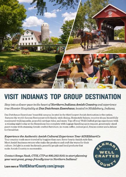
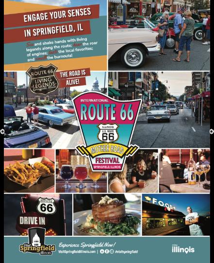
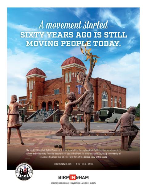
540-233-1121 Advertising Editor&Publisher StephenM.Kirchner bywaysmagazine.com stephen.kirchner@gmail.com BywaysonFacebook BywaysonTwitter BirminghamTourism,Alabama.....................................................................................................8 ColoradoSpringsSponsoredContent,Colorado.......................................................................13 DirectTVStream..............................................................................................................................37 DutchessTourism,NewYork.........................................................................................................9 DutchessTourismSponsoredContent,NewYork.......................................................................10 ElkhartCountyTourism,Indiana..................................................................................................5 GeneracHomeStandbyGenerator...............................................................................................43 SpringfieldTourism,Illinois...........................................................................................................6 WheelingTourism,WestVirginia...................................................................................................2